List of listed buildings in Caerlaverock, Dumfries and Galloway
This is a list of listed buildings in the parish of Caerlaverock in Dumfries and Galloway, Scotland.
List[]
| Name | Location | Date Listed | Grid Ref. [note 1] | Geo-coordinates | Notes | LB Number [note 2] | Image |
|---|---|---|---|---|---|---|---|
| Bankend Bridge (B725 Over Lochar Water) | 55°00′07″N 3°31′12″W / 55.001965°N 3.51987°W | Category B | 3798 | 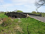
| |||
| Conheath House | 55°00′43″N 3°34′10″W / 55.011816°N 3.569332°W | Category B | 3803 | 
| |||
| Glencaple Quay | 55°00′10″N 3°34′27″W / 55.002668°N 3.574166°W | Category C(S) | 3807 |
| |||
| Kirkconnel Lea Garden Steps To South Of House | 54°59′12″N 3°33′37″W / 54.986733°N 3.56021°W | Category C(S) | 3811 |
| |||
| Caerlaverock House (Former Manse) | 55°00′30″N 3°31′40″W / 55.008301°N 3.527818°W | Category B | 3800 | 
| |||
| Conheath North Lodge and Gatepiers | 55°00′58″N 3°34′32″W / 55.015987°N 3.575548°W | Category B | 3805 |
| |||
| Caerlaverock Castle and arched Gateway to North East | 54°58′33″N 3°31′27″W / 54.975787°N 3.524068°W | Category A | 3799 | 
| |||
| Conheath Farm House | 55°00′50″N 3°34′18″W / 55.013995°N 3.571795°W | Category B | 3802 |
| |||
| Kirkconnel Lea Garden Shed To North Of House | 54°59′14″N 3°33′39″W / 54.98731°N 3.560764°W | Category C(S) | 3810 |
| |||
| Conheath Farm Steading Former Dovecot And Blocks Flanking Eastern Courtyard Entrance | 55°00′47″N 3°34′17″W / 55.013174°N 3.57134°W | Category B | 3814 |
| |||
| Conheath Private Chapel | 55°00′32″N 3°34′17″W / 55.008957°N 3.571488°W | Category B | 3804 |
| |||
| Kirkconnel Lea Sundial | 54°59′12″N 3°33′40″W / 54.986658°N 3.561177°W | Category C(S) | 3812 |
| |||
| Caerlaverock Parish Church and Churchyard | 55°00′28″N 3°31′33″W / 55.007696°N 3.525825°W | Category B | 3801 | 
| |||
| Kirkconnel Lea House and Gatepiers | 54°59′13″N 3°33′37″W / 54.986902°N 3.560342°W | Category B | 3808 |
| |||
| Kirkconnel Lea Double Well | 54°59′10″N 3°33′35″W / 54.986002°N 3.559729°W | Category C(S) | 3813 |
| |||
| Kirkconnel Lea Castellated Folly | 54°59′12″N 3°33′40″W / 54.986658°N 3.561177°W | Category B | 3809 |
| |||
| Conheath Walled Garden, Garden House And Summer House | 55°00′44″N 3°34′21″W / 55.012224°N 3.572585°W | Category B | 3806 |
| |||
| Isle Tower | 55°00′20″N 3°31′17″W / 55.005688°N 3.521313°W | Category B | 10236 | 
|
Key[]
The scheme for classifying buildings in Scotland is:
- Category A: "buildings of national or international importance, either architectural or historic; or fine, little-altered examples of some particular period, style or building type."[1]
- Category B: "buildings of regional or more than local importance; or major examples of some particular period, style or building type, which may have been altered."[1]
- Category C: "buildings of local importance; lesser examples of any period, style, or building type, as originally constructed or moderately altered; and simple traditional buildings which group well with other listed buildings."[1]
In March 2016 there were 47,288 listed buildings in Scotland. Of these, 8% were Category A, and 50% were Category B, with the remaining 42% being Category C.[2]
Notes[]
- ^ Sometimes known as OSGB36, the grid reference (where provided) is based on the British national grid reference system used by the Ordnance Survey.
• "Guide to National Grid". Ordnance Survey. Retrieved 2007-12-12.
• "Get-a-map". Ordnance Survey. Retrieved 2007-12-17. - ^ Historic Environment Scotland assign a unique alphanumeric identifier to each designated site in Scotland, for listed buildings this always begins with "LB", for example "LB12345".
References[]
- All entries, addresses and coordinates are based on data from Historic Scotland. This data falls under the Open Government Licence
- ^ a b c "What is Listing?". Historic Environment Scotland. Retrieved 29 May 2018.
- ^ Scotland's Historic Environment Audit 2016 (PDF). Historic Environment Scotland and the Built Environment Forum Scotland. pp. 15–16. Retrieved 29 May 2018.
Categories:
- Lists of listed buildings in Dumfries and Galloway