List of listed buildings in Glasserton, Dumfries and Galloway
This is a list of listed buildings in the parish of Glasserton in Dumfries and Galloway, Scotland.
List[]
| Name | Location | Date Listed | Grid Ref. [note 1] | Geo-coordinates | Notes | LB Number [note 2] | Image |
|---|---|---|---|---|---|---|---|
| Glasserton West Lodge Known As Butlers Lodge | 54°43′17″N 4°27′37″W / 54.721311°N 4.460404°W | Category B | 10139 | 
| |||
| Old Place Of Monreith, Or Dowies, With Carriage House And Boundary Walls | 54°45′22″N 4°31′01″W / 54.75608°N 4.516961°W | Category A | 10123 | 
| |||
| Physgill House | 54°42′01″N 4°26′27″W / 54.700377°N 4.440759°W | Category C(S) | 10127 |
| |||
| Ravenstone Castle | 54°46′02″N 4°28′27″W / 54.767279°N 4.474263°W | Category A | 10133 |
| |||
| Kirkmaiden Old Church And Burial Ground And Walled Churchyard | 54°43′41″N 4°32′23″W / 54.728054°N 4.539639°W | Category B | 10122 | 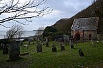
| |||
| Physgill House, Walled Garden And Stables | 54°42′01″N 4°26′15″W / 54.700406°N 4.437532°W | Category C(S) | 10128 |
| |||
| Glasserton Parish Church Church Of Scotland Session House Churchyard Mausolea And Monuments | 54°42′47″N 4°27′08″W / 54.712944°N 4.452305°W | Category A | 10137 | 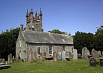
| |||
| Glasserton Mains Dovecot | 54°42′41″N 4°27′34″W / 54.71149°N 4.459312°W | Category B | 10143 |
| |||
| Glasserton The Posting House | 54°43′08″N 4°27′11″W / 54.718997°N 4.453043°W | Category C(S) | 10138 |
| |||
| Glasserton Home Farm Steading | 54°42′40″N 4°27′28″W / 54.711248°N 4.457916°W | Category C(S) | 10140 |
| |||
| Ravenstone Kennels | 54°45′53″N 4°28′26″W / 54.764776°N 4.473986°W | Category C(S) | 10134 |
| |||
| Stellock Farmhouse And Steadings | 54°44′23″N 4°32′06″W / 54.739648°N 4.53502°W | Category B | 10136 |
| |||
| Ravenstone School | 54°45′09″N 4°29′39″W / 54.752593°N 4.494302°W | Category C(S) | 10135 |
| |||
| Glasserton Kettle Cottage With Lamp Standard | 54°43′09″N 4°27′12″W / 54.719136°N 4.4533°W | Category C(S) | 10141 |
| |||
| Glasserton Ninian House | 54°43′08″N 4°27′13″W / 54.718823°N 4.453638°W | Category C(S) | 10142 |
| |||
| Glasserton Old Manse | 54°42′45″N 4°26′29″W / 54.71259°N 4.441353°W | Category C(S) | 10144 |
|

Key[]
The scheme for classifying buildings in Scotland is:
- Category A: "buildings of national or international importance, either architectural or historic; or fine, little-altered examples of some particular period, style or building type."[1]
- Category B: "buildings of regional or more than local importance; or major examples of some particular period, style or building type, which may have been altered."[1]
- Category C: "buildings of local importance; lesser examples of any period, style, or building type, as originally constructed or moderately altered; and simple traditional buildings which group well with other listed buildings."[1]
In March 2016 there were 47,288 listed buildings in Scotland. Of these, 8% were Category A, and 50% were Category B, with the remaining 42% being Category C.[2]
See also[]
| Wikimedia Commons has media related to Glasserton. |
Notes[]
- ^ Sometimes known as OSGB36, the grid reference (where provided) is based on the British national grid reference system used by the Ordnance Survey.
• "Guide to National Grid". Ordnance Survey. Retrieved 2007-12-12.
• "Get-a-map". Ordnance Survey. Retrieved 2007-12-17. - ^ Historic Environment Scotland assign a unique alphanumeric identifier to each designated site in Scotland, for listed buildings this always begins with "LB", for example "LB12345".
References[]
- All entries, addresses and coordinates are based on data from Historic Scotland. This data falls under the Open Government Licence
- ^ a b c "What is Listing?". Historic Environment Scotland. Retrieved 29 May 2018.
- ^ Scotland's Historic Environment Audit 2016 (PDF). Historic Environment Scotland and the Built Environment Forum Scotland. pp. 15–16. Retrieved 29 May 2018.
Categories:
- Lists of listed buildings in Dumfries and Galloway