List of listed buildings in Kirkliston, West Lothian

Kirkliston parish shown within West Lothian
This is a list of listed buildings in the parish of Kirkliston in West Lothian, Scotland.
List[]
| Name | Location | Date Listed | Grid Ref. [note 1] | Geo-coordinates | Notes | LB Number [note 2] | Image |
|---|---|---|---|---|---|---|---|
| Union Canal Bridge 31, Near Bell's Mill | 55°57′19″N 3°27′41″W / 55.955169°N 3.461362°W | Category C(S) | 7423 | 
| |||
| Union Canal Bridge 20, Near Muirend | 55°55′25″N 3°26′43″W / 55.923747°N 3.445232°W | Category C(S) | 7432 | 
| |||
| Union Canal Bridge 19, Near Lin's Mill | 55°55′23″N 3°26′23″W / 55.92304°N 3.439668°W | Category C(S) | 7431 | 
| |||
| Union Canal Bridge 21, Near Lookaboutye | 55°55′27″N 3°27′14″W / 55.924112°N 3.453935°W | Category C(S) | 7433 |
| |||
| Kilpunt Doocot | 55°55′52″N 3°26′42″W / 55.931011°N 3.444974°W | Category C(S) | 7435 |
| |||
| Illieston House (Elliston) | 55°54′52″N 3°26′24″W / 55.914489°N 3.440087°W | Category B | 7436 | 
| |||
| Union Canal Bridge 32, Main Road At Winchburgh | 55°57′36″N 3°27′51″W / 55.95988°N 3.464231°W | Category C(S) | 7424 | 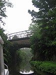
| |||
| Railway Viaduct, River Avon, Near Birds Mill | 55°55′35″N 3°25′44″W / 55.9265°N 3.428833°W | Category B | 7429 |
| |||
| Winchburgh, Main Street, Former Winchburgh Primary Schools Including Boundary Walls And Outbuildings | 55°57′35″N 3°27′21″W / 55.959817°N 3.455867°W | Category C(S) | 49194 |
| |||
| Old Auldcathie Kirk | 55°58′06″N 3°28′40″W / 55.968381°N 3.47769°W | Category C(S) | 13649 |
| |||
| Railway Viaduct, Almond Valley | 55°56′04″N 3°25′21″W / 55.934482°N 3.422403°W | Category A | 7428 |
| |||
| Union Canal Bridge 33, Near Myre | 55°57′53″N 3°27′52″W / 55.964801°N 3.464481°W | Category C(S) | 7425 |
| |||
| Union Canal Bridge 34, Near Auldcathie Kirk | 55°58′09″N 3°28′27″W / 55.969287°N 3.47412°W | Category C(S) | 7426 | 
| |||
| Railway Viaduct, Broxburn-Newbridge Road | 55°56′15″N 3°25′59″W / 55.937431°N 3.433062°W | Category A | 7427 |
| |||
| Union Canal, Almond Aqueduct, River Avon Near Linn's Mill | 55°55′13″N 3°26′02″W / 55.92032°N 3.433982°W | Category A | 7430 | 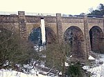
| |||
| Union Canal Bridge 30, Near Broomhouse | 55°57′05″N 3°27′10″W / 55.951462°N 3.452702°W | Category C(S) | 7438 | 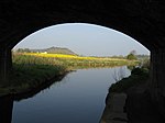
| |||
| Union Canal Bridge 22, At Learielaw | 55°55′31″N 3°27′35″W / 55.925329°N 3.459694°W | Category C(S) | 7434 |
| |||
| Niddry Castle | 55°57′14″N 3°27′02″W / 55.953842°N 3.450533°W | Category A | 7437 |
|

Key[]
The scheme for classifying buildings in Scotland is:
- Category A: "buildings of national or international importance, either architectural or historic; or fine, little-altered examples of some particular period, style or building type."[1]
- Category B: "buildings of regional or more than local importance; or major examples of some particular period, style or building type, which may have been altered."[1]
- Category C: "buildings of local importance; lesser examples of any period, style, or building type, as originally constructed or moderately altered; and simple traditional buildings which group well with other listed buildings."[1]
In March 2016 there were 47,288 listed buildings in Scotland. Of these, 8% were Category A, and 50% were Category B, with the remaining 42% being Category C.[2]
Notes[]
- ^ Sometimes known as OSGB36, the grid reference (where provided) is based on the British national grid reference system used by the Ordnance Survey.
• "Guide to National Grid". Ordnance Survey. Retrieved 2007-12-12.
• "Get-a-map". Ordnance Survey. Retrieved 2007-12-17. - ^ Historic Environment Scotland assign a unique alphanumeric identifier to each designated site in Scotland, for listed buildings this always begins with "LB", for example "LB12345".
References[]
- All entries, addresses and coordinates are based on data from Historic Scotland. This data falls under the Open Government Licence
- ^ a b c "What is Listing?". Historic Environment Scotland. Retrieved 29 May 2018.
- ^ Scotland's Historic Environment Audit 2016 (PDF). Historic Environment Scotland and the Built Environment Forum Scotland. pp. 15–16. Retrieved 29 May 2018.
Categories:
- Lists of listed buildings in West Lothian