List of listed buildings in Newtyle, Angus
This is a list of listed buildings in the parish of in Angus, Scotland.
List[]
| Name | Location | Date Listed | Grid Ref. [note 1] | Geo-coordinates | Notes | LB Number [note 2] | Image |
|---|---|---|---|---|---|---|---|
| Newtyle Parish Kirk | 56°33′28″N 3°08′49″W / 56.557716°N 3.146889°W | Category B | 17996 | 
| |||
| Hatton Castle | 56°33′23″N 3°08′15″W / 56.556445°N 3.137512°W | Category B | 17999 | 
| |||
| 35, 37, 39 Belmont Street Newtyle | 56°33′31″N 3°08′33″W / 56.55859°N 3.142636°W | Category C(S) | 18002 |
| |||
| Parish Kirk Manse | 56°33′24″N 3°08′44″W / 56.556784°N 3.145641°W | Category C(S) | 19848 | 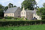
| |||
| 33 Church Street Newtyle | 56°33′31″N 3°08′40″W / 56.558691°N 3.144348°W | Category C(S) | 19849 |
| |||
| Old Observatory, Kinpurney Hill | 56°33′46″N 3°06′14″W / 56.562687°N 3.103854°W | Category B | 18005 |
| |||
| Millhole, Road Bridge Over Former Dundee And Newtyle Railway | 56°32′46″N 3°07′18″W / 56.546132°N 3.121621°W | Category C(S) | 49914 |
| |||
| Bannatyne House | 56°33′20″N 3°09′02″W / 56.555661°N 3.150471°W | Category B | 17998 |
| |||
| A P Morris Church Street Newtyle | 56°33′31″N 3°08′39″W / 56.558657°N 3.144184°W | Category C(S) | 18001 |
| |||
| Kinpurnie Castle | 56°33′05″N 3°09′55″W / 56.551391°N 3.165161°W | Category B | 18006 |
| |||
| Davidston, Road Bridge Over Former Dundee And Newtyle Railway | 56°32′35″N 3°06′59″W / 56.542979°N 3.116502°W | Category C(S) | 49913 |
| |||
| Kinpurnie Castle - Lodge Gates | 56°33′09″N 3°09′53″W / 56.552537°N 3.164708°W | Category B | 18008 |
| |||
| 44 Belmont Street Newtyle | 56°33′30″N 3°08′38″W / 56.558292°N 3.143799°W | Category C(S) | 18003 |
| |||
| Kinpurnie Castle - Lodge | 56°33′09″N 3°09′52″W / 56.552467°N 3.164413°W | Category B | 18007 |
| |||
| Former Railway Goods Station, Commercial Street Newtyle, Including Stepped Plinth Of Former Crane | 56°33′32″N 3°08′28″W / 56.558972°N 3.141151°W | Category B | 18009 | 
| |||
| Newtyle Parish Kirkyard | 56°33′27″N 3°08′49″W / 56.557527°N 3.146883°W | Category B | 17997 |
| |||
| 1, 3 Castle Street Newtyle | 56°33′30″N 3°08′36″W / 56.558234°N 3.143244°W | Category C(S) | 18000 |
| |||
| Nethermill | 56°34′26″N 3°09′00″W / 56.573841°N 3.15003°W | Category B | 18004 |
| |||
| Near East Kinpurnie, Rail Bridge Over Former Dundee And Newtyle Railway | 56°33′31″N 3°09′15″W / 56.558573°N 3.15422°W | Category C(S) | 49912 |
| |||
| East Kinpurnie, Rail Bridge Over Former Dundee And Newtyle Railway | 56°33′24″N 3°09′33″W / 56.556551°N 3.159137°W | Category C(S) | 49892 |
|
Key[]
The scheme for classifying buildings in Scotland is:
- Category A: "buildings of national or international importance, either architectural or historic; or fine, little-altered examples of some particular period, style or building type."[1]
- Category B: "buildings of regional or more than local importance; or major examples of some particular period, style or building type, which may have been altered."[1]
- Category C: "buildings of local importance; lesser examples of any period, style, or building type, as originally constructed or moderately altered; and simple traditional buildings which group well with other listed buildings."[1]
In March 2016 there were 47,288 listed buildings in Scotland. Of these, 8% were Category A, and 50% were Category B, with the remaining 42% being Category C.[2]
See also[]
Notes[]
- ^ Sometimes known as OSGB36, the grid reference (where provided) is based on the British national grid reference system used by the Ordnance Survey.
• "Guide to National Grid". Ordnance Survey. Retrieved 2007-12-12.
• "Get-a-map". Ordnance Survey. Retrieved 2007-12-17. - ^ Historic Environment Scotland assign a unique alphanumeric identifier to each designated site in Scotland, for listed buildings this always begins with "LB", for example "LB12345".
References[]
- All entries, addresses and coordinates are based on data from Historic Scotland. This data falls under the Open Government Licence
- ^ a b c "What is Listing?". Historic Environment Scotland. Retrieved 29 May 2018.
- ^ Scotland's Historic Environment Audit 2016 (PDF). Historic Environment Scotland and the Built Environment Forum Scotland. pp. 15–16. Retrieved 29 May 2018.
Categories:
- Lists of listed buildings in Angus