List of listed buildings in Ruthven, Angus
This is a list of listed buildings in the parish of Ruthven in Angus, Scotland.
List[]
| Name | Location | Date Listed | Grid Ref. [note 1] | Geo-coordinates | Notes | LB Number [note 2] | Image |
|---|---|---|---|---|---|---|---|
| Ruthven Parish Kirk | 56°37′34″N 3°09′58″W / 56.626223°N 3.166211°W | Category C(S) | 17599 | 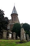
| |||
| Old Post Office Ruthven | 56°37′31″N 3°09′48″W / 56.625161°N 3.163456°W | Category C(S) | 17602 | 
| |||
| Ruthven House - Ice House | 56°37′05″N 3°08′20″W / 56.61803°N 3.138907°W | Category C(S) | 19806 |
| |||
| Ruthven Castle | 56°37′04″N 3°08′20″W / 56.61786°N 3.13887°W | Category B | 17598 |
| |||
| Ruthven Bridge Over River Isla | 56°37′35″N 3°09′35″W / 56.626401°N 3.159664°W | Category B | 17600 | 
| |||
| Bridgend Cottage Ruthven | 56°37′35″N 3°09′33″W / 56.626325°N 3.159075°W | Category C(S) | 17601 |
| |||
| Milton Of Ruthven Farmhouse | 56°37′30″N 3°09′15″W / 56.624907°N 3.154126°W | Category C(S) | 17596 |
| |||
| Kirk House Barn | 56°37′33″N 3°10′03″W / 56.625959°N 3.167491°W | Category C(S) | 17603 |
| |||
| Ruthven Old Bridge Over River Isla | 56°37′35″N 3°09′35″W / 56.626481°N 3.159699°W | Category B | 19807 |
|

Key[]
The scheme for classifying buildings in Scotland is:
- Category A: "buildings of national or international importance, either architectural or historic; or fine, little-altered examples of some particular period, style or building type."[1]
- Category B: "buildings of regional or more than local importance; or major examples of some particular period, style or building type, which may have been altered."[1]
- Category C: "buildings of local importance; lesser examples of any period, style, or building type, as originally constructed or moderately altered; and simple traditional buildings which group well with other listed buildings."[1]
In March 2016 there were 47,288 listed buildings in Scotland. Of these, 8% were Category A, and 50% were Category B, with the remaining 42% being Category C.[2]
See also[]
Notes[]
- ^ Sometimes known as OSGB36, the grid reference (where provided) is based on the British national grid reference system used by the Ordnance Survey.
• "Guide to National Grid". Ordnance Survey. Retrieved 2007-12-12.
• "Get-a-map". Ordnance Survey. Retrieved 2007-12-17. - ^ Historic Environment Scotland assign a unique alphanumeric identifier to each designated site in Scotland, for listed buildings this always begins with "LB", for example "LB12345".
References[]
- All entries, addresses and coordinates are based on data from Historic Scotland. This data falls under the Open Government Licence
- ^ a b c "What is Listing?". Historic Environment Scotland. Retrieved 29 May 2018.
- ^ Scotland's Historic Environment Audit 2016 (PDF). Historic Environment Scotland and the Built Environment Forum Scotland. pp. 15–16. Retrieved 29 May 2018.
Categories:
- Lists of listed buildings in Angus