List of mills in Lancashire

This is an incomplete list of the cotton and other textile mills that were located within the modern-day boundaries of the ceremonial county of Lancashire, England. The first mills were built in the 1760s, in Derbyshire using the Arkwright system and were powered by the water. When stationary steam engines were introduced they still needed water, so the mills were built along rivers and canals. As a broad rule of thumb, spinning mills were built in the south-east of the county, and weaving sheds to the north and west. Parts of Lancashire have been subsumed into Greater Manchester and Merseyside, and are not included in this list. Parts of Yorkshire are now included in this county.
Accrington[]
'Home of Howard & Bullough'
| Name | Architect | Location | Built | Demolished | Served (Years) |
|---|---|---|---|---|---|
| Broad Oak Mill | SD759283 53°45′04″N 2°22′01″W / 53.751°N 2.367°W | ||||
| Notes: A combined mill- 38,200 spindles, 301/501 weft; 778 looms for John Hargraves and Co. Also room and power 576 looms for Broad Oak Manufacturing Co, Limited. [1] | |||||
| Spring Hill Mill | SD746279 53°44′49″N 2°23′13″W / 53.747°N 2.387°W | ||||
| Union Mill | SD746281 53°44′56″N 2°23′13″W / 53.749°N 2.387°W | ||||
| Woodnook Mill | SD759277 53°44′42″N 2°22′01″W / 53.745°N 2.367°W | 2009 | |||
 |
Notes: 100,312 spindles for Accrington Cotton Spinning and Manufacturing Co. Limited.[1] | ||||
| Victoria Mill, Wood Nook | |||||
| Notes: 19,712 spindles for Holt and Co. [1] | |||||
| Ellesmere Mill, Victoria street | |||||
| Notes: 582 looms for T. A. Griffiths [1] | |||||
| Lodge Mill | |||||
| Broad Oak Printworks | SD767279 53°44′49″N 2°21′18″W / 53.747°N 2.355°W | ||||
| Baxenden Printworks | SD776259 53°43′44″N 2°20′28″W / 53.729°N 2.341°W | ||||
| Alliance Mill | |||||
| Broomfield Mill | |||||
| Notes: Accrington Cotton Spinning and Manufacturing Co. Limited [1] | |||||
| Grimshaw Street Mill | |||||
| Notes: Accrington Cotton Spinning and Manufacturing Co. Limited [1] | |||||
| Perseverance Mill | |||||
| Notes: 618 looms for Accrington Cotton Spinning and Manufacturing Co. Limited [1] | |||||
| Victoria Mill | |||||
 |
Notes: 1829 looms for William Smith and Co [1] | ||||
| Queen Mill | SD764293 53°45′36″N 2°21′32″W / 53.760°N 2.359°W | ||||
 |
Notes: | ||||
| Hambledon Mill | SD761296 53°45′43″N 2°21′50″W / 53.762°N 2.364°W | ||||
| Fountain Mill | SD756289 53°45′22″N 2°22′19″W / 53.756°N 2.372°W | ||||
| [1][2] | |||||

Bacup[]
Rossendale| Name | Architect | Location | Built | Demolished | Served (Years) |
|---|---|---|---|---|---|
| Acre Mill | Stacksteads 53°41′28″N 2°13′12″W / 53.691°N 2.220°W | ||||
 |
Notes: | ||||
| Britannia Mills | SD880215 53°41′24″N 2°10′59″W / 53.690°N 2.183°W | ||||
 |
Notes: Sutcliffe and Smith, 12,000 spindles, 121/301; 400 looms | ||||
| Broadclough Mill | SD868242 53°42′50″N 2°12′04″W / 53.714°N 2.201°W | Early 19th century | |||
 |
Notes: Grade II listed building[3] 1891: Harry Whitehead and Co,17,000 spindles, 400 looms |
||||
| Farholme Mill | 53°41′31″N 2°13′01″W / 53.692°N 2.217°W | 1853 | 168 | ||
 |
Notes: 1891: (together with Kilnholme Mill) New Bacup and Wardle Commercial Co, Limited, 60,292 spindles, 261/301 twist, 281/401 weft; 1,320 looms | ||||
| Forest Mill | Market Street 53°42′00″N 2°12′00″W / 53.700°N 2.200°W | ||||
 |
Notes: To be demolished | ||||
| Irwell Mills | |||||
| Notes: 1891: (together with Weir Mill) Rossendale Industrial Co, Limited, 40,000 spindles, 201/248; 1,000 looms | |||||
| Irwell Springs Printworks | SD874257 | ||||
| Kilnholme Mill | |||||
| Notes: 1891: (together with Farholme Mill) New Bacup and Wardle Commercial Co, Limited, 60,292 spindles, 261/301 twist, 281/401 weft; 1,320 looms | |||||
| Meadows Mill | 53°42′36″N 2°12′11″W / 53.710°N 2.203°W | ||||
 |
Notes: 1891: (together with Olive Mills) J. J. Hoyle Brothers, 32,000 spindles; 766 looms | ||||
| New Hey Mill | Newchurch Road 53°41′45″N 2°12′12″W / 53.695799°N 2.203208°W | ||||
 |
Notes: | ||||
| Olive Mill | SD862217 53°41′31″N 2°12′36″W / 53.692°N 2.210°W | ||||
 |
Notes: 1891: (together with Meadows Mills) J. J. Hoyle Brothers, 32,000 spindles; 766 looms | ||||
| Ross Mills | SD870220 53°41′38″N 2°11′53″W / 53.694°N 2.198°W | ||||
| Rossendale Mill | SD849216 53°41′28″N 2°13′48″W / 53.691°N 2.230°W | 1860 | 161 | ||
| Notes: aka Atherton Holme Mill Spencer Brothers |
|||||
| Stacksteads Mill | SD855218 53°41′31″N 2°13′16″W / 53.692°N 2.221°W | 1833 | 188 | ||
| Notes: Grade II listed building[4] 1891: George Ormerod, 320 looms Now the Toll Bar Business Park |
|||||
| Victoria Mill | |||||
| Notes: 1891: William Hall, 5,000 spindles, 241/2611 twist, 181/361 weft; 130 looms | |||||
| Waterside Mills | SD867234 53°42′25″N 2°12′11″W / 53.707°N 2.203°W | 1839 | 182 | ||
 |
Notes: Grade II listed building[5] | ||||
| [6] | |||||
Source 1891 data: Grace's Guide
Barnacre[]
| Name | Architect | Location | Built | Demolished | Served (Years) |
|---|---|---|---|---|---|
| Calder Vale Mill | SD533458 53°54′22″N 2°42′43″W / 53.906°N 2.712°W | ||||
| Barnacre Weaving Co. | SD531452 53°54′04″N 2°42′54″W / 53.901°N 2.715°W | ||||
| [7] | |||||
Barnoldswick[]
| Name | Owner | Location | Built | Demolished | Served (Years) |
|---|---|---|---|---|---|
| Bancroft Mill | SD874461 53°54′40″N 2°11′35″W / 53.911°N 2.193°W | ||||
 |
Notes: Started in 1914 and commissioned in 1920 for James Nutter & Sons Limited. It closed in 1979 and was demolished. The boilers, engine house and chimneys were preserved and subsequently maintained as a working steam museum. It was the last steam driven weaving shed to be constructed and the last to close, and is well documented. The engine house is open to visitors and the William Roberts & Co of Nelson cross compound 600hp engine regularly runs from steam generated from donated scrap wood | ||||
| Bankfield Shed | Bradley Brothers | SD882475 53°55′23″N 2°10′52″W / 53.923°N 2.181°W | standing | ||
| Notes: When it opened in 1905 Bankfield was reputed to be the world's largest weaving shed. James Nutter was the first tenant and was responsible for 900 looms, but shared the shed with the Bradley Brothers who had another 900 looms. James Nutter and Son continued weaving at Bankfield even after they had completed Bancroft Shed, although James Nutter himself had died in 1914. Weaving stopped in 1920. It 1939 it became a shadow factory for Rover, and then taken over by Rolls Royce for aero-engine production. The 'B' in a Rolls Royce engine name (e.g. a RB211) designates it was designed in Barnoldswick.[8] | |||||
| Butts Mill | |||||
| Calf Hall Shed | |||||
| Notes: The room and power mill where James Nutter had 414 looms in 1900.[9] | |||||
| Clough Mills | Slater Brothers | ||||
| Notes: The room and power mill where James Nutter and Slater Edmondson were in partnership in the early 1880s.[9] | |||||
| Crow Nest Mill | 53°55′20″N 2°11′05″W / 53.9223°N 2.1848°W | ||||
 |
Notes: | ||||
| Fernbank Mill | |||||
| Hope Mill | |||||
 |
Notes: | ||||
| Long Ings | SD88446953°55′05″N 2°10′41″W / 53.918°N 2.178°W | ||||
| Notes: The room and power mill where James Nutter and Slater Edmondson were in partnership in 1888 having 400 looms.[9] | |||||
| Lower Barnsay | |||||
| Old Coates Mill | |||||
| Notes: The engine was bought by Wilson Wood Colliery, in Ingleton[10] | |||||
| New Coates Mill | |||||
| Notes: The room and power mill where James Nutter had 56 looms in 1880.[9] | |||||
| Wellhouse Mills | |||||
| Westfield Mill | |||||
| [11] | |||||
Blackburn[]
'Home of Northrop Loom Works' and


Brierfield[]
| Name | Architect | Location | Built | Demolished | Served (Years) |
|---|---|---|---|---|---|
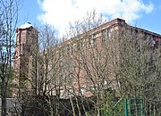
| Brierfield Mills | SD844365 53°49′30″N 2°14′17″W / 53.825°N 2.238°W | 1868 | 153 | ||
 |
Notes: Grade II listed building[13] | ||||
Burnley[]
The home of Butterworth & Dickinson and Queen Street Mill Textile Museum
| Name | Architect | Location | Built | Demolished | Served (Years) |
|---|---|---|---|---|---|
| Ashfield Shed | SD837328 53°47′28″N 2°14′56″W / 53.791°N 2.249°W | ||||
 |
Notes: 1891 - J H Whittaker | ||||
| Calder Vale Shed | |||||
 |
Notes: 1891-Waring and Phillips (517 looms), William Brierley (488 looms) and Thomas Burrows (289 looms) | ||||
| Elm Street Mill | SD841337 53°47′59″N 2°14′32″W / 53.799718°N 2.242123°W | ||||
 |
Notes: The 600hp Galloway mill engine is now on display at Museum of Science and Industry, Manchester | ||||
| Pentridge Mill | 53°47′13″N 2°14′20″W / 53.787°N 2.239°W | ||||
 |
Notes: 1891-E. F. Bleakley and Brother, 33,260 spindles | ||||
| Stanley Mill | 53°48′04″N 2°13′59″W / 53.801°N 2.233°W | ||||
 |
Notes: | ||||
| Waterloo Shed | SD836324 53°47′17″N 2°15′00″W / 53.788°N 2.250°W | ||||
| Notes: 1891-William Sutcliffe, 444 looms | |||||
| Trafalgar Mill | Trafalgar Street | 1846 | 175 | ||
 |
Notes: 1846-W H Halstead 1891-William Thompson and Sons, together with Hope Shed, 26,063 spindles and 625 looms |
||||
| Clock Tower Mill (Sandygate Mill) | SD836325 53°47′20″N 2°15′00″W / 53.789°N 2.250°W | ||||
 |
Notes: 1891-Sandy Gate Mill Co, Limited, 20,000 spindles and 419 looms | ||||
| Sandygate Shed | Wiseman Street | ||||
| Notes: Turner Oates, 24 looms | |||||
| Wiseman Street Mill | SD835326 53°47′20″N 2°15′07″W / 53.789°N 2.252°W | ||||
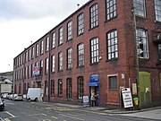
| Victoria Mill | Trafalgar Street SD833326 53°47′20″N 2°15′18″W / 53.789°N 2.255°W | 1855 | 166 | ||
 |
Notes: Grade II listed building[14] 1855-Massey family 1891-Victoria Mill Co Ltd, 19,000 spindles |
||||
| Woodfield Mill | |||||
 |
Notes: 1891-Thomas Cowpe and Sons, 1,317 looms | ||||
| Proctor's Mill foundry | Cow Lane 53°47′17″N 2°14′46″W / 53.788°N 2.246°W | ||||
 |
Notes: 2001: Lava and Ignite night club. 2017: Luxury apartments planned |
||||
| Bellevue Mill | Westgate SD 833326 53°47′24″N 2°15′18″W / 53.790°N 2.255°W | 1863 | 158 | ||
 |
Notes: Grade II listed building[15] 1891-Simpson and West, together with Harle Syke Shed, Briercliffe, 900 looms |
||||
| Finsley Mill | SD842321 53°47′06″N 2°14′28″W / 53.785°N 2.241°W | ||||
 |
Notes: 1891-Witham Brothers, together with Plumbe Street Shed, 48,504 spindles and 1,506 looms | ||||
| Plumbe Street Shed | |||||
| Notes: 1891-Witham Brothers, together with Finsley Mill, 48,504 spindles and 1,506 looms | |||||
| Dean Mills | |||||
| Central Mill | |||||
| Notes: 1891-Edward Houlding, 665 looms | |||||
| Park Mill | |||||
| Old Mill | SD847322 53°47′10″N 2°14′02″W / 53.786°N 2.234°W | ||||
 |
Notes: | ||||
| Daneshouse Mill | SD841337 53°47′56″N 2°14′35″W / 53.799°N 2.243°W | ||||
| Notes: 1891-Benjamin Thornber and Sons, together with Throstle Mills and Old Hall Shed, 43,000 spindles and 2,028 looms | |||||
| Old Hall Mill | |||||
 |
Notes: 1891-Benjamin Thornber and Sons, together with Danes House and Throstle Mills, 43,000 spindles and 2,028 looms | ||||
| Newtown Mill | |||||
 |
Notes: 1891-Tunstill Brothers, together with Brierfield Mills, Brierfield and Throstle Nest Mill, Nelson, 117,000 spindles and 2,800 looms | ||||
| Westgate Mill | Sandygate | ||||
 |
Notes: 1891-Butterworth and Dickinson, 400 looms | ||||
| Queen Street Mill | |||||
| Notes: 1891-Whitehead and Altham, 385 looms | |||||
| Throstle Mill | |||||
| Notes: 1891-Benjamin Thornber and Sons, together with Danes House Mills and Old Hall Shed, 43,000 spindles and 2,028 looms | |||||
| Livingstone Mill | SD840342 53°48′14″N 2°14′38″W / 53.804°N 2.244°W | ||||
 |
Notes: | ||||
| Cameron Mill | SD841342 53°48′14″N 2°14′35″W / 53.804°N 2.243°W | ||||
 |
Notes: | ||||
| Woodbine Mill | SD821327 53°47′24″N 2°16′23″W / 53.790°N 2.273°W | ||||
| Peel Mill | |||||
| Lowerhouse Mill and Printworks | SD804329 53°47′31″N 2°17′56″W / 53.792°N 2.299°W | ||||
| Notes: 1891-Alexander Drew and Sons | |||||
| Wood Top Mill | |||||
 |
Notes: 1891-Robert Crabtree and Co, 1000 looms | ||||
| [16][17] | |||||
Cheesden Valley[]
| Name | Architect | Location | Built | Demolished | Served (Years) |
|---|---|---|---|---|---|
| SD824161 53°38′29″N 2°16′02″W / 53.6413°N 2.2673°W | 1810 | ||||
| Notes: Cotton Mill | |||||
| SD824161 53°38′29″N 2°16′02″W / 53.6413°N 2.2673°W | 1810 | demised | |||
| Notes: Initially spun and carded wool for domestic outworkers, but was spinning cotton by 1838 | |||||
| SD824161 53°38′29″N 2°16′02″W / 53.6413°N 2.2673°W | 1830s | demised | |||
| (Bridge Mill) | SD824161 53°38′29″N 2°16′02″W / 53.6413°N 2.2673°W | 1840 | 1898 | 58 | |
| Notes: This was a two-storey mill, at one point being used for woollen manufacture upstairs and cotton spinning downstairs. It was later used for waste twills and calicos | |||||
| SD824161 53°38′29″N 2°16′02″W / 53.6413°N 2.2673°W | 1845 | demised | |||
| Notes: Cotton | |||||
| SD824161 53°38′29″N 2°16′02″W / 53.6413°N 2.2673°W | 1786 | demised | |||
 |
Notes: Woollen | ||||
| SD824161 53°38′29″N 2°16′02″W / 53.6413°N 2.2673°W | 1834 | demised | |||
| Notes: Printing Works | |||||
| SD824161 53°38′29″N 2°16′02″W / 53.641300°N 2.267300°W | 1801 | ruins found | |||
| Notes: Cotton finishing works | |||||
| SD824161 53°38′29″N 2°16′02″W / 53.6413°N 2.2673°W | pre-1880s | demised | |||
| Notes: Bleaching of cotton waste | |||||
| SD824161 53°38′29″N 2°16′02″W / 53.6413°N 2.2673°W | 1824 | ruins found | |||
 |
Notes: Bircle. This was a full-scale 4-storey cotton spinning mill and weaving shed, The mill produced its own gas and was powered by a large waterwheel and auxiliary engine. | ||||
| SD824161 53°38′29″N 2°16′02″W / 53.6413°N 2.2673°W | 1780 | demised | |||
| Notes: A fustian mill, producing thick, coarse cotton material. | |||||
Chipping[]
| Name | Architect | Location | Built | Demolished | Served (Years) |
|---|---|---|---|---|---|
| Kirk Mill | 1780 | Standing | 106 | ||
 |
Notes: Grade II listed building[18] An original built in the 1780s. The mill continued spinning cotton using water frames and then throstles until 1886, when it was sold and became HJ Berry's chairmaking factory. It was powered by a 32 ft waterwheel which continued in use, generating electricity until the 1940s.[19] |
||||
| Saunderrake Factory | SD614438 53°53′20″N 2°35′20″W / 53.889°N 2.589°W | ||||
| Wharf Mill | SD623433 53°53′06″N 2°34′30″W / 53.885°N 2.575°W | ||||
Chorley[]
| Name | Architect | Location | Built | Demolished | Served (Years) |
|---|---|---|---|---|---|
| Albert Mills | East Street 53°39′11.54″N 2°37′30.73″W / 53.6532056°N 2.6252028°W | ||||
| Notes: 1891-George Brown and Co, together with Primrose Bank Mill, 86,000 spindles and 992 looms | |||||
| Brunswick Mill | Standish Street 53°38′59.52″N 2°37′38.76″W / 53.6498667°N 2.6274333°W | ||||
| Notes: 1891-James Gillett, 418 looms | |||||
| Birkacre Mill | 1777 | 244 | |||
| Notes: Arkwright's Mill leased in 1777 for £180 per annum, fitted with water frames and burnt down in 1779. Over 2 days, 2000 'wild' people from Chorley burned down part of the mill. 1 person was drowned, 2 killed and 8 wounded.[20][21] | |||||
| Birkacre Printworks | SD571151 53°37′52″N 2°39′00″W / 53.631°N 2.650°W | ||||
| Canal Mill | 53°40′2.74″N 2°37′16.22″W / 53.6674278°N 2.6211722°W | 1855 | Standing | 166 | |
 |
Notes: Built in 1855 during the Crimean War. 1891-William and Charles Widdows, 46,360 spindles. Ceased to produce cotton in the late 1950s. Purchased by Gilbraiths Commercial, who serviced trucks, notably Leyland vehicles, in 1968, and eventually began to wind down operations in 1991 concurrent to the crash of Leyland DAF. The following year planning permission was given to turn the mill into a 'themed visitor attraction' and it has been Botany Bay Villages shopping centre since 1995.[22] | ||||
| Croft Mill | 53°38′55.54″N 2°37′56.33″W / 53.6487611°N 2.6323139°W | 1852 | 1982 | 130 | |
| Notes: 1891-Rice and Co, Limited, 560 looms | |||||
| Coronation Mill | 53°39′33.86″N 2°37′31.13″W / 53.6594056°N 2.6253139°W | ||||
| Cowling Bridge Mill | 53°38′45.50″N 2°36′40.48″W / 53.6459722°N 2.6112444°W | 1793 | 228 | ||
| Cowling Mill | 53°38′45″N 2°36′48.16″W / 53.64583°N 2.6133778°W | 1906 | Standing | 115 | |
 |
Notes: 1891-J H Gillett and Sons, 40,852 spindles | ||||
| Crosse Hall Mill | 53°38′55.05″N 2°36′45.29″W / 53.6486250°N 2.6125806°W | 1838 | Standing | 183 | |
 |
Notes: 1786 to 1793-James Duxbury, Rice and Evans. Business failed. 1793-Hall, Wilkinson and Gartside 1838-Richard Cobden and Bro. |
||||
| Diamond Mill | 53°39′11.25″N 2°38′40″W / 53.6531250°N 2.64444°W | 1998 | |||
| Notes: George Edge | |||||
| Euxton Mill | 53°39′26.73″N 2°41′4.45″W / 53.6574250°N 2.6845694°W | 2010 | |||
| Notes: 1891-Peter Priestley, 15,000 spindles | |||||
| Fosterfield Mill | 53°39′29.37″N 2°37′10.26″W / 53.6581583°N 2.6195167°W | 1905 | 1984 | 79 | |
| Notes: 1891-J. and T. Heyworth, 850 looms | |||||
| Grimeford Mill (Anderton) | 53°36′39.09″N 2°34′48.76″W / 53.6108583°N 2.5802111°W | 1899 | Standing | 122 | |
 |
Notes: c.1940- Adlington Manufacturing Co, 430 looms 2016- Internet retail sales and car body repair |
||||
| Grime Street Weaving Shed | 53°38′36″N 2°37′36.34″W / 53.64333°N 2.6267611°W | 1914 | 1981 | 67 | |
| Notes: Built as a weaving shed in 1914, sold to Leyland Motors on outbreak of war and never used for cotton. Redeveloped as modern Multipart plant in 1981. | |||||
| Greenfield Mill | Steely Lane 53°39′11.46″N 2°37′24.56″W / 53.6531833°N 2.6234889°W | 1861 | 160 | ||
| Notes: 1891-William Brindle and Co, 711 looms | |||||
| Grove Mill (Eccleston) | 53°38′29.34″N 2°43′15.33″W / 53.6414833°N 2.7209250°W | ||||
| Notes: 1891-Carrington, Woods and Co, 930 looms | |||||
| Heapey Works | 53°40′0.26″N 2°36′11.20″W / 53.6667389°N 2.6031111°W | 1872 | 1989 | 117 | |
| Notes: Generated its own electricity, had its own railway line, and included a paper mill and printing plant. | |||||
| Hope Mill | Botany 53°39′51.88″N 2°37′3.29″W / 53.6644111°N 2.6175806°W | 1903 | 118 | ||
| Notes: 1891-Thomas Howarth, together with Progress Mill, 435 looms | |||||
| Lawrences Mills | 53°39′0.49″N 2°37′25.06″W / 53.6501361°N 2.6236278°W | 1866 | 2010 | 144 | |
| Notes: William Lawrence. The last mill in Chorley producing cotton goods until its closure in 2010. | |||||
| Lower Healey Works | 53°39′23.67″N 2°36′34.24″W / 53.6565750°N 2.6095111°W | Standing | |||
| Notes: Former home to the last Thomas Witters factory in Chorley which produced carpets and closed in 2001.[23] Currently part of Lower Healer Business Park, an industrial estate situated at the foot of Healey Nab. | |||||
| Mayfield Mill | 53°39′25.38″N 2°37′33.83″W / 53.6570500°N 2.6260639°W | Standing | |||
| Moor Mill | 53°38′49″N 2°36′1.26″W / 53.64694°N 2.6003500°W | 1852 | Standing | 169 | |
| Notes: 1891-Nixon and Killick, 33,028 spindles and 538 looms | |||||
| North Street Mill | 53°39′42.89″N 2°37′45.30″W / 53.6619139°N 2.6292500°W | ||||
| Notes: 1891-Chorley Cotton Spinning and Manufacturing Co Ltd,115,000 spindles and 970 looms | |||||
| Park Mills | 53°38′46.27″N 2°38′24.74″W / 53.6461861°N 2.6402056°W | 1914 | 2011 | 97 | |
| Notes: Joseph Blackledge & Sons | |||||
| Primrose Mill | 53°39′17.04″N 2°37′32.41″W / 53.6547333°N 2.6256694°W | 1861 | Standing | 160 | |
 |
Notes: 1891-George Brown and Co,together with Albert Mills, 86,000 spindles and 992 looms | ||||
| Progress Mill | 53°39′9.81″N 2°37′17.23″W / 53.6527250°N 2.6214528°W | 1886 | Standing | 135 | |
 |
Notes: 1891-Thomas Howarth, together with Hope Mill, 435 looms. Still stands today as Droyt Soap Factory. | ||||
| Sherbourne Mill | 53°39′6.75″N 2°37′27.66″W / 53.6518750°N 2.6243500°W | 1840 | Standing | 181 | |
 |
Notes: Lawrence Anyon. . Formerly site of Courtella-owned W.G. Underhills which made fabrics until its closure in 1984. Now a timber and DIY shop. | ||||
| Talbot Mill | SD596182 53°39′32″N 2°36′47″W / 53.659°N 2.613°W | 1906 | 2002 | 96 | |
| Notes: Talbot Spinning & Weaving Co. Diversified into plastics production after the decline of the cotton industry in the post-war period. Spinning Division closed and demolished in 1989. Weaving division ceased production in 2000 and demolished in 2002. Site remains undeveloped brownfield land.[24][25] | |||||
| Victoria Mill | 53°38′53.79″N 2°37′34.75″W / 53.6482750°N 2.6263194°W | c.1840 | 1991 | ||
 |
Notes: Lightoller. Replaced by Morrison's supermarket. Square mill chimney a Grade II Listed Building and incorporated into supermarket. | ||||
| Vyking Mill | 53°38′57.38″N 2°37′42.27″W / 53.6492722°N 2.6284083°W | Standing | |||
 |
Notes: | ||||
| Weldbank Mill | 53°38′28.70″N 2°37′59.60″W / 53.6413056°N 2.6332222°W | 1861 | 160 | ||
| Notes: 1891-Weldbank Mill Co, 480 looms | |||||
| Weir Mill | 53°39′2.47″N 2°36′44.28″W / 53.6506861°N 2.6123000°W | Standing | |||
| Yarrow Mill | SD592168 53°38′46″N 2°37′08″W / 53.646°N 2.619°W | 1910 | Standing | 111 | |
| Notes: Downs, Coulter & Co. | |||||
Clitheroe[]
| Name | Architect | Location | Built | Demolished | Served (Years) |
|---|---|---|---|---|---|
| Claremont Mill | SD749415 53°52′08″N 2°22′59″W / 53.869°N 2.383°W | ||||
| Greenacre Mill (Holmes Mill) | SD742414 53°52′05″N 2°23′38″W / 53.868°N 2.394°W | ||||
 |
Notes: | ||||
| Low Moor Mill | SD729418 53°52′19″N 2°24′50″W / 53.872°N 2.414°W | ||||
| Primrose Mill | SD738407 53°51′43″N 2°24′00″W / 53.862°N 2.400°W | ||||
 |
Notes: | ||||
| Shaw Bridge Mill | |||||
| [26] | |||||
Colne[]
| Name | Architect | Location | Built | Demolished | Served (Years) |
|---|---|---|---|---|---|
| Spring Gardens Mill | SD888396 53°51′11″N 2°10′19″W / 53.853°N 2.172°W | ||||
 |
Notes: a stone, five storey cotton spinning mill built by the England family, in the 1840s and stayed in spinning to around 1942 when it was taken over by a carpeting firm, Pressed Felts Ltd who operated it until 1988. Since then it has hosted John Cotton Ltd, the Lear Corporation and LBS Polythene. In March 2013 demolition was proposed.[27][28][29] | ||||
| Green Road Mill | SD888396 53°51′10″N 2°10′21″W / 53.8527°N 2.1725°W[27] | ||||
| Primet Mill | |||||
| Stanley Mill | |||||
| Swanfield Mill | |||||
| Walk Mill | |||||
| Holker Street Mill | |||||
| Garden Vale Mill | |||||
| Bankfield Mill | |||||
| Empress Mill | 53°51′29″N 2°10′00″W / 53.8581°N 2.1668°W | ||||
| Notes: Management buyout in 1927. Still trading in sewing cotton and threads in 2016 at www.empressmills.co.uk | |||||
| Vivary Bridge Mill | SD885402 53°51′29″N 2°10′34″W / 53.858°N 2.176°W | ||||
| Derby Street Shed | SD887402 53°51′29″N 2°10′23″W / 53.858°N 2.173°W | ||||
| Ball Grove Mill | SD908402 53°51′29″N 2°08′28″W / 53.858°N 2.141°W | ||||
| [30] | |||||
Coppull[]
| Name | Architect | Location | Built | Demolished | Served (Years) |
|---|---|---|---|---|---|
| Coppull Mill | SD563147 53°37′38″N 2°39′41″W / 53.6271°N 2.6615°W | 1906 | in use | ||
 |
Notes: Grade II listed building[31] | ||||
| Mavis Mill | SD562147 53°37′38″N 2°39′46″W / 53.6272°N 2.6628°W | 1908 | demolished | ||
Darwen[]
| Name | Architect | Location | Built | Demolished | Served (Years) |
|---|---|---|---|---|---|
| Belgrave Works | SD692220 53°41′38″N 2°28′05″W / 53.694°N 2.468°W | ||||
| Bowling Green Mill | SD696210 53°41′06″N 2°27′43″W / 53.685°N 2.462°W | ||||
| Notes: 1891-Christopher Shorrock and Co (with Moss Bridge Mill), 88,812 spindles and 842 looms | |||||
| Britannia Mill | Darwen 53°41′28″N 2°27′59″W / 53.6910°N 2.4663°W | In use | |||
 |
Notes: | ||||
| Cobden and Peel Mills | |||||
| Cotton Hall Mill | Darwen 53°42′06″N 2°28′57″W / 53.7016°N 2.4825°W | ||||
 |
Notes: 1891-Cotton Hall Spinning and Manufacturing Co, Ltd, 43,792 spindles, 24'/42' weft only; 588 looms | ||||
| Darwen Mill | Darwen 53°41′25″N 2°27′51″W / 53.6903°N 2.4641°W | In use | |||
 |
Notes: | ||||
| Dob Meadow Works | |||||
| Ellenshaw Mill | Darwen 53°41′48″N 2°27′42″W / 53.6968°N 2.4617°W | ||||
 |
Notes: | ||||
| Greenfield Mill | SD704209 53°41′02″N 2°27′00″W / 53.684°N 2.450°W | ||||
| Notes: 1891-Greenfield Mill Co, 1180 looms | |||||
| Grimshaw Bridge Cotton Mill | SD708242 53°42′47″N 2°26′38″W / 53.713°N 2.444°W | ||||
| Grimshaw Street Mill | SD698211 53°41′06″N 2°27′32″W / 53.685°N 2.459°W | ||||
| Hollin Grove Mill | SD686234 53°42′22″N 2°28′37″W / 53.706°N 2.477°W | ||||
| Notes: 1891- Thomas Gillibrand and Sons, 1270 looms | |||||
| Hope Mill | SD695214 53°41′17″N 2°27′47″W / 53.688°N 2.463°W | ||||
| Notes: 1891- W. T. Ashton and Son, 876 looms | |||||
| India Mill | Darwen SD694218 53°41′31″N 2°27′54″W / 53.692°N 2.465°W | ||||
 |
Notes: Mill is a Grade II listed building[32] Mill chimney stack is a Grade II* listed building[33] 1891-India Mills Cotton Spinning Co Ltd, 84308 spindles |
||||
| Lorne Street Mill | Darwen 53°42′08″N 2°28′36″W / 53.7023°N 2.4766°W | ||||
 |
Notes: 1891-Farrer-Baynes, Taylor and Co, (together with New Mills),1552 looms | ||||
| Perseverance Mill | Darwen 53°42′02″N 2°27′46″W / 53.7005°N 2.4628°W | In use | |||
 |
Notes: 2016-Prolight Systems | ||||
| Premier Mill | Darwen 53°41′37″N 2°27′21″W / 53.6935°N 2.4559°W | In use | |||
 |
Notes: | ||||
| Primrose Mill | Darwen 53°41′36″N 2°27′39″W / 53.6933°N 2.4608°W | 1905 | In use | ||
 |
Notes: 1891-John Wardleworth, 280 looms 2016-Office Furniture company (Mercol) |
||||
| Progress Mill | Darwen 53°41′42″N 2°27′00″W / 53.6949°N 2.4500°W | In use | |||
 |
Notes: 1891-Shorrock and Whewell,520 looms | ||||
| Vale Brook Mill | Springvale | ||||
| Notes: 1891-Duckworth and Cooper, 345 looms | |||||
| Vale Rock Mill | Hoddlesden SD718224 53°41′49″N 2°25′44″W / 53.697°N 2.429°W | ||||
| Notes: 1891-Haworth Holden, 4000 spindles and Alexander Carus (with St Pauls Mill) 800 looms | |||||
| Waterfield Mill | SD699207 53°40′55″N 2°27′25″W / 53.682°N 2.457°W
| ||||
| Whipp's Mill | Darwen 53°42′03″N 2°28′01″W / 53.7009°N 2.4669°W | In use | |||
 |
Notes: 1891- Whipp Brothers and Co 2016-RTE Fabrications |
||||
| Whitehall Mill | Darwen 53°40′47″N 2°27′35″W / 53.6797°N 2.4597°W | In use | |||
 |
Notes: 1891-James B. Deakin, 480 looms 2016-Whitehall Units Ltd |
||||
| Woodfold Mill | Darwen 53°42′09″N 2°28′27″W / 53.7025°N 2.4741°W | ||||
 |
Notes: 1891- Birtwistle and Thompson, (together with Stanley St and Nova Scotia Mills, Blackburn), 532 looms | ||||
| [34] | |||||
Earby[]
| Name | Architect | Location | Built | Demolished | Served (Years) |
|---|---|---|---|---|---|
| Kellbrook Mill | SD903464 53°54′50″N 2°08′56″W / 53.914°N 2.149°W | ||||
Dolphinholme and Ellel[]
| Name | Architect | Location | Built | Demolished | Served (Years) |
|---|---|---|---|---|---|
| Galgate Silk Mills | SD485557 53°59′42″N 2°47′13″W / 53.995°N 2.787°W | 1792 | 229 | ||
 |
Notes: A water powered corn mill replaced by the 1792 stone-built three storey wooden beamed mill of Thompson, Noble and Armstrong. It had a projecting stair tower and mill pond. Cast iron pillars inserted later. Second three storey mill from the early 1800s, stone-built with internal cast-iron pillars, a seven aisled roof. The third mill from 1851 is a five storey brick built mill with corner pilasters and an internal beam engine house. [36] | ||||
| Dolphinholme Mill (Worsted) | SD519534 53°58′26″N 2°44′06″W / 53.974°N 2.735°W | 1795 | 72 | ||
 |
Notes: Original mill built by Thomas Edmondson to spin using Arkwright water frames. Replaced in 1795 by a larger mill with waterwheel, a steam engine was installed in the 1820s. In the 1850s it changed to cotton spinning and weaving but ceased operation in 1867. Demolished but chimney, a row of cottages and waterwheel pit survived.[36] | ||||
Farington[]
| Name | Architect | Location | Built | Demolished | Served (Years) |
|---|---|---|---|---|---|
| Mill Street Mill | Where Mill Street meets Woodville Street SD547232 53°42′11″N 2°41′17″W / 53.703°N 2.688°W | ||||
Great Harwood[]
Great Harwood - Map of Mills [37]
| Name | Architect | Location | Built | Demolished | Served (Years) |
|---|---|---|---|---|---|
| Albert Mill | |||||
| Albion Mill | Water Street 53°47′17″N 2°24′14″W / 53.788°N 2.404°W | ||||
 |
Notes: | ||||
| Bank Mill | |||||
| Britannia Mill | |||||
| Butts Mill | |||||
| Church St. Mill | |||||
| Commercial Mill | |||||
| Devron Mill | |||||
| Record Mill | SD740329 53°47′31″N 2°23′46″W / 53.792°N 2.396°W | ||||
| Premier Nos.1 and 2 Mills | SD737326 53°47′20″N 2°24′04″W / 53.789°N 2.401°W | ||||
| Premier No. 3 Mill | |||||
| Palatine Mill | SD730318 53°46′55″N 2°24′40″W / 53.782°N 2.411°W | ||||
| Park View Mill | |||||
| Prospect Mill | |||||
| Record Mill | |||||
| Saw Mill | |||||
| St.Hubert's Mill | |||||
| St.Lawrence Mill | 53°47′13″N 2°24′18″W / 53.787°N 2.405°W | ||||
 |
Notes: | ||||
| Waverledge Mill | SD730318 53°46′55″N 2°24′40″W / 53.782°N 2.411°W | ||||
| Victoria Mill | |||||
| Wellington Mill | |||||
| York Mill | |||||
| [38] | |||||
Harle Syke[]
| Name | Architect | Location | Built | Demolished | Served (Years) |
|---|---|---|---|---|---|
| Briercliffe Mill | 53°48′44″N 2°12′13″W / 53.8121°N 2.2037°W | ||||
| Notes: Faces Burnley Road.[39] | |||||
Harle Syke Shed
|
53°48′44″N 2°12′15″W / 53.8122°N 2.2041°W | ||||
 |
Notes: The Haggate Joint Stock Commercial Company opened it in 1858 as a production mill, but reorganised it in 1865 to become a 'room and power' company. Seven producer partnerships were formed by the shareholders who had been allocated looms on a pro rata basis. The companies consolidated into four main businesses. Shares in the room and power 'walls' company were traded resulting in a smaller number of shareholders with larger investments. In 1903, the 'walls' liquidated passing assets to the Harle Syke Mill Company which built a new larger shed, jokingly called Siberia Shed after a delay in providing a heating system. The mill engine which is now displayed in the Science Museum, London, was upgraded.[40] | ||||
| Hill End Mill | |||||
| Notes: In Lane Bottom[41] | |||||
| Kings Mill | SD868349 53°48′36″N 2°12′07″W / 53.810°N 2.202°W | ||||
 |
Notes: | ||||
| Oxford Mill | SD8635 53°48′N 2°12′W / 53.8°N 2.2°W | ||||
 |
Notes: Faces Burnley Road. | ||||
| Primrose Mill | SD8635 53°48′N 2°12′W / 53.8°N 2.2°W | ||||
 |
Notes: Room and power weaving shed. Now demolished. It was powered by a Pollit & Wigzell horizontal tandem compound steam engine. | ||||
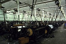
| Queen Street Mill | SD868349 53°48′36″N 2°12′07″W / 53.810°N 2.202°W | 1894 | Standing | 127 | |
 |
Notes: The mill was built in 1894. It was powered by a 500hp tandem compound by William Roberts of Nelson. 300 of the original 1138 Harling & Todd and Pemberton Lancashire looms are still in situ and workable. Now a textile museum run by Lancashire Museums (closed to the public from 30 September 2016).[42] | ||||
| Siberia Mill | 53°48′45″N 2°12′18″W / 53.8124°N 2.2051°W | ||||
 |
Notes: Now industrial units occupy the weaving shed. | ||||
| Walshaw Mill | 53°48′37″N 2°12′22″W / 53.8103°N 2.2062°W | ||||
| Notes: This was the second 20th-century mill; it faces Talbot Street. It was incorporated 5 January 1905. It was financed with 12000 £1 shares and recapitalised later with an additional 30000. It started with 586 looms which was subsequently increased. It now is used by a pharmaceutical distribution company. [41] | |||||
Haslingden and Helmshore[]
Home of S.S.Stott and Co and Helmshore Mills Textile Museum| Name | Architect | Location | Built | Demolished | Served (Years) |
|---|---|---|---|---|---|
| Albert Mill, Helmshore | SD7721 53°41′13″N 2°20′15″W / 53.6869°N 2.3375°W | ||||
 |
Notes: 1891:James Barlow and Sons, together with Sunny Bank, 7000 spindles[43] | ||||
| Albion Mill, Helmshore | SD7721 53°41′14″N 2°20′04″W / 53.6873°N 2.3344°W | ||||
| Notes: Rawstron and Co, 442 looms in 1891 [43] | |||||
| Bridge End Mill | |||||
| Carr's Mill | |||||
| Duckworth Clough Mill, Haslingden | 53°42′57″N 2°19′13″W / 53.7157°N 2.3202°W | ||||
| Notes: A new chimney was erected in 1916. It weighed 635 tons and contained 108,000 bricks.When it was taken out of cotton it became a timber mill, which closed in 2006 and the site is now housing.[44] | |||||
| Hare Clough Mill | |||||
| Higher Mill | SD777217 53°41′28″N 2°20′20″W / 53.691°N 2.339°W | 1796 | standing | 225 | |
 |
Notes: With Whitaker's Mill forms the Helmshore Mills Textile Museum Grade II listed building[45] Higher Mill was built in 1796 for William Turner. |
||||
| Hope Mill | SD779256 53°43′34″N 2°20′10″W / 53.726°N 2.336°W | ||||
| Irwell Vale Mill | [43] | ||||
| Notes: 1891: Thomas Aitken and Son, 7,500 spindles, 221 and 301; 120 looms, calicoes, belting, fustians, filter cloths and cotton drying felts for paper makers. | |||||
| Middle Mill aka Power Mill | 53°41′14″N 2°20′12″W / 53.6871°N 2.3368°W | ||||
 |
Notes: Attacked by Luddite rioters in 1826 1891:Middle Mill Manufacturing Co, Limited, 600 looms.[43] |
||||
| Musbury Mill | 53°41′18″N 2°20′15″W / 53.6883°N 2.3376°W | ||||
 |
Notes: | ||||
| Park Mill, Helmshore | 53°41′19″N 2°20′16″W / 53.6886°N 2.3377°W | ||||
 |
Notes: In 1891, Worsley, Haworth and Law, 2,800 spindles, 38/108 counts ; 78 looms, waste twills and sheetings.[43] | ||||
| Rising Bridge Mill | SD782256 53°43′34″N 2°19′55″W / 53.726°N 2.332°W | ||||
| Sunny Bank Mill | 53°40′49″N 2°20′08″W / 53.6804°N 2.3355°W | ||||
| Notes: 1891:James Barlow and Sons, together with Albert Mill, 7000 spindles [43] | |||||
| Syke Mill | |||||
| Tanpits Mill | |||||
| Whitaker's Mill, Helmshore | SD777217 53°41′28″N 2°20′20″W / 53.691°N 2.339°W | 1820s | standing | ||
 |
Notes: With Higher Mill forms the Helmshore Mills Textile Museum. Whitaker Mill was built in the 1820s by the Turner family.[46] In their early life they alternated between working wool and cotton. By 1920 they were working shoddy as condensor mule mills; and equipment has been preserved and is still used. |
||||
Hoghton[]
| Name | Architect | Location | Built | Demolished | Served (Years) |
|---|---|---|---|---|---|
| Higher Mill | SD628265 53°44′02″N 2°33′54″W / 53.734°N 2.565°W | ||||
| Lower Mill | SD627272 53°44′24″N 2°34′01″W / 53.740°N 2.567°W | ||||
Kirkham[]
| Name | Architect | Location | Built | Demolished | Served (Years) |
|---|---|---|---|---|---|
| Kirkham Linen Mill | SD424323 53°47′02″N 2°52′34″W / 53.784°N 2.876°W | ||||
Nelson[]
| Name | Architect | Location | Built | Demolished | Served (Years) |
|---|---|---|---|---|---|
| Albert Mills | SD859383 53°50′28″N 2°12′58″W / 53.841°N 2.216°W | ||||
| Notes: Croasdale Brothers, 352 looms, Hartley and Co, 780 looms ; Thornton and Co, 258 looms | |||||
| Bradley Corn Mill (Cotton) | |||||
| Clover Mill | |||||
| Dale Shed | SD870382 53°50′24″N 2°11′56″W / 53.840°N 2.199°W | ||||
| Marsden Mill | |||||
| Oak Bank Mill | SD870382 53°50′24″N 2°11′56″W / 53.840°N 2.199°W | ||||
| Hendon Mill | SD870382 53°50′24″N 2°11′56″W / 53.840°N 2.199°W | ||||
| Glenfield Mill | SD870382 53°50′24″N 2°11′56″W / 53.840°N 2.199°W | ||||
| Laurel Bank Mill | |||||
| Lomeshaye Mill | SD851377 53°50′06″N 2°13′41″W / 53.835°N 2.228°W | ||||
| Notes: 1891 - William Ecroyd and Sons, 1,940 looms | |||||
| Lomeshaye Bridge Mill | SD853377 53°50′06″N 2°13′30″W / 53.835°N 2.225°W | ||||
 |
Notes: 1891 - Lomeshaye Bridge Mill Co, 1,305 looms | ||||
| Malvern Mill | SD870382 53°50′24″N 2°11′56″W / 53.840°N 2.199°W | ||||
| Manor Mill | SD870382 53°50′24″N 2°11′56″W / 53.840°N 2.199°W | ||||
| Pendle Street Shed | |||||
 |
Notes: 1891-F. Wilkinson and Co Ltd, 746 looms ; J. H. Wilson and Co, 513 looms | ||||
| Reedyford Mill | 2014 | ||||
| Seed Hill Mill | SD857381 53°50′20″N 2°13′08″W / 53.839°N 2.219°W | ||||
| Notes: 1891-Nelson Manufacturing Co, Limited, 428 looms | |||||
| Spring Bank Mill | SD852375 53°50′02″N 2°13′34″W / 53.834°N 2.226°W | ||||
 |
Notes: | ||||
| Throstle Nest Mill | Leeds Rd 53°50′22″N 2°12′34″W / 53.8395°N 2.2095°W | ||||
 |
Notes: 1891 - Tunstill Brothers | ||||
| Vale Street Shed | SD866375 53°50′02″N 2°12′18″W / 53.834°N 2.205°W | ||||
| Notes: 1891 - James Nelson, together with Whitefield Sheds, 616 looms ; Thomas Stuttard and Co, 110 looms; James Tattersall and Sons, 200 looms ; Taylor and Dean, 295 looms | |||||
| Valley Mills | SD868372 53°49′52″N 2°12′07″W / 53.831°N 2.202°W | ||||
 |
Notes: | ||||
| Victoria Mills | SD861379 53°50′13″N 2°12′47″W / 53.837°N 2.213°W | ||||
| Notes: 1891 - W. and J. Ratcliffe, 150 looms | |||||
| Walverden Mill | SD862376 53°50′02″N 2°12′40″W / 53.834°N 2.211°W | ||||
| Notes: 1891 - J. and E. B. Riley, 150 looms; Samuel Smith, 20 looms ; Walton and Dyson, 61 looms ; Worthington and Wilkinson, 600 looms ; Peter Watson, and Co, 70 looms | |||||
| Whitefield Mill | St Mary's St SD853378 53°50′14″N 2°13′25″W / 53.8371°N 2.2236°W | ||||
 |
Notes: 1891 - William Whitaker, 859 looms 2017- Double Glazing installers |
||||
| [47] | |||||
Oswaldtwistle and Stanhill[]
Home to James Hargreaves
| Name | Architect | Location | Built | Demolished | Served (Years) |
|---|---|---|---|---|---|
| Moscow Mills | SD744280 53°44′53″N 2°23′24″W / 53.748°N 2.390°W | ||||
| Foxhill Bank Printworks | SD741282 53°45′00″N 2°23′38″W / 53.750°N 2.394°W | ||||
| Stanhill Ring Spinning Mill | SD730282 53°44′56″N 2°24′40″W / 53.749°N 2.411°W | ||||
| Vine Mills | SD732272 53°44′24″N 2°24′29″W / 53.740°N 2.408°W | ||||
 |
Notes: | ||||
| Brookside Printworks | SD722272 53°44′24″N 2°25′23″W / 53.740°N 2.423°W | ||||
| Cabin End Mill | SD722272 53°44′24″N 2°25′23″W / 53.740°N 2.423°W | ||||
| Fern Mill | SD721266 53°44′06″N 2°25′26″W / 53.735°N 2.424°W | ||||
| [48] | |||||
Padiham[]
| Name | Architect | Location | Built | Demolished | Served (Years) |
|---|---|---|---|---|---|
| Albert Mill | Wyre Street | ||||
 |
Notes: | ||||
| Albion Mill (Perseverance Mill) | |||||
| Notes: Edward Briggs and Co (together with Bridge End Mill), 26,300 spindles | |||||
| Britannia Mill | SD796339 53°48′04″N 2°18′40″W / 53.801°N 2.311°W | ||||
| Notes: R. Thompson and Sons (together with Alma Mill), 40,000 spindles and 987 looms | |||||
| Grove Mill | Grove Lane | ||||
 |
Notes: | ||||
| Jubilee Mill | SD797333 53°47′46″N 2°18′36″W / 53.796°N 2.310°W | ||||
 |
Notes: Greenbrook Manufacturing, 800 looms | ||||
| Riverside Mill | SD79633953°48′04″N 2°18′29″W / 53.801°N 2.308°W | ||||
 |
Notes: 1891- William Ingham & Sons (together with Albert St Mill), 15,000 spindles, 1322 looms | ||||
| Stockbridge Mill | Stockbridge Road SD794336 53°47′54″N 2°18′44″W / 53.7982°N 2.3123°W | ||||
 |
Notes: | ||||
| Thompson Street Sheds | SD796334 53°47′49″N 2°18′40″W / 53.797°N 2.311°W | ||||
| Victoria Mill | |||||
 |
Notes: 1891-Padiham Spinning Co, 30,000 spindles | ||||
| Wellington Mill | Ribble Street 53°48′00″N 2°18′43″W / 53.800°N 2.312°W | ||||
 |
Notes: 1891-John Whittaker and Son, 36,270 spindles and 654 looms 2011-Glassworks |
||||
Preston[]
| Name | Architect | Location | Built | Demolished | Served (Years) |
|---|---|---|---|---|---|
| Pitt Street Mill | SD534294 53°45′32″N 2°42′29″W / 53.759°N 2.708°W | ||||
| Notes: 1891 - William Entwisle's Sons, Caledonian Mill, Pitt street, 437 looms | |||||
| Hanover Mill | SD533299 53°45′47″N 2°42′36″W / 53.763°N 2.710°W | ||||
| Notes: 1891 - Birley Brothers, 46,466 spindles | |||||
| Fylde Road Mill | SD530300 53°45′50″N 2°42′50″W / 53.764°N 2.714°W | ||||
| Notes: 1891 - Joseph Eccles and Co, Steam Mill, 548 looms | |||||
| Arkwright Mill | SD532302 53°45′58″N 2°42′40″W / 53.766°N 2.711°W | ||||
| Notes: 1891 - Daniel Arkwright, 36,248 spindles | |||||
| Aqueduct Street Mill | SD529304 53°46′05″N 2°42′58″W / 53.768°N 2.716°W | ||||
 |
Notes: 1891 - William Calvert and Co, India Mill, New Hall lane; Aqueduct Mill and Flats Mills, Walton-le-dale, 150,566 spindles | ||||
| Brookhouse Mill | 53°46′03″N 2°43′12″W / 53.7675°N 2.7199°W | ||||
 |
Notes: 1891 - John and Adam Leigh, 40,520 spindles | ||||
| Shelley Road Mill | SD525303 53°46′01″N 2°43′19″W / 53.767°N 2.722°W | ||||
| Notes: 1891 - Hartley Brothers, 42,560 spindles | |||||
| Tulketh Road Mill | SD524309 53°46′19″N 2°43′26″W / 53.772°N 2.724°W | ||||
| Embroidery Mill | |||||
| Red Scar Mill | SD525306 53°46′12″N 2°43′19″W / 53.770°N 2.722°W | ||||
| Notes: 1939 | |||||
| Stocksbridge Mill | SD525306 53°46′12″N 2°43′19″W / 53.770°N 2.722°W | ||||
| Brookfield Mill | SD538305 53°46′08″N 2°42′07″W / 53.769°N 2.702°W | ||||
| Notes: John Goodair and Co, Brookfield and Peel Mills, 73,951 spindles | |||||
| St Georges Road Mill | SD539306 53°46′12″N 2°42′04″W / 53.770°N 2.701°W | ||||
| Notes: 1891 - Moor Park Manufacturing Co Ltd, 600 looms | |||||
| Centenary Mill | SD551297 53°45′43″N 2°40′59″W / 53.762°N 2.683°W | ||||
 |
Notes: | ||||
| Hartford Mill | SD551298 53°45′47″N 2°40′59″W / 53.763°N 2.683°W | ||||
| Notes: 1891 - Hartford Mills Co Ltd, 43,472 spindles | |||||
| Cliff Mill | SD557297 53°45′43″N 2°40′23″W / 53.762°N 2.673°W | ||||
| Manchester Mill | 53°45′46″N 2°40′50″W / 53.7627°N 2.6806°W | ||||
 |
Notes: | ||||
| Primrose Mill | 53°45′33″N 2°41′01″W / 53.7593°N 2.6837°W | ||||
 |
Notes: | ||||
| [49] | |||||
Ramsbottom[]
| Name | Architect | Location | Built | Demolished | Served (Years) |
|---|---|---|---|---|---|
| Four Acre Mill | SD828175 53°39′14″N 2°15′43″W / 53.654°N 2.262°W | ||||
| Cheesden Lumb Mills | SD824162 53°38′31″N 2°16′05″W / 53.642°N 2.268°W | ||||
| Croston Close Upper Mill | SD824162 53°38′31″N 2°16′05″W / 53.642°N 2.268°W | ||||
| Croston Close Lower Mill | SD824162 53°38′31″N 2°16′05″W / 53.642°N 2.268°W | ||||
| Longland Mill | SD823153 53°38′02″N 2°16′08″W / 53.634°N 2.269°W | ||||
| Cobhurst Nab Mill | SD823153 53°38′02″N 2°16′08″W / 53.634°N 2.269°W | ||||
| Deeply Vale Print Works | SD823153 53°38′02″N 2°16′08″W / 53.634°N 2.269°W | ||||
| Lower Wheel Mill | SD829142 53°37′26″N 2°15′36″W / 53.624°N 2.260°W | ||||
| Lee Hill Bleachworks | SD805175 53°39′14″N 2°17′49″W / 53.654°N 2.297°W | ||||
| [50] | |||||
Rawtenstall[]
| Name | Architect | Location | Built | Demolished | Served (Years) |
|---|---|---|---|---|---|
| Cowpe Mill | Boarsgreave 53°40′52″N 2°14′38″W / 53.681°N 2.244°W | ||||
 |
Notes: | ||||
| Rawtenstall Lower Mill | SD811228 53°42′04″N 2°17′17″W / 53.701°N 2.288°W | ||||
| Hardman's Mill | 53°41′48″N 2°17′51″W / 53.6968°N 2.2974°W | ||||
 |
Notes: Grade II listed building[51] | ||||
| Holmes Mill, Reeds Holme | SD808244 53°42′58″N 2°17′31″W / 53.716°N 2.292°W | ||||
| Holmes Shed | SD808244 53°42′58″N 2°17′31″W / 53.716°N 2.292°W | ||||
| Kearns Mill | Boarsgreave 53°40′52″N 2°14′38″W / 53.681°N 2.244°W | ||||
 |
Notes: To be demolished | ||||
| Reedsholmes Mill | SD808244 53°42′58″N 2°17′31″W / 53.716°N 2.292°W | ||||
| Lower Laund Mill | |||||
| Notes: Grade II listed building[52] | |||||
| Sunnyside Printworks | SD811249 53°43′12″N 2°17′17″W / 53.720°N 2.288°W | ||||
| Love Clough Printworks | SD810272 53°44′28″N 2°17′24″W / 53.741°N 2.290°W | ||||
| Hall Carr Mill (Greenbridge Works) | SD817226 53°42′00″N 2°16′44″W / 53.700°N 2.279°W | ||||
 |
Notes: Grade II listed building[53] | ||||
| Baltic Mill | SD833219 53°41′35″N 2°15′14″W / 53.693°N 2.254°W | ||||
| Holt Mill (felt) | |||||
| Bridge End Mill (felt) | |||||
| Gaghills Mill | SD836221 53°41′42″N 2°15′00″W / 53.695°N 2.250°W | ||||
| Globe Mill | SD827225 53°41′56″N 2°15′50″W / 53.699°N 2.264°W | ||||
| Ilex Mill | 53°42′04″N 2°16′59″W / 53.701°N 2.283°W | ||||
 |
Notes: Grade II listed building[54] | ||||
| Dale Mills | |||||
| Clark Holme Mill | |||||
| Shawclough Mill | SD841233 53°42′22″N 2°14′31″W / 53.706°N 2.242°W | ||||
| Shawclough Lower Mill | |||||
| Osborne Mill | SD835238 53°42′36″N 2°15′04″W / 53.710°N 2.251°W | ||||
| Sagar Hole Mill | |||||
| Isle of Man Mill | |||||
 |
Notes: | ||||
| [55] | |||||
Rishton[]
| Name | Architect | Location | Built | Demolished | Served (Years) |
|---|---|---|---|---|---|
| Unity Mill | SD727308 53°46′23″N 2°24′58″W / 53.773°N 2.416°W | ||||
| Britannia Mill | |||||
| Bridgefield Mill | |||||
| Albert Mill | SD726305 53°46′12″N 2°25′01″W / 53.770°N 2.417°W | ||||
| York Mill | SD726305 53°46′12″N 2°25′01″W / 53.770°N 2.417°W | ||||
| [56] | |||||
Sabden[]
| Name | Architect | Location | Built | Demolished | Served (Years) |
|---|---|---|---|---|---|
| Sabden Printworks | SD772370 53°49′44″N 2°20′53″W / 53.829°N 2.348°W | ||||
| Victoria Mill | |||||
 |
Notes: | ||||
| Cobden Mill | |||||
Samlesbury[]
| Name | Architect | Location | Built | Demolished | Served (Years) |
|---|---|---|---|---|---|
| Samlesbury Bottoms Mill | SD619289 53°45′18″N 2°34′44″W / 53.755°N 2.579°W | ||||
| Roach Bridge Mill | SD596288 53°45′14″N 2°36′50″W / 53.754°N 2.614°W | ||||
Trawden[]
| Name | Architect | Location | Built | Demolished | Served (Years) |
|---|---|---|---|---|---|
| Black Carr Mills | SD912390 53°50′49″N 2°08′06″W / 53.847°N 2.135°W | ||||
|
Notes: CRS Plant Ltd | ||||
| Forest Shed | SD912390 53°50′49″N 2°08′06″W / 53.847°N 2.135°W | ||||
| [57] | |||||
Walton le Dale[]
| Name | Architect | Location | Built | Demolished | Served (Years) |
|---|---|---|---|---|---|
| Bamber Bridge Mill | SD566255 53°43′26″N 2°39′32″W / 53.724°N 2.659°W | ||||
 |
Notes: | ||||
| Higher Walton Mill | SD554284 53°45′00″N 2°40′41″W / 53.750°N 2.678°W | ||||
 |
Notes: 1891: George and R. Dewhurst, 77,288 spindles, 308 twist and weft; 1,168 looms [58] | ||||
| Penwortham Mill | Penwortham SD540273 53°44′24″N 2°41′56″W / 53.740°N 2.699°W | ||||
 |
Notes: 1891: Josiah Cockshutt, 25,000 spindles [58] | ||||
Whalley[]
| Name | Architect | Location | Built | Demolished | Served (Years) |
|---|---|---|---|---|---|
| Abbey Mills | SD733360 53°49′12″N 2°24′25″W / 53.820°N 2.407°W | ||||
Whitworth[]
| Name | Architect | Location | Built | Demolished | Served (Years) |
|---|---|---|---|---|---|
| Albert Mill | Market Street | 1882 | 2017 | 135 | |
 |
Notes: 1891-Whitworth Manufacturing Co, 28,080 spindles, 651 looms | ||||
| Bridge Mill | SD884182 53°39′36″N 2°10′37″W / 53.660°N 2.177°W | ||||
| Notes: 1891-Matthew Stuttard and Brothers Ltd | |||||
| Bridge End Mills | |||||
| Notes: 1891-John Hargreaves and Sons, Ltd, 38,000 spindles, 662 looms | |||||
| Brookside Mill | SD884182 53°39′36″N 2°10′37″W / 53.660°N 2.177°W | ||||
| Dora Mill | SD884182 53°39′36″N 2°10′37″W / 53.660°N 2.177°W | ||||
| Facit Mill | SD889190 53°40′01″N 2°10′08″W / 53.667°N 2.169°W | 1904 | 2012 | 108 | |
 |
Notes: 1891-John Whitworth and Sons, Limited, 25,000 spindles, 720 looms (previous mill that occupied the site) | ||||
| Orama Mill | SD883178 53°39′25″N 2°10′44″W / 53.657°N 2.179°W | ||||
| Underbank Mills | |||||
| Notes: 1891-Matthew Stuttard and Brothers Ltd, 20,000 spindles, 420 looms | |||||
| [59] | |||||
Withnell[]
| Name | Architect | Location | Built | Demolished | Served (Years) |
|---|---|---|---|---|---|
| Abbey Mill | SD640225 53°41′53″N 2°32′49″W / 53.698°N 2.547°W | ||||
 |
Notes: 1891-John Park and Son, 22,500 spindles and 400 looms | ||||
| Brinscall Hall Printworks | SD623205 53°40′48″N 2°34′19″W / 53.680°N 2.572°W | ||||
See also[]
- List of mills in Greater Manchester, for other mills historically in Lancashire
- Category:Lists of textile mills in the United Kingdom
- List of mills owned by the Lancashire Cotton Corporation Limited
References[]
- ^ Jump up to: a b c d e f g h i "1891 Cotton Mills in Accrington, Church and Oswaldtwistle". www.gracesguide.co.uk. Archived from the original on 4 March 2016. Retrieved 24 April 2018.
- ^ Ashmore 1982, pp. 179, 180
- ^ "Name: BROADCLOUGH MILL List entry Number: 1163200". Historic England. Archived from the original on 16 April 2016. Retrieved 1 March 2016.
- ^ "Name: STACKSTEADS MILL List entry Number: 1072832". Historic England. Archived from the original on 4 October 2015. Retrieved 1 March 2016.
- ^ "Name: WATERSIDE MILL List entry Number: 1072860". Historic England. Archived from the original on 4 October 2015. Retrieved 1 March 2016.
- ^ Ashmore 1982, pp. 182, 183
- ^ Ashmore 1982, p. 184
- ^ Graham 2008, pp. 7, 8.
- ^ Jump up to: a b c d Graham 2008, p. 7.
- ^ Bentley, John; Bond; Gill (2005), Ingleton Coalfield, Northern Mine Research Society, p. 65, ISBN 978-0-901450-58-6
- ^ Ashmore 1982, p. 185
- ^ Ashmore 1982, pp. 187, 189
- ^ "Name: BRIERFIELD MILLS List entry Number: 1073407". Historic England. Archived from the original on 2 March 2016. Retrieved 29 February 2016.
- ^ "Name: VICTORIA MILL List entry Number: 1313388". Historic England. Archived from the original on 25 April 2016. Retrieved 22 April 2016.
- ^ "Name: BELLE VUE MILL List entry Number: 1313392". Historic England online. Archived from the original on 24 April 2016. Retrieved 22 April 2016.
- ^ Ashmore 1982, pp. 190, 193
- ^ http://www.gracesguide.co.uk/1891_Cotton_Mills_in_Burnley#Burnley_.28p73.29 Archived 2016-05-04 at the Wayback Machine Graces Guide 1891
- ^ "Name: Kirk Mill and its associated mill ponds retaining walls, outflow and stone-built leat List entry Number: 1401593". Historic England. Archived from the original on 2 March 2016. Retrieved 29 February 2016.
- ^ Dowd, Adrian (4 Feb 2010). "Proposed Kirk Mill Conservation Area" (PDF). Ribble Valley Borough Council. Archived from the original on 2 June 2009. Retrieved 3 April 2013.
- ^ Cooper 1983, pp. 49, 95.
- ^ "Chorley Historical and Archaeological Society". www.chorleyhistorysociety.co.uk. Archived from the original on 20 November 2015. Retrieved 24 April 2018.
- ^ "Our History - Botany Bay". botanybay.co.uk. Archived from the original on 2 September 2017. Retrieved 24 April 2018.
- ^ "Jobs in balance at carpet company". Chorley Guardian. Archived from the original on 2017-08-04.
- ^ "Archived copy". Archived from the original on 2015-03-29. Retrieved 2015-11-13.CS1 maint: archived copy as title (link)
- ^ "Archived copy" (PDF). Archived from the original (PDF) on 2012-08-16. Retrieved 2014-12-12.CS1 maint: archived copy as title (link)
- ^ Ashmore 1982, pp. 195, 196
- ^ Jump up to: a b "Bid to save iconic Colne mills from demolition". Lancashire Telegraph. Archived from the original on 24 April 2018. Retrieved 24 April 2018.
- ^ "Historic Colne mill to be demolished?". pendletoday.co.uk. Archived from the original on 16 April 2013. Retrieved 24 April 2018.
- ^ Colne_Waterside Archived 2009-06-02 at WebCite
- ^ Ashmore 1982, p. 198
- ^ "Name: COPPULL RING MILL List entry Number: 1362173". Historic England. Archived from the original on 2 March 2016. Retrieved 29 February 2016.
- ^ "Name: INDIA MILL List entry Number: 1072436". Historic England. Archived from the original on 2 March 2016. Retrieved 29 February 2016.
- ^ "Name: INDIA MILL CHIMNEY List entry Number: 1362166". Historic England. Archived from the original on 2 March 2016. Retrieved 29 February 2016.
- ^ Ashmore 1982, pp. 199, 201
- ^ "1891 Cotton Mills in Darwen". www.gracesguide.co.uk. Archived from the original on 11 May 2017. Retrieved 24 April 2018.
- ^ Jump up to: a b Ashmore 1982, p. 203.
- ^ https://www.great-harwood.org.uk/about/History/Industry/Cotton/millmap.htm[bare URL]
- ^ Ashmore 1982, pp. 205, 206
- ^ Bythell & Frost 2009, p. 32.
- ^ Bythell & Frost 2009, pp. 10, .
- ^ Jump up to: a b Bythell & Frost 2009, p. 37.
- ^ Queen Street Mill
- ^ Jump up to: a b c d e f "1891 Cotton Mills in Haslingden". www.gracesguide.co.uk. Archived from the original on 19 September 2008. Retrieved 24 April 2018.
- ^ Yorke, Bryan (17 April 2009). "Haslingden Old and New...: Duckworth Clough Mill..." haslingdens.blogspot.com. Archived from the original on 4 March 2016. Retrieved 24 April 2018.
- ^ "Name: HIGHER MILL MUSEUM List entry Number: 1072811". Historic England. Archived from the original on 11 March 2016. Retrieved 1 March 2016.
- ^ Helmshore[permanent dead link]
- ^ Ashmore 1982, pp. 211, 213
- ^ Ashmore 1982, p. 214
- ^ Ashmore 1982, pp. 217, 219
- ^ Ashmore 1982, p. 221
- ^ "Name: HARDMAN'S MILL List entry Number: 1164157". Historic England. Archived from the original on 1 December 2017. Retrieved 1 March 2016.
- ^ "Name: LOWER LAUND MILL List entry Number: 1318019". Historic England. Archived from the original on 24 April 2018. Retrieved 1 March 2016.
- ^ "Name: GREENBRIDGE WORKS List entry Number: 1361961". Historic England. Archived from the original on 1 December 2017. Retrieved 1 March 2016.
- ^ "Name: ILEX MILL List entry Number: 1072788". Historic England. Archived from the original on 1 December 2017. Retrieved 1 March 2016.
- ^ Ashmore 1982, p. 222
- ^ Ashmore 1982, p. 224
- ^ Ashmore 1982, p. 225
- ^ Jump up to: a b "1891 Cotton Mills in Preston - Graces Guide".
- ^ Ashmore 1982, p. 229
Bibliography[]
- Ashmore, Owen (1982). The industrial archaeology of North-west England. Manchester University Press. ISBN 0-7190-0820-4. Retrieved 2009-06-25.
- Bythell, Duncan; Frost (2009). A Lancashire weaving company and its community: Harle Syke Mill. Harle Syke, Burnley, Lancashire: The Briercliffe Society. ISBN 978-0-9553100-8-9.
External links[]
 Media related to Textile mills in Lancashire at Wikimedia Commons

- Textile mills in Lancashire
- Lists of textile mills in the United Kingdom
- Former textile mills in the United Kingdom
- History of Lancashire
- Lists of buildings and structures in Lancashire