List of mountains on Io
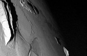
More than 135 mountains have been identified on the surface of Jupiter's moon Io.[1] Despite the extensive active volcanism taking place on Io, most mountains on Io are formed through tectonic processes. These structures average 6 km (4 mi) in height and reach a maximum of 17.5 ± 1.5 km (10.9 ± 1 mi) at South Boösaule Montes.[2] Mountains often appear as large (the average mountain is 157 km (98 mi) long), isolated structures with no apparent global tectonic patterns outlined, in contrast to the situation on Earth.[2] To support the tremendous topography observed at these mountains requires rock compositions consisting mostly of silicate, as opposed to sulfur.[3]
Mountains on Io (generally, structures rising above the surrounding plains) have a variety of morphologies. Plateaus are most common.[2] These structures resemble large, flat-topped mesas with rugged surfaces. Other mountains appear to be tilted crustal blocks, with a shallow slope from the formerly flat surface and a steep slope consisting of formerly sub-surface materials uplifted by compressive stresses. Both types of mountains often have steep scarps along one or more margins. Only a handful of mountains on Io appear to have a volcanic origin. These mountains resemble small shield volcanoes, with steep slopes (6–7°) near a small, central caldera and shallow slopes along their margins.[4] These volcanic mountains are often smaller than the average mountain on Io, averaging only 1 to 2 km (0.6 to 1.2 mi) in height and 40 to 60 km (25 to 37 mi) wide. Other shield volcanoes with much shallower slopes are inferred from the morphology of several of Io's volcanoes, where thin flows radiate out from a central patera, such as at Ra Patera.[4]
Some of Io's mountains have received official names from the International Astronomical Union. The names are a combination of a name of a person or place derived from the Greek mythological story of Io, Dante's Inferno, or from the name of a nearby feature on Io surface and an approved descriptive term. The descriptive terms, or categories, used for these mountains depends on their morphology, which is a reflection of the mountain's age, geologic origin (volcanic or tectonic), and mass wasting processes. Mountains consisting of massifs, ridges, or isolated peaks use the descriptive term, mons or the plural montes, the Latin term for mountain. These features are named after prominent locations from the Greek mythological travels of Io or places mentioned in Dante's Inferno.[5] Plateaus are normally given the descriptive term mensa (pl. mensae), the Latin term for mesa, though some mountains with plateau morphology use mons. Ionian mensae are named after mythological figures associated with the Io myth, characters from Dante's Inferno.[5] Like mountains, these features can also be named after nearby volcanoes. Some units of layered plains have names using the descriptive term planum (pl. plana). However other more mountainous structures, such as Danube Planum, use the term. Partly as a result of the inconsistent use of this term, planum has not been used since the Voyager era. Ionian plana are named after locations associated with the Io myth.[5] Rare cases of volcanic mountains, such as the shield volcano Tsũi Goab Tholus, use the term tholus (plural: tholi). Ionian tholi are named after people associated with the Io myth or nearby features on Io's surface.[5]
See also the list of volcanic features on Io and the list of regions on Io.
List of named Ionian mountains[]
The following table lists those positive topographic structures (mountains, plateaus, shield volcanoes, and layered plains) that have been given names by the International Astronomical Union.[6] Coordinates and Length come from the USGS website that hosts that nomenclature list. Height information from Paul Schenk's 2001 paper, "The mountains of Io: Global and geological perspectives from Voyager and Galileo".[2] When the name refers to multiple mountains, the tallest peak from Schenk et al. 2001 is listed. Those whose heights come from another sources are noted and sourced in the table. Height ranges result from uncertainties due to different methods used to determine the height of the mountain.

See also[]
- List of mountains
- List of mountain types
- Category:Lists of mountains
- List of mountain ranges
- List of highest mountains
- List of peaks by prominence
- List of tallest mountains in the Solar System
- Mountaineering
References[]
- ^ a b c d Turtle, Elizabeth P.; et al. (2007). "Appendix 2: Ionian mountains identified to date". In Lopes, R. M. C.; Spencer, J. R. (eds.). Io after Galileo. Springer-Praxis. pp. 325–330. ISBN 3-540-34681-3.
- ^ a b c d Schenk, P.; et al. (2001). "The Mountains of Io: Global and Geological Perspectives from Voyager and Galileo". Journal of Geophysical Research. 106 (E12): 33201–33222. Bibcode:2001JGR...10633201S. doi:10.1029/2000JE001408.
- ^ Clow, G. D.; Carr, M. H. (1980). "Stability of sulfur slopes on Io". Icarus. 44 (2): 268–279. Bibcode:1980Icar...44..268C. doi:10.1016/0019-1035(80)90022-6.
- ^ a b c Schenk, P. M.; et al. (2004). "Shield volcano topography and the rheology of lava flows on Io". Icarus. 169: 98–110. Bibcode:2004Icar..169...98S. doi:10.1016/j.icarus.2004.01.015.
- ^ a b c d Blue, Jennifer (October 16, 2006). "Categories for Naming Features on Planets and Satellites". USGS. Retrieved 2010-01-17.
- ^ Blue, Jennifer. "Io Nomenclature Table Of Contents". USGS. Retrieved 2010-01-17.
External links[]
- USGS: Io nomenclature
- USGS: Io nomenclature: mountains
- Io's Tall Mountains – Planetary Society article
- Io Mountain Database, including those without official names
| Main articles |    | ||||||||||||||
|---|---|---|---|---|---|---|---|---|---|---|---|---|---|---|---|
| Geology |
| ||||||||||||||
| Exploration |
| ||||||||||||||
- Lists of extraterrestrial mountains
- Mountains on Io (moon)