List of municipalities of the Brussels-Capital Region
| Politics and government of Brussels |
|---|
 |
The 19 municipalities of the Brussels-Capital Region[1][2] (French: Région de Bruxelles-Capitale, Dutch: Brussels Hoofdstedelijk Gewest) are the political subdivisions of Belgium's central region.[3] The government of each municipality is responsible for the handling of local level duties, such as law enforcement and the upkeep of schools and roads within its borders.[4] Municipal administration is also conducted by a mayor, a council, and an executive.[4]
In 1831, Belgium was divided into 2,739 municipalities, including the 19 in the Brussels-Capital Region (which at that time did not exist).[5] Unlike most of the municipalities in Belgium, the ones located in the Brussels-Capital Region were not merged with others during mergers occurring in 1964, 1970, and 1975.[5] However, several municipalities outside of the Brussels-Capital Region have been merged with the City of Brussels throughout its history including Laken, Haren, and Neder-Over-Heembeek, which were merged into the City of Brussels in 1921.[6]
The largest and most populous of the municipalities is the City of Brussels, covering 32.6 square kilometres (12.6 sq mi) with 176,545 inhabitants. The least populous is Koekelberg with 21,609 inhabitants, and the smallest in area is Saint-Josse-ten-Noode, which is only 1.1 square kilometres (0.4 sq mi) and also has the highest population density of the 19 with 24,650 inhabitants per km². Watermael-Boitsfort has the lowest population density, at 1,928 per km².
List[]
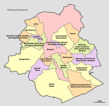
The names of the municipalities are given in the two official languages of the Brussels-Capital Region: French and Dutch. The numbers in the "#" row refer to the map above.
| French name | Dutch name | Flag | CoA | post code |
Population (1/1/2017) |
Area | Population density (km²) |
Ref. | |
|---|---|---|---|---|---|---|---|---|---|
| 1 | Anderlecht | Anderlecht | 1070 | 118,241 | 17.7 km2 (6.8 sq mi) | 6,680 | [7] | ||
| 2 | Auderghem | Oudergem | 1160 | 33,313 | 9.0 km2 (3.5 sq mi) | 3,701 | [8] | ||
| 3 | Berchem-Sainte-Agathe | Sint-Agatha-Berchem | 1082 | 24,701 | 2.9 km2 (1.1 sq mi) | 8,518 | [9] | ||
| 4 | Ville de Bruxelles* | Stad Brussel* | 1000 1020 1030 1040 1050 1120 1130 |
176,545 | 32.6 km2 (12.6 sq mi) | 5,415 | [10] | ||
| 5 | Etterbeek | Etterbeek | 1040 | 47,414 | 3.1 km2 (1.2 sq mi) | 15,295 | [11] | ||
| 6 | Evere | Evere | 1140 | 40,394 | 5.0 km2 (1.9 sq mi) | 8,079 | [12] | ||
| 7 | Forest | Vorst | 1190 | 55,746 | 6.2 km2 (2.4 sq mi) | 8,991 | [13] | ||
| 8 | Ganshoren | Ganshoren | 1083 | 24,596 | 2.5 km2 (1.0 sq mi) | 9,838 | [14] | ||
| 9 | Ixelles | Elsene | 1050 | 86,244 | 6.3 km2 (2.4 sq mi) | 13,690 | [15] | ||
| 10 | Jette | Jette | 1090 | 51,933 | 5.0 km2 (1.9 sq mi) | 10,387 | [16] | ||
| 11 | Koekelberg | Koekelberg | 1081 | 21,609 | 1.2 km2 (0.5 sq mi) | 18,008 | [17] | ||
| 12 | Molenbeek-Saint-Jean | Sint-Jans-Molenbeek | 1080 | 96,629 | 5.9 km2 (2.3 sq mi) | 16,378 | [18] | ||
| 13 | Saint-Gilles | Sint-Gillis | 1060 | 50,471 | 2.5 km2 (1.0 sq mi) | 20,188 | [19] | ||
| 14 | Saint-Josse-ten-Noode | Sint-Joost-ten-Node | 1210 | 27,115 | 1.1 km2 (0.4 sq mi) | 24,650 | [20] | ||
| 15 | Schaerbeek | Schaarbeek | 1030 | 133,042 | 8.1 km2 (3.1 sq mi) | 16,425 | [21] | ||
| 16 | Uccle | Ukkel | 1180 | 82,307 | 22.9 km2 (8.8 sq mi) | 3,594 | [22] | ||
| 17 | Watermael-Boitsfort | Watermaal-Bosvoorde | 1170 | 24,871 | 12.9 km2 (5.0 sq mi) | 1,928 | [23] | ||
| 18 | Woluwe-Saint-Lambert | Sint-Lambrechts-Woluwe | 1200 | 55,216 | 7.2 km2 (2.8 sq mi) | 7,669 | [24] | ||
| 19 | Woluwe-Saint-Pierre | Sint-Pieters-Woluwe | 1150 | 41,217 | 8.9 km2 (3.4 sq mi) | 4,631 | [25] |
* — English: “City of Brussels”/“Brussels-City”
See also[]
- List of municipalities of Belgium
- Municipalities with language facilities
References[]
- ^ "The Belgian Constitution (English version)" (PDF). Belgian House of Representatives. January 2009. Archived from the original (PDF) on 2011-07-06. Retrieved 2009-06-05.
Article 3: Belgium comprises three Regions: the Flemish Region, the Walloon Region and the Brussels Region. Article 4: Belgium comprises four linguistic regions: the Dutch-speaking region, the French speaking region, the bilingual region of Brussels-Capital and the German-speaking region.
- ^ "Brussels-Capital Region: Creation". Centre d'Informatique pour la Région Bruxelloise (Brussels Regional Informatics Center). 2009. Archived from the original on 29 April 2009. Retrieved 2009-06-05.
Since 18 June 1989, the date of the first regional elections, the Brussels-Capital Region has been an autonomous region comparable to the Flemish and Walloon Regions.
(All text and all but one graphic show the English name as Brussels-Capital Region.) - ^ "Communes of the Brussels-Capital Region". Centre d'Informatique pour la Région Bruxelloise (Brussels Regional Informatics Center). 2009. Archived from the original on 2004-06-06. Retrieved 2009-04-05.
- ^ Jump up to: a b "Managing across levels of government" (PDF). OECD. 1997. pp. 107, 110. Archived from the original (PDF) on 2008-08-19. Retrieved 2009-04-05.
- ^ Jump up to: a b Picavet, Georges (29 April 2003). "Municipalities (1795-now)". Georges Picavet. Retrieved 2009-04-05.
- ^ "Brussels Capital-Region". Georges Picavet. 4 June 2005. Retrieved 2009-04-05.
- ^ "Anderlecht". CIBG. 2015. Retrieved 2015-11-19.
- ^ "Auderghem/Oudergem". CIBG. 2015. Retrieved 2015-11-19.
- ^ "Berchem-Sainte-Agathe/Sint-Agatha-Berchem". CIBG. 2015. Retrieved 2015-11-19.
- ^ "City of Brussels". CIBG. 2015. Retrieved 2015-11-19.
- ^ "Etterbeek". CIBG. 2015. Retrieved 2015-11-19.
- ^ "Evere". CIBG. 2015. Retrieved 2015-11-19.
- ^ "Forest/Vorst". CIBG. 2015. Retrieved 2015-11-19.
- ^ "Ganshoren". CIBG. 2015. Retrieved 2015-11-19.
- ^ "Ixelles/Elsene". CIBG. 2015. Retrieved 2015-11-19.
- ^ "Jette". CIBG. 2015. Retrieved 2015-11-19.
- ^ "Koekelberg". CIBG. 2015. Retrieved 2015-11-19.
- ^ "Molenbeek-Saint-Jean/Sint-Jans-Molenbeek". CIBG. 2015. Retrieved 2015-11-19.
- ^ "Saint-Gilles/Sint-Gillis". CIBG. 2015. Retrieved 2015-11-19.
- ^ "Saint-Josse-ten-Noode/Sint-Joost-ten-Node". CIBG. 2015. Retrieved 2015-11-19.
- ^ "Schaerbeek/Schaarbeek". CIBG. 2015. Retrieved 2015-11-19.
- ^ "Uccle". CIBG. 2015. Retrieved 2015-11-19.
- ^ "Watermael-Boitsfort/Watermaal-Bosvoorde". CIBG. 2015. Retrieved 2015-11-19.
- ^ "Woluwe-Saint-Lambert/Sint-Lambrechts-Woluwe". CIBG. 2015. Retrieved 2015-11-19.
- ^ "Woluwe-Saint-Pierre/Sint-Pieters-Woluwe". CIBG. 2015. Retrieved 2015-11-19.
External links[]
| Wikimedia Commons has media related to Municipalities in Brussels-Capital Region. |
- Brussels-Capital Region. Centre d'Informatique pour la Région Bruxelloise (Brussels Regional Informatics Center)
- Interactive map of the 19 Communes (Municipalities) of Brussels

- Lists of municipalities of Belgium
- Municipalities of the Brussels-Capital Region