North–South connection
| Brussels North–South connection | ||
|---|---|---|
 The North-South connection (bold black) in relation to other Brussels railway and metro lines | ||
| Overview | ||
| Status | Operational | |
| Locale | Belgium | |
| Termini | Brussels-North railway station Brussels-South railway station | |
| Service | ||
| Operator(s) | National Railway Company of Belgium | |
| History | ||
| Opened | 1952 | |
| Technical | ||
| Line length | 3.8 km (2.4 mi) | |
| Number of tracks | six tracks | |
| Track gauge | 1,435 mm (4 ft 8+1⁄2 in) standard gauge | |
| Electrification | 3 kV DC | |
| ||
The North–South connection (French: Jonction Nord-Midi, Dutch: Noord-Zuidverbinding) is a railway link of national and international importance through the centre of Brussels, Belgium, that connects the major railway stations in the city. It is line 0 (zero) of the Belgian rail network. With 1200 trains a day, it is the busiest railway line in Belgium and the busiest railway tunnel in the world.[1] It has six tracks and is used for passenger trains, or rarely for a maintenance train when work is to be done on the railway infrastructure inside the North-South connection itself, but no freight trains. It is partially underground (around Brussels Central Station) and partially raised above street level.
History[]
Brussels was served by two main railway stations: Brussels North (opened 1846) and Brussels South (opened 1869, replacing a nearby station of 1840). They are located just outside opposite ends of the Pentagon – an area within the ring roads which follow the boundary of the old city walls. Shortly after opening, both stations were handling large volumes of commuter, regional and international passengers, but through journeys required disembarking and a street-level transfer through the city's old town, a distance of over 3 kilometres (2 mi).
The idea of an underground railway line linking the two stations was first suggested in the 1860s as part of a proposal for the covering of the Senne.[2] That proposal was never implemented. The current version was planned before World War II, after a decision originally made in 1909, and it came into service on 5 October 1952.[3][4] Both stations were demolished and reconstructed to allow through services, reopening in 1952.
Three new intermediate stations were constructed along the route to serve the city centre. Two of them, Brussels Chapel and Brussels Congress, were intended stops only for local commuter services and have never been heavily used. The largest of the new stations, Brussels Central, was built to additionally serve regional and international services transiting through Brussels. The combination of a city-centre location and numerous services to diverse destinations led to Brussels Central becoming the busiest station in Belgium.[5] Brussels North, Brussels Central and Brussels South are now the three main railways stations in the city; they are also the three busiest stations in all of Belgium.
Stations[]
The stations on the line, from north to south, are:[6][7]
- Brussels North (French: Bruxelles-Nord (STIB: Gare du Nord), Dutch: Brussel-Noord (MIVB: Noordstation))
- Brussels Congress (French: Bruxelles-Congrès, Dutch: Brussel-Congres)
- Brussels Central (French: Bruxelles-Central (STIB: Gare Centrale), Dutch: Brussel-Centraal (MIVB: Centraal Station))
- Brussels Chapel (French: Bruxelles-Chapelle, Dutch: Brussel-Kapellekerk)
- Brussels South (French: Bruxelles-Midi (STIB: Gare du Midi), Dutch: Brussel-Zuid (MIVB: Zuidstation)) (the Eurostar, Thalys, TGV and ICE international terminal)
The stations of Brussels North and Brussels South are also linked by the premetro north–south axis, which runs through the city centre to the west of the railway line.

Brussels North, taken from one of the platforms 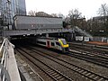
The northern end of the North–South connection tunnel, just south of Brussels North, near the Botanical Garden 
The southern end of the North–South connection tunnel, at Brussels Chapel


Operations[]
All regular national (inter-city and local) trains that use the line stop at North, Central and South stations. The international high-speed Thalys, Eurostar and TGV services stop only at the international terminal of Brussels South. ICEs have an additional stop at Brussels North. Of international trains other than high-speed trains, the only ones left, terminating in Brussels South, are thrice-weekly NightJet sleepers to and from Austria (stopping at South and North) and hourly Benelux trains to and from The Hague or Amsterdam (stopping at South, Central and North stations). Congress and Chapel stations are served twice an hour in each direction, on weekdays only, by a commuters' train on the Antwerp — Nivelles line.[8]
The line is not used by freight trains: the only non-passenger trains allowed on this line are the rare trains performing infrastructure maintenance on the North-South connection itself. To avoid further congestion, all freight traffic crossing between the north and south of Brussels is routed instead along either line 26, to the east (Halle to Vilvoorde, via Merode),[9] or along line 28, to the west (Brussels South to Bockstael railway station via Brussels-West station and Simonis).[10]
Commemoration[]
The North–South connection was selected as the main motif of a very high value collectors' coin: the Belgian 50th Anniversary of the north–south connection commemorative coin, minted in 2002. The obverse front side shows a train coming out of the North–South connection tunnel, it being one of the most famous rail links in Belgium. On the coin is written the words "Noord-Zuidverbinding Jonction Nord-Midi" (North-South connection in Dutch and French) and the years 1952 (representing the opening of the connection) and 2002.
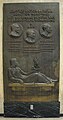
Plaque at Brussels Central commemorating the opening (panel 1) 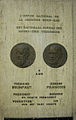
Plaque at Brussels Central commemorating the opening (panel 2) 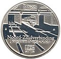
50th Anniversary of the north–south connection commemorative coin


References[]
- ^ "Spoorwegen leggen taboe op tafel (Dutch)". Retrieved 21 January 2009.
- ^ Demey, 49.
- ^ "Ligne 0 : Jonction Nord-Midi" (in French). Retrieved 14 December 2009.
- ^ "Sur la jonction ferroviaire entre Bruxelles-Nord et Bruxelles-Midi" (PDF) (in French). Retrieved 14 December 2009.
- ^ "Gares : Bruxelles-Centrale en tête". La Libre. 10 June 2010. Retrieved 15 June 2011.
- ^ "Back to the fifties". La Libre Belgique (in French). Brussels. 17 April 2008. Retrieved 14 December 2009.
- ^ "Bruxelles Vie Pratique: Transport, Belgique – Guide pour expatriés, Expatriation" (in French). Retrieved 14 December 2009.
- ^ "NMBS Route Planner". Retrieved 1 March 2010.
- ^ "Freight in Brussels-Midi". Archived from the original on 2 April 2012. Retrieved 23 July 2008.
- ^ "Planitram – SNCB – General Information". Retrieved 23 July 2008.
Print sources[]
- (in French) Demey, Thierry. Bruxelles, chronique d’une capitale en chantier, Volume 1. Du voûtement de la Senne à la jonction Nord-Midi, Bruxelles, Paul Legrain/C.F.C.-Editions, 1990
See also[]
- History of rail transport in Belgium
- NMBS/SNCB (the Belgian national railway company)
- Rail transport in Belgium
- Transport in Brussels


- Railway lines in Brussels
- Underground commuter rail
- City of Brussels