List of national parks of Spain

There are fifteen national parks in Spain: ten in the Iberian Peninsula, four in the Canary Islands and one in the Balearic Islands. Twelve of the seventeen autonomous communities of Spain have national parks. Canary Islands has the most (four), followed by Andalusia, Castile-La Mancha and Castile and León (two each). There are five autonomous communities that have no national parks: Basque Country, La Rioja, Murcia, Navarre, Valencian Community.
As of 2017 about 15 million people visited Spanish national parks , with Teide accounting for about 28% of all visitors. The second most visited park was Picos de Europa (17%), followed by Ordesa y Monte Perdido (13%). The least visited parks were Cabrera Archipelago (0.81%) and Cabañeros (0.72%).[1] With more than 2.5 million visitors in 2013, Teide was the most visited national park in Europe that year, and sixth most visited in the world.[2]
National parks[]
| Name | Photo | Province | Autonomous community | Designated | Area | Description | Ref |
|---|---|---|---|---|---|---|---|
| Aigüestortes i Estany de Sant Maurici | 
|
Lleida | Catalonia | 1955 | 14,119 ha (34,889 acres) |
Consists of two valleys (Sant Nicolau and L'Escrita) located between the rivers Noguera Pallaresa and Noguera Ribagorzana. Comaloforno is the highest mountain, with a peak at 3,033 meters (9,951 ft).[3] | [4] |
| Cabañeros | 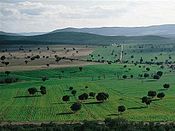
|
Ciudad Real and Toledo | Castile-La Mancha | 1995 | 40,856 ha (100,957 acres) |
Part of the Montes de Toledo system of mountain ranges. Rocigalgo, at about 1,500 meters (4,900 ft), is the highest mountain in the park.[5] | [6] |
| Cabrera Archipelago | 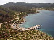
|
Balearic Islands | Balearic Islands | 1991 | 90,800.52 ha (224,373 acres) |
Consists of the Balearic island Cabrera, that was isolated from Majorca during the last glacial period 12,000 years ago, and the surrounding archipelago[needs update].[7] | [8] |
| Caldera de Taburiente | 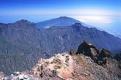
|
Santa Cruz de Tenerife (La Palma island) | Canary Islands | 1954 | 4,690 ha (11,589 acres) |
[9] | |
| Doñana | 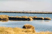
|
Huelva and Sevilla | Andalusia | 1969 | 54,252 ha (134,060 acres) |
[10] | |
| Garajonay | 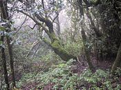
|
Santa Cruz de Tenerife (La Gomera island) | Canary Islands | 1981 | 3,984 ha (9,845 acres) |
[11] | |
| Guadarrama | 
|
Madrid, Segovia and Ávila | Community of Madrid and Castile and León | 2013 | 33,960 ha (83,917 acres) |
[12] | |
| Illas Atlánticas de Galicia | 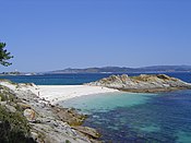
|
A Coruña and Pontevedra | Galicia | 2002 | 8,480 ha (20,955 acres) |
It comprises the archipelagos of Cíes, Ons, Sálvora and Cortegada. The park covers a land area of 1,200 ha (3,000 acres) and a sea area of 7,200 ha (18,000 acres) | [13] |
| Monfragüe | 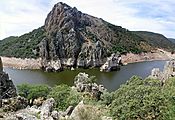
|
Cáceres | Extremadura | 2007 | 18,396 ha (45,458 acres) |
[14] | |
| Ordesa y Monte Perdido | 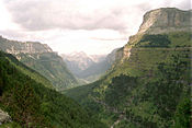
|
Huesca | Aragon | 1918 | 15,608 ha (38,568 acres) |
[15] | |
| Picos de Europa | 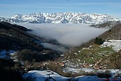
|
Asturias, León and Cantabria | Asturias, Castile-Leon and Cantabria | 1918 | 67,127 ha (165,874 acres) |
Covers the mountain range Picos de Europa (part of the Cantabrian Mountains) and consists of three massifs: Central, Western and Eastern. Torre de Cerredo, at 2,646 meters (8,681 ft), is the highest mountain.[16] | [17] |
| Sierra Nevada | 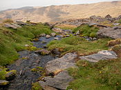
|
Granada, Almería, and Málaga | Andalusia | 1999 | 85,883 ha (212,222 acres) |
The park has fifteen peaks over 3,000 meters (9,800 ft) altitude, including Mulhacén, the highest mountain in the Iberian Peninsula, with a peak of 3,482 meters (11,424 ft).[18] | [19] |
| Sierra de las Nieves | Malaga | Andalusia | 2021 | 22,979.76 ha | |||
| Tablas de Daimiel | 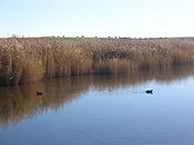
|
Ciudad Real | Castile-La Mancha | 1973 | 3,030 ha (7,487 acres) |
[20] | |
| Teide | 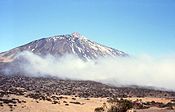
|
Santa Cruz de Tenerife (Tenerife island) | Canary Islands | 1954 | 18,990 ha (46,925 acres) |
Atop the highest mountain of Spain, this national park, also a UNESCO world heritage site, features volcanic mountains, various plant species including the fragile species such as the Canary Island cedar and the Canaray island pine, and a few birds and animals. | [21] |
| Timanfaya | 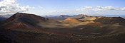
|
Las Palmas (Lanzarote island) | Canary Islands | 1974 | 5,107 ha (12,620 acres) |
[22] |
See also[]
- List of national parks of Spain and their relationship to sites of community importance
- Ministry of Environment (Spain)
- Natural park (Spain)
- Àrea natural d'especial interès — protected areas in the Balearic Islands
References[]
- ^ https://www.miteco.gob.es/es/red-parques-nacionales/la-red/gestion/visitasppnn_tcm30-67283.pdf
- ^ Millet, Daniel (10 February 2014). "El Teide se sitúa entre los diez parques nacionales más visitados del mundo". La Opinión de Tenerife (in Spanish). Retrieved 5 November 2015.
- ^ "Aigüestortes i Estany de Sant Maurici: El medio natural". magrama.gob.es (in Spanish). Ministry of Agriculture, Food and Environment. 2015. Retrieved 4 November 2015.
- ^ "Aigüestortes i Estany de Sant Maurici: Ficha técnica". magrama.gob.es (in Spanish). Ministry of Agriculture, Food and Environment. 2015. Retrieved 4 November 2015.
- ^ "Cabañeros: Valores naturales". magrama.gob.es (in Spanish). Ministry of Agriculture, Food and Environment. 2015. Retrieved 4 November 2015.
- ^ "Cabañeros: Ficha técnica". magrama.gob.es (in Spanish). Ministry of Agriculture, Food and Environment. 2015. Retrieved 4 November 2015.
- ^ "Archipiélago de Cabrera: La isla". magrama.gob.es (in Spanish). Ministry of Agriculture, Food and Environment. 2015. Retrieved 4 November 2015.
- ^ "Archipiélago de Cabrera: Ficha técnica". magrama.gob.es (in Spanish). Ministry of Agriculture, Food and Environment. 2015. Retrieved 4 November 2015.
- ^ "Caldera de Taburiente: Ficha técnica". magrama.gob.es (in Spanish). Ministry of Agriculture, Food and Environment. 2015. Retrieved 4 November 2015.
- ^ "Doñana: Ficha técnica". magrama.gob.es (in Spanish). Ministry of Agriculture, Food and Environment. 2015. Retrieved 4 November 2015.
- ^ "Garajonay: Ficha técnica". magrama.gob.es (in Spanish). Ministry of Agriculture, Food and Environment. 2015. Retrieved 4 November 2015.
- ^ "Sierra de Guadarrama: Ficha técnica". magrama.gob.es (in Spanish). Ministry of Agriculture, Food and Environment. 2015. Retrieved 4 November 2015.
- ^ "Islas Atlánticas de Galicia: Ficha técnica". magrama.gob.es (in Spanish). Ministry of Agriculture, Food and Environment. 2015. Retrieved 4 November 2015.
- ^ "Monfragüe: Ficha técnica". magrama.gob.es (in Spanish). Ministry of Agriculture, Food and Environment. 2015. Retrieved 4 November 2015.
- ^ "Ordesa y Monte Perdido: Ficha técnica". magrama.gob.es (in Spanish). Ministry of Agriculture, Food and Environment. 2015. Retrieved 4 November 2015.
- ^ "Picos de Europa: El medio natural". magrama.gob.es (in Spanish). Ministry of Agriculture, Food and Environment. 2015. Retrieved 4 November 2015.
- ^ "Picos de Europa: Ficha técnica". magrama.gob.es (in Spanish). Ministry of Agriculture, Food and Environment. 2015. Retrieved 4 November 2015.
- ^ "Sierra Nevada: Medio natural". magrama.gob.es (in Spanish). Ministry of Agriculture, Food and Environment. 2015. Retrieved 4 November 2015.
- ^ "Sierra Nevada: Ficha técnica". magrama.gob.es (in Spanish). Ministry of Agriculture, Food and Environment. 2015. Retrieved 4 November 2015.
- ^ "Tablas de Daimiel: Ficha técnica". magrama.gob.es (in Spanish). Ministry of Agriculture, Food and Environment. 2015. Retrieved 4 November 2015.
- ^ "Teide: Ficha técnica". magrama.gob.es (in Spanish). Ministry of Agriculture, Food and Environment. 2015. Retrieved 4 November 2015.
- ^ "Timanfaya: Ficha técnica". magrama.gob.es (in Spanish). Ministry of Agriculture, Food and Environment. 2015. Retrieved 4 November 2015.
External links[]
| Wikimedia Commons has media related to National parks of Spain. |
- National parks of Spain
- Lists of national parks
- Spain geography-related lists
- Parks in Spain
- Lists of tourist attractions in Spain