List of shipwrecks in the Indian Ocean
This is a list of shipwrecks in the Indian Ocean.

Map of the Indian Ocean
Arabian Sea[]
| Ship | Sunk date | Notes | Coordinates |
|---|---|---|---|
| 9 June 1897 | A P&O steamship that was wrecked on Socotra island, off the coast of Yemen. | ||
| SS Berwyn | 6 September 1920 | A cargo ship that was wrecked near the Khuriya Muriya Islands. | |
| HMS Cadiz | 4 December 1971 | A Battle-class destroyer that was sunk by INS Nirghat south of Karachi. | |
| MOL Comfort | 2013 | A container ship that broke apart in bad weather on 17 June 2013. The stern section took on water and sank on 26 June; the bow was taken under tow, but caught fire and sank on 11 July. | 14°26′N 66°26′E / 14.433°N 66.433°E, 19°56′N 65°25′E / 19.933°N 65.417°E |
| MS Georges Philippar | 19 May 1932 | An ocean liner that caught fire and sank near Mukalla, Yemen. | 14°20′N 50°25′E / 14.333°N 50.417°E |
| SS John Barry | 28 August 1944 | A Liberty ship that was torpedoed by U-859 off the coast of Oman. | 15°06′N 55°11′E / 15.10°N 55.18°E |
| INS Khukri | 9 December 1971 | A Blackwood-class frigate that was torpedoed by PNS Hangor off Diu, India. | 20°16′38″N 70°59′37″E / 20.27722°N 70.99361°E |
| SS Santa Paula | 3 June 1943 | A freighter that was torpedoed by I-27 150 miles (240 km) south of Masirah Island, Oman. | 17°05′04″N 58°05′00″E / 17.08444°N 58.08333°E |

Bay of Bengal[]
| Ship | Sunk date | Notes | Coordinates |
|---|---|---|---|
| SS Automedon | 11 November 1940 | A passenger and cargo steamer that was sunk by the German auxiliary cruiser Atlantis northwest of Sumatra. | |
| HMS Hermes | 9 April 1942 | The world's first purpose-built aircraft carrier, which sunk after receiving 40 direct hits 70 Mitsubishi A6M Zero fighter/bombers off the coast of Sri Lanka. | 7°35′N 82°5′E / 7.583°N 82.083°E |
| SS Indus | 10 September 1914 | A steamship that was captured and scuttled by SMS Emden. | 11°00′N 83°45′E / 11.000°N 83.750°E |
| SS Selma City | 7 April 1942 | Attacked by Japanese bombers in the Bay of Bengal, about 25 miles (40 km) offshore from Vizagapatam (now Vishakhapatnam), India. | 17°11′N 83°20′E / 17.183°N 83.333°E |
| HMAS Vampire | 9 April 1942 | A V-class destroyer that was sunk by Japanese aircraft off the coast of Sri Lanka. | 7°35′N 82°5′E / 7.583°N 82.083°E |
Central Indian Ocean[]
| Ship | Sunk date | Notes | Coordinates |
|---|---|---|---|
| Arnhem | 12 February 1662 | An East Indiaman that ran aground on the Saint Brandon Rocks. | |
| SS Chivalry | 22 February 1944 | A cargo ship that was sunk by a Japanese submarine. | 0°50′S 68°0′E / 0.833°S 68.000°E |
| SS City of Johannesburg | 23 October 1942 | A merchant steamer that was torpedoed by U-504 off East London, South Africa. | 33°20′S 29°30′E / 33.333°S 29.500°E |
| SS Clan Macarthur | 12 August 1943 | A Cameron-class cargo steamship that was torpedoed by U-181 off Madagascar. | 23°00′S 53°07′E / 23°S 53.11°E |
| SS Commissaire Ramel | 9 September 1940 | A passenger ship that was sunk by the German auxiliary cruiser Atlantis. | 28°25′S 74°23′E / 28.417°S 74.383°E |
| HMS Cornwall | 5 April 1942 | A County-class heavy cruiser that was sunk by Japanese dive bombers in the Easter Sunday Raid. | 1°54′N 77°54′E / 1.900°N 77.900°E |
| HMS Dorsetshire | 5 April 1942 | A County-class heavy cruiser that was sunk by Japanese dive bombers in the Easter Sunday Raid. | 1°54′N 77°45′E / 1.900°N 77.750°E |
| SS Empire Chaucer | 17 October 1942 | A cargo ship that was torpedoed by U-504 about 450 nautical miles (830 km; 520 mi) south of Cape Town, South Africa. | 38°12′S 20°04′E / 38.200°S 20.067°E |
| MV Empire Day | 7 August 1944 | A cargo ship that was torpedoed by U-198 about 200 nautical miles (370 km; 230 mi) east of Dar es Salaam, Tanzania. | 7°06′S 42°00′E / 7.100°S 42.000°E |
| SS Fort Lee | 2 November 1944 | A T2 tanker that was torpedoed by U-181. | 27°35′S 83°11′E / 27.583°S 83.183°E |
| SS Frontier | 27 September 1957 | A cargo ship that ran aground east of East London, Eastern Cape, Africa. | |
| I-27 | 12 February 1944 | A Japanese submarine that was sunk by HMS Paladin and HMS Petard. | 01°25′N 72°22′E / 1.417°N 72.367°E |
| SS James B. Stephens | 8 March 1943 | A Liberty ship that was torpedoed by U-160 about 150 miles (240 km) northeast of Durban, South Africa. | 28°53′S 33°18′E / 28.883°S 33.300°E |
| SS Khedive Ismail | 12 February 1944 | A steamship that was torpedoed by I-27, with 1,297 deaths. | 01°25′N 72°22′E / 1.417°N 72.367°E |
| SS Koning der Nederlanden | 5 October 1881 | An ocean liner that sprang a leak and sank east of the Seychelles. | 5°14′S 64°7′E / 5.233°S 64.117°E |
| Magicienne | 24 August 1810 | A Magicienne-class frigate that ran aground off Mauritius in the Battle of Grand Port. | |
| SS Marietta E | 4 March 1943 | A cargo ship that was torpedoed by U-160. | 31°29′S 31°07′E / 31.49°S 31.11°E |
| USS Pecos | 1 March 1942 | A tanker that was sunk by Japanese aircraft. | 14°27′S 106°11′E / 14.450°S 106.183°E |
| Pinguin | 8 May 1941 | An auxiliary cruiser that was sunk by HMS Cornwall. | 3°30′0″N 57°48′0″E / 3.50000°N 57.80000°E |
| Ramb I | 27 February 1941 | An auxiliary cruiser that was sunk by HMNZS Leander in the action of 27 February 1941. | 1°0′N 68°30′E / 1.000°N 68.500°E |
| HMS Sirius | 23 August 1810 | A frigate that ran aground off Mauritius in the Battle of Grand Port. | |
| Texanita | 21 August 1972 | An oil tanker that collided with Oswego-Guardian off Stilbaai, South Africa. | 34°48′S 21°24′E / 34.80°S 21.40°E |
| SS Tjisalak | 26 March 1944 | A cargo ship that was torpedoed by I-8. | 2°30′S 78°40′E / 2.500°S 78.667°E |
| RIMS Warren Hastings | 14 January 1897 | A troop ship that hit a rock and was wrecked off the coast of Réunion. |
Christmas Island[]
| Ship | Sunk date | Notes | Coordinates |
|---|---|---|---|
| MV Eidsvold | 20 January 1942 | A motor vessel that was torpedoed by I-159 at Flying Fish Cove. | |
| SIEV-221 | 15 December 2010 | A boat that was carrying asylum seekers from Iraq and Iran when it hit the rocks at Flying Fish Cove. | 10°25′1″S 105°40′24″E / 10.41694°S 105.67333°E |
| MV Tycoon | 8 January 2012 | A cargo ship that was wrecked at Flying Fish Cove. |
Cocos (Keeling) Islands[]
| Ship | Sunk date | Notes | Coordinates |
|---|---|---|---|
| SS Buresk | 9 November 1914 | A collier that was scuttled while under attack from HMAS Sydney in the Battle of Cocos. | |
| SMS Emden | 9 November 1914 | A light cruiser that was run aground while under attack from HMAS Sydney in the Battle of Cocos. |
Great Australian Bight[]
| Ship | Sunk date | Notes | Coordinates |
|---|---|---|---|
| Mahomed Shah | April 1853 | A barque that caught fire on 18 April and sank several days later. All on board were rescued. | 40°10′00″S 119°10′00″E / 40.16667°S 119.16667°E |
| SS Selje | 29 March 1929 | A cargo ship that collided with the steamship Kaituna 25 miles (40 km) southwest of Cape Otway. |
Mozambique Channel[]
| Ship | Sunk date | Notes | Coordinates |
|---|---|---|---|
| Admiral Gambier | 20 June 1817 | An East Indiaman that was wrecked on a coral reef. | |
| MV Empire City | 6 August 1944 | A cargo ship that was torpedoed by U-198 off Mocímboa da Praia, Mozambique. | 11°33′S 41°25′E / 11.550°S 41.417°E |
| SS Express | 30 June 1942 | A Type C3-E cargo ship that was torpedoed by I-10. | 23°30′S 37°30′E / 23.500°S 37.500°E |
Persian Gulf[]
| Ship | Sunk date | Notes | Coordinates |
|---|---|---|---|
| Iran Ajr | 26 September 1987 | A landing craft that served as a minelayer during the Iran–Iraq War, and was captured and scuttled by American forces. | |
| U-533 | 16 October 1943 | A Type IXC/40 U-boat that was sunk by British aircraft off the coast of Fujairah. | 25°28′N 56°50′E / 25.467°N 56.833°E |
Red Sea[]
| Ship | Sunk date | Notes | Coordinates |
|---|---|---|---|
| 15 September 1957 | An Egyptian supply ship, sunk off the coast of Big Brother Island.[citation needed] | 26°19′N 34°50′E / 26.317°N 34.833°E | |
| Al-Baraqua II | 6 April 2006 | Capsized passenger ferry. | |
| MS al-Salam Boccaccio 98 | 3 February 2006 | Capsized passenger ferry. | 27°01′59″N 34°52′59″E / 27.033°N 34.883°E |
| SS Carnatic | 15 September 1869 | Ran aground on a coral reef on 12 September, broke in half and sank three days later. 31 people drowned.[1] | 27°34′N 33°55′E / 27.567°N 33.917°E |
| 31 August 1981 | Greek freighter that ran aground on a reef.[2] | 27°34′53″N 33°55′55″E / 27.58139°N 33.93194°E | |
| SS Dunraven | 25 April 1876 | Hit a reef in the Gulf of Suez, close to the Sinai peninsula.[citation needed] | 27°25′17″N 34°04′23″E / 27.4215°N 34.0730°E |
| 19 April 1983 | Sank with its cargo of timber at Sha'ab Abu Nuhas, north of Hurghada.[citation needed] | ||
| 12 December 1978 | Sank on at Sha'ab Abu Nuhas, north of Hurghada, when she ran into the reef of Abu Nuhas.[3] | 27°34′48″N 33°56′00″E / 27.58000°N 33.93333°E | |
| 20 July 1901 | Sank at Big Brother Island.[citation needed] | 26°19′N 34°50′E / 26.317°N 34.833°E | |
| 1969 | Former Russian navy ship, bombed by the Israelis and sank near Hurghada.[4] | 27°13′55″N 33°51′34″E / 27.23194°N 33.85944°E | |
| October 1941 | Bombed 2 days after the supply ship Thistlegorm – anchored some 20 miles (32 km) away next to the Sinai peninsula – was sunk. She rests north of Hurghada, north of the reefs of Abu Nuhas, in some 50 meters of water.[5] | 27°39′03″N 33°46′17″E / 27.65083°N 33.77139°E | |
| Salem Express | 17 December 1991 | Ran into a shallow reef and sank 57 miles (about 91 km) south of Hurghada, after the captain took a shortcut on his trip from Jeddah (Saudi Arabia) to Safaga in Egypt. | 26°38′22.02″N 34°3′39.9″E / 26.6394500°N 34.061083°E |
| SS Thistlegorm | 6 October 1941 | Sunk by German bombers near Sharm el-Sheikh.[6] | 27°48′51″N 33°55′12″E / 27.81417°N 33.92000°E |
| SS Umbria | 9 June 1940 | Scuttled by Italian crew near Port Sudan | 19°38′19″N 37°19′38″E / 19.63861°N 37.32722°E |
| Zingara | 22 August 1984 | Commonly referred to as the Kormoran, sailed from Aqaba with a cargo of Phosphate Rock and hit the Laguna Reef in the Strait of Tiran. |
Strait of Malacca[]
| Ship | Sunk date | Notes | Coordinates |
|---|---|---|---|
| MS Empress of Australia | 23 August 1992 | A cruise ship that sank in a collision with the Taiwanese fishing vessel Terfu 51. | |
| SS Galileo Galilei | 21 May 1999 | A cruise ship that sank off the coast of Perak following a fire. | 4°37′1″N 99°54′6″E / 4.61694°N 99.90167°E |
| USS Grenadier | 22 April 1943 | A Tambor-class submarine that was bombed by Japanese aircraft and scuttled the next day. | 6°30′N 97°40′E / 6.500°N 97.667°E |
| Haguro | 16 May 1945 | A Myōkō-class cruiser that was sunk by British forces in the Battle of the Malacca Strait. | |
| I-166 | 17 July 1944 | A KD5 Type submarine that was sunk by HMS Telemachus (P321) off One Fathom Bank. | 2°48′N 101°03′E / 2.800°N 101.050°E |
| Kuma | 11 January 1944 | A Kuma-class cruiser that was sunk by HMS Tally-Ho (P317). | 5°26′N 99°52′E / 5.433°N 99.867°E |
| Myōkō | 8 June 1946 | A Myōkō-class cruiser that was scuttled near Port Klang. | 3°5′N 100°40′E / 3.083°N 100.667°E |
| Reginaldo Giuliani | 14 February 1944 | A Liuzzi-class submarine that was seized by Germany and renamed UIT-23, and was torpedoed by HMS Tally-Ho northwest of Pangkor Island. | 04°27′N 100°11′E / 4.450°N 100.183°E |
| Sovereign of the Seas | 6 August 1859 | A clipper that was wrecked on the Pyramid Shoal. | |
| Takao | 19 October 1946 | A Takao-class heavy cruiser that was surrendered to the British and sunk as a target. | 03°05′05″N 100°41′00″E / 3.08472°N 100.68333°E |
| U-181 | 12 February 1946 | A Type IXD2 U-boat that was scuttled near Port Klang. | 3°05′50″N 100°42′50″E / 3.09722°N 100.71389°E |
| U-859 | 23 September 1944 | A Type IXD2 U-boat that was sunk by HMS Trenchant. | 5°46′01″N 100°04′01″E / 5.767°N 100.067°E |
| U-862 | 13 February 1946 | A Type IXD2 U-boat that was scuttled near Port Klang. | 3°05′N 100°38′E / 3.083°N 100.633°E |
| HMS Vestal | 26 July 1945 | An Algerine-class minesweeper that suffered a kamikaze attack and was scuttled. | 07°05′N 97°50′E / 7.083°N 97.833°E |
References[]
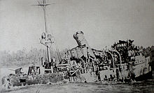
The wreck of SMS Emden
| Wikimedia Commons has media related to Shipwrecks in the Indian Ocean. |
- ^ "DiveSiteDirectory for Carnatic". Divesitedirectory.co.uk. Retrieved 27 April 2010.
- ^ "DiveSiteDirectory for Chrisoula K". Divesitedirectory.co.uk. 31 August 1981. Retrieved 27 April 2010.
- ^ "DiveSiteDirectory for Kimon M". Divesitedirectory.co.uk. 12 December 1978. Retrieved 27 April 2010.
- ^ "DiveSiteDirectory for El Mina". Divesitedirectory.co.uk. Retrieved 27 April 2010.
- ^ "DiveSiteDirectory for Rosalie Moller". Divesitedirectory.co.uk. 19 November 2009. Retrieved 27 April 2010.
- ^ "DiveSiteDirectory for Thistlegorm". Divesitedirectory.co.uk. Retrieved 27 April 2010.
Categories:
- Lists of shipwrecks by location
- Indian Ocean
- Shipwrecks in the Indian Ocean