List of waterfalls by flow rate
This list of waterfalls by flow rate includes all waterfalls which are known to have an average flow rate or discharge of at least 150 cubic metres per second (5,300 cu ft/s). The waterfalls in this list are those for which there is verifiable information for, and should not be assumed to be a complete list of waterfalls which would otherwise qualify as globally significant based on this metric.
Largest extant waterfalls[]


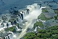
The first five waterfalls by power (Guaíra, Khone Phapheng, Iguazú, Niagara, and Victoria) are called the Great Five Waterfalls.[55][56]
Largest historic waterfalls[]
This list comprises the waterfalls which have ceased to exist due to the impoundment of their river(s) by a dam, or due to the diversion of the watercourse.
| Waterfall | Image | Flow rate (m3/s) | Drop (m) | Width (m) | River | Countries | Coordinates | Notes |
|---|---|---|---|---|---|---|---|---|
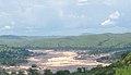
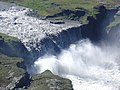
| Guaíra Falls | 
|
13,309 | 40 | 4,828 | Paraná | 24°04′03″S 54°17′00″W / 24.067547°S 54.283276°W | Submerged beneath the Itaipu Reservoir following the completion of the Itaipu Dam in 1982.[57] | |
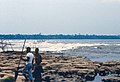
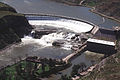
| Celilo Falls | 
|
5,366 | 6.1 | 1,768 | Columbia | 45°39′05″N 120°58′10″W / 45.65147°N 120.96941°W | Submerged beneath the Columbia River following the completion of The Dalles Dam in 1957. The rock formation responsible for the falls remains intact.[58][59] | |
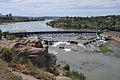
| Kettle Falls | 
|
4,682 | ? | ? | Columbia | 48°37′52″N 118°07′08″W / 48.63099°N 118.11897°W | Submerged beneath Lake Roosevelt following the completion of the Grand Coulee Dam in 1940. The formation responsible for the falls remains intact.[60] | |
| 2,747 | 13 | 2,012 | Paraná | 20°36′S 51°33′W / 20.6°S 51.55°W | Submerged beneath the Paraná River following completion of the Engineer Souza Dias Dam in 1982. The formation responsible for the falls remains intact.[61] | |||
| 1,501 | 24 | 2,012 | Rio Grande | 20°18′35″S 49°12′06″W / 20.30972°S 49.20167°W | The Marimbondo Dam was built atop the upper portion of the falls in 1971. The section further upstream was submerged beneath the Rio Grande, while the section below the dam was dewatered and are visible.[62] | |||
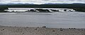
| San Rafael Falls | 
|
400 | 94 | 23 | Coca | 0°06′15″S 77°34′51″W / 0.104303°S 77.580967°W | On 2 February 2020, a large sinkhole formed just above the falls, diverting its flow beneath a large band of rock (the former brink of the falls) which survived the collapse and became a natural bridge. Although the river initially still fell over 100 m (330 ft) into the sinkhole, very rapid headward erosion has since left no significant waterfall at this location.[63][64][65] |
Prehistoric waterfalls[]
| Waterfall | Maximum daily flow rate (m3/s) | Tallest single drop (m) | Width (m) | River | Countries |
|---|---|---|---|---|---|
| Gibraltar (Zanclean deluge hypothesis) | 108[66] | Strait of Gibraltar | |||
| Dry Falls | 1,906,000[67] | 120 | 4,828 | Columbia | |
| Bosphorus (Black Sea deluge hypothesis) | 482,407[68] | 80 | Bosphorus Strait |
See also[]
- Waterfall
- List of rivers by discharge
- List of waterfalls
- List of waterfalls by height
- List of waterfalls by type
- Orders of magnitude (power)
References[]
- ^ "Inga Falls, Congo, Democratic Republic of the – World Waterfall Database". www.worldwaterfalldatabase.com. Retrieved 2020-01-16.
- ^ "Livingstone, Chutes de, Congo, Democratic Republic of the – World Waterfall Database". www.worldwaterfalldatabase.com. Retrieved 2020-01-16.
- ^ Ndeo, Oscar; Hauffe, Torsten; Delicado, Diana; Busanga, Alidor; Albrecht, Christian (2017-05-02). "Mollusk communities of the central Congo River shaped by combined effects of barriers, environmental gradients, and species dispersal". Journal of Limnology. 76. doi:10.4081/jlimnol.2017.1585.
- ^ "Wagenia, Chutes, Congo, Democratic Republic of the – World Waterfall Database". www.worldwaterfalldatabase.com. Retrieved 2020-01-16.
- ^ "Khone, Chutes de, Laos – World Waterfall Database". www.worldwaterfalldatabase.com. Retrieved 2020-01-16.
- ^ "Pará, Salto, Venezuela – World Waterfall Database". www.worldwaterfalldatabase.com. Retrieved 2020-01-16.
- ^ "Paulo Afonso, Cachoeira de, Brazil – World Waterfall Database". www.worldwaterfalldatabase.com. Retrieved 2020-01-16.
- ^ "Niagara Falls, Ontario, Canada – World Waterfall Database". www.worldwaterfalldatabase.com. Retrieved 2020-01-16.
- ^ "Vermilion Falls, Alberta, Canada – World Waterfall Database". www.worldwaterfalldatabase.com. Retrieved 2020-01-16.
- ^ "Iguazú, Cataratas del, Argentina – World Waterfall Database". www.worldwaterfalldatabase.com. Retrieved 2020-01-16.
- ^ "Calcaire, Chute du, Quebec, Canada - World Waterfall Database". www.worldwaterfalldatabase.com. Retrieved 2020-12-28.
- ^ "Pyrite, Chute de la, Quebec, Canada - World Waterfall Database". www.worldwaterfalldatabase.com. Retrieved 2020-12-28.
- ^ "Victoria Falls, Zimbabwe – World Waterfall Database". www.worldwaterfalldatabase.com. Retrieved 2020-01-16.
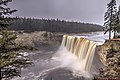
- ^ "Virginia Falls, Northwest Territories, Canada – World Waterfall Database". www.worldwaterfalldatabase.com. Retrieved 2020-01-16.
- ^ "Schistes, Chute aux, Quebec, Canada - World Waterfall Database". www.worldwaterfalldatabase.com. Retrieved 2020-12-28.
- ^ "Sivasamudram Falls, India – World Waterfall Database". www.worldwaterfalldatabase.com. Retrieved 2020-01-16.
- ^ "Willamette Falls, Oregon, United States – World Waterfall Database". www.worldwaterfalldatabase.com. Retrieved 2020-01-16.
- ^ "Kongou Falls, Gabon – World Waterfall Database". www.worldwaterfalldatabase.com. Retrieved 2020-01-16.
- ^ "Kootenai Falls, Montana, United States – World Waterfall Database". www.worldwaterfalldatabase.com. Retrieved 2020-01-16.
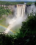
- ^ "Kaieteur Falls, Guyana – World Waterfall Database". www.worldwaterfalldatabase.com. Retrieved 2020-01-16.
- ^ "Rheinfall, Switzerland – World Waterfall Database". www.worldwaterfalldatabase.com. Retrieved 2020-01-16.
- ^ "Kalandula Falls, Angola – World Waterfall Database". www.worldwaterfalldatabase.com. Retrieved 2020-01-16.
- ^ "Graphique des données à une station hydrométrique". www.cehq.gouv.qc.ca. Retrieved 2020-11-04.
- ^ "Great Falls, Maryland, United States – World Waterfall Database". www.worldwaterfalldatabase.com. Retrieved 2020-01-17.
- ^ "Granite, Chute au, Quebec, Canada - World Waterfall Database". www.worldwaterfalldatabase.com. Retrieved 2020-12-28.
- ^ "Hidden Falls, China – World Waterfall Database". www.worldwaterfalldatabase.com. Retrieved 2020-01-17.
- ^ "Urriðafoss, Iceland – World Waterfall Database". www.worldwaterfalldatabase.com. Retrieved 2020-01-17.
- ^ "Little Eaton Canyon Falls, Quebec, Canada - World Waterfall Database". www.worldwaterfalldatabase.com. Retrieved 2020-12-28.
- ^ "Lower Eaton Canyon Falls, Quebec, Canada - World Waterfall Database". www.worldwaterfalldatabase.com. Retrieved 2020-12-28.
- ^ "Nastapoca, Chutes, Quebec, Canada - World Waterfall Database". www.worldwaterfalldatabase.com. Retrieved 2020-12-28.
- ^ "Tuktu, Chute, Quebec, Canada - World Waterfall Database". www.worldwaterfalldatabase.com. Retrieved 2020-12-28.
- ^ "Twin Falls, Quebec, Canada - World Waterfall Database". www.worldwaterfalldatabase.com. Retrieved 2020-12-28.
- ^ "Upper Eaton Canyon Falls, Quebec, Canada - World Waterfall Database". www.worldwaterfalldatabase.com. Retrieved 2020-12-28.
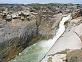
- ^ "Augrabies Falls, South Africa – World Waterfall Database". www.worldwaterfalldatabase.com. Retrieved 2020-01-17.
- ^ "Murchison Falls, Uganda – World Waterfall Database". www.worldwaterfalldatabase.com. Retrieved 2020-01-17.
- ^ "Alexandra Falls, Northwest Territories, Canada – World Waterfall Database". www.worldwaterfalldatabase.com. Retrieved 2020-01-17.
- ^ "Louise Falls, Northwest Territories, Canada – World Waterfall Database". www.worldwaterfalldatabase.com. Retrieved 2020-01-17.
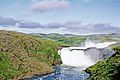
- ^ "Dettifoss, Iceland – World Waterfall Database". www.worldwaterfalldatabase.com. Retrieved 2020-01-17.
- ^ "Hafragilsfoss, Iceland – World Waterfall Database". www.worldwaterfalldatabase.com. Retrieved 2020-01-17.
- ^ "Réttarfoss, Iceland – World Waterfall Database". www.worldwaterfalldatabase.com. Retrieved 2020-01-17.
- ^ "Selfoss, Iceland – World Waterfall Database". www.worldwaterfalldatabase.com. Retrieved 2020-01-17.
- ^ "Sandstone Falls, West Virginia, United States - World Waterfall Database". www.worldwaterfalldatabase.com. Retrieved 2020-04-15.
- ^ "Huka Falls, Waikato, New Zealand - World Waterfall Database". www.worldwaterfalldatabase.com. Retrieved 2020-11-03.
- ^ "Huka Falls New Zealand". www.hukafalls.com. Retrieved 2020-11-03.
- ^ "Big Falls, Montana, United States - World Waterfall Database". www.worldwaterfalldatabase.com. Retrieved 2020-11-03.
- ^ a b c d Mineral and Water Resources of Montana. Stermitz, Frank; Hanly, T. F.; and Lane, C. W. Special Publication No. 28. Helena, Mont.: Montana Bureau of Mines and Geology, May 1963.
- ^ "Black Eagle Falls, Montana, United States - World Waterfall Database". www.worldwaterfalldatabase.com. Retrieved 2020-11-03.
- ^ "Crooked Falls, Montana, United States - World Waterfall Database". www.worldwaterfalldatabase.com. Retrieved 2020-11-03.
- ^ "Rainbow Falls, Montana, United States - World Waterfall Database". www.worldwaterfalldatabase.com. Retrieved 2020-11-03.
- ^ "Storforsen, Sweden - World Waterfall Database". www.worldwaterfalldatabase.com. Retrieved 2020-04-15.
- ^ "Rearguard Falls, British Columbia, Canada - World Waterfall Database". www.worldwaterfalldatabase.com. Retrieved 2020-04-15.
- ^ "Brookfield Power". National Hydropower Association. Retrieved 2020-11-02.
- ^ "Cohoes Falls, New York, United States - World Waterfall Database". www.worldwaterfalldatabase.com. Retrieved 2020-04-15.
- ^ "Jog Falls, India - World Waterfall Database". www.worldwaterfalldatabase.com. Retrieved 2020-04-15.
- ^ Г. Т. Арсеев. Водопады. — М.: Мысль, 1987. — С. 14. — 127 с.
- ^ В. И. Задорожный, К. В. Зворыкин. Методология и региональные физико-географические исследования. — М.: Географическое общество СССР, 1975. — С. 60. — 78 с.
- ^ "Guaíra, Salto del, Brazil – World Waterfall Database". www.worldwaterfalldatabase.com. Retrieved 2020-01-16.
- ^ "Celilo Falls, Oregon, United States – World Waterfall Database". www.worldwaterfalldatabase.com. Retrieved 2020-01-16.
- ^ Gibson, James R. (1997). The Lifeline of the Oregon Country: The Fraser-Columbia Brigade System, 1811-47. University of British Columbia (UBC) Press. pp. 125–128. ISBN 0-7748-0643-5.
- ^ "Kettle Falls, Washington, United States – World Waterfall Database". www.worldwaterfalldatabase.com. Retrieved 2020-01-16.
- ^ "Urubupunga, Salto do, Brazil – World Waterfall Database". www.worldwaterfalldatabase.com. Retrieved 2020-01-16.
- ^ "Patos e Maribondo, Saltos dos, Brazil – World Waterfall Database". www.worldwaterfalldatabase.com. Retrieved 2020-01-16.
- ^ "Why did Ecuador's tallest waterfall suddenly disappear?". Mongabay Environmental News. 2020-03-18. Retrieved 2020-04-03.
- ^ "The Disappearance of Ecuador's Tallest Waterfall". earthobservatory.nasa.gov. 2020-03-27. Retrieved 2020-04-03.
- ^ "San Rafael, Cascada de, Ecuador – World Waterfall Database". www.worldwaterfalldatabase.com. Retrieved 2020-01-17.
- ^ Garcia-Castellanos, D., Estrada, F., Jiménez-Munt, I., Gorini, C., Fernàndez, M., Vergés, J., De Vicente, R. (10 December 2009) Catastrophic flood of the Mediterranean after the Messinian salinity crisis, Nature 462, pp. 778–781, doi:10.1038/nature08555
- ^ The Channeled Scablands of Eastern Washington, United States Geological Survey, retrieved 2012-03-15
- ^ Ryan, W.B.F.; Pitman III, W.C., et al. 1997. An abrupt drowning of the Black Sea shelf. Marine Geology, 138: 119–126.
External links[]
Categories:
- Lists of waterfalls