Great Falls (Potomac River)
| Great Falls | |
|---|---|
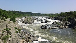 View of the Great Falls from Virginia. | |
| Location | Montgomery County, Maryland and Fairfax County, Virginia |
| Coordinates | 38°59′51″N 77°15′09″W / 38.99750°N 77.25250°WCoordinates: 38°59′51″N 77°15′09″W / 38.99750°N 77.25250°W |
| Type | Steep Tiered Cascades |
| Elevation | 129 ft (39 m) |
| Total height | 47 ft (14 m) [1] |
| Average width | 350 ft (110 m) [1] |
| Run | 550 ft (170 m) [1] |
| Watercourse | Potomac River |
| Average flow rate | 16,750 cu ft/s (474 m3/s) (est.) [1] |


Great Falls is a series of rapids and waterfalls on the Potomac River, 14 miles (23 km) upstream from Washington, D.C., on the border of Montgomery County, Maryland and Fairfax County, Virginia. Great Falls Park, managed as part of George Washington Memorial Parkway, is on the southern banks in Virginia, and Chesapeake and Ohio Canal National Historical Park parkland is along the northern banks of the river in Maryland. Both are operated by the National Park Service. The Potomac and the falls themselves are legally entirely within Maryland, with the state and county boundaries following the south bank of the river.
Scenic views are offered on both the Maryland side and the Virginia side. The Billy Goat Trail on Bear Island, accessible from Maryland, offers scenic views of the Great Falls, as do vantage points on Olmsted Island (also accessible from Maryland). There are overlook points on the Virginia side.
The Great Falls area is popular for outdoor activities such as kayaking, whitewater rafting, rock climbing, and hiking.
Great Falls and Little Falls (about 5 miles downstream) are named in contradistinction to one another.
History[]
This section needs expansion. You can help by . (August 2010) |
The rocks of the falls date to the late Precambrian and are about 750 million years old.[2] The rocks are a resistant metamorphized schist, gneisses, , and .[2] The Falls formed the last time sea level dropped, during the Last Glacial Period about 35,000 years ago, causing the Potomac to downcut its valley.[2] The river cascades over a series of 20-foot (6.1 m) falls, dropping a total of 76 feet (23 m) in elevation over a distance of less than 1 mile (1.6 km).[3] As sea level rises again, the power of the falls will be reduced due to a shorter vertical drop and likewise downcutting will slow down. Should the ocean level ever exceed the height of the falls again, downcutting would reverse entirely with silt filling in the now-underwater falls.
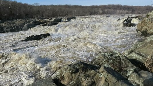
The Potomac narrows significantly as it passes over the falls and through Mather Gorge. Heavy rain or snow in the watershed upstream causes white-water floods which entirely submerge the rocks and even threaten the adjacent park visitor center (built on stilts for this reason). A pillar at the Virginia overlook, well above the river, marks the level of the 1936 Potomac Flood.
Gallery[]

Southward view of the Potomac River from a footbridge on Olmsted Island. July 2021.

Great Falls panorama from Virginia

Great Falls panorama from Maryland
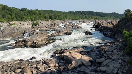
View of Great Falls from the Olmsted Island overlook
Great Falls of the Potomac River, between Virginia and Maryland in the United States. January 1, 2014


Canals[]

Various attempts to build canals around Great Falls were undertaken. The remains of the Patowmack Canal on the Virginia side, were an early attempt to skirt the falls, using 5 locks. That canal was started by George Washington. Later the Chesapeake and Ohio Canal was built on the Maryland side of the falls and ultimately connected the Potomac tidewater with Cumberland, Maryland. The Chesapeake and Ohio also used the Great Falls as a feeder (now abandoned) to supply water for its own use.
See also[]
| Wikimedia Commons has media related to Great Falls of the Potomac River. |
Notes[]
- ^ Jump up to: a b c d "Great Falls, Maryland, United States - World Waterfall Database". www.worldwaterfalldatabase.com. Retrieved 2020-01-17.
- ^ Jump up to: a b c "The Great Falls of the Potomac, Montgomery County". Maryland Geological Survey. Retrieved June 19, 2020.
- ^ "Great Falls of the Potomac : Image of the Day". NASA. July 29, 2004. Archived from the original on October 12, 2004. Retrieved August 17, 2010.
References[]
- "Great Falls of the Potomac". NASA Earth Observatory. Archived from the original on 2004-10-12. Retrieved 2006-05-24.
External links[]
- Great Falls Visitor Center official site
- Great Falls Park official site
- Satellite imagery of Great Falls on Google Maps
- Great Falls rages and roars in Potomac flood (photos and video) - Washington Post (17 May 2014)
- Great Falls Timeline by NPS
- Video showing the Falls from 2016
| show Authority control |
|---|
- Landforms of Fairfax County, Virginia
- Tourist attractions in Montgomery County, Maryland
- Potomac River
- Waterfalls of Virginia
- Waterfalls of Maryland
- Landforms of Montgomery County, Maryland
- Tourist attractions in Fairfax County, Virginia
- George Washington Memorial Parkway
- Cascade waterfalls
- Rapids of the United States