Paint Branch
| Paint Branch | |
|---|---|
 | |
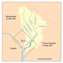 Map of the Anacostia River watershed showing Paint Branch | |
| Location | |
| Country | United States |
| Location | Montgomery and Prince George's counties, Maryland |
| Physical characteristics | |
| Mouth | |
• location | Northeast Branch Anacostia River |
| Length | 14.0 miles (22.5 km) |
| Basin size | 20.8 square miles (54 km2) |
Paint Branch is a 14.0-mile-long (22.5 km)[1] stream that flows through Montgomery County and Prince George's County, Maryland. It is a tributary of the Northeast Branch, which flows to the Anacostia River, Potomac River and the Chesapeake Bay.
The headwaters of Paint Branch are located near Spencerville (about 11.5 miles (18.5 km) north of Washington, D.C.) and the stream flows south for 14 miles (23 km) to its confluence with the Northeast Branch. The watershed area is 20.8 square miles (54 km2) and includes portions of the communities of Spencerville, Cloverly, Fairland, Colesville, White Oak and College Park.[2]
Tributaries[]
- Left Fork
- Right Fork
- Gum Springs Tributary
- Good Hope Tributary
- Snowden's Mill Branch
- Fairland Farms
- Columbia Park Tributary
- Hollywood Branch
- Martin Luther King Tributary
- Tanley Road Tributary
- Stewart-April Lane Tributary
- West Farm Branch
- Little Paint Branch
- Indian Creek
Recreation[]
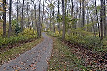
There are two trails along Paint Branch called Paint Branch Trail. One is a 3-mile hard surface trail in Montgomery County that runs from Martin Luther King Jr. Recreational Park to Fairland Road [3] with a trail extension in progress to take the trail to Old Columbia Pike.[4] The other is part of the Anacostia Tributary Trail System in Prince Georges County and goes from Lake Artemesia to Cherry Hill Road.[5]
See also[]
- List of Maryland rivers
References[]
- ^ U.S. Geological Survey. National Hydrography Dataset high-resolution flowline data. The National Map, accessed August 15, 2011
- ^ Anacostia Watershed Restoration Partnership. Washington, DC. "Paint Branch: Profile." Accessed 2009-09-16.
- ^ "Paint Branch Trail". Montgomery Parks. 2018-11-02. Retrieved 2020-10-27.
- ^ "Trail Extension Project in Paint Branch Stream Valley Park". Montgomery Parks. 2020-10-08. Retrieved 2020-10-27.
- ^ "Anacostia Tributary Trail System". Prince George's County: Parks And Recreation. Retrieved 2020-10-27.
External links[]
- Eyes of Paint Branch Community watershed organization
- Anacostia Riverkeeper
- Countywide Stream Protection Strategy: Paint Branch Watershed Montgomery County Dept. of Environmental Protection
- Anacostia Watershed Society
- Anacostia Watershed Restoration Partnership
- Paint Branch Trail Montgomery County Dept. of Parks
- Anacostia Tributary Trail System Prince George's County Dept. of Parks & Recreation
Coordinates: 38°58′43″N 76°55′00″W / 38.978722°N 76.916641°W

- Rivers of Montgomery County, Maryland
- Rivers of Prince George's County, Maryland
- Rivers of Maryland
- Anacostia River
- Maryland river stubs
- Montgomery County, Maryland geography stubs
- Prince George's County, Maryland geography stubs