Listed buildings in Faxe Municipality
This is a list of listed buildings in Faxe Municipality, Denmark.
List[]
4640 Faxe[]
| Listing name | Image | Location | Coordinates | Description |
|---|---|---|---|---|
| Blåbæk Watermill | Blåbækvej 5, 4640 Faxe |
55°14′16.12″N 12°7′0.28″E / 55.2378111°N 12.1167444°E | Residential wing[1] | |
| Blåbækvej 5, 4640 Faxe |
55°14′16.12″N 12°7′0.28″E / 55.2378111°N 12.1167444°E | Stampemølle[1] | ||
| Blåbækvej 5, 4640 Faxe |
55°14′16.12″N 12°7′0.28″E / 55.2378111°N 12.1167444°E | Barn[1] | ||
| Blåbækvej 5, 4640 Faxe |
55°14′16.12″N 12°7′0.28″E / 55.2378111°N 12.1167444°E | Watermill[1] | ||
| Blåbækvej 5, 4640 Faxe |
55°14′16.12″N 12°7′0.28″E / 55.2378111°N 12.1167444°E | Stable wing[1] | ||
| Blåbæk Windmill |  |
Blåbækvej 3, 4640 Faxe |
55°14′22.34″N 12°7′5.28″E / 55.2395389°N 12.1181333°E | Smock mill from 1838[2] |
| Fakse Ladeplads |  |
Strandvejen 98A, 4654 Faxe Ladeplads |
55°12′18.61″N 12°8′44.91″E / 55.2051694°N 12.1458083°E | [3] |
| Strandvejen 98A, 4654 Faxe Ladeplads |
55°12′18.61″N 12°8′44.91″E / 55.2051694°N 12.1458083°E | [4] | ||
| Jomfruens Egede |  |
Kirkevej 1A and 7, 4640 Faxe |
55°16′51.17″N 12°5′24″E / 55.2808806°N 12.09000°E | The main wing (south wing) from c. 1500-1550 which was lengthened westwards and strongly adapted in 1797 by C. F. Harsdorff and the cross wing from 1797 by C. F. Harsdorff[5] |
|
Kirkevej 1A and 7, 4640 Faxe |
55°16′51.17″N 12°5′24″E / 55.2808806°N 12.09000°E | Storage building (north wing) which probably dates from 1636 but has later been adapted[5] | |
| Lystrup |  |
Lystrupvej 9, 4640 Faxe |
55°15′42.77″N 12°3′49.73″E / 55.2618806°N 12.0638139°E | Renaissance-style manor house from 1579[6] |
| Prince Carl's School | Nordhøjvej 6, 4640 Faxe |
55°16′23.32″N 12°15′40.72″E / 55.2731444°N 12.2613111°E | Half-timbered building from 1719[7] | |
| Rosendal |  |
Rosendalvej 3, 4640 Faxe |
55°13′29.76″N 12°6′44.38″E / 55.2249333°N 12.1123278°E | [8] |
 |
Rosendalvej 3, 4640 Faxe |
55°13′29.76″N 12°6′44.38″E / 55.2249333°N 12.1123278°E | [8] | |
| Rosendalvej 3, 4640 Faxe |
55°13′29.76″N 12°6′44.38″E / 55.2249333°N 12.1123278°E | [8] | ||
| Rosendalvej 3, 4640 Faxe |
55°13′29.76″N 12°6′44.38″E / 55.2249333°N 12.1123278°E | [8] | ||
| Rasmus Svendsen's School | Nørregade 9, 4640 Faxe |
55°15′38.94″N 12°7′4.07″E / 55.2608167°N 12.1177972°E | Half-timbered building from 1641 with later extensions to the north and south as well as the surrounding cobbling[9] |

4653 Karise[]
| Listing name | Image | Location | Coordinates | Description |
|---|---|---|---|---|
| Karisse Church: The church barn |  |
Kildevej 1A, 4653 Karise |
55°18′20.81″N 12°12′33.31″E / 55.3057806°N 12.2092528°E | A church barn from circa 1500[10] |
4690 Haslev[]
| Listing name | Image | Location | Coordinates | Description |
|---|---|---|---|---|
| Bregentved | 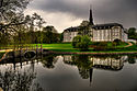 |
Moltkesvej 78, 4690 Haslev |
55°18′25.69″N 12°0′23.41″E / 55.3071361°N 12.0065028°E | The north wing from the 17th century which was adapted in circa 1740 aby and the interior chapel from 1735 by Lauritz de Thurah and Johann Friedrich Hännel[11] |
|
Moltkesvej 78, 4690 Haslev |
55°18′25.69″N 11°58′13.54″E / 55.3071361°N 11.9704278°E | The east and south wings from 1889-92 by Axel Berg[11] | |
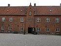
| Gisselfeld | 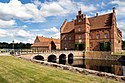 |
Gisselfeldvej 3, 4690 Haslev |
55°17′30.28″N 12°0′23.41″E / 55.2917444°N 12.0065028°E | Main building[12] |
 |
Gisselfeldvej 5, 4690 Haslev |
55°17′20.63″N 11°58′13.5″E / 55.2890639°N 11.970417°E | [12] | |
 |
Gisselfeldvej 5, 4690 Haslev |
55°17′20.63″N 11°58′13.5″E / 55.2890639°N 11.970417°E | [12] | |
| Turebyholm |  |
Turebyholmvej 14, 4682 Tureby |
55°21′46.85″N 12°5′2.16″E / 55.3630139°N 12.0839333°E | Ice house (cellar) topped by pavilion[13] |
| Turebyholmvej 16, 4682 Tureby |
55°20′50.87″N 12°5′34.35″E / 55.3474639°N 12.0928750°E | Manor house from 1750 by Niels Eigtved[13] |
References[]
- ^ a b c d e "FBB - sag".
- ^ "FBB - sag".
- ^ "Systemfejl".
- ^ "FBB - sag".
- ^ a b "FBB - sag".
- ^ "FBB - sag".
- ^ "FBB - sag".
- ^ a b c d "FBB - sag".
- ^ "FBB - sag".
- ^ "FBB - sag".
- ^ a b "FBB - sag".
- ^ a b c "FBB - sag".
- ^ a b "FBB - sag".
External links[]
| Wikimedia Commons has media related to Listed buildings in Faxe Kommune. |
Categories:
- Listed buildings and structures in Faxe Municipality
- Lists of listed buildings in Denmark