Listed buildings in Vordingborg Municipality
This is a list of listed buildings in Vordingborg Municipality, Denmark.
Listed buildings[]
- Note: This list is incomplete. A complete list of listed buildings in Vordingborg Municipality can be found on Danish Wikipedia.
4720 Præstø[]
| Listing name | Image | Location | Coordinates | Description |
|---|---|---|---|---|
| Adelgade 77 | Adelgade 77, 4720 Præstø | 55°7′20.88″N 12°2′35.91″E / 55.1224667°N 12.0433083°E | Townhouse from the middle of the 18th century which was extended with six bays in c. 1800 and expanded with an extra floor in 1842 and rebuilt in brick in the 1899s[1] | |
| Beldringe |  |
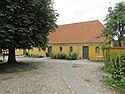
Hastrupvej 1, 4720 Præstø | 55°6′21.77″N 11°59′31.51″E / 55.1060472°N 11.9920861°E | Main building from 1561[2] |
| Hastrupvej 1, 4720 Præstø | 55°6′21.77″N 11°59′31.51″E / 55.1060472°N 11.9920861°E | Half-timbered barn from 1716[3] | ||
| Borgmestergården | 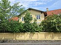 |
Grønnegade 1, 4720 Præstø | 55°7′23.32″N 12°2′30.68″E / 55.1231444°N 12.0418556°E | Former residence of the local mayor from 1723 with later changes and side and rear wings from 1826 [4] |
| Christinelund | Christinelundsvej 36, 4720 Præstø | 55°7′29.57″N 12°4′29.57″E / 55.1248806°N 12.0748806°E | Main building from 1859-60 designed by Ferdinand Meldahl[5] | |
| Christinelundsvej 38, 4720 Præstø | 55°7′8.56″N 12°4′29.57″E / 55.1190444°N 12.0748806°E | [6] | ||
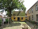
| Den Borgerlige Velgørenheds Stiftelse | 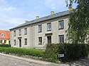 |
Jomfrustræde 8, 4720 Præstø | 55°7′25.97″N 12°2′45.64″E / 55.1238806°N 12.0460111°E | Building fronting the street from 1869 and wall on Klosternakken[7] |
 |
Jomfrustræde 8, 4720 Præstø | 55°7′25.97″N 12°2′45.64″E / 55.1238806°N 12.0460111°E | Side wing from 1870 and wall on Klosternakken[8] | |
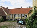
| Grundtvig House |  |
Torvestræde 7A, 4720 Præstø | 55°7′22.84″N 12°2′29.27″E / 55.1230111°N 12.0414639°E | Long, one-storey house with a three-bay wall dormer above the gate[9] |
 |
Torvestræde 7D, 4720 Præstø | 55°7′22.94″N 12°2′29.27″E / 55.1230389°N 12.0414639°E | Rear wing from 1821[10] | |
 |
Torvestræde 7, 4720 Præstø | 55°7′22.48″N 12°2′29.27″E / 55.1229111°N 12.0414639°E | Side wing from 1826[11] | |
| Grønnegade 9 |  |
Grønnegade 9, 4720 Præstø | 55°7′24.03″N 12°2′33.17″E / 55.1233417°N 12.0425472°E | Townhouse from 1859[12] |
| Grønnegade 11 |  |
Grønnegade 11, 4720 Præstø | 55°7′24.18″N 12°2′33.78″E / 55.1233833°N 12.0427167°E | Townhouse from 1859, the eastern side wing from 1859 and the western side wing from 1871[13] |
| Grønnegade 12 |  |
Grønnegade 12, 4720 Præstø | 55°7′23.58″N 12°2′33.75″E / 55.1232167°N 12.0427083°E | A former wood workshop from 1855 converted into a townhouse in 1874[14] |
| H.C. Olsens Pakhus |  |
Havnepladsen 8, 4720 Præstø | 55°7′26.87″N 12°2′31.39″E / 55.1241306°N 12.0420528°E | Warehouse from 1898[15] |
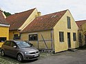
| Havnestræde 2, 4 B-C |  |
Havnestræde 2, 4720 Præstø | 55°7′17.05″N 12°2′21.24″E / 55.1214028°N 12.0392333°E | Side wing along Havnestræde from 1856[16] |
| Havnepladsen 12 |  |
Havnepladsen 12, 4720 Præstø | 55°7′28.11″N 12°2′34.47″E / 55.1244750°N 12.0429083°E | Warehouse from 1842[17] |
| Klosternakken 1 | 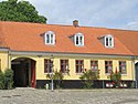 |
Klosternakken 1, 4720 Præstø | 55°7′26.88″N 12°2′44.72″E / 55.1241333°N 12.0457556°E | Townhouse with side wing from 1857[18] |
| Klosternakken 3 |  |
Klosternakken 3, 4720 Præstø | 55°7′27.05″N 12°2′45.5″E / 55.1241806°N 12.045972°E | Townhouse from 1857 by M. S. Miede[19] |
| Klosternakken 5 |  |
Klosternakken 3, 4720 Præstø | 55°7′27.16″N 12°2′46.09″E / 55.1242111°N 12.0461361°E | Townhouse from 1857 by M. S. Miede[20] |
| Nysø Manor |  |
Nysøvej 3, 4720 Præstø | | Gate wing | Ref |
| Nysøvej 1, 4720 Præstø | 1673 | Stables (eastern) | Ref | |
| Nysøvej 1, 4720 Præstø | 1673 | Stables (western) | Ref | |
 |
Nysøvej 3, 4720 Præstø | 1839 | Pavillon | Ref |
 |
Nysøvej 1, 4720 Præstø | 1910 | Barn[21] | |
| Oremandsgårds Husflidsskole | Kragevigvej 13, 4720 Præstø | 55°4′22.14″N 12°5′51.61″E / 55.0728167°N 12.0976694°E | School building from 1872[22] | |
| Præstø Technical School | 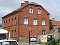 |
Jomfrustræde 4, 4720 Præstø | 55°7′24.15″N 12°2′46.57″E / 55.1233750°N 12.0462694°E | School building from 1781 designed by Frederik Wilsbech[23] |
 |
Rødeledvej 1, 4720 Præstø | 55°7′10.78″N 12°1′32.49″E / 55.1196611°N 12.0256917°E | Pottery from 1897ref>https://www.kulturarv.dk/fbb/sagvis.pub?sag=10745208</ref> | |
| Rødeledvej 1, 4720 Præstø | 55°7′10.78″N 12°1′32.49″E / 55.1196611°N 12.0256917°E | Pottery from 1897[24] | ||
| Rødeledvej 1, 4720 Præstø | 55°7′10.78″N 12°1′32.49″E / 55.1196611°N 12.0256917°E | Pottery from 1897[25] | ||
| Rødeledvej 1, 4720 Præstø | 55°7′10.78″N 12°1′32.49″E / 55.1196611°N 12.0256917°E | Pottery from 1897[26] | ||
| Sølyst | Havnevej 15, 4720 Præstø | 55°7′24.19″N 12°2′26.06″E / 55.1233861°N 12.0405722°E | Building from 1858[27] | |
| Torvet 5 |  |
Torvet 5, 4720 Præstø | 55°7′25.01″N 12°2′36.1″E / 55.1236139°N 12.043361°E | Building from 1854[28] |
| Torvet 7 |  |
Torvet 7, 4720 Præstø | 55°7′25.18″N 12°2′36.73″E / 55.1236611°N 12.0435361°E | Building from 1819 whose facade and one of the gables were rebuilt in brick in 1846[29] |
| Torvet 9 |  |
Torvet 9, 4720 Præstø | 55°7′25.49″N 12°2′37.75″E / 55.1237472°N 12.0438194°E | Building from before 1738 which was rebuilt in brick in the 19th century and side wing from 1885[30] |
| Præstø Town Hall and Jailhouse |  |
Torvet 10, 4720 Præstø | 55°7′24.62″N 12°2′38.32″E / 55.1235056°N 12.0439778°E | Former town hall built in 1823 to a design from c. 1803 by Willads Stilling and Christian Frederik Hansen which was later expanded and altered in 1868 as well as the jailhouse from 1850[31] |
| Skovly | Kragevigvej 17, 4720 Præstø | [32] | ||
| Kragevigvej 17, 4720 Præstø | [33] | |||
| Kragevigvej 17, 4720 Præstø | [34] | |||
| Kragevigvej 17, 4720 Præstø | [35] | |||
| Torvet 11 |  |
Torvet 11, 4720 Præstø | 55°7′25.6″N 12°2′38.39″E / 55.123778°N 12.0439972°E | Building from 1845[36] |
| Torvet 12 | 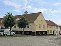 |
Torvet 12, 4720 Præstø | 55°7′24.7″N 12°2′39.96″E / 55.123528°N 12.0444333°E | Townhouse from 1854 and side wing from 1856 which was heightened in 1867[37] |
| Torvet 19 | Torvet 19, 4720 Præstø | [38] | ||
| Torvet 20 |  |
Torvet 20, 4720 Præstø | 55°7′25.34″N 12°2′42.94″E / 55.1237056°N 12.0452611°E | Townhouse from 1744 which was altered in 1832[39] |
| Torvet 21 |  |
Torvet 21, 4720 Præstø | [40] | |
| Torvet 23 | 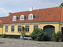 |
Torvet 23, 4720 Præstø | 55°7′26.71″N 12°2′43.9″E / 55.1240861°N 12.045528°E | Townhouse from c. 1853 by M.S. Miede and side wing from c. 1900[41] |
| Torbet 24 |  |
Torvet 24, 4720 Præstø | 55°7′25.55″N 12°2′43.74″E / 55.1237639°N 12.0454833°E | Building from 1913[42] |
4735 Mern[]
| Listing name | Image | Location | Coordinates | Description |
|---|---|---|---|---|
| Øster Egesborg Kirkelade | Øster Egesborgvej 6, 4735 Mern | [43] |
4750 Lundby[]
| Listing name | Image | Location | Coordinates | Description |
|---|---|---|---|---|
| Gammel Øbjerggård | Bygaden 27, 4750 Lundby | 55°6′35.14″N 11°49′32.42″E / 55.1097611°N 11.8256722°E | Main building from c. 1780[44] | |
| Køng Hospital | Bygaden 16, 4750 Lundby | 55°6′35.29″N 11°49′38.59″E / 55.1098028°N 11.8273861°E | Hospital building from 1793[45] | |
| Lundbygård | Lundbygårdsvej 100, 4750 Lundby | 55°7′33.48″N 11°53′45.79″E / 55.1259667°N 11.8960528°E | Three-winged main building from 1806[46] | |
| Spindeskolen, Køng | Bygaden 22, 4750 Lundby | 55°6′37.7″N 11°49′32.65″E / 55.110472°N 11.8257361°E | School building from 1780[47] | |
| Udby Rectory | Spangsvej 174, 4750 Lundby | 55°4′33.29″N 11°55′54.83″E / 55.0759139°N 11.9318972°E | [48] | |
| Spangsvej 174, 4750 Lundby | 55°4′33.29″N 11°55′54.83″E / 55.0759139°N 11.9318972°E | [49] | ||
| Spangsvej 174, 4750 Lundby | 55°4′33.29″N 11°55′54.83″E / 55.0759139°N 11.9318972°E | [50] | ||
| Spangsvej 174, 4750 Lundby | 55°4′33.29″N 11°55′54.83″E / 55.0759139°N 11.9318972°E | [51] |
4760 Vordingborg[]
| Listing name | Image | Location | Coordinates | Description |
|---|---|---|---|---|
| Det gamle Sprøjtehus | Slotstorvet 5, 4760 Vordingborg | 55°0′27.67″N 11°54′36.84″E / 55.0076861°N 11.9102333°E | Fire station from 1854[52] | |
| Gåsetårnet |  |
Slotstorvet 9, 4760 Vordingborg | 55°00′25.27″N 11°54′39.23″E / 55.0070194°N 11.9108972°E | [53] |
| Færgegaardsvej 15, 4760 Vordingborg | 55°0′0.37″N 11°54′39.98″E / 55.0001028°N 11.9111056°E | Hospital complex from 1854-57 by Gottlieb Bindesbøll[54] | ||
| Færgegaardsvej 15, 4760 Vordingborg | 55°0′0.37″N 11°54′39.98″E / 55.0001028°N 11.9111056°E | Hospital complex from 1854-57 by Gottlieb Bindesbøll[55] | ||
| Færgegaardsvej 15, 4760 Vordingborg | 55°0′0.37″N 11°54′39.98″E / 55.0001028°N 11.9111056°E | Hospital complex from 1854-57 by Gottlieb Bindesbøll[56] | ||
| Færgegaardsvej 15, 4760 Vordingborg | 55°0′0.37″N 11°54′39.98″E / 55.0001028°N 11.9111056°E | Hospital complex from 1854-57 by Gottlieb Bindesbøll[57] | ||
| Færgegaardsvej 15, 4760 Vordingborg | 55°0′0.37″N 11°54′39.98″E / 55.0001028°N 11.9111056°E | Hospital complex from 1854-57 by Gottlieb Bindesbøll[58] | ||
| Færgegaardsvej 15, 4760 Vordingborg | 55°0′0.37″N 11°54′39.98″E / 55.0001028°N 11.9111056°E | Hospital complex from 1854-57 by Gottlieb Bindesbøll[59] | ||
| Færgegaardsvej 15, 4760 Vordingborg | 55°0′0.37″N 11°54′39.98″E / 55.0001028°N 11.9111056°E | Hospital complex from 1854-57 by Gottlieb Bindesbøll[60] | ||
| Færgegaardsvej 15, 4760 Vordingborg | 55°0′0.37″N 11°54′39.98″E / 55.0001028°N 11.9111056°E | Hospital complex from 1854-57 by Gottlieb Bindesbøll[61] | ||
| Færgegaardsvej 15, 4760 Vordingborg | 55°0′0.37″N 11°54′39.98″E / 55.0001028°N 11.9111056°E | Hospital complex from 1854-57 by Gottlieb Bindesbøll[62] | ||
| Færgegaardsvej 15, 4760 Vordingborg | 55°0′0.37″N 11°54′39.98″E / 55.0001028°N 11.9111056°E | Hospital complex from 1854-57 by Gottlieb Bindesbøll[63] | ||
| Færgegaardsvej 15, 4760 Vordingborg | 55°0′0.37″N 11°54′39.98″E / 55.0001028°N 11.9111056°E | Hospital complex from 1854-57 by Gottlieb Bindesbøll[64] | ||
| Rosenfeldt Manor |  |
Rosenfeldt 1, 4760 Vordingborg | 55°1′0.59″N 11°52′34.4″E / 55.0168306°N 11.876222°E | Main building from 1868-70 by [65] |
| Rosenfeldt 1, 4760 Vordingborg | 55°1′0.59″N 11°52′34.4″E / 55.0168306°N 11.876222°E | Barn from 1776-77 by Christian Joseph Zuber on the north side of the octagonal courtyard[66] | ||
| Rosenfeldt 1, 4760 Vordingborg | 55°1′0.59″N 11°52′34.4″E / 55.0168306°N 11.876222°E | Stables from 1776-77 by Christian Joseph Zuber on the north side of the octagonal courtyard[67] | ||
| Rosenfeldt 1, 4760 Vordingborg | 55°1′0.59″N 11°52′34.4″E / 55.0168306°N 11.876222°E | Farm building from 1776-77 by Christian Joseph Zuber on the northwest side of the octagonal courtyard[68] | ||
| Rosenfeldt 1, 4760 Vordingborg | 55°1′0.59″N 11°52′34.4″E / 55.0168306°N 11.876222°E | Dairy from 1776-77 by Christian Joseph Zuber on the north side of the octagonal courtyard[69] | ||
| Rosenfeldt 2, 4760 Vordingborg | 55°1′1.9″N 11°52′34.4″E / 55.017194°N 11.876222°E | Residential building from 1776-77 by Christian Joseph Zuber on the south side of the octagonal courtyard[70] | ||
| Rosenfeldt 3, 4760 Vordingborg | 55°1′4.48″N 11°52′34.4″E / 55.0179111°N 11.876222°E | Residential building from 1776-77 by Christian Joseph Zuber on the northeastern side of the octagonal courtyard[71] | ||
| Snertingegård | Fæbyvej 121, 4760 Vordingborg | 55°3′50.35″N 11°55′9.83″E / 55.0639861°N 11.9193972°E | Main building from 1857 by [72] | |
| Fæbyvej 121, 4760 Vordingborg | 55°3′50.35″N 11°55′9.83″E / 55.0639861°N 11.9193972°E | [73] | ||
| Fæbyvej 123, 4760 Vordingborg | 55°3′51.41″N 11°55′9.83″E / 55.0642806°N 11.9193972°E | [74] | ||
| Vordingborg Tpwn Hall |  |
Algade 97, 4760 Vordingborg | [75] | |
| Ørslev Kirkelade | Ørslevvej 134, 4760 Vordingborg | [76] |
4772 Langebæk []
| Listing name | Image | Location | Coordinates | Description |
|---|---|---|---|---|
| Ore Lighthouse | 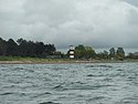 |
Petersværft 4, 4772 Langebæk | 55°0′24.7″N 11°52′11.3″E / 55.006861°N 11.869806°E | [77] |
| Petersgaard | Petersgaard Alle 3, 4772 Langebæk | 55°0′10.88″N 12°6′10.94″E / 55.0030222°N 12.1030389°E | Lighthouse from 1895 by Theodor Wedén[78] | |
| Petersværft 2: Skovfogedstedet | Petersværft 2, 4772 Langebæk | 54°58′14.21″N 12°4′28.61″E / 54.9706139°N 12.0746139°E | One-storey, thatched house from 1905 which was extended in 1916, probably by Viggo Dahl[79] | |
| Petersværft 2, 4772 Langebæk | 54°58′14.21″N 12°4′28.61″E / 54.9706139°N 12.0746139°E | One-storey, thatched outbuilding[80] | ||
| Petersværft 3: Skovridergården | Petersværft 2, 4772 Langebæk | 54°58′15.38″N 12°4′33.63″E / 54.9709389°N 12.0760083°E | One-storey, L-shaped brick building with tile roof from c. 1800 which was adapted in 1928[81] | |
| Petersværft 2, 4772 Langebæk | 54°58′15.38″N 12°4′33.63″E / 54.9709389°N 12.0760083°E | L-shaped, half-timbered, thatched barn from c. 1800[82] | ||
| Petersværft 4: Officershuset | Petersværft 4, 4772 Langebæk | 54°58′19.31″N 12°4′41.87″E / 54.9720306°N 12.0782972°E | One-storey, L-shaped brick building with half hipped red tile roof over high cellar from 1807 which was expanded in 1885 and again in 1903[83] | |
| Petersværft 5: Skovkuskeboligen og Den gl. Forpagterbolig, Petersværft | Petersværft 5A, 4772 Langebæk | 54°58′15.7″N 12°4′34.91″E / 54.971028°N 12.0763639°E | One-storey, thatched house with half-timbered gables from the late 18th century[84] |
4791 Borre[]
| Listing name | Image | Location | Coordinates | Description |
|---|---|---|---|---|
| Magleby Rectory | Klintevej 502, 4791 Borre | 54°59′2.26″N 12°29′5.57″E / 54.9839611°N 12.4848806°E | Residential wing from 1849[85] | |
| Klintevej 502, 4791 Borre | 54°59′2.26″N 12°29′5.57″E / 54.9839611°N 12.4848806°E | Attached outbuilding from 1849[86] | ||
| Klintevej 502, 4791 Borre | 54°59′2.26″N 12°29′5.57″E / 54.9839611°N 12.4848806°E | Attached outbuilding from 1849[87] |
4780 Stege[]
| Listing name | Image | Location | Coordinates | Description | |
|---|---|---|---|---|---|
| Hage House |  |
Storegade 4A, 4780 Stege | 54°58′57.82″N 12°16′59.92″E / 54.9827278°N 12.2833111°E | Building on Storegade with side wing on Billedhuggerstræde, dating from 1816 except for the four easternmost bays which are from 1845[88] | |
| Hage House: Billedhuggerstræde 2 |  |
Billedhuggerstræde 2, 4780 Stege | 54°58′58″N 12°17′1.76″E / 54.98278°N 12.2838222°E | Building on Storegade with side wing on Billedhuggerstræde, dating from 1816 except for the four easternmost bays which are from 1845[89] | |
| Liselund |  |
Langebjergvej 4, 4791 Borre | 1792 | Liselund House | 1 |
 |
Langebjergvej 4, 4791 Borre | 1790 | Chinese pavilion | 390-7746-5 | |
 |
Langebjergvej 4, 4791 Borre | 1790 | Norwegian House | 390-7746-4 | |
 |
Langebjergvej 4, 4791 Borre | 1790 | Swiss Cottage | 390-7746-2 | |
 |
Langebjergvej 6, 4791 Borre | 1887 | Liselund Ny Slot | 390-11318-1 | |
| Langebjergvej 8, 4791 Borre | 1790 | 390-10934-6 | |||
| Langebjergvej 8, 4791 Borre | 1790 | 390-10934-8 | |||
| Langebjergvej 8, 4791 Borre | 1790 | 390-10934-8 | |||
| Kammerrådgården |  |
Storegade 35A, 4780 Stege | 54°59′5.59″N 12°17′5.83″E / 54.9848861°N 12.2849528°E | Building on Storegade from c. 1770 whose facade was altered in c. 1800[90] | |
 |
Storegade 35D, 4780 Stege | 54°59′6.05″N 12°17′5.83″E / 54.9850139°N 12.2849528°E | Rear wing with exposed timber framing[91] | ||
 |
Storegade 35K, 4780 Stege | 54°59′6.69″N 12°17′5.83″E / 54.9851917°N 12.2849528°E | Warehouse[92] | ||
 |
Storegade 35L, 4780 Stege | 54°59′6.05″N 12°17′5.83″E / 54.9850139°N 12.2849528°E | Stables[93] | ||
| Klintholm Manor | Klintholm Alle 1A, 4791 Borre | 54°58′43.45″N 12°30′12.59″E / 54.9787361°N 12.5034972°E | [94] | ||
| Mølleporten |  |
Storegade 75A, 4780 Stege | 54°59′13.95″N 12°17′21.44″E / 54.9872083°N 12.2892889°E | Gate tower from c. 1480-1500[95] | |
| Møns Museum |  |
Storegade 75, 4780 Stege | 54°59′13.52″N 12°17′20.31″E / 54.9870889°N 12.2889750°E | Four-winged complex from 1813 and two half-timbered buildings[96] | |
 |
Storegade 75, 4780 Stege | 54°59′13.52″N 12°17′20.31″E / 54.9870889°N 12.2889750°E | Four-winged complex from 1813 and two half-timbered buildings[97] | ||
 |
Storegade 75, 4780 Stege | 54°59′13.52″N 12°17′20.31″E / 54.9870889°N 12.2889750°E | Four-winged complex from 1813 and two half-timbered buildings[98] | ||
 |
Storegade 75, 4780 Stege | 54°59′13.52″N 12°17′20.31″E / 54.9870889°N 12.2889750°E | Four-winged complex from 1813 and two half-timbered buildings[99] | ||
 |
Storegade 75, 4780 Stege | 54°59′13.52″N 12°17′20.31″E / 54.9870889°N 12.2889750°E | Four-winged complex from 1813 and two half-timbered buildings[100] | ||
| Museumsgården ved Keldbylille | Skullebjergvej 15, 4780 Stege | [101] | |||
| Skullebjergvej 15, 4780 Stege | [102] | ||||
| Skullebjergvej 15, 4780 Stege | [103] | ||||
| Skullebjergvej 15, 4780 Stege | [104] | ||||
| Skullebjergvej 15, 4780 Stege | [105] | ||||
| Skullebjergvej 15, 4780 Stege | [106] | ||||
| Skullebjergvej 15, 4780 Stege | [107] | ||||
| Skullebjergvej 15, 4780 Stege | [108] | ||||
| Nordfeld | Nordfeldvej 48, 4780 Stege | 55°1′9.55″N 12°23′40.3″E / 55.0193194°N 12.394528°E | The residential north wing of avlsgård[109] | ||
| Nordfeldvej 48A, 4780 Stege | Part of the east wing of avlsgård with stables[110] | ||||
| Nordfeldvej 50, 4780 Stege | 55°1′19.21″N 12°23′40.3″E / 55.0220028°N 12.394528°E | [111] | |||
| Nordfeldvej 50, 4780 Stege | 55°1′19.21″N 12°23′40.3″E / 55.0220028°N 12.394528°E | [112] | |||
| Nordfeldvej 50, 4780 Stege | 55°1′19.21″N 12°23′40.3″E / 55.0220028°N 12.394528°E | [113] | |||
| Nordfeldvej 50, 4780 Stege | 55°1′19.21″N 12°23′40.3″E / 55.0220028°N 12.394528°E | [114] | |||
| Nordfeldvej 50, 4780 Stege | 55°1′19.21″N 12°23′40.3″E / 55.0220028°N 12.394528°E | [115] | |||
| Nordfeldvej 50, 4780 Stege | 55°1′19.21″N 12°23′40.3″E / 55.0220028°N 12.394528°E | [116] | |||
| Nordfeldvej 52, 4780 Stege | 55°1′19.21″N 12°23′40.3″E / 55.0220028°N 12.394528°E | Rwo-storey brick house[117] | |||
| Nordfeldvej 54, 4780 Stege | 55°1′19.63″N 12°23′40.3″E / 55.0221194°N 12.394528°E | One-storey thatched brick house[118] | |||
| Nordfeldvej 56, 4780 Stege | 55°1′20.67″N 12°23′40.3″E / 55.0224083°N 12.394528°E | Thatched outbuilding with exposed timber framing[119] | |||
| Nybøllegård | Grønsundvej 50, 4780 Stege | 54°58′17.83″N 12°15′26.74″E / 54.9716194°N 12.2574278°E | Country house from 1856 by Gottlieb Bindesbøll[120] | ||
| Nyord: Nordgade 7 | 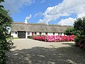 |
Nordgade 7, 4780 Stege | 55°2′30.68″N 12°11′45.22″E / 55.0418556°N 12.1958944°E | Three-wined farm from the 18th century[121] | |
| Nyord: Nordgade 9 |  |
Nordgade 7, 4780 Stege | 55°2′29.98″N 12°11′45.5″E / 55.0416611°N 12.195972°E | Half-rimbered building from the 19th century[122] | |
| Nyord: Østergade 7 and Nordgade 11, Nyord |  |
Østergade 7, 4780 Stege | 55°2′29.91″N 12°11′47.3″E / 55.0416417°N 12.196472°E | Half-timbered house from the 19th century[123] | |
 |
Nordgade 11, 4780 Stege | 55°2′29.93″N 12°11′47.3″E / 55.0416472°N 12.196472°E | Half-timbered house from the 19th century[124] | ||
| Østergade 9 | Østergade 9, 4780 Stege | [125] | |||
| Østergade 9, 4780 Stege | [126] | ||||
| Østergade 9, 4780 Stege | [127] | ||||
| Østergade 9, 4780 Stege | [128] | ||||
| Østergade 9, 4780 Stege | [129] | ||||
| Rødkilde Højskole |  |
Rødkildevej 42A, 4780 Stege | 54°58′6.52″N 12°16′10.15″E / 54.9684778°N 12.2694861°E | Octagonal assembly building from 1878 bu Povlsen Nørbjerg[130] | |
 |
Rødkildevej 42D, 4780 Stege | 54°58′8.9″N 12°16′10.15″E / 54.969139°N 12.2694861°E | Main building from 1866 by Ludvig Fenger[131] | ||
| Rødkildevej 42E, 4780 Stege | 54°58′6.05″N 12°16′10.15″E / 54.9683472°N 12.2694861°E | Residential quarters for students from 1866 by Ludvig Fenger[132] | |||
 |
Provstestræde 2, 4780 Stege | 54°59′1.82″N 12°17′1.04″E / 54.9838389°N 12.2836222°E | L-shaped building from the Late Middle Ages[133] | ||
 |
Provstestræde 2, 4780 Stege | 54°59′1.82″N 12°17′1.04″E / 54.9838389°N 12.2836222°E | Outbuilding from c. 1830[134] | ||
| Stege Pharmacy |  |
Storegade 48, 4780 Stege | 54°59′6.42″N 12°17′10.04″E / 54.9851167°N 12.2861222°E | The building on the street from 1688, a side wing from 1889 and the cobbled courtyard[135] | |
| Stege Rampart | Møllebrøndstræde 0, 4780 Stege | [136] | |||
| Stege Rectory | Dybsbrostræde 1, 4780 Steg | [137] | |||
| Stege Town Hall |  |
Storegade 39, 4780 Stege | 54°58′57.82″N 12°16′59.92″E / 54.9827278°N 12.2833111°E | Former town hall from 1853-54 by Gottlieb Bindesbøll[138] | |
| Storegade 88 | Storegade 88C, 4780 Stege | [139] |
[]
| Listing name | Image | Location | Coordinates | Description |
|---|---|---|---|---|
| Bogø Windmill | 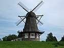 |
Bogø Hovedgade 36, 4793 Bogø By | 54°55′8.26″N 12°3′0.15″E / 54.9189611°N 12.0500417°E | Smock mill from 1852[140] |
| Bogø Møllegård |  |
Bogø Hovedgade 36, 4793 Bogø By | 54°55′11.93″N 12°2′56.63″E / 54.9199806°N 12.0490639°E | Miller's house from c. 1790[141] |
Delisted buildings[]
| Listing name | Image | Location | Coordinates | Description |
|---|---|---|---|---|
| Bogø Navigation School |  |
Bogø Hovedgade 140A, 4793 Bogø By | 54°55′45.27″N 12°2′53.53″E / 54.9292417°N 12.0482028°E | School building from c. 1885[142] |
| Klosterly |  |
Adelgade 119, 4720 Præstø | 55°7′23.15″N 12°2′48.5″E / 55.1230972°N 12.046806°E | Building from 1882[143] |
 |
Adelgade 119B, 4720 Præstø | 55°7′24.25″N 12°2′48.5″E / 55.1234028°N 12.046806°E | Rear wing from 1882[144] | |
| Stege Nursing Home | Langgade 59A, 4780 Stege | 54°59′16.09″N 12°16′56.36″E / 54.9878028°N 12.2823222°E | Wing on Langgade built as a navigation school in 1703[145] | |
| Torvet 19 |  |
Torvet 19, 4720 Præstø | 55°7′26.4″N 12°2′42.43″E / 55.124000°N 12.0451194°E | Townhouse from 1853 by M.S. Miede[146] |
| Torbet 21 | |
Torvet 21, 4720 Præstø | 55°7′26.58″N 12°2′43.22″E / 55.1240500°N 12.0453389°E | House from 1853 by M.S. Miede[147] |
References[]
- ^ "FBB - sag".
- ^ "FBB - sag".
- ^ "FBB - sag".
- ^ "FBB - sag".
- ^ "FBB - sag".
- ^ "FBB - sag".
- ^ "FBB - sag".
- ^ "FBB - sag".
- ^ "FBB - sag".
- ^ "FBB - sag".
- ^ "FBB - sag".
- ^ "FBB - sag".
- ^ "FBB - sag".
- ^ "FBB - sag".
- ^ "FBB - sag".
- ^ "FBB - sag".
- ^ "FBB - sag".
- ^ "FBB - sag".
- ^ "FBB - sag".
- ^ "FBB - sag".
- ^ "FBB - Bygning".
- ^ "FBB - sag".
- ^ "FBB - sag".
- ^ "FBB - sag".
- ^ "FBB - sag".
- ^ "FBB - sag".
- ^ "FBB - sag".
- ^ "FBB - sag".
- ^ "FBB - sag".
- ^ "FBB - sag".
- ^ "FBB - sag".
- ^ "FBB - sag".
- ^ "FBB - sag".
- ^ "FBB - sag".
- ^ "FBB - sag".
- ^ "FBB - sag".
- ^ "FBB - sag".
- ^ "FBB - sag".
- ^ "FBB - sag".
- ^ "FBB - sag".
- ^ "FBB - sag".
- ^ "FBB - sag".
- ^ "FBB - sag".
- ^ "FBB - sag".
- ^ "FBB - sag".
- ^ "FBB - sag".
- ^ "FBB - sag".
- ^ "FBB - sag".
- ^ "FBB - sag".
- ^ "FBB - sag".
- ^ "FBB - sag".
- ^ "FBB - sag".
- ^ "FBB - sag".
- ^ "FBB - sag".
- ^ "FBB - sag".
- ^ "FBB - sag".
- ^ "FBB - sag".
- ^ "FBB - sag".
- ^ "FBB - sag".
- ^ "FBB - sag".
- ^ "FBB - sag".
- ^ "FBB - sag".
- ^ "FBB - sag".
- ^ "FBB - sag".
- ^ "FBB - sag".
- ^ "FBB - sag".
- ^ "FBB - sag".
- ^ "FBB - sag".
- ^ "FBB - sag".
- ^ "FBB - sag".
- ^ "FBB - sag".
- ^ "FBB - sag".
- ^ "FBB - sag".
- ^ "FBB - sag".
- ^ "FBB - sag".
- ^ "FBB - sag".
- ^ "FBB - sag".
- ^ "FBB - sag".
- ^ "FBB - sag".
- ^ "FBB - sag".
- ^ "FBB - sag".
- ^ "FBB - sag".
- ^ "FBB - sag".
- ^ "FBB - sag".
- ^ "FBB - sag".
- ^ "FBB - sag".
- ^ "FBB - sag".
- ^ "FBB - sag".
- ^ "FBB - sag".
- ^ "FBB - sag".
- ^ "FBB - sag".
- ^ "FBB - sag".
- ^ "FBB - sag".
- ^ "FBB - sag".
- ^ "FBB - sag".
- ^ "FBB - sag".
- ^ "FBB - sag".
- ^ "FBB - sag".
- ^ "FBB - sag".
- ^ "FBB - sag".
- ^ "FBB - sag".
- ^ "FBB - sag".
- ^ "FBB - sag".
- ^ "FBB - sag".
- ^ "FBB - sag".
- ^ "FBB - sag".
- ^ "FBB - sag".
- ^ "FBB - sag".
- ^ "FBB - sag".
- ^ "FBB - sag".
- ^ "FBB - sag".
- ^ "FBB - sag".
- ^ "FBB - sag".
- ^ "FBB - sag".
- ^ "FBB - sag".
- ^ "FBB - sag".
- ^ "FBB - sag".
- ^ "FBB - sag".
- ^ "FBB - sag".
- ^ "FBB - sag".
- ^ "FBB - sag".
- ^ "FBB - sag".
- ^ "FBB - sag".
- ^ "FBB - sag".
- ^ "FBB - sag".
- ^ "FBB - sag".
- ^ "FBB - sag".
- ^ "FBB - sag".
- ^ "FBB - sag".
- ^ "FBB - sag".
- ^ "FBB - sag".
- ^ "FBB - sag".
- ^ "FBB - sag".
- ^ "FBB - sag".
- ^ "FBB - sag".
- ^ "FBB - sag".
- ^ "FBB - sag".
- ^ "FBB - sag".
- ^ "FBB - sag".
- ^ "FBB - sag".
- ^ "FBB - sag".
- ^ "FBB - sag".
- ^ "FBB - sag".
- ^ "FBB - sag".
- ^ "FBB - sag".
- ^ "FBB - sag".
- ^ "FBB - sag".
External links[]
| Wikimedia Commons has media related to Listed buildings in Vordingborg Kommune. |
Categories:
- Listed buildings and structures in Vordingborg Municipality
- Lists of listed buildings in Denmark