Littenseradiel
Littenseradiel
Littenseradeel | |
|---|---|
Municipality | |
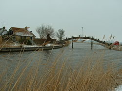 Canal through Wjelsryp | |
 Flag  Coat of arms | |
 Location in Friesland | |
| Coordinates: 53°7′N 5°35′E / 53.117°N 5.583°ECoordinates: 53°7′N 5°35′E / 53.117°N 5.583°E | |
| Country | Netherlands |
| Province | Friesland |
| Established | 1 January 1984 |
| Government | |
| • Body | Municipal council |
| • Mayor | (PvdA) |
| Area | |
| • Total | 132.64 km2 (51.21 sq mi) |
| • Land | 130.75 km2 (50.48 sq mi) |
| • Water | 1.89 km2 (0.73 sq mi) |
| Elevation | 1 m (3 ft) |
| Time zone | UTC+1 (CET) |
| • Summer (DST) | UTC+2 (CEST) |
| Postcode | Parts of 8000 and 9000 range |
| Area code | 0515, 0517, 058 |
| Website | www |

Littenseradiel (![]() West Frisian) is a former municipality in the northern Netherlands, known in Dutch as Littenseradeel (pronounced [ˈlɪtə(n)səraːˌdeːl] (
West Frisian) is a former municipality in the northern Netherlands, known in Dutch as Littenseradeel (pronounced [ˈlɪtə(n)səraːˌdeːl] (![]() listen)). The municipality was formed on 1 January 1984 by a merger of the former municipalities Baarderadeel and Hennaarderadeel. On 1 January 2018, the municipality was dissolved and its territory was split between three other municipalities: Waadhoeke, which was established that day, Leeuwarden and Súdwest-Fryslân.
listen)). The municipality was formed on 1 January 1984 by a merger of the former municipalities Baarderadeel and Hennaarderadeel. On 1 January 2018, the municipality was dissolved and its territory was split between three other municipalities: Waadhoeke, which was established that day, Leeuwarden and Súdwest-Fryslân.
Population centers[]
Baaium, Baard, Bears, Boazum, Britswert, Easterlittens, Easterwierrum, Hidaard, Hilaard, Hinnaard, Húns, Iens, Itens, Jellum, Jorwert, Kûbaard, Leons, Lytsewierrum, Mantgum, Reahûs, Rien, Spannum, Waaksens, Weidum, Winsum, Wiuwert, Wjelsryp, Wommels.
Topography[]

Dutch topographic map of the municipality of Littenseradiel, June 2015
References[]
- ^ "Samenstelling en taken van college b en w" [Members and tasks of the board of mayor and aldermen] (in Dutch). Gemeente Littenseradiel. Archived from the original on 23 September 2013. Retrieved 21 September 2013.
- ^ "Kerncijfers wijken en buurten 2020" [Key figures for neighbourhoods 2020]. StatLine (in Dutch). CBS. 24 July 2020. Retrieved 19 September 2020.
- ^ "Postcodetool for 8731BN". Actueel Hoogtebestand Nederland (in Dutch). Het Waterschapshuis. Archived from the original on 21 September 2013. Retrieved 21 September 2013.
- ^ "Bevolkingsontwikkeling; regio per maand" [Population growth; regions per month]. CBS Statline (in Dutch). CBS. 1 January 2019. Retrieved 1 January 2019.
External links[]
 Media related to Littenseradiel at Wikimedia Commons
- Official website
| show Neighbouring municipalities at time of dissolution |
|---|
| show Authority control |
|---|
This Friesland location article is a stub. You can help Wikipedia by . |
- Leeuwarden
- Súdwest-Fryslân
- Waadhoeke
- Former municipalities of Friesland
- States and territories established in 1984
- Populated places disestablished in 2018
- Friesland geography stubs