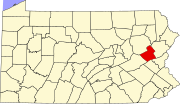
Little Gap, Pennsylvania
This article needs additional citations for verification. (September 2019) |
Little Gap, Pennsylvania | |
|---|---|
Unincorporated community | |
 Little Gap | |
| Coordinates: 40°49′58″N 75°31′21″W / 40.83278°N 75.52250°WCoordinates: 40°49′58″N 75°31′21″W / 40.83278°N 75.52250°W | |
| Country | United States |
| State | Pennsylvania |
| County | Carbon |
| Township | Lower Towamensing |
| Elevation | 469 ft (143 m) |
| Time zone | UTC-5 (Eastern (EST)) |
| • Summer (DST) | UTC-4 (EDT) |
| ZIP codes | 18038, 18058, 18071 |
| Area code(s) | 610 and 484 |
| GNIS feature ID | 1179552[1] |
Little Gap is a village in eastern Lower Towamensing Township, Carbon County, Pennsylvania on the Aquashicola Creek, which is crossed by a covered bridge, open to vehicular traffic. Blue Mountain Ski Area is located just to the south of the village, which is split between the Danielsville, Kunkletown, and Palmerton ZIP codes of 18038, 18058, and 18071, respectively.
References[]
Categories:
- Unincorporated communities in Carbon County, Pennsylvania
- Unincorporated communities in Pennsylvania
- Carbon County, Pennsylvania geography stubs


