Little Inagua
This article needs additional citations for verification. (January 2019) |
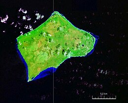 Satellite image of Little Inagua, Bahamas | |
 Little Inagua The location of Little Inagua within the Bahamas | |
| Geography | |
|---|---|
| Location | Atlantic Ocean |
| Coordinates | 21°30′N 73°00′W / 21.500°N 73.000°WCoordinates: 21°30′N 73°00′W / 21.500°N 73.000°W |
| Archipelago | Lucayan Archipelago |
| Area | 50 sq mi (130 km2) |
| Administration | |
Bahamas | |
| Demographics | |
| Population | 0 |
| Additional information | |
| Time zone |
|
| • Summer (DST) |
|
| ISO code | BS-IN |

Little Inagua is a small remote island in the Bahamas. It is the largest uninhabited island in the Caribbean.[1] The island remains in an undisturbed and natural state.[2]
In 2002, it became part of Little Inagua National Park.[1]
See also[]
- Inagua
- List of Islands of The Bahamas
References[]
- ^ Jump up to: a b "Little Inagua National Park". The Bahamas National Trust. Retrieved 4 January 2019.
- ^ "Unprecedented Expansion of National Park System" (PDF). Currents. Bahamas National Trust. June 2002. p. 4. Retrieved 4 January 2019.
| hide Authority control | |
|---|---|
| General |
|
| National libraries | |
This Bahamian location article is a stub. You can help Wikipedia by . |
Categories:
- Uninhabited islands of the Bahamas
- Inagua
- Bahamas geography stubs