Llanrwst
This article uses bare URLs, which may be threatened by link rot. (May 2021) |
| Llanrwst | |
|---|---|
 Pont Fawr, Llanrwst | |
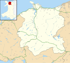 Llanrwst Location within Conwy | |
| Area | 5.24 km2 (2.02 sq mi) |
| Population | 3,323 [1] |
| • Density | 634/km2 (1,640/sq mi) |
| OS grid reference | SH800615 |
| Community |
|
| Principal area |
|
| Ceremonial county |
|
| Country | Wales |
| Sovereign state | United Kingdom |
| Post town | LLANRWST |
| Postcode district | LL26 |
| Dialling code | 01492 |
| Police | North Wales |
| Fire | North Wales |
| Ambulance | Welsh |
| UK Parliament | |
| Senedd Cymru – Welsh Parliament |
|


Llanrwst (i. e. "church or parish of Saint Grwst"; Welsh pronunciation: [ɬanˈruːst]) is a market town and community on the A470 road and the River Conwy, in Conwy County Borough, Wales, and the historic county of Denbighshire. It developed round the wool trade and became known also for the making of harps and clocks.[3] Today, less than a mile from the edge of Snowdonia,[4] its main pursuit is tourism. Notable buildings include almshouses, two 17th-century chapels, and the Parish Church of St Grwst, which holds a stone coffin of Llywelyn the Great. The 2011 census gave the town a population of 3,323.
History[]
The site of the original church dedicated to St Grwst was Cae Llan in Llanrwst (land now occupied by the Seion Methodist Chapel).[5] The current church of St Grwst is on land which was donated in around 1170 by Rhun ap Nefydd Hardd, a member of the royal family of the Kingdom of Gwynedd, specifically to build a new church so dedicated.[6]
Llanrwst developed around the wool trade, and for a long time the price of wool for the whole of Britain was set here.[8] The growth of the village in the 13th century was considerably aided by an edict by Edward I of England (who built Conwy Castle) prohibiting any Welshman from trading within 10 miles (16 km) of the town of Conwy. Llanrwst, located some 13 miles (21 km) from that town, was strategically placed to benefit from this.
In 1276, Llywelyn ap Gruffudd, Prince of Wales, seized the town, declaring the Free Borough of Llanrwst independent from the diocese of Llanelwy. Although this was contested by the bishop, the borough retained its status both through the lifetime of Llywelyn and later through the efforts of Aberconwy Abbey, which ripped down banners related to the bishopric or to Edward I of England. A century later, after the monastery moved to Maenan Abbey,[9] the town had its own coat of arms and flag, the origin of the local motto "Cymru, Lloegr a Llanrwst" (Wales, England and Llanrwst). This motto, a testament to this apparent independence, has now become synonymous with the song of that title by a local band, Y Cyrff. When the Llanrwst Almshouses & Museum Trust closed in 2011,[10] it returned to the community the 12th-century Llanrwst flag, as an emblem central to the town's belief in its independence.[11]
In 1610 Sir John Wynn of Gwydir had the historic Llanrwst Almshouses built to house poor people of the parish. The buildings closed in 1976, but were restored in 1996 with the aid of Heritage Lottery funding, reopening as a museum of local history and a community focal point. The museum held a collection of over a hundred items relating largely to the rural Conwy valley, and a number of items are associated with the renowned Llanrwst Bards of the late 19th century; it closed as a museum in 2011, but reopened in 2013 as the new council chamber.[10][12][13]
Grade I-listed[14] Pont Fawr, a narrow, three-arched stone bridge said to have been designed by Inigo Jones, was built in 1636 by Sir Richard Wynn (son of Sir John Wynn) of Gwydir Castle. The bridge connects the town with Gwydir, a manor house dating from 1492, the 15th-century courthouse known as Tu Hwnt i'r Bont and also with the road from nearby Trefriw.[15][16][17]
In 1947, allegedly, Llanrwst Town Council unsuccessfully sought a seat on the United Nations Security Council, as an independent state within Wales.[11][18] There is no confirmation of this in the United Nations Security Council minutes available online.[1].</ref>
Llanrwst hosted the National Eisteddfod in 1951, 1989 and 2019.[19]
Geography[]
Llanrwst lies between 10 and 50 metres (33 and 160 ft) above sea level on the eastern bank of the River Conwy. The A470 trunk route between North and South Wales runs through the town, where it is joined by the A548 main road from Rhyl, Prestatyn and Chester. To the south-west of the town is the Gwydir Forest. On the hills above is the Moel Maelogan wind farm; the electricity generated by these turbines is sent to the town's sub-station.

Church of St Grwst
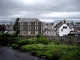
The River Conwy at Llanrwst
Tu Hwnt i'r Bont

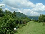
An elevated view of Llanrwst from Gwydir Forest


Governance[]
Llanrwst was the name of the electoral ward to Gwynedd County Council between 1973 and 1996, electing one county councillor.[20]
Llanrwst is now divided into two electoral wards, Gower and Crwst, each electing a councillor to Conwy County Borough Council.[21] In 2017, Plaid Cymru's Aaron Wynne was elected to the Crwst ward on Conwy County Borough Council at 20 years of age, making him Wales's youngest county councillor and Conwy County Borough Council’s youngest ever elected member. The town also elects councillors to Llanrwst Town Council.[22]
Demography[]
In the 2011 census the town population was put at 3,323,[1] 61 per cent being Welsh speakers.[23] At one time Llanrwst was the Wales's eighth largest town, with a higher population than Cardiff.[25][26] The change in the town population in the 19th and 20th centuries appears in the chart below.

Transport[]
Llanrwst is served by two railway stations, Llanrwst and North Llanrwst, on the Conwy Valley Line (which once terminated here, before being extended to Betws-y-Coed in 1867 and Blaenau Ffestiniog in 1879). It was originally envisaged that the railway would pass closer to the river (on the site of today's Central Garage), and the Victoria Hotel was built opposite the bridge in anticipation of this. Had the railway line been built on the west bank of the River Conwy, as originally planned (to serve the inland port of Trefriw located across the river from Llanrwst), it is unlikely that Llanrwst would have achieved its present status.
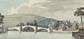
18th century water colour of Llanrwst Bridge

Plan of bridge, 1753

Engraving, 1790

Early 19th century
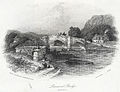
Engraving, 1842


Education[]
Ysgol Dyffryn Conwy, previously Llanrwst Grammar School, is a bilingual secondary school with about 790 pupils. According to the latest inspection report by Estyn, the school has a GCSE pass rate of 71 per cent (based on five GCSEs, grades A–C). This puts the school in equal 24th place, just outside the top 10 per cent of secondary schools in Wales. It is also the second best-performing secondary school in Conwy, behind Eirias High School in Colwyn Bay.
There is a Christian-based youth club in Seion Chapel called Clwb Cyfeillion.
Sport[]
Llanrwst is home to Llanrwst United FC, which has two senior teams. The first plays in the Welsh Alliance League and the reserve team in Clwyd League Division 2. The club also has a junior section: Llanrwst United Juniors has eight teams and plays in the Aberconwy and Colwyn League. plays in the North Wales Premier Cricket League. Since 2012, there has been an annual half marathon around the town.[27]
Notable people[]
In birth order:
- Evan Owen Allen (1805–1852), Welsh-language journalist and poet, was born at Pant-y-llin, near Llanrwst.
- Peter Thomas, Baron Thomas of Gwydir (1920-2008), Welsh politician, born in Llanrwst. Former Secretary of State for Wales
- Mark Roberts (born 1967) of Catatonia and its predecessor Y Cyrff, known for the song Cymru, Lloegr a Llanrwst
- Kai Owen (born 1975), actor notable as Rhys Williams in Torchwood
- Glyn Wise (born 1988), runner-up as a Big Brother 7 (UK) contestant on television in 2006, attended Ysgol Dyffryn Conwy.
- Alex Frew (born 1988), graphic designer, created the Wales brand and Transport for Wales brand identities.
- Erin Mai (born 2005 or 2006), Wales's representative at the 2019 edition of the Junior Eurovision Song Contest with "Calon yn Curo (Heart Beating)" after victory at the S4C show Chwilio am Seren
See also[]
References[]
- ^ Jump up to: a b "Area: Llanrwst (Parish), Key Figures for 2011 Census: Key Statistics". Neighbourhood Statistics. Office for National Statistics. Retrieved 15 May 2014.
- ^ https://cyngor.wixsite.com/cyngorllanrwst/home
- ^ "snowdoniaantiques.co.uk - Snowdonia Antiques. North Wales Fine Antique Furniture and Clock Specialists". snowdoniaantiques.co.uk.
- ^ Snowdonia National Park Authority. "Location Map". Archived from the original on 23 October 2014.
- ^ "History of Llanrwst: Saint Grwst the Confessor". Retrieved 18 April 2015.
- ^ "History of Llanrwst: Foundation of the Modern Church".
- ^ Lewis, Samuel (1840). A Topographical Dictionary of Wales Vol 1. London: S Lewis. ISBN 9780598739971.
- ^ "Llanrwst is the principal mart for this article, and is attended by the English buyers: the price obtained for the wool at this fair is usually the standard for the year."[7]
- ^ "BBC – Gogledd Orllewin – hanes".
- ^ Jump up to: a b "Llanrwst Almshouse Museum rent rise blamed for closure". BBC Wales. Retrieved 18 April 2015.
- ^ Jump up to: a b Talk of the town BBC News, 28 April 2006.
- ^ "Celebrations as town council re-open Llanrwst Almshouses Museum". Daily Post.
- ^ "Llanrwst Almshouses re-opens and is taken on by village council". Daily Post. Retrieved 18 April 2015.
- ^ Cadw. "Pont Fawr (Grade I) (16951)". National Historic Assets of Wales. Retrieved 14 July 2019.
- ^ "Tu Hwnt Ir Bont Tearooms - Llanrwst Conwy North Wales". www.tuhwntirbont.co.uk.
- ^ "Tu Hwnt ir Bont in Wales". Wales Directory.
- ^ "Llanrwst" (PDF). Conservation Area Appraisal – Conwy County Borough Council. Conwy County Borough Council. Archived from the original (PDF) on 18 April 2015.
- ^ Breverton, Terry (2012). Owain Glyndwr: The Story of the Last Prince of Wales. Amberley Publishing Limited. ISBN 978-1445608761.
- ^ "National Eisteddfod". National Eisteddfod. Retrieved 15 March 2018.
- ^ "Gwynedd Council Election Results 1995-2012" (PDF). The Elections Centre (Plymouth University). Retrieved 23 April 2019.
- ^ Local_Election_Results_County_Conwy_and_Denbighshire/ "Local Election Results (County): Conwy and Denbighshire" Check
|url=value (help). North Wales Pioneer. 5 May 2017. Retrieved 23 March 2018. - ^ "Llanrwst Town Council, Llanrwst.net. Retrieved 23 March 2018". Archived from the original on 22 February 2014. Retrieved 23 March 2018.
- ^ "Archived copy" (PDF). Archived from the original (PDF) on 5 March 2014. Retrieved 5 March 2014.CS1 maint: archived copy as title (link)
- ^ "Cardiff Glamorgan". Vision of Britain.
- ^ "In 1801 the pop. [of Cardiff] was only 1018; in 1841 it was 10,077..."[24]
- ^ "Llanrwst CP/AP". Vision of Britain.
- ^ "Snowdonia Half Marathon – Run Wales". www.runwales.com.
External links[]
| Wikimedia Commons has media related to Llanrwst. |
| Wikivoyage has a travel guide for Llanrwst. |
- A Vision of Britain Through Time
- British Listed Buildings
- Clwyd Churches
- Genuki
- Geograph
- Office for National Statistics

| show Authority control |
|---|
- Llanrwst
- Towns in Conwy County Borough
- Former electoral wards of Gwynedd