Loch Long
This article needs additional citations for verification. (February 2012) |
| Loch Long | |
|---|---|
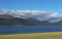
 Looking down Loch Long from the torpedo testing facility. The houses to the left are at Ardmay. | |
 Loch Long | |
| Location | Cowal, Argyll and Bute, Scotland. |
| Coordinates | 56°02′04″N 4°53′08″W / 56.034395°N 4.8855839°WCoordinates: 56°02′04″N 4°53′08″W / 56.034395°N 4.8855839°W, grid reference NS2031486146 |
| Type | Sea Loch |
| Basin countries | Scotland, United Kingdom |
| Frozen | No |

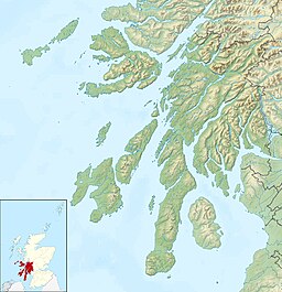
Loch Long is a body of water in Argyll and Bute, Scotland. The Sea Loch extends from the Firth of Clyde at its southwestern end. It measures approximately 20 miles (32 km) in length, with a width of between 1 and 2 miles (1.6 and 3.2 km). The loch also has an arm, Loch Goil, on its western side.
Loch Long forms part of the coast of the Cowal peninsula and forms the entire western coastline of the Rosneath Peninsula.
Loch Long was historically the boundary between Argyll and Dunbartonshire; however, in 1996 boundary redrawing meant that it moved wholly within the council area of Argyll and Bute.
The steamboat Chancellor used to traverse the loch, departing Dunoon at 11 A.M. and returning about five hours later.[1]
Villages on Loch Long[]
Villages on the loch include Arrochar at its head and Cove on the east shore near its foot.
Fisheries[]
This section does not cite any sources. (December 2020) |
Several Scottish sea fishing records are attributed to the loch:[clarification needed]
| Species | Weight | Angler / Date |
|---|---|---|
| Argentine | 00-05-03 | I. Miller, 1978 (Boat) |
| Herring | 01-02-00 | R. C. Scott, 1974 (Boat) |
| Rockling, Shore | 00-14-08 | A. Glen, 1982 (Shore) |
Sport[]
The Ardentinny Outdoor Education Centre on the western shore uses the loch for watersports.
It is now a popular area for diving on the numerous wrecks that scatter the loch.
Finnart Oil Terminal[]
The Finnart Oil Terminal is located on the eastern shore of the loch, linked to the Grangemouth Refinery via a 58-mile-long (93 km) pipeline.[2]
[]

The eastern shore is also the location of the Royal Navy's Coulport Armament depot, part of HMNB Clyde, and the Glen Mallan jetty, linked to Glen Douglas defence munitions depot.
A testing range for torpedoes was established on the loch in 1912, in connection with the Clyde Torpedo Factory in Greenock.[3] It operated through both World Wars, closing in 1986.[4][5] The loch contains numerous wrecks.
References[]
- ^ Colegate's Guide to Dunoon, Kirn, and Hunter's Quay (Second edition) - John Colegate (1868), page 53
- ^ Fullarton, Donald (29 July 2011). "Americans built oil terminal". Helensburgh Heritage. Retrieved 23 May 2013.
- ^ Brassey, Thomas, Viscount Hythe, ed. (1913). "British Navy". The Naval Annual. Portsmouth: J. Griffin and Co. p. 23.
- ^ Makeenko, Viktoriia. "Loch Long Torpedo Range". Abandoned Spaces. Timera Media. Retrieved 24 February 2021.
- ^ Nicol, James. "Home on the Range - The Passing of an Era". Arrochar, Tarbet and Ardlui Heritage. Retrieved 24 February 2021.
External links[]
| Wikimedia Commons has media related to Loch Long, Argyll and Bute. |
- Map sources for Loch Long
- Gaelic place names of Scotland
- Map showing Loch Long, circa 1600, National Library of Scotland
- Video footage of the old Arrochar steamer pier
| show Recreational dive sites |
|---|
| Authority control |
|
|---|
- Sea lochs of Scotland
- Lochs of Argyll and Bute
- Firth of Clyde
- Cowal
- Wreck diving sites in Scotland