Lockwood, Nevada
Lockwood, Nevada | |
|---|---|
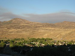 Lockwood, June 2007 | |
 Lockwood, Nevada Location within the state of Nevada | |
| Coordinates: 39°30′26″N 119°38′48″W / 39.50722°N 119.64667°WCoordinates: 39°30′26″N 119°38′48″W / 39.50722°N 119.64667°W[1] | |
| Country | United States |
| State | Nevada |
| County | Storey |
| Elevation | 4,360 ft (1,329 m) |
| Time zone | UTC-8 (Pacific (PST)) |
| • Summer (DST) | UTC-7 (PDT) |
| ZIP codes | 89464 |
| Area code(s) | 775 |
| GNIS feature ID | 856069 |


Lockwood is an unincorporated community on the northern edge of Storey County, Nevada, United States,[1] about 10 miles (16 km) east of Reno and Sparks. Lockwood is part of the Reno-Sparks Metropolitan Area.[2]
Description[]
The community of Lockwood lies between the Truckee River on the north and the Virginia Range on the south. It is connected to the Reno-Sparks area by a bridge over the Truckee River on Canyon Way that connects the area with an interchange (Exit 22) on Interstate 80 (across the Washoe County line).[3]
In addition to outlying residences, Lockwood is home to two communities, the Rainbowbend subdivision and the Lockwood Community Corporation mobile home park.[4] The community also boasts its own parks, elementary school, community centers, and businesses. Lockwood is served by the Storey County Sheriff's Office and Storey County Fire Department, each having a substation in the community. Community resources include a clothing closet and food pantry.[citation needed]
Education[]
Lockwood's elementary school; Hillside Elementary, serves students residing in the Lockwood area and attending Kindergarten through 5th grade. Class sizes are on average about 1/3 those of the neighboring districts. Older students attend either Virginia City Middle School (grades 6-8) or (grades 9-12), both located in Virginia City.[5]
References[]
- ^ Jump up to: a b c U.S. Geological Survey Geographic Names Information System: Lockwood
- ^ "OMB Bulletin No. 20-01: Revised Delineations of Metropolitan Statistical Areas, Micropolitan Statistical Areas, and Combined Statistical Areas, and Guidance on Uses of the Delineations of These Areas" (PDF). Whitehouse.gov. United States Office of Management and Budgetformat=PDF. 6 Mar 2020. p. 64. Retrieved 4 May 2020.
- ^ Google (4 May 2020). "Lockwood, Nevada 89434" (Map). Google Maps. Google. Retrieved 4 May 2020.
- ^ Damon, Anjeanette (7 Nov 2016). "Water problems plague Lockwood, open rift in the small community". Reno Gazette-Journal. Reno, Nevada: Gannett Co., Inc. Retrieved 4 May 2016.
- ^ "Storey County School District: Schools". storey.k12.nv.us. . Retrieved 4 May 2020.
External links[]
| Wikimedia Commons has media related to Lockwood, Nevada. |
| hide Municipalities and communities of Storey County, Nevada, United States | ||
|---|---|---|
| CDP | ||
| Unincorporated community | ||
| Footnotes | ‡This populated place also has portions in adjacent county or counties. | |
| ||
This Storey County, Nevada state location article is a stub. You can help Wikipedia by . |
- Unincorporated communities in Nevada
- Unincorporated communities in Storey County, Nevada
- Reno, NV Metropolitan Statistical Area
- Nevada geography stubs