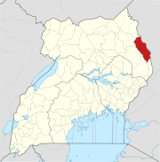
Lokitanyala, Uganda
Lokitanyala, Uganda | |
|---|---|
 Lokitanyala, Uganda Location in Uganda | |
| Coordinates: 02°21′53″N 34°55′13″E / 2.36472°N 34.92028°E | |
| Country | |
| Region | Northern Region |
| Sub-region | Karamoja sub-region |
| District | Moroto District |
| • Summer (DST) | |
Lokitanyala, Uganda is a settlement in the Moroto District in the Northern Region of Uganda. It lies directly across from Lokitanyala, Kenya, separated by the international border between Uganda and Kenya.
Location[]
The settlement is in the Karamoja sub-region and is approximately 40 kilometres (25 mi), by road, southeast of Moroto, the nearest large town and the location of the district headquarters. The coordinates of Lokitanyala are 2°21'53.0"N, 34°55'13.0"E (Latitude:2.364728; Longitude:34.920284).[1]
Overview[]
The town is one of the end points of the 208 kilometres (129 mi) Soroti–Katakwi–Moroto–Lokitanyala Road.[2] The town is a border crossing between Uganda and neighboring Kenya.
See also[]
References[]
- ^ Google (19 January 2016). "Location of Lokitanyala, Moroto District, Uganda" (Map). Google Maps. Google. Retrieved 19 January 2016.
- ^ UNRA (19 January 2016). "Upcoming Projects: New Roads for Upgrade to Tarmac". Kampala: Uganda National Roads Authority (UNRA). Archived from the original on 20 January 2016. Retrieved 19 January 2016.
External links[]
Categories:
- Populated places in Northern Region, Uganda
- Moroto District
- Kenya–Uganda border crossings

