Districts of Uganda

From Wikipedia, the free encyclopedia

As of July 2020, Uganda is divided into 135 districts and the capital city of Kampala, which are grouped into four administrative regions.[1][2]

Since 2005, the Ugandan government has been in the process of dividing districts into smaller units. This decentralization is intended to prevent resources from being distributed primarily to chief towns and leaving the remainder of each district neglected.[3]

Each district is further divided into counties and municipalities,[4] and each county is further divided into sub-counties. The head elected official in a district is the chairperson of the Local Council five (usually written with a Roman numeral V).

Below are population figures from the 2014 census.[5]
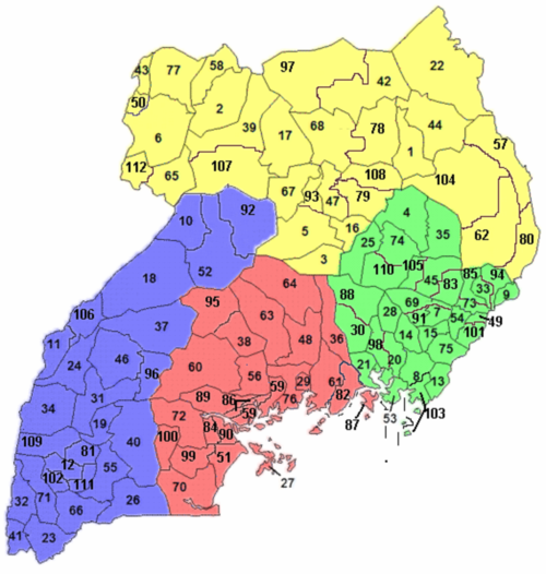
A clickable map of Kampala and the 111 districts of Uganda as of 2010.
Buikwe DistrictBukomansimbi DistrictButambala DistrictBuvuma DistrictGomba DistrictKalangala DistrictKalungu DistrictKampala DistrictKayunga DistrictKiboga DistrictKyankwanzi DistrictLuweero DistrictLwengo DistrictLyantonde DistrictMasaka DistrictMityana DistrictMpigi DistrictMubende DistrictMukono DistrictNakaseke DistrictNakasongola DistrictRakai DistrictSembabule DistrictWakiso DistrictMpigi DistrictBusia DistrictBulambuli DistrictBukwa DistrictBukedea DistrictBugiri DistrictBududa DistrictBudaka DistrictAmuria DistrictButaleja DistrictBuyende DistrictIganga DistrictJinja DistrictKaberamaido DistrictKaliro DistrictKamuli DistrictKapchorwa DistrictKatakwi DistrictKibuku DistrictKumi DistrictKween DistrictLuuka DistrictManafwa DistrictMayuge DistrictMbale DistrictNamayingo DistrictNamutumba DistrictNgora DistrictPallisa DistrictSerere DistrictSironko DistrictSoroti DistrictTororo DistrictAbim DistrictAdjumani DistrictAgago DistrictAlebtong DistrictAmolatar DistrictAmudat DistrictAmuru DistrictApac DistrictArua DistrictDokolo DistrictGulu DistrictKaabong DistrictKitgum DistrictKoboko DistrictKole DistrictKotido DistrictLamwo DistrictLira DistrictMaracha DistrictMoroto DistrictMoyo DistrictNakapiripirit DistrictNapak DistrictNebbi DistrictNwoya DistrictOtuke DistrictOyam DistrictPader DistrictYumbe DistrictZombo DistrictBuhweju DistrictBuliisa DistrictBundibugyo DistrictBushenyi DistrictHoima DistrictIbanda DistrictIsingiro DistrictKabale DistrictKabarole DistrictKamwenge DistrictKanungu DistrictKasese DistrictKibaale DistrictKiruhura DistrictKiryandongo DistrictKisoro DistrictKyegegwa DistrictKyenjojo DistrictMasindi DistrictMbarara DistrictMitooma DistrictNtoroko DistrictNtungamo DistrictRubirizi DistrictRukungiri DistrictSheema DistrictA clickable map of Kampala and the 111 districts of Uganda as of 2010.
About this image


Central Region
(red)
Map District pop.
82 Buikwe 422,771
84 Bukomansimbi 151,413
86 Butambala 100,840
87 Buvuma 89,890
89 Gomba 159,922
27 Kalangala 54,293
90 Kalungu 183,232
29 Kampala 1,507,080
36 Kayunga 368,062
38 Kiboga 148,218
95 Kyankwanzi 214,693
48 Luweero 456,958
99 Lwengo 274,953
100 Lyantonde 93,753
51 Masaka 297,004
56 Mityana 328,964
59 Mpigi 250,548
60 Mubende 684,337
61 Mukono 596,804
63 Nakaseke 197,369
64 Nakasongola 181,799
70 Rakai 516,309
72 Sembabule 252,597
76 Wakiso 1,997,418
Eastern Region
(green)
Map District pop.
4 Amuria 270,928
7 Budaka 207,597
49 Bududa 210,173
8 Bugiri 382,913
83 Bukedea 203,600
9 Bukwa 89,356
85 Bulambuli 174,508
13 Busia 323,662
15 Butaleja 224,153
88 Buyende 323,067
20 Iganga 504,197
21 Jinja 471,242
25 Kaberamaido 215,026
28 Kaliro 236,199
30 Kamuli 486,319
33 Kapchorwa 105,186
35 Katakwi 166,231
91 Kibuku 202,033
45 Kumi 239,268
94 Kween 93,667
98 Luuka 238,020
101 Manafwa 353,825
53 Mayuge 473,239
54 Mbale 488,960
103 Namayingo 215,442
14 Namutumba 252,562
105 Ngora 141,919
69 Pallisa 386,890
110 Serere 285,903
73 Sironko 242,422
74 Soroti 296,833
75 Tororo 517,082
Northern Region
(yellow)
Map District pop.
1 Abim 107,966
2 Adjumani 225,251
78 Agago 227,792
79 Alebtong 227,541
3 Amolatar 147,166
80 Amudat 105,767
39 Amuru 186,696
5 Apac 368,626
6 Arua 782,077
16 Dokolo 183,093
17 Gulu 436,345
22 Kaabong 167,879
42 Kitgum 204,048
43 Koboko 206,495
93 Kole 239,327
44 Kotido 181,050
97 Lamwo 134,379
47 Lira 408,043
50 Maracha 186,134
57 Moroto 103,432
58 Moyo 139,012
62 Nakapiripirit 156,690
104 Napak 142,224
65 Nebbi 396,794
107 Nwoya 133,506
108 Otuke 104,254
67 Oyam 383,644
68 Pader 178,004
77 Yumbe 484,822
112 Zombo 240,082
Western Region
(blue)
Map District pop.
81 Buhweju 120,720
10 Buliisa 113,161
11 Bundibugyo 224,387
12 Bushenyi 234,440
18 Hoima 572,986
19 Ibanda 249,625
26 Isingiro 486,360
23 Kabale 528,231
24 Kabarole 469,236
31 Kamwenge 414,454
32 Kanungu 252,144
34 Kasese 694,992
37 Kibaale 785,088
40 Kiruhura 328,077
92 Kiryandongo 266,197
41 Kisoro 281,705
96 Kyegegwa 281,637
46 Kyenjojo 422,204
52 Masindi 291,113
55 Mbarara 472,629
102 Mitooma 183,444
106 Ntoroko 67,005
66 Ntungamo 483,841
109 Rubirizi 129,149
71 Rukungiri 314,694
111 Sheema 207,343


Districts created since 2015[]

In September 2015, the Parliament of Uganda created 23 new districts, to be phased in over the next four years.[6]

Date effective New district Parent district
1 July 2016 Kagadi Kibaale
Kakumiro Kibaale
Omoro Gulu
Rubanda Kabale
1 July 2017 Namisindwa Manafwa
Pakwach Nebbi
Butebo Pallisa
Rukiga Kabale
Kyotera Rakai
Bunyangabu Kabarole
1 July 2018 Nabilatuk Nakapiripirit
Bugweri Iganga
Kasanda Mubende
Kwania Apac
Kapelebyong Amuria
Kikuube Hoima
1 July 2019 Obongi Moyo
Kazo Kiruhura
Rwampara Mbarara
Kitagwenda Kamwenge
Madi-Okollo Arua
Karenga Kaabong
Kalaki Kaberamaido

In May 2020, Parliament approved the creation of Terego District, which went into effect on 1 July 2020.[7]

Ugandan districts as of 2006, when there were 77 districts.

See also[]

References[]

  1. ^ "UG – Uganda". ISO 3166. ISO. 23 November 2017. Retrieved 1 December 2017.
  2. ^ "Ministry of Local Government Fact Sheet" (PDF). MOLG. 1 July 2017. Retrieved 1 December 2017.
  3. ^ Ocwich, Denis (7 August 2005). "Can Uganda's economy support more districts?". New Vision.
  4. ^ "Uganda Districts". statoids.com.
  5. ^ "National Population and Housing Census 2014 Main Report" (PDF). Uganda Bureau of Statistics. Archived from the original (PDF) on 12 October 2017. Retrieved 2 January 2017.
  6. ^ Nakatudde, Olive (4 September 2015). "Parliament Approves 23 New Districts". Uganda Radio Network. Retrieved 25 December 2020.
  7. ^ "Parliament approves creation of Terego district". The Independent. 6 May 2020. Retrieved 25 December 2020.

External links[]

Retrieved from ""