From Wikipedia, the free encyclopedia
Districts of Botswana Category Unitary State Location Republic of Botswana Number 17 Districts Populations 3,598 (Sowa ) – 576,064 (Central District ) Areas 17 km2 (6.6 sq mi) (Orapa ) – 142,076 km2 (54,856 sq mi) (Central District ) Government Subdivisions
Botswana is divided into 17 administrative districts : 10 rural districts and 7 urban districts. These are administered by 16 local authorities (district councils, city councils or town councils).[1] [2]
District
Population
Area (km2 )
Density (/km2 )
Gaborone City231,592
169
Francistown City98,961
79
Lobatse Town29,007
42
Selebi-Phikwe Town49,411
50
Jwaneng Town18,008
100
Orapa Town9,531
17
Sowa Township3,598
159
Southern District 197,767
28,470
South-East District 85,014
1,780
Kweneng District 304,549
31,100
Kgatleng District 91,660
7,960
Central District 576,064
142,076
North-East District 60,264
5,120
Ngamiland District 152,284
109,130
Chobe District 23,347
20,800
Ghanzi District 43,095
117,910
Kgalagadi District 50,752
105,200
Total[note 1]
2,024,904
570,162
^ Census report has total area as 581730 km2 .
See also [ ] References [ ]
Categories :
Districts of Botswana Subdivisions of Botswana Lists of administrative divisions Administrative divisions in Africa First-level administrative divisions by country Botswana geography-related lists Hidden categories:
Pages with non-numeric formatnum arguments Webarchive template wayback links
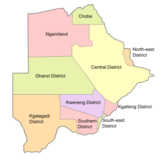 Districts of Botswana. The seven urban districts are not shown.