Long Tanid
Long Tanid | |
|---|---|
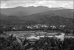 Rice fields in Long Tanid | |
 Long Tanid | |
| Coordinates: 4°13′00″N 115°35′00″E / 4.21667°N 115.58333°ECoordinates: 4°13′00″N 115°35′00″E / 4.21667°N 115.58333°E | |
| Country | |
| State | |
| Administrative Division | Lawas |
| Elevation | 1,231 m (4,039 ft) |

Long Tanid (also known as Long Tanla) is a settlement in the Lawas division of Sarawak, Malaysia.[1][2] It is about 3 hours drive from Lawas just before entering Ba'kelalan.[3]
Geography[]
Neighbouring settlements include:
- 2.6 kilometres (1.6 mi) northeast
- 2.6 kilometres (1.6 mi) southwest
- Long Semado 3.7 kilometres (2.3 mi) north
- Long Karabangan 4.1 kilometres (2.5 mi) southwest
- Long Kinoman 6.7 kilometres (4.2 mi) northeast
- Long Lapukan 7.9 kilometres (4.9 mi) northwest
- Punang Terusan 8.3 kilometres (5.2 mi) northeast
- Long Lopeng 13.3 kilometres (8.3 mi) northwest
- Long Ugong 15.3 kilometres (9.5 mi) south
- 18.9 kilometres (11.7 mi) south
References[]
- ^ M. Mohizah, S. Julia and W. K. Soh (2006). A Sarawak Gazetteer (PDF). Kuala Lumpur: Sarawak Forestry Department Malaysia and Forest Research Institute Malaysia. ISBN 983-2181-86-0. OCLC 85818866. Archived from the original (PDF) on 2011-07-22. Retrieved 2011-01-01.
- ^ "Long Tanid, Malaysia". Geonames. 2010-08-09. Retrieved 2010-12-27.
- ^ Jonna, Yap (21 September 2014). "Hidden gems of Long Tanid". The Borneo Post. Archived from the original on 3 April 2016. Retrieved 24 April 2018.
Categories:
- Populated places in Sarawak