Lorentz River
| The Lorentz River Undir, North River | |
|---|---|
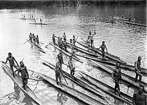 The Lorenz during the third South New Guinea expedition (1912-13) | |
 Location in Papua | |
| Location | |
| Country | Indonesia |
| State | Province of Papua |
| Physical characteristics | |
| Source | Southeast of the Puncak Trikora in the Jayawijaya Mountains |
| • location | Western New Guinea, Indonesia |
| • coordinates | 4°15′S 138°40′E / 4.250°S 138.667°E |
| Length | 380 km (240 mi) |
| Discharge | |
| • location | Arafura Sea |
| Discharge | |
| • location | Indonesia |


The Lorentz River (also Unir or Undir in Indonesian, or Noordrivier in Dutch) is located in the Indonesian province of Papua in Western New Guinea, about 3500 km northeast of the Indonesian capital Jakarta.[1] It originates in the central east-west mountain range of New Guinea, and flows southwards into the Arafura Sea at Flamingo Bay. During the first two Dutch expeditions to Southern New Guinea (1907–10) it was called Northern River. In 1910 it was renamed after the Dutch explorer Hendrikus Albertus Lorentz. After it became part of Indonesia, it was renamed to Unir, as in the language of the local Asmat people, while the Lorentz name is still in use.
History[]
At the beginning of the 20th century the navigable part of the river played an important role in the exploration of Dutch New Guinea in western New Guinea. Three large Dutch expeditions led from the mouth upstream to the central snow-capped mountains, which were still unexplored. The aim of the expeditions was to cover the Wilhelmina summit (now called Puncak Trikora ) covered by "eternal snow" . The first of the three South New Guinea expeditions failed before the mountain could be reached. The second expedition reached the snow-capped foot of Wilhelmina, but it was only during the third expedition that the mountain could be conquered on 21 February 1913.
Geography[]
The river flows in the southwest area of Papua with predominantly tropical rainforest climate (designated as Af in the Köppen-Geiger climate classification).[2] The annual average temperature in the area is 21 °C. The warmest month is October, when the average temperature is around 23 °C, and the coldest is July, at 20 °C.[3] The average annual rainfall is 5547 mm. The wettest month is May, with an average of 594 mm rainfall, and the driest is July, with 384 mm rainfall.[4]
See also[]
References[]
- ^ Sungai Lorentz at Geonames.org (cc-by); Last updated 2013-06-04; Database dump downloaded 2015-11-27
- ^ Peel, M C; Finlayson, B L; McMahon, T A (2007). "Updated world map of the Köppen-Geiger climate classification". Hydrology and Earth System Sciences. 11 (5): 1633–1644. Bibcode:2007HESS...11.1633P. doi:10.5194/hess-11-1633-2007. Retrieved 30 January 2016.
- ^ "NASA Earth Observations Data Set Index". NASA. 30 January 2016.
- ^ "NASA Earth Observations: Rainfall (1 month - TRMM)". NASA/Tropical Rainfall Monitoring Mission. 30 January 2016.
External links[]
- Map and pictures of Lorentz River from The Papua Insects Foundation.
Coordinates: 5°32′32″S 138°02′36″E / 5.54222°S 138.04333°E
- Rivers of Papua (province)
- Rivers of Indonesia