Papua (province)
Papua | |
|---|---|
Province of Indonesia | |
 Flag  Coat of arms | |
| Nickname(s): Bumi Cenderawasih (Indonesian) Land of Paradisaea | |
| Motto(s): कार्य स्वाध्याय Karya Swadaya (Sanskrit) Work with one's own might | |
 Location of Papua in Indonesia | |
| Coordinates (Jayapura): 2°32′S 140°43′E / 2.533°S 140.717°ECoordinates: 2°32′S 140°43′E / 2.533°S 140.717°E | |
| Established | 1 May 1963 |
| Capital and largest city | Jayapura |
| Divisions | 29 regencies and cities, 576 districts, 5555 villages (desa and kelurahan) |
| Government | |
| • Body | Papuan Provincial Government |
| • Governor | (Acting) |
| • Vice Governor | vacant |
| Area | |
| • Total | 312,224.37 km2 (120,550.50 sq mi) |
| Area rank | 1st in Indonesia |
| Highest elevation (Puncak Jaya) | 4,884 m (16,024 ft) |
| • Rank | 1st in Indonesia |
| Lowest elevation | 4 m (13 ft) |
| Population (2020 Census)[1] | |
| • Total | 4,303,707 |
| • Rank | 21st in Indonesia |
| • Density | 14/km2 (36/sq mi) |
| Health Ministry 2014 Estimate | |
| Demographics | |
| • Ethnic groups | Papuans (including Asmat, Auwye/Mee, Biak, Dani, Damal, Dauwa, Hupla, Kamoro, Ketengban, Lani, Marind-Anim, Moni, Ngalik/Yali, Ngalum, Sentani, Serui/Yapen, Waropen, Yaghay, etc), Ambonese, Bugis, Butonese, Evav/Kei, Javanese, Makassar, Minahasa, Toraja, etc [2] |
| • Religion | Christianity (84.42%) Islam (15.29%) Hinduism (0.08%) Buddhism (0.05%) Other (0.016%) [3] |
| • Languages | Indonesian (official) Papuan Malay (lingua franca) 269 indigenous Papuan languages, Austronesian languages[4] |
| Time zone | UTC+9 (Indonesia Eastern Time) |
| ISO 3166 code | ID-PA |
| Vehicle registration | PA |
| HDI | |
| HDI rank | 34th in Indonesia (2020) |
| GRP Nominal | |
| GDP PPP (2019) | |
| GDP rank | 17th in Indonesia (2019) |
| Nominal per capita | US$3,970 (2019)[5] |
| PPP per capita | US$11,513 (2019)[5] |
| Per capita rank | 11th in Indonesia (2019) |
| Website | papua |

Papua, formerly Irian Jaya, is the largest and easternmost province of Indonesia, comprising most of Western New Guinea.[6] The province is located on the island of New Guinea. It is bordered by the state of Papua New Guinea to the east, the province of West Papua to the west, the Pacific Ocean to the north, and the Arafura Sea to the south. The province also shares maritime boundaries with Palau to the north. The province is divided into twenty-eight regencies and one city. Its capital and largest city is Jayapura. The province has a large potential in natural resources, such as gold, nickel, petroleum, etc.[7] Puncak Jaya is the province's highest mountain and the highest point in Indonesia. Papua, along with West Papua, has a higher degree of autonomy level compared to other Indonesian provinces.[8]
The island of New Guinea has been populated for tens of thousands of years. European traders began frequenting the region around the late 16th century due to spice trade. In the end, the Dutch Empire emerged as the dominant leader in the spice war, annexing the western part of New Guinea into the colony of Dutch East Indies. The Dutch remained in New Guinea until 1962, even though other parts of the former colony has declared independence as the Republic of Indonesia in 1945.[9] Following negotiations and conflicts with the Indonesian government, the Dutch transferred Western New Guinea to a United Nations Temporary Executive Authority (UNTEA), which was again transferred to Indonesia after the controversial Act of Free Choice.[10] The province was formerly called Irian Jaya and comprised the entire Western New Guinea until the inauguration of the province of West Papua (then West Irian Jaya) in 2001. In 2002, Papua adopted its current name and was granted a special autonomous status under Indonesian legislation.
The province of Papua remains one of the least developed provinces in Indonesia. As of 2020, Papua has a GDP per capita of Rp 56,141 (US$ 3,970), ranking 11th place among all Indonesian provinces.[11] However, Papua only has a Human Development Index of 0.604, the lowest among all Indonesian provinces.[12] The harsh New Guinean terrain and climate is one of the main reasons why infrastructure in Papua is considered to be the most challenging to be developed among other Indonesian regions.[13]
The 2020 Census revealed a population of 4,303,707, of which the majority of are Christians.[14][15] The interior is predominantly populated by ethnic Papuans while coastal towns are inhabited by descendants of intermarriages between Papuans, Melanesians and Austronesians, including the Indonesian ethnic groups. Migrants from the rest of Indonesia also tend to inhabit the coastal regions.[16] The province is also home to some uncontacted peoples.[17]
History[]
Etymology[]
Dutch East India Company 1640s–1799
Dutch East Indies 1800–1942; 1944–1949
Empire of Japan 1942–1944
Dutch New Guinea 1949–1962
UNTEA 1962–1963
Republic of Indonesia 1963–present
There are several theories regarding the origin of the word Papua. One theory is that the name comes from the word 'Papa-Ua', which is named by the Tidore Sultanate, which in the Tidore language means "not joining" or "not being united", which means that on this island there is no king who rules.[18] Before the age of colonization, the Tidore Sultanate exercised suzerainty over some parts of the Bird's Head Peninsula in what is now the province of West Papua, which plays an important historical role in binding the archipelagic civilizations of Indonesia to the Papuan world.[19] Another theory is that the word Papua comes from the Old Malay word 'papuwah', which means 'curly hair'.[20] In the records of 16th century Portuguese and Spanish sailors, the word 'Papua' is the designation for the inhabitants who inhabit the Raja Ampat Islands and the coastal parts of the Bird's Head Peninsula.[21]
The former name of the province, Irian Jaya, is taken from the Biak language of Biak Island, and means "to rise", or "rising spirit". Irian is the name used in the Biak language and other languages such as Serui, Merauke and Waropen.[22] The name was promoted in 1945 by Marcus Kaisiepo, brother of the future governor Frans Kaisiepo.[23] Some sources stated that the word Irian comes from the Indonesian acronym 'Ikut Republik Indonesia Anti Nederland' (Join the Republic of Indonesia oppose the Netherlands).[24] The name was used throughout the Suharto administration, until it was changed to Papua during the administration of President Abdurrahman Wahid.[25][26]
The Dutch, who arrived later under Jacob Le Maire and Willem Schouten, called it Schouten island. They later used this name only to refer to islands off the north coast of Papua proper, the Schouten Islands or Biak Island. When the Dutch colonized this island as part of the Dutch East Indies, they called it Nieuw Guinea.[22]
Speakers align themselves with a political orientation when choosing a name for the western half of the island of New Guinea.[27] The official name of the region is "Papua" according to International Organization for Standardization (ISO).[28] Independence activists refer to the region as "West Papua," while Indonesian officials have also used "West Papua" to name the westernmost province of the region since 2007.[29] Historically, the region has had the official names of Netherlands New Guinea (1895–1962), West New Guinea or West Irian (1962–73), Irian Jaya (1973–2002), and Papua (2002–present).[30]
Pre-colonial era[]
Papuan habitation of the region is estimated to have begun between 42,000 and 48,000 years ago.[31] Research indicates that the highlands were an early and independent center of agriculture, and show that agriculture developed gradually over several thousands of years; the banana has been cultivated in this region for at least 7,000 years.[32] Austronesian peoples migrating through Maritime Southeast Asia settled in the area at least 3,000 years ago, and populated especially in Cenderawasih Bay. Diverse cultures and languages have developed in the island due to geographical isolation; there are over 300 languages and two hundred additional dialects in the region (see Papuan languages, Austronesian languages, Central–Eastern Malayo-Polynesian languages).
Ghau Yu Kuan, a Chinese merchant, came to Papua around the latter half of 500 AD and referred to it as Tungki, the area where they obtained spices. Meanwhile, in the latter half of 600 AD, the Sumatra-based empire of Srivijaya (7th century–13th century) referred to the island as Janggi. The empire engaged in trade relations with western New Guinea, initially taking items like sandalwood and birds-of-paradise in tribute to China, but later making slaves out of the natives.[33] It was only at the beginning of 700 AD that traders from Persia and Gujarat began to arrive in what is now Papua and call it Dwi Panta or Samudrananta, which means 'at edge of the ocean'.

The 14th-century Majapahit poem Nagarakretagama mentioned Wwanin or Onin and Sran as a recognized territory in the east, today identified as Onin peninsula in Fakfak Regency in the western part of the larger Bomberai Peninsula south of the Bird's Head region of Western New Guinea.[34] At that time, Papua was said to be the eighth region of the Majapahit Empire.[35] Wanin or Onin was probably the oldest name in recorded history to refer to the western part of the island of New Guinea.[36] A transcript from the Nagarakretagama says the following:
- Ikang sakasanusasanusa Makasar Butun Banggawai Kuni Ggaliyao mwang i [ng] Salaya Sumba Solot Muar muwah tigang i Wandan Ambwan Athawa maloko Ewanin ri Sran ini Timur ning angeka nusatutur.[37]
According to some linguists, the word Ewanin is another name for Onin, while Sran popularly misunderstood to refers to Seram Island in Maluku, is more likely another name for Kowiai. The local Papuan kingdom in its native language is called Sran Eman Muun which is based in Kaimana and its furthest influence extends to the Kei Islands, in southeastern Maluku. In his book Nieuw Guinea, Dutch author WC. Klein explained the beginning of the influence of the Bacan Sultanate in Papua. There he wrote: In 1569 Papoese hoof den bezoeken Batjan. Ee aanterijken worden vermeld (In 1569, Papuan tribal leaders visited Bacan, which resulted in the creation of new kingdoms).[38][39] According to the oral history of the Biak people, there used to be a relationship and marriage between their tribal chiefs and the sultans of Tidore. The Biak people is the largest Melanesian tribe that spreads on the northern coast of Papua, therefore the Biak language is also the most widely used and considered the language of Papuan unity. Due to the relationship of the coastal areas of Papua with the Sultans of Maluku, there are several local kingdoms on this island, which shows the entry of the system of feudalism that does not originated from Papua itself.[38]
Since the 16th century, apart from the Raja Ampat Islands which was contested between the Bacan Sultanate and Ternate Sultanate, other coastal areas of Papua from the island of Biak to Mimika have became a vassal of the Tidore Sultanate.[40] The Tidore Sultanate adheres to the custom of Uli-Siwa (nine federation), so that its provinces including Biak, Fakfak and so on are also divided into nine districts (lordship). The role of these kingdoms began to decline due to the entry of traders from Europe to the archipelago which marks the beginning of colonialism in the Indonesian Archipelago.[40] During Tidore's rule, the main exports of the island during this period were resins, spices, slaves and the highly priced feathers of the bird-of-paradise.[41] Sultan Nuku, one of the most famous Tidore sultans who rebelled against Dutch colonization, called himself "Sultan of Tidore and Papua",[42] during his revolt in 1780s. He commanded loyalty from both Moluccan and Papuan chiefs, especially those of Raja Ampat Islands. Following Tidore's defeat, much of the territory it claimed in western part of New Guinea came under Dutch rule as part of Dutch East Indies.[42]
Colonial era[]
In 1511, Antonio d'Arbau, a Portuguese sailor, called the Papua region as "Os Papuas" or llha de Papo. Don Jorge de Menetes, a sailor from Spain also stopped by in Papua a few years later (1526–1527), he refers to the region as 'Papua', which was mentioned in the diary of Antonio Figafetta, the clerk for the Magellan voyage. The name Papua was known to Figafetta when he stopped on the island of Tidore.[43]

On 16 May 1545, Yñigo Ortiz de Retez, a Spanish maritime explorer who in command of the San Juan de Letran, left port in Tidore, an island which was Spain's stronghold in the Maluku Islands and going by way of the Talaud Islands and the Schoutens, reached the northern coast of New Guinea, which was coasted till the end of August when, having got to the 5°S latitude, contrary winds and currents forced a return to Tidore where he arrived on 5 October 1545. Many islands were encountered and first charted, along the northern coast of New Guinea, and in the Padaidos, Le Maires, Ninigos, Kaniets and Hermits, to some of which Spanish names were given.[44][45][46] On 20 June 1545 at the mouth of the Mamberamo River (that was charted as San Agustin) he took possession of the land for the Spanish Crown, in the process giving the island the name by which it is known today. He called it Nueva Guinea owing to the resemblance of the local inhabitants to the peoples of the Guinea coast in West Africa.[47] The first map showing the whole island (as an island) was published in 1600 and shown 1606, Luís Vaz de Torres explored the southern coast of New Guinea from Milne Bay to the Gulf of Papua including Orangerie Bay, which he named Bahía de San Lorenzo. His expedition also discovered Basilaki Island, naming it Tierra de San Buenaventura, which he claimed for Spain in July 1606.[48] On 18 October, his expedition reached the western part of the island in present-day Indonesia, and also claimed the territory for the King of Spain.
In 1606, a Duyfken expedition led by the commander Wiliam Jansen from Holland landed in Papua. This expedition consisted of 3 ships, where they sailed from the north coast of Java and stopped at the Kei Islands, at the southwestern coast of Papua. With the increasing Dutch grip in the region, the Spanish left New Guinea in 1663.[49] In 1660, the Dutch recognized the Sultan of Tidore's sovereignty over New Guinea. New Guinea thus became notionally Dutch as the Dutch held power over Tidore.[50]
Dutch New Guinea in the early 19th century was administered from the Moluccas. Although the coast had been mapped in 1825 by Lieutenant Commander D.H. Kolff, there had been no serious effort to establish a permanent presence in Dutch New Guinea. The British, however, had shown considerable interest in the area, and were threatening to settle it. To prevent this, the Governor of the Moluccas, Pieter Merkus, urged the Dutch government to establish posts along the coast.[51] An administrative and trading post established in 1828 on Triton Bay on the southwest coast of New Guinea. On 24 August 1828, the birthday of King William I of the Netherlands, the Dutch flag was hoisted and Dutch claimed all of western Papua, which they called Nieuw Guinea[52][51] Several local native chieftains proclaimed their loyalty to the Netherlands. The post was named Fort Du Bus for the then-Governor General of the Dutch East Indies, Leonard du Bus de Gisignies.[53][54] Almost 30 years later, Germans established the first missionary settlement on an island near Manokwari. While in 1828 the Dutch claimed the south coast west of the 141st meridian and the north coast west of Humboldt Bay in 1848, they did not try to develop the region again until 1896; they established settlements in Manokwari and Fak-Fak in response to perceived Australian ownership claims from the eastern half of New Guinea. Great Britain and Germany had recognized the Dutch claims in treaties of 1885 and 1895. At much the same time, Britain claimed south-east New Guinea, later known as the Territory of Papua, and Germany claimed the northeast, later known as the Territory of New Guinea. The German, Dutch and British colonial administrators each attempted to suppress the still-widespread practices of inter-village warfare and headhunting within their respective territories.[55] In 1901, the Netherlands formally purchased West New Guinea from the Sultanate of Tidore, incorporating it into the Netherlands East Indies.[56][57]

Dutch activity in the region remained in the first half of the twentieth century, notwithstanding the 1923 establishment of the Nieuw Guinea Beweging (New Guinea Movement) in the Netherlands by ultra right-wing supporters calling for Dutchmen to create a tropical Netherlands in Papua. This pre-war movement without full government support was largely unsuccessful in its drive, but did coincide with the development of a plan for Eurasian settlement of the Dutch Indies to establish Dutch farms in northern West New Guinea. This effort also failed as most returned to Java disillusioned, and by 1938 just 50 settlers remained near Hollandia and 258 in Manokwari. The Dutch established the Boven Digul camp in Tanahmerah, as a prison for Indonesian nationalists.[58] Among those interned here were writer Marco Kartodikromo,[59] Mohammad Hatta, who would become the first vice president of Indonesia, and Sutan Sjahrir, the first Indonesian Prime Minister.[60]
Before about 1930, European maps showed the highlands as uninhabited forests. When first flown over by aircraft, numerous settlements with agricultural terraces and stockades were observed. The most startling discovery took place on 4 August 1938, when Richard Archbold discovered the Grand Valley of the Baliem River, which had 50,000 yet-undiscovered Stone Age farmers living in orderly villages. The people, known as the Dani, were the last society of its size to make first contact with the rest of the world.[61]
The region became important in the War in the Pacific upon the Netherlands' declaration of war on Japan after the bombing of Pearl Harbor. In 1942, the northern coast of West New Guinea and the nearby islands were occupied by Japan. By late 1942, most parts of the Netherlands Indies were occupied by Japan.[62] Behind Japanese lines in New Guinea, Dutch guerrilla fighters resisted under Mauritz Christiaan Kokkelink.[63] Allied forces drove out the Japanese after Operations Reckless and Persecution, the amphibious landings near Hollandia, from 21 April 1944. The area served as General Douglas MacArthur's headquarters until the conquest of the Philippines in March 1945. Over twenty U.S. bases were established and half a million US personnel moved through the area.[64] West New Guinean farms supplied food for the half million US troops. Papuan men went into battle to carry the wounded, acted as guides and translators, and provided a range of services, from construction work and carpentry to serving as machine shop workers and mechanics. Following the end of the war, the Dutch retained possession of West New Guinea from 1945.
Preparing for independence[]

Following the Indonesian National Revolution, the Netherlands formally transferred sovereignty to the United States of Indonesia, the successor state to the Netherlands East Indies, on 27 December 1949. However, the Dutch refused to include Netherlands New Guinea in the new Indonesian Republic and took steps to prepare it for independence as a separate country. Following the failure of the Dutch and Indonesians to resolve their differences over West New Guinea during the Dutch-Indonesian Round Table Conference in late 1949, it was decided that the present status quo of the territory would be maintained and then negotiated bilaterally one year after the date of the transfer of sovereignty.[65] However, both sides were still unable to resolve their differences in 1950, which led the Indonesian President Sukarno to accuse the Dutch of reneging on their promises to negotiate the handover of the territory. On 17 August 1950, Sukarno dissolved the United States of Indonesia and proclaimed the unitary Republic of Indonesia.[66]
In response to Indonesian aggression, the Netherlands government stepped up its efforts to prepare the Papuan people for self-determination in 1959. These efforts culminated in the establishment of a hospital in Hollandia (modern–day Jayapura, currently Jayapura Regional General Hospital or RSUD Jayapura), a shipyard in Manokwari, agricultural research sites, plantations, and a military force known as the Papuan Volunteer Corps. By 1960, a legislative New Guinea Council had been established with a mixture of legislative, advisory and policy functions had been established. Half of its members were to be elected, and elections for this council were held the following year.[67][68] Most importantly, the Dutch also sought to create a sense of West Papuan national identity, and these efforts led to the creation of a national flag (the Morning Star flag), a national anthem, and a coat of arms. The Dutch had planned to transfer independence to West New Guinea in 1970.[69]
Following the raising of the Papuan National Flag on 1 December 1961, tensions further escalated. On 18 December 1961 Sukarno issued the Tri Komando Rakjat (People's Triple Command), calling the Indonesian people to defeat the formation of an independent state of West Papua, raise the Indonesian flag in that country, and be ready for mobilisation at any time.[70][71] In 1962 Indonesia launched a significant campaign of airborne and seaborne infiltrations against the disputed territory, beginning with a seaborne infiltration launched by Indonesian forces on 15 January 1962. The Indonesian attack was comprehensively defeated by Dutch forces including the Dutch destroyers Evertsen and Kortenaer, the so-called Vlakke Hoek incident.[72] Amongst the casualties was the Indonesian Deputy Chief of the Naval Staff; Commodore Yos Sudarso.
It finally was agreed through the New York Agreement in 1962 that the administration of Western New Guinea would be temporarily transferred from the Netherlands to Indonesia and that by 1969 the United Nations should oversee a referendum of the Papuan people, in which they would be given two options: to remain part of Indonesia or to become an independent nation. For a period of time, Dutch New Guinea were under the United Nations Temporary Executive Authority, before being transferred to Indonesia in 1963. A referendum was held in 1969, which was referred to as the Act of Free Choice.[73] The referendum was recognized by the international community and the region became the Indonesian province of Irian Jaya. The province has been renamed as Papua since 2002.[74]
Under Indonesian rule[]

Following the Act of Free Choice plebiscite in 1969, Western New Guinea was formally integrated into the Republic of Indonesia. Instead of a referendum of the 816,000 Papuans, only 1,022 Papuan tribal representatives were allowed to vote, and they were coerced into voting in favor of integration. While several international observers including journalists and diplomats criticized the referendum as being rigged, the U.S. and Australia support Indonesia's efforts to secure acceptance in the United Nations for the pro-integration vote. That same year, 84 member states voted in favor for the United Nations to accept the result, with 30 others abstaining.[75] Due to the Netherlands' efforts to promote a West Papuan national identity, a significant number of Papuans refused to accept the territory's integration into Indonesia. These formed the separatist Organisasi Papua Merdeka (Free Papua Movement) and have waged an insurgency against the Indonesian authorities, which continues to this day.[76][77]
In January 2003 President Megawati Sukarnoputri signed an order dividing Papua into three provinces: Central Irian Jaya (Irian Jaya Tengah), Papua (or East Irian Jaya, Irian Jaya Timur), and West Papua (Irian Jaya Barat). The formality of installing a local government for Jakarta in Irian Jaya Barat (West) took place in February 2003 and a governor was appointed in November; a government for Irian Jaya Tengah (Central Irian Jaya) was delayed from August 2003 due to violent local protests. The creation of this separate Central Irian Jaya Province was blocked by Indonesian courts, who declared it to be unconstitutional and in contravention of the Papua's special autonomy agreement. The previous division into two provinces was allowed to stand as an established fact.[78]
Following his election in 2014, Indonesian president, Joko Widodo, embarked on reforms intended to alleviate grievances of Native Papuans, such as stopping transmigration program[79] and starting massive infrastructure spending in Papua, including building Trans-Papua roads network.[80] The Joko Widodo administration has prioritized infrastructure and human resource development as a great framework for solving the conflict in Papua.[81] The Jokowi administration has implemented a one-price fuel policy in Papua. Jokowi assessed that one price fuel policy is a form of "justice" for all Papuans. Another infrastructure that Jokowi is also building is the Palapa Ring fiber optic. In 2020, Jokowi targets that the internet can be enjoyed by all people up to West Papua.[82]
Protests against Indonesian rule in Papua happens frequently, the most recent being the 2019 Papua protests, which is also by far one of the largest.[83]
Politics[]
Government[]
The province of Papua is governed by a directly elected governor (currently Lukas Enembe) and a regional legislature, People's Representative Council of Papua (Dewan Perwakilan Rakyat Papua, abbreviated as DPRP or DPR Papua).[84] A government organization that only exists in Papua is the Papuan People's Assembly (Majelis Rakyat Papua), which was formed by the Indonesian government in 2005 as a coalition of Papuan tribal chiefs, tasked with arbitration and speaking on behalf of Papuan tribal customs.[85]
Since 2014, the DPRP has 55 members who are elected through General elections every five years and 14 people who are appointed through the special autonomy, bringing the total number of DPRP members to 69 people. The DPRP leadership consists of 1 Chairperson and 3 Deputy Chairmen who come from political parties that have the most seats and votes. The current DPRP members are the results of the 2019 General Election which was sworn in on 31 October 2019 by the Chairperson of the Jayapura High Court at the Papua DPR Building.[86] The composition of DPRP members for the 2019–2024 period consists of 13 political parties where the Nasdem Party is the political party with the most seats, with 8 seats, followed by the Democratic Party which also won 8 seats and the Indonesian Democratic Party of Struggle which won 7 seats.
The province of Papua is one of three provinces to have obtained special autonomy status, the others being Aceh and West Papua. According to Law 21/2001 on Special Autonomy Status (UU Nomor 21 Tahun 2001 tentang Otonomi khusus Papua), the provincial government of Papua is provided with authority within all sectors of administration, except for the five strategic areas of foreign affairs, security and defense, monetary and fiscal affairs, religion and justice. The provincial government is authorized to issue local regulations to further stipulate the implementation of the special autonomy, including regulating the authority of districts and municipalities within the province. Due to its special autonomy status, Papua province is provided with significant amount of special autonomy funds, which can be used to benefit its indigenous peoples. But the province has low fiscal capacity and it is highly dependent on unconditional transfers and the above-mentioned special autonomy fund, which accounted for about 55% of total revenues in 2008.
After obtaining its special autonomy status, to allow the local population access to timber production benefits, the Papuan provincial government issued a number of decrees, enabling:
- a Timber Logging Permit for Customary Communities, which enabled local people to carry out timber extraction in small concessions (250 to 1,000 hectares) for one year through a community-based or participatory community cooperative;
- a Permit to Manage Customary Forests, which was a timber extraction permit for larger concessions (up to 2,000 hectares) for a maximum of 20 years;
- logging companies had to pay compensations to local communities in addition to all other fees and taxes collected by the national government.
Administrative divisions[]
As of 2010 (following the separation of West Papua Province in 2003), the residual Papua Province consisted of 28 regencies (kabupaten) and one autonomous city (kota); these regencies and the city are together subdivided as at 2021 into 576 districts (distriks), and thence into 5,555 "villages" (kelurahan and desa). With the release of the Act Number 21 of 2001 concerning the Special Autonomous of Papua Province, the term distrik was used instead of kecamatan in the entire Western New Guinea (Papua and West Papua).[87] The difference between the two is merely the terminology, with kepala distrik being the district head.
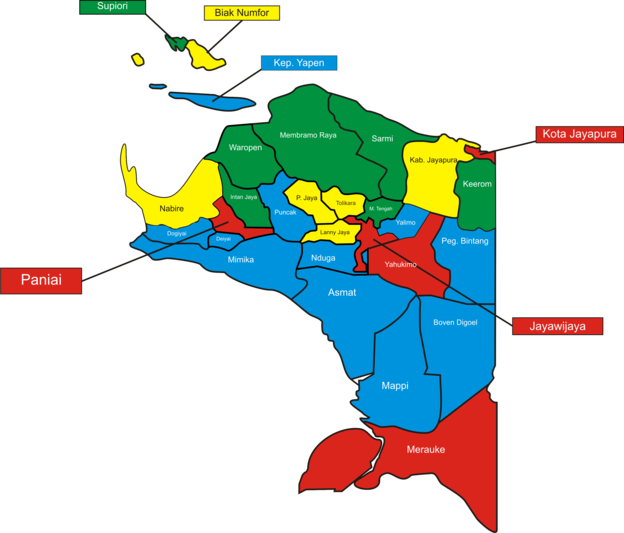
The regencies (kabupaten) and the city (kota) are listed below with their areas and their populations at the 2020 census, together with the 2020 Human Development Index of each adminstrative divisions.[88][89]
| hide | Regencies and Cities | Capital | Districts | Area (km2) | Population Census 2020 |
HDI (2020) |
|---|---|---|---|---|---|---|
| 1 | Abepura, Heram, Muara Tami, Jayapura Selatan, Jayapura Utara | 935.92 | 398,478 | 0.799 (High) | ||
| 2 | Agats | Agats, Akat, Atsy, Ayip, Betcbamu, Der Koumur, Fayit, Jetsy, Joerat, Kolf Braza, Kopay, Pantai Kasuari, Pulau Tiga, Safan, Sawa Erma, Sirets, Suator, Suru-suru, Unir Sirau | 31,983.43 | 110,105 | 0.506 (Low) | |
| 3 | Biak | Aimando Padaido, Andey, Biak Barat, Biak Kota (Biak), Biak Timur, Biak Utara, Bondifuar, Bruyadori, Numfor Barat, Numfor Timur, Oridek Orkeri, Padaido, Poiru, Samofa, Swandiwe, Warsa, Yawosi, Yendidori | 2,601.99 | 134,650 | 0.722 (High) | |
| 4 | Tanahmerah | Ambatkwi, Arimop, Bomakia, Firiwage, Fofi, Iniyandit, Jair, Kawagit, Ki, Kombay, Kombut, Kouh, Mandobo (Tanahmerah), Manggelum, Mindiptana, Ninati, Sesnuk, Subur, Waropko, Yaniruma | 27,108 | 64,285 | 0.615 (Medium) | |
| 5 | Waghete | Bowobado, Kapiraya, Tigi (Waghete), Tigi Barat, Tigi Timur | 537.39 | 99,091 | 0.495 (Low) | |
| 6 | Kigamani | Dogiyai, Kamu (Kigimani), Kamu Selatan, Kamu Timur, Kamu Utara, Mapia, Mapia Barat, Mapia Tengah, Piyaiye, Sukikai Selatan | 4,237.4 | 116,206 | 0.548 (Low) | |
| 7 | Sugapa | Agisiga, Biandoga, Hitadipa, Homeyo, Sugapa, Tomosiga, Ugimba, Wandai | 3,922.02 | 135,043 | 0.478 (Low) | |
| 8 | Sentani | Airu, Demta, Depapre, Ebungfau, Gresi Selatan, Kaureh, Kemtuk, Kemtuk Gresi, Namblong, Nimbokrang, Nimboran, Ravenirara, Sentani, Sentani Barat, Sentani Timur, Unurum Guay, Waibu, Yapsi, Yokari | 11,157.15 | 166,171 | 0.717 (High) | |
| 9 | Wamena | Asologaima, Asolokobal, Asotipo, Bolakme, Bpiri, Bugi, Hubikiak, Hubikosi, Ibele, Itlay Hisage, Koragi, Kurulu, Libarek, Maima, Molagalome, Muliama, Musatfak, Napua, Pelebaga, Piramid, Pisugi, Popugoba, Siepkosi, Silo Karno Doga, Taelarek, Tagime, Tagineri, Trikora, Usilimo, Wadangku, Walaik, Walelagama, Wame, Wamena, Welesi, Wesaput, Wita Waya, Wollo, Wouma, Yalengga | 7,030.66 | 269,553 | 0.580
(Medium) | |
| 10 | Waris | Arso, Arso Barat, Arso Timur, Kaisenar, Mannem, Senggi, Skanto, Towe, Waris, Web, Yaffi | 8,390 | 61,623 | 0.664
(Medium) | |
| 11 | Serui | Angkaisera, Anotaurei, Kepulauan Ambai, Kosiwo, Poom, Pulau Kurudu, Pulau Yerui, Raimbawi, Teluk Ampimoi, Windesi, Wonawa, Yapen Barat, Yapen Selatan (Serui), Yapen Timur, Yapen Utara, Yawakukat | 2,406.73 | 112,676 | 0.677
(Medium) | |
| 12 | Tiom | Awina, Ayumnati, Balingga, Balingga Barat, Bruwa, Buguk Gona, Dimba, Gamelia, Gelok Beam, Goa Balim, Gollo, Guna, Gupura, Karu, Kelulome, Kolawa, Kuly Lanny. Kuyawage, Lannyna, Makki, Melagi, Melagineri, Milimbo, Mokoni, Muara, Nikogwe, Niname, Nogi, Pirime, Poga, Tiom, Tiom Ollo, Tiomneri, Wano Barat, Wereka, Wiringgambut, Yiginua, Yiluk, Yugungwi | 6,448 | 196,399 | 0.479 (Low) | |
| 13 | Burmeso | Benuki, Mamberamo Hilir, Mamberamo Hulu, Mamberamo Tengah (Burmeso), Mamberamo Tengah Timur, Rufaer, Sawai, Waropen Atas | 23,813.91 | 36,483 | 0.518 (Low) | |
| 14 | Kobakma | Eragayam, Ilugwa, Kelila, Kobakma, Megambilis | 1,275 | 50,685 | 0.476 (Low) | |
| 15 | Kepi | Assue, Bamgi, Citak Mitak, Edera, Haju, Kaibar, Mambioman Bapai, Minyamur, Obaa (Kepi), Passue, Passue Bawah, Syahcame, Ti Zain, Venaha, Yakomi | 28,518 | 108,295 | 0.582
(Medium) | |
| 16 | Merauke | Animha, Elikobal, Ilwayab, Jagebob, Kaptel, Kimaam, Kurik, Malind, Merauke, Muting, Naukenjerai, Ngguti, Okaba, Semangga, Sota, Tabonji, Tanah Miring, Tubang, Ulilin, Waan | 46,791.63 | 230,932 | 0.701 (High) | |
| 17 | Timika | Agimuga, Alama, Amar, Hoya, Iwaka, Jila, Jita, Kuala Kencana, Kwamki Narama, Mimika Barat, Mimika Barat Jauh, Mimika Barat Tengah, Mimika Baru (Timika), Mimika Tengah, Mimika Timur, Mimika Timur Jauh, Tembagapura, Wania | 21,693.5 | 311,969 | 0.742 (High) | |
| 18 | Nabire | Dipa, Makimi, Menou, Moora, Nabire, Nabire Barat, Napan, Siriwo, Teluk Kimi, Teluk Umar, Uwapa, Wanggar, Wapoga, Yaro, Yaur | 12,010.65 | 169,136 | 0.688
(Medium) | |
| 19 | Kenyam | Alama, Dal, Embetpen, Gearek, Geselma, Inikgal, Iniye, Kegayem, Kenyam, Kilmid, Kora, Koroptak, Krepkuri, Mam, Mapenduma, Mbua Tengah, Mbulmu Yalma, Mbuwa, Mebarok, Moba, Mugi, Nenggeagin, Nirkuri, Paro, Pasir Putih, Pija, Wosak, Wusi, Wutpaga, Yal, Yenggelo, Yigi | 12,941 | 106,533 | 0.316 (Low) | |
| 20 | Enarotali | Aradide, Aweida, Baya Biru, Bibida, Bogabaida, Deiyai Miyo, Dogomo, Dumadama, Ekadide, Kebo, Muye, Nakama, Paniai Barat, Paniai Timur (Enarotali), Pugo Dagi, Siriwo, Teluk Deya, Topiyai, Wegee Bino, Wegee Muka, Yagai, Yatamo, Youtadi | 6,525.25 | 220,410 | 0.563
(Medium) | |
| 21 | Oksibil | Aboy, Alemsom, Awinbon, Batani, Batom, Bime, Borme, Eipumek, Iwur, Jetfa, Kalomdol, Kawor, Kiwirok, Kiwirok Timur, Mofinop, Murkim, Nongme, Ok Aom, Okbab, Okbape, Okbemtau, Okbibab, Okhika, Oklip, Oksamol, Oksebang, Oksibil, Oksop, Pamek, Pepera, Serambakon, Tarup, Teiraplu, Weime | 15,682 | 77,872 | 0.454 (Low) | |
| 22 | Ilaga | Agandugume, Amungkalpia, Beoga, Beoga Barat, Beoga Timur, Bina, Dervos, Doufo, Erelmakawia, Gome, Gome Utara, Ilaga, Ilaga Utara, Kembru, Lambewi, Mabugi, Mage'abume, Ogamanim, Omukia, Oneri, Pogoma, Sinak, Sinak Barat, Wangbe, Yugumuak | 8,055 | 114,741 | 0.430 (Low) | |
| 23 | Mulia | Dagai, Dokome, Fawi, Gubume, Gurage, Ilamburawi, Ilu, Irimuli, Kalome, Kiyage, Lumo, Mewoluk, Molanikime, Muara, Mulia, Nioga, Nume, Pagaleme, Taganombak, Tingginambut, Torere, Waegi, Wanwi, Yambi, Yamo, Yamoneri | 4,989.51 | 224,527 | 0.484 (Low) | |
| 24 | Sarmi | Apawer Hulu, Bonggo, Bonggo Timur, Pantai Barat, Pantai Timur, Pantai Timur Bagian Barat, Sarmi, Sarmi Selatan, Sarmi Timur, Tor Atas | 12,961.31 | 41,515 | 0.636
(Medium) | |
| 25 | Sorendiweri | Kepulauan Aruri, Supiori Barat, Supiori Selatan, Supiori Timur, Supiori Utara | 678.32 | 22,547 | 0.623
(Medium) | |
| 26 | Karubaga | Airgaram, Anawi, Aweku, Bewani, Biuk, Bogonuk, Bokondini, Bokoneri, Danime, Dow, Dundu, Egiam, Geya, Gika, Gilubandu, Goyage, Gundagi, Kai, Kamboneri, Kanggime, Karubaga, Kembu, Kondaga, Kuari, KubuLi Anogomma, Nabunage, Nelawi, Numba, Nunggawi, Panaga, Poganeri, Tagime, Tagineri, Telenggeme, Timori, Umagi, Wakuwo, Wari/Taiyeve II, Wenam, Wina, Woniki, Wugi, Wunim, Yuko, Yuneri | 5,588.13 | 236,986 | 0.495 (Low) | |
| 27 | Botawa | Demba, Inggerus, Kirihi, Masirei, Oudate, Risei Sayati, Soyoi Mambai, Urei Faisei, Wapoga, Waropen Bawah, Wonti | 10,502.39 | 33,943 | 0.649
(Medium) | |
| 28 | Dekai | Amuma, Anggruk, Bomela, Dekai, Dirwemna, Duram, Endomen, Hereapini, Hilipuk, Hogio, Holuon, Kabianggama, Kayo, Kona, Korupun, Kosarek, Kurima, Kwelemdua, Kwikma, Langda, Lolat, Mugi, Musaik, Nalca, Ninia, Nipsan, Obio, Panggema, Pasema, Pronggoli, Puldama, Samenage, Sela, Seredela, Silimo, Soba, Sobaham, Soloikma, Sumo, Suntamon, Suru Suru, Talambo, Tangma, Ubahak, Ubalihi, Ukha, Walma, Werima, Wusama, Yahuliambut, Yogosem | 17,152 | 350,880 | 0.494 (Low) | |
| 29 | Elelim | Abenaho, Apalapsili, Benawa, Elelim, Welarek | 3,568.52 | 101,973 | 0.483 (Low) | |
Environment[]
Geography and Climate[]
The island of New Guinea lies to the east of the Malay Archipelago, with which it is sometimes included as part of a greater Indo-Australian Archipelago.[90] Geologically it is a part of the same tectonic plate as Australia. When world sea levels were low, the two shared shorelines (which now lie 100 to 140 metres below sea level),[91] and combined with lands now inundated into the tectonic continent of Sahul,[92][93] also known as Greater Australia.[94] The two landmasses became separated when the area now known as the Torres Strait flooded after the end of the Last Glacial Period.
The province of Papua is located between 2 ° 25'LU – 9 ° S and 130 ° – 141 ° East. The total area of Papua is 317,062 km2 (122,418 sq. miles) or 19.33% of the total area of the Indonesian archipelago. Papua Province is the province that has the largest area in Indonesia. The boundaries of Papua are: Pacific Ocean (North), Arafura Sea (South), West Papua (West) and Papua New Guinea (East). Papua, like most parts of Indonesia, has two seasons, the dry season and the rainy season. From June to September the wind flows from Australia and does not contain much water vapor resulting in a dry season. On the other hand, from December to March, the wind currents contain a lot of water vapor originating from Asia and the Pacific Ocean so that the rainy season occurs. The average temperature in Papua ranges from 19 °C to 28 °C and humidity is between 80% to 89%. The average annual rainfall is between 1,500 mm to 7,500 mm.[95] Snowfalls sometime occurs in the mountainous areas of the province, especially the central highlands region.[96]

The New Guinea Highlands, which is located at the central east–west of the province, dominates the geography of the island of New Guinea, over 1,600 km (1,000 mi) in total length. The western section is around 600 km (400 mi) long and 100 km (60 mi) across. The province contains the highest mountains between the Himalayas and the Andes, rising up to 4,884 metres (16,024 ft) high, and ensuring a steady supply of rain from the tropical atmosphere.[97] The tree line is around 4,000 metres (13,000 ft) elevation and the tallest peaks contain permanent equatorial glaciers, increasingly melting due to a changing climate.[98][99] Various other smaller mountain ranges occur both north and west of the central ranges. Except in high elevations, most areas possess a hot, humid climate throughout the year, with some seasonal variation associated with the northeast monsoon season.
Another major habitat feature is the vast southern and northern lowlands. Stretching for hundreds of kilometers, these include lowland rainforests, extensive wetlands, savanna grasslands, and some of the largest expanses of mangrove forest in the world. The southern lowlands are the site of Lorentz National Park, a UNESCO World Heritage Site.[100] The northern lowlands are drained principally by the Mamberamo River and its tributaries on the western side, and by the Sepik on the eastern side. The more extensive southern lowlands are drained by a larger number of rivers, principally the Digul in the west and the Fly in the east. The largest island offshore, Dolak (also called Yos Sudarso), lies near the Digul estuary, separated by the narrow Muli Strait that is so narrow it has been named a "creek". The island is administered as part of the Merauke Regency.[101]
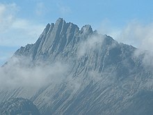
The province's largest river is the Mamberamo located in the northern part of the province. The result is a large area of lakes and rivers known as the Lakes Plains region. The Baliem Valley, home of the Dani people, is a tableland 1,600 metres (5,200 ft) above sea level in the midst of the central mountain range. Puncak Jaya, also known by its Dutch colonial name, "Carstensz Pyramid", is a limestone mountain peak 4,884 metres (16,024 ft) above sea level. It is the highest peak of Oceania.
Ecology[]
Anthropologically, New Guinea is considered part of Melanesia.[102] Botanically, New Guinea is considered part of Malesia, a floristic region that extends from the Malay Peninsula across Indonesia to New Guinea and the East Melanesian Islands. The flora of New Guinea is a mixture of many tropical rainforest species with origins in Asia, together with typically Australasian flora. Typical Southern Hemisphere flora include the Conifers Podocarpus and the rainforest emergents Araucaria and Agathis, as well as Tree ferns and several species of Eucalyptus.
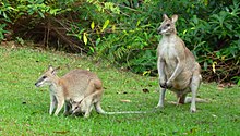
New Guinea is differentiated from its drier, flatter,[103] and less fertile[104][105] southern counterpart, Australia, by its much higher rainfall and its active volcanic geology. Yet the two land masses share a similar animal fauna, with marsupials, including wallabies and possums, and the egg-laying monotreme, the echidna. Other than bats and some two dozen indigenous rodent genera,[106] there are no pre-human indigenous placental mammals. Pigs, several additional species of rats, and the ancestor of the New Guinea singing dog were introduced with human colonization.
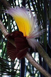
The island has an estimated 16,000 species of plant, 124 genera of which are endemic.[107] Papua's known forest fauna includes; marsupials (including possums, wallabies, tree-kangaroos, cuscuses); other mammals (including the endangered long-beaked echidna); bird species such as birds-of-paradise, cassowaries, parrots, and cockatoos; the world's longest lizards (Papua monitor); and the world's largest butterflies.[108]
The waterways and wetlands of Papua are also home to salt and freshwater crocodile, tree monitors, flying foxes, osprey, bats and other animals;[109] while the equatorial glacier fields remain largely unexplored.[110]
Protected areas within Papua province include the World Heritage Lorentz National Park, and the Wasur National Park, a Ramsar wetland of international importance.[111] Birdlife International has called Lorentz Park "probably the single most important reserve in New Guinea".[112] It contains five of World Wildlife Fund's "Global 200" ecoregions: Southern New Guinea Lowland Forests; New Guinea Montane Forests; New Guinea Central Range Subalpine Grasslands; New Guinea mangroves; and New Guinea Rivers and Streams.[113] Lorentz Park contains many unmapped and unexplored areas, and is certain to contain many species of plants and animals as yet unknown to Western science. Local communities' ethnobotanical and ethnozoological knowledge of the Lorentz biota is also very poorly documented. On the other hand, Wasur National Park has a very high value biodiversity has led to the park being dubbed the "Serengeti of Papua".[114] About 70% of the total area of the park consists of savanna (see Trans-Fly savanna and grasslands), while the remaining vegetation is swamp forest, monsoon forest, coastal forest, bamboo forest, grassy plains and large stretches of sago swamp forest. The dominant plants include Mangroves, Terminalia, and Melaleuca species.[114] The park provides habitat for a large variety of up to 358 bird species of which some 80 species are endemic to the island of New Guinea. Fish diversity is also high in the region with some 111 species found in the eco-region and a large number of these are recorded from Wasur.[111] The park's wetland provides habitat for various species of lobster and crab as well.
Several parts of the province remains unexplored due to steep terrain, leaving a high possibility that there are still many undiscovered floras and faunas that is yet to be discovered. In February 2006, a team of scientists exploring the Foja Mountains, Sarmi, discovered new species of birds, butterflies, amphibians, and plants, including possibly the largest-flowered species of rhododendron.[115] In December 2007, a second scientific expedition was taken to the mountain range. The expedition led to the discovery of two new species: the first being a 1.4 kg giant rat (Mallomys sp.) approximately five times the size of a regular brown rat, the second a pygmy possum (Cercartetus sp.) described by scientists as "one of the world's smallest marsupials."[116] An expedition late in 2008, backed by the Indonesian Institute of Sciences, National Geographic Society and Smithsonian Institution, was made in order to assess the area's biodiversity. New types of animals recorded include a frog with a long erectile nose, a large woolly rat, an imperial-pigeon with rust, grey and white plumage, a 25 cm gecko with claws rather than pads on its toes, and a small, 30 cm high, black forest wallaby (a member of the genus Dorcopsis).[117]
Ecological threats include logging-induced deforestation, forest conversion for plantation agriculture (including oil palm), smallholder agricultural conversion, the introduction and potential spread of alien species such as the crab-eating macaque which preys on and competes with indigenous species, the illegal species trade, and water pollution from oil and mining operations.[118]
Economy[]
Papua GDP share by sector (2005)[119]
Papua has large natural resources and a very large area. However, this province has weaknesses, namely limited infrastructure and less skilled human resources. So far, Papua has had a fairly good economic development due to the support of economic sources, especially mining, forest, agriculture and fisheries products.[120] Economic development has been uneven in Papua, and poverty in the region remains high by Indonesian standards.[121] Part of the problem has been neglect of the poor—too little or the wrong kind of government support from Jakarta and Jayapura. A major factor in this is the extraordinarily high cost of delivering goods and services to large numbers of isolated communities, in the absence of a developed road or river network (the latter in contrast to Kalimantan) providing access to the interior and the highlands. Intermittent political and military conflict and tight security controls have also contributed to the problem but with the exception of some border regions and a few pockets in the highlands, this has not been the main factor contributing to underdevelopment.[119]
Papua's gross domestic product grew at a faster rate than the national average until, and throughout the financial crisis of 1997–98.[119] However, the differences are much smaller if mining is excluded from the provincial GDP. Given that most mining revenues were commandeered by the central government until the Special Autonomy Law was passed in 2001, provincial GDP without mining is most likely a better measure of Papuan GDP during the pre- and immediate post-crisis periods. On a per capita basis, the GDP growth rates for both Papua and Indonesia are lower than those for total GDP. However, the gap between per capita GDP and total GDP is larger for Papua than for Indonesia as a whole, reflecting Papua's high population growth rates.[119]
Although Papua has experienced almost no growth in GDP, the situation is not as serious as one might think. It is true that the mining sector, dominated by Freeport Indonesia, has been declining over the last decade or so, leading to a fall in the value of exports. On the other hand, government spending and fixed capital investment have both grown, by well over 10 per cent per year, contributing to growth in sectors such as finance, construction, transport and communications, and trade, hotels and restaurants. With so many sectors still experiencing respectable levels of growth, the impact of the stagnant economy on the welfare of the population will probably be limited. It should also be remembered that mining is typically an enclave activity; its impact on the general public is fairly limited, regardless of whether it is booming or contracting.[122][123]
Papua has depended heavily on natural resources, especially the mining, oil and gas sectors, since the mid-1970s.[124][125] Although this is still the case, there have been some structural changes in the two provincial economies since the split in 2003. The contribution of mining to the economy of Papua province declined from 62 per cent in 2003 to 47 per cent in 2012. The shares of agriculture and manufacturing also fell, but that of utilities remained the same. A few other sectors, notably construction and services, increased their shares during the period. Despite these structural changes, the economy of Papua province continues to be dominated by the mining sector, and in particular by a single company, Freeport indonesia.[123]
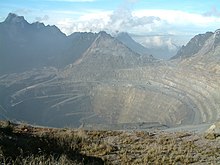
Mining is still and remains one of the dominant economic sector in Papua. The Grasberg Mine, the world's largest gold mine and second-largest copper mine,[126] is located in the highlands near Puncak Jaya, the highest mountain in Papua and whole Indonesia. Grasberg Mine producing 1.063 billion pounds of copper, 1.061 million ounces gold and 2.9 million ounces silver. It has 19,500 employees operated by PT Freeport Indonesia (PT-FI) which used to be 90.64% owned by Freeport-McMoran (FCX). In August 2017, FCX announced that it will divest its ownership in PT-FI so that Indonesia owns 51%. In return the CoW will be replaced by a special license (IUPK) with mining rights to 2041 and FCX will build a new smelter by 2022.[127][128]
Besides mining, there are at least three other important economic sectors (excluding the government sector) in the Papuan economy. The first is agriculture, particularly food crops, forestry and fisheries. Agriculture made up 10.4 per cent of provincial GDP in 2005 but grew at an average rate of only 0.1 per cent per annum in 2000–05. The second important sector is trade, hotels and restaurants, which contributed 4.0 per cent of provincial GDP in 2005. Within this sector, trade contributed most to provincial GDP. However, the subsector with the highest growth rate was hotels, which grew at 13.2 per cent per annum in 2000–05. The third important sector is transport and Communications, which contributed 3.4 per cent of provincial GDP in 2005. The sector grew at an average annual rate of 5.3 percent in 2000–05, slightly below the national level. Within the sector, sea transport, air transport and communications performed particularly well. The role of private enterprise in developing communications and air transport has become increasingly significant. Since private enterprise will only expand if businesspeople see good prospects to make a profit, this is certainly an encouraging development. At current rates of growth, the transport and communications sector could support the development of agriculture in Papua. However, so far, most of the growth in communications has been between the rapidly expanding urban areas of Jayapura, Timika, Merauke, and between them and the rest of Indonesia. Nevertheless, in the medium term, improved communication networks may create opportunities for Papua to shift from heavy dependence on the mining sector to greater reliance on the agricultural sector. With good international demand for palm oil anticipated in the medium term, production of this commodity could be expanded.[119] However, the negative effects of deforestation on the local environment should be a major consideration in the selection of new areas for this and any other plantation crop.[119] In 2011, Papuan caretaker governor Syamsul Arief Rivai claimed Papua's forests cover 42 million hectares with an estimated worth of Rp 700 trillion ($78 billion) and that if the forests were managed properly and sustainably, they could produce over 500 million cubic meters of logs per annum.[129]
Manufacturing and banking make up a tiny proportion of the regional economy and experienced negative growth in 2000–05.[119] Poor infrastructure and lack of human capital are the most likely reasons for the poor performance of manufacturing.[119] In addition, the costs of manufacturing are typically very high in Papua, as they are in many other outer island regions of Indonesia. Both within Indonesia and in the world economy, Papua's comparative advantage will continue to lie in agriculture and natural resource-based industries for a long time to come. A more significant role for manufacturing is unlikely given the far lower cost of labor and better infrastructure in Java. But provided that there are substantial improvements in infrastructure and communications, over the longer term manufacturing can be expected to cluster around activities related to agriculture—for example, food processing.[119]
Infrastructure[]
Compared to other parts of Indonesia, the infrastructure in Papua is one of the most least developed, owing to its distance from the national capital Jakarta. Nevertheless, for the past few years, the central government has invested significant sums of money to build and improve the current infrastructure in the province.[130] The infrastructure development efforts of the Ministry of Public Works and Housing in Papua have been very massive in the last 10 years. This effort is carried out to accelerate equitable development and support regional development in Papua. The main focus of infrastructure development in Papua is to improve regional connectivity, improve the quality of life through the provision of basic infrastructure and increase food security through the development of water resources infrastructure. The achievements and conditions of infrastructure development in Papua until 2017 have shown significant progress.[131]
Energy and water resources[]
Electricity distribution in the province as well as the whole country is operated and managed by the Perusahaan Listrik Negara (PLN). Originally, most Papuan villages do not have access to electricity. The Indonesia government through the Ministry of Energy and Mineral Resources, in the beginning of year 2016, introduced a program named "Indonesia Terang" or Bright Indonesia. The aimed of this program is to speed up Electrification Rate (ER) with priority to the six provinces at Eastern area of Indonesia including Papua Province. The target of Indonesian's ER by 2019 is 97%. While the Indonesian's national ER already high (88.30%) in 2015, Papua still the lowest ER (45.93%) among the provinces. The scenario to boost up ER in the Eastern area by connected the consumers at villages which not electrified yet to the new Renewable Energy sources.[132]
The percentage of household that were connected to the electricity in Papua (Electrification ratio/ER) is the lowest one among the provinces in Indonesia.[132] Data from the Ministry of Energy and Mineral Resources shows that only Papua Province has ER level below 50% (45.93%) with the national average RE was 88.30%.[132] High ER of more than 85% can be found in the rest of west area of the country. The main reason of lowest RE in Papua is a huge area with landlocked and mountain situation and low density population. Energy consumption in residential sector, 457 GWh in year 2014, contributes the electrification rate in Papua Province. But again, geographic and demographic obstacle made the electrical energy not well dispersed in Papua. The ER level are usually higher in the coastal area but become low in the mountain area.[132] The ongoing project of 35GW and Bright Indonesia proves that the government is focusing on improving electricity infrastructure in Papua. The target is 2.114 unelectrified villages in Papua and energy consumption each household will be 0.6 kWh/day. If they use Solar system to meet this consumption of energy, then each household should have been installed with at least 150 Wp solar home system (assuming the efficiency is 0.85 and minimum insulation is 5 hours/day).[132] As of 2019, there are still 1,724 villages in Papua and West Papua that have not received electricity, mostly in the inland regions.[133] Nevertheless, the Bright Indonesia program is considered to be a success, as more and more villages are receiving electricity for the first time.[134]
All pipes water supply in the province is managed by the Papua Municipal Waterworks (Indonesian: Perusahaan Daerah Air Minum Papua – PDAM Papua ). The supply of clean water is one of the main problem faced by the province, especially during drought seasons.[135] Papua has been named as the province with the worst sanitation in Indonesia, garnering a score of 45 while the national average is 75, due to unhealthy lifestyle habits and a lack of clean water. In response, the government has invested money to build the sufficient infrastructure to hold clean water.[136] Several new dams are also being build by the government throughout the province.[137]
Achieving universal access to drinking water, sanitation and hygiene is essential to accelerating progress in the fields of health, education and poverty alleviation. In 2015, about a quarter of the population used basic sanitation facilities at home, while a third still practiced open defecation. The coverage of improved drinking water sources is much higher, both in households and schools. Inequality based on income and residence levels is stark, demonstrating the importance of integrating equity principles into policy and practice and expanding the coverage of community-based total sanitation programs.[138]
Internet and telecommunication[]
Papua is the largest province in Indonesia, but it has the least amount of telecommunications services due to geographic isolation. The deployment of service to the district and to the sub district is still not evenly distributed. The distribution of telecommunication services in Papua is still very uneven. This is indicated by the percentage of the number of telecommunication services and infrastructure whose distribution is centralized in certain areas such as Jayapura. Based on data, the Human Development Index in Papua increases every year but is not accompanied by an increase adequate number of telecommunication facilities.[139]
The Ministry of Communication and Information Technology through the Information Technology Accessibility Agency (BAKTI) has built around 9 base transceiver stations in remote areas of Papua, namely Puncak Jaya Regency and Mamberamo Raya Regency, to connect to internet access. In the early stages, the internet was prioritized to support the continuity of education, health and better public services. To realize connectivity in accordance with government priorities, the Ministry of Communication and Information is determined to reach all districts in the Papua region with high-speed internet networks by 2020. It is planned that all districts in Papua and West Papua will build a fast internet backbone network. There are 31 regencies that have new high-speed internet access to be built.[140]
In late 2019, the government announced the completion of the Palapa Ring project – a priority infrastructure project that aimed to provide access to 4G internet services to more than 500 regencies across Indonesia, Papua included. The project is estimated to have cost US$1.5 billion and comprises 35,000 km (21,747 miles) of undersea fiber-optic cables and 21,000 km (13,000 miles) of land cables, stretching from the westernmost city in Indonesia, Sabang to the easternmost town, Merauke, which is located in Papua. Additionally, the cables also transverse every district from the northernmost island Miangas to the southernmost island, Rote. Through the Palapa Ring, the government can facilitate a network capacity of up to 100 Gbit/s in even the most outlying regions of the country.[141][142]
Transportation[]
Land[]

So far, air routes have been a mainstay in Papua and West Papua provinces as a means of transporting people and goods, including basic necessities, due to inadequate road infrastructure conditions. This has resulted in high distribution costs which have also increased the prices of various staple goods, especially in rural areas. Therefore, the government is trying to reduce distribution costs by building the Trans-Papua Highway.[143] As of 2016, the Trans-Papua highway that has been connected has reached 3,498 kilometers, with asphalt roads for 2,075 kilometers, while the rest are still dirt roads, and roads that have not been connected have reached 827 km. The development of the Trans-Papua highway will create connectivity between regions so that it can have an impact on the acceleration of economic growth in Papua and West Papua in the long term. Apart from the construction of the Trans-Papua highway, the government is also preparing for the first railway development project in Papua, which is currently entering the feasibility study phase. The said infrastructure funding for Papua is not insignificant. The need to connect all roads in Papua and West Papua is estimated at Rp. 12.5 trillion (US$870 million). In the 2016 State Budget, the government has also budgeted an additional infrastructure development fund of Rp. 1.8 trillion (US$126 million).[143]
Data from the Ministry of Public Works and Housing (KPUPR) states, the length of the Trans-Papua highway in Papua reaches 2,902 km. These include Merauke-Tanahmerah-Waropko (543 km), Waropko-Oksibil (136 km), Dekai-Oksibil (225 km), and Kenyam-Dekai (180 km). Then, Wamena-Habema-Kenyam-Mamug (295 km), Jayapura-Elelim-Wamena (585 km), Wamena-Mulia-Ilaga-Enarotali (466 km), Wagete-Timika (196 km), and Enarotali-Wagete-Nabire (285 km). As of 2020, only about 200–300 kilometers of the Trans-Papua highwat have not been connected.[144]
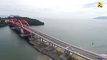
As in other provinces in Indonesia, Papua uses a dual carriageway with the left-hand traffic rule, and cities and towns such as Jayapura and Merauke provide public transportation services such as buses and taxis along with Gojek and Grab services.[145] Currently, the Youtefa Bridge in Jayapura is the longest bridge in the province, with a total length of 732 metres (2,402 ft).[146] The bridge cut the distance and travel time from Jayapura city center to Muara Tami district as well as Skouw State Border Post at Indonesia–Papua New Guinea border. The bridge construction was carried out by consortium of state-owned construction companies PT Pembangunan Perumahan Tbk, PT Hutama Karya (Persero), and PT Nindya Karya (Persero), with a total construction cost of IDR 1.87 trillion and support from the Ministry of Public Works and Housing worth IDR 1.3 trillion.[147] The main span assembly of the Youtefa Bridge was not carried out at the bridge site, but at PAL Indonesia shipyard in Surabaya, East Java. Its production in Surabaya aims to improve safety aspects, improve welding quality, and speed up the implementation time to 3 months. This is the first time where the arch bridge is made elsewhere and then brought to the location.[148] From Surabaya the bridge span, weighing 2000 tons and 112.5 m long, was sent by ship with a 3,200 kilometers journey in 19 days.[149][150] Installation of the first span was carried out on 21 February 2018, while the second span was installed on 15 March 2018 with an installation time of approximately 6 hours.[151] The bridge was inaugurated on 28 October 2019 by President Joko Widodo.[152]
A railway with a length of 205 km is being planned, which would connect the provincial capital Jayapura and Sarmi to the east. Further plans include connecting the railway to Sorong and Manokwari in West Papua. In total, the railway would have a length of 595 km, forming part of the Trans-Papua Railway.[153] Construction of the railway is still in the planning stage.[154] A Light Rapid Transport (LRT) connecting Jayapura and Sentani is also being planned.[155]
Air[]

The geographical conditions of Papua which are hilly and have dense forests and do not have adequate road infrastructure, such as in Java or Sumatra, make transportation a major obstacle for local communities. Air transportation using airplanes is by far the most effective means of transportation and is needed most by the inhabitants of the island, although it is not cheap for it. A number of airlines are also scrambling to take advantage of the geographical conditions of the island by opening busy routes to and from a number of cities, both district and provincial capitals. If seen from the sufficient condition of the airport infrastructure, there are not a few airports that can be landed by jets like Boeing and Airbus as well as propeller planes such as ATR and Cessna.[156]
Sentani International Airport in Jayapura is the largest airport in the province, serving as the main gateway to the province from other parts of Indonesia. The air traffic is roughly divided between flights connecting to destinations within the Papua province and flights linking Papua to other parts of Indonesia. The airport connects Jayapura with other Indonesian cities such as Manado, Makassar, Surabaya and Jakarta, as well as towns within the province such as Biak, Timika and Merauke. Sentani International Airport is also the main base for several aviation organizations, including Associated Mission Aviation, Mission Aviation Fellowship, YAJASI and Tariku Aviation. The airport currently does not have any international flights, although there are plans to open new airline routes to neighboring Papua New Guinea in the future.[157] Other medium-sized airports in the province are Mozes Kilangin Airport in Timika, Mopah International Airport in Merauke, Frans Kaisiepo International Airport in Biak, and Wamena Airport in Wamena. There are over 300 documented airstrips in Papua, consists of mostly small airstrips that can only be landed by small airplanes.[158] The government is planning to open more airports in the future to connect isolated regions in the province.[159]
Water[]
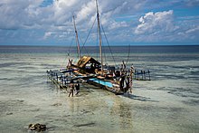
Water transportation, which includes sea and river transportation, is also one of the most crucial form of transportation in the province, after air transportation. The number of passengers departing by sea in Papua in October 2019 decreased by 16.03 percent, from 18,785 people in September 2019 to 15,773 people.[160] The number of passengers arriving by sea in October 2019 decreased by 12.32 percent, from 11,108 people in September 2019 to 9,739 people. The volume of goods loaded in October 2019 was recorded at 17,043 tons, an increase of 30.57 percent compared to the volume in September 2019 which amounted to 13,053 tons. The volume of goods unloaded in October 2019 was recorded at 117,906 tons or a decrease of 2.03 percent compared to the volume in September 2019 which amounted to 120,349 tons.[160]
There are several ports in the province, with the Port of Depapre in Jayapura being the largest, which started operation in 2021.[161][162] There are also small to medium-sized ports in Biak, Timika, Merauke and Agats, which serves passenger and cargo ships within the province, as well as from other Indonesian provinces.
Healthcare[]
Health-related matters in the Riau Islands is administered by the Papua Provincial Health Agency (Indonesian: Dinas Kesehatan Provinsi Papua).[163] According to the Indonesian Central Agency on Statistics, as of 2015, there are around 13,554 hospitals in Papua which consists of 226 state-owned hospitals and 13,328 private hospitals.[164] Furthermore, there are 394 clinics spread throughout the province.[164] Lack of good healthcare infrastructure is one of the main issues in Papua as of today, especially in the remote regions, as most hospitals that have adequate facilities are only located at major cities and towns.. A measles outbreak and famine killed at least 72 people in Asmat regency in early 2018,[165][166] during which 652 children were affected by measles and 223 suffered from malnutrition.[167][168]
The most prominent hospital is the Papua Regional General Hospital (Indonesian: Rumah Sakit Umum Daerah Papua) in Jayapura, which is the largest state-owned hospital in the province.[169]
Education[]
Main articles: List of universities in Indonesia
Education in Papua, as well as Indonesia in a whole, falls under the responsibility of the Ministry of Education and Culture (Kementerian Pendidikan dan Kebudayaan or Kemdikbud) and the Ministry of Religious Affairs (Kementerian Agama or Kemenag). In Indonesia, all citizens must undertake twelve years of compulsory education which consists of six years at elementary level and three each at middle and high school levels. Islamic schools are under the responsibility of the Ministry of Religious Affairs. The Constitution also notes that there are two types of education in Indonesia: formal and non-formal. Formal education is further divided into three levels: primary, secondary and tertiary education. Indonesians are required to attend 12 years of school, which consists of three years of primary school, three years of secondary school and three years of high school.[170]
As of 2015, there are 3 public universities and 40 private universities in Papua.[171] Public universities in the Riau Islands falls under the responsibility of the Ministry of Research and Technology (Kementerian Riset dan Teknologi) as well as the Ministry of Education and Culture. The most famous university in the province is the Cenderawasih University in Jayapura. The university has faculties in economics, law, teacher training and education, medical, engineering, and social and political science. Until 2002 the university had a faculty of agricultural sciences at Manokwari, which was then separated to form the Universitas Negeri Papua.
Demographics[]
While the Papuan branch of the Central Agency on Statistics had earlier projected the 2020 population of the province to be 3,435,430 people[88][172] the actual Census in 2020 revealed a total population of 4,303,707,[15] spread throughout 28 regencies and 1 administrative city. The city of Jayapura is the most populated administrative division in the province, with a total of 398,478 people in 2020, while Supiori Regency, which comprises mainly the island of Supiori, one of the Schouten Islands within Cenderawasih Bay off the north coast of Papua, is the least populated administrative division in the province, with just 22,547 people.[88] Most of the population in the province are concentrated in coastal regions, especially around the city of Jayapura and its suburbs. Papua is also home to many migrants from other parts of Indonesia, of which an overwhelming percentage of these migrants came as part of a government-sponsored transmigration program.[173] The transmigration program in Papua was only formally halted by President Joko Widodo in June 2015.[174]
Ethnicity[]

In contrast to other Indonesian provinces, which are mostly dominated by Austronesian peoples, Papua and West Papua as well as some part of Maluku are home to the Melanesians. The indigenous Papuans which are part of the Melanesians forms the majority of the population in the province. Many believe human habitation on the island dates to as early as 50,000 BC,[175] and first settlement possibly dating back to 60,000 years ago has been proposed. The island of New Guinea is presently populated by almost a thousand different tribal groups and a near-equivalent number of separate languages, which makes it the most linguistically diverse area in the world. Current evidence indicates that the Papuans (who constitute the majority of the island's peoples) are descended from the earliest human inhabitants of New Guinea. These original inhabitants first arrived in New Guinea at a time (either side of the Last Glacial Maximum, approx 21,000 years ago) when the island was connected to the Australian continent via a land bridge, forming the landmass of Sahul. These peoples had made the (shortened) sea-crossing from the islands of Wallacea and Sundaland (the present Malay Archipelago) by at least 40,000 years ago.
Notable Papuan tribes include the Asmat people who inhabits the Asmat Swamp as well as some part of the Lorentz National Park in the Asmat Regency. The Asmat inhabit a region on the island's southwestern coast bordering the Arafura Sea, with lands totaling approximately 18,000 km2 (7,336 mi2) and consisting of mangrove, tidal swamp, freshwater swamp, and lowland rainforest.[176] The Dani people who inhabits the Baliem Valley in the highlands, including the town of Wamena and are considered to be one of the most populated tribes of the province. The Marind people of Southern Papua occupies a vast territory, which is situated on either side of the Bian River, from about 20 miles to the east of Merauke, up to the mouth of the Moeli River in the west (between Frederik Hendrik Island and the mainland; east of Yos Sudarso Island, mainly west of the Maro River (a small area goes beyond the Maro at its lower part, including Merauke).[177]
The ancestral Austronesian peoples are believed to have arrived considerably later, approximately 3,500 years ago, as part of a gradual seafaring migration from Southeast Asia, possibly originating in Taiwan. Austronesian-speaking peoples colonized many of the offshore islands to the north and east of New Guinea, such as New Ireland and New Britain, with settlements also on the coastal fringes of the main island in places. Human habitation of New Guinea over tens of thousands of years has led to a great deal of diversity, which was further increased by the later arrival of the Austronesians and the more recent history of European and Asian settlement.[178]
Papuan is also home to ethnic groups from other part of Indonesia, including the Javanese, Sundanese, Balinese, Batak, etc.[179] Most of these migrants came as part of the transmigration program, which was an initiative of the Dutch colonial government and later continued by the Indonesian government to move landless people from densely populated areas of Indonesia to less populous areas of the country.[180] The program was criticized by human rights activists, claiming that the program is part of "an attempt to wipe out the Papuans in a slow-motion genocide".[181] There is open conflict between migrants, the state, and indigenous groups due to differences in culture—particularly in administration, and cultural topics such as nudity, food and sex.[182] The transmigration program in Papua was stopped in 2015 due to the controversies it had caused.[183]
Language[]

Papua, the easternmost region of the Indonesian archipelago, exhibits a very complex linguistic network. The diversity of languages and the situation of multilingualism is very real. There are many language families scattered in this wide area, namely the Austronesian language family and numerous non-Austronesian languages known collectively as Papuan languages. Speakers of different Austronesian languages are found in coastal communities, such as Biak, Wandamen, Waropen and Ma'ya. On the other hand, Papuan languages are spoken in the interior and Central Highlands, starting from the Bird's Head Peninsula in the west to the eastern tip of the island of New Guinea, for example Meybrat, Dani, Ekari, Asmat, Muyu and Sentani language.[184][185]
At this time, research efforts to find out how many indigenous languages in Papua are still being pursued. Important efforts regarding documentation and inventory of languages in Papua have also been carried out by two main agencies, namely SIL International and the Language and Book Development Agency in Jakarta. The results of the research that have been published by the two institutions show that there are differences in the number of regional languages in Papua. The Language and Book Development Agency as the official Indonesian government agency has announced or published that there are 207 different regional languages in Papua, while SIL International has stated that there are 271 regional languages in the region.[186][185] Some of the regional languages of Papua are spoken by a large number of speakers and a wide spread area, some are supported by a small number of speakers and are scattered in a limited environment. However, until now it is estimated that there are still a number of regional languages in Papua that have not been properly studied so that it is not known what the form of the language is. In addition to local languages that have been listed by the two main institutions above, there are also dozens more languages from other islands due to population migration that is not included in the list of local languages in Papua, for example languages from Sulawesi (Bugis, Makassar, Toraja, Minahasa), Javanese from Java, and local languages from Maluku.[185] So-called Papuan languages comprise hundreds of different languages, most of which are not related.[187]
As in other provinces, Indonesian is the official language of the state, as well as the province.[188] Indonesian is used in inter-ethnic communication, usually between native Papuans and non-Papuan migrants who came from other parts of Indonesia. Most formal education, and nearly all national mass media, governance, administration, judiciary, and other forms of communication in Papua, are conducted in Indonesian.[189] A Malay-based creole language called Papuan Malay is used as the lingua franca in the province. It emerged as a contact language among tribes in Indonesian New Guinea for trading and daily communication. Nowadays, it has a growing number of native speakers. More recently, the vernacular of Indonesian Papuans has been influenced by Standard Indonesian, the national standard dialect. Some linguists have suggested that Papuan Malay has its roots in North Moluccan Malay, as evidenced by the number of Ternate loanwords in its lexicon.[190] Others have proposed that it is derived from Ambonese Malay.[191] A large number of local languages are spoken in the province, and the need for a common lingua franca has been underlined by the centuries-old traditions of inter-group interaction in the form of slave-hunting, adoption, and intermarriage.[185] It is likely that Malay was first introduced by the Biak people, who had contacts with the Sultanate of Tidore, and later, in the 19th century, by traders from China and South Sulawesi. However, Malay was probably not widespread until the adoption of the language by the Dutch missionaries who arrived in the early 20th century and were then followed in this practice by the Dutch administrators.[192] The spread of Malay into the more distant areas was further facilitated by the Opleiding tot Dorpsonderwizer ('Education for village teacher') program during the Dutch colonial era.[193] There are four varieties of Papuan Malay that can be identified, including Serui Malay.[191] A variety of Papuan Malay is spoken in Vanimo, Papua New Guinea near the Indonesian border.[194]
Religion[]
Religion in Papua
According to the 2010 national census, 84.42% of the Papuans identified themselves as Christians, with 69.02% being Protestants and 15.4% being Catholics. 15.29% of the population are Muslims and less than 1% were Buddhists or Hindus.[195] There is also substantial practice of animism, the traditional religion for many Papuans, with many blending animistic beliefs with other religions such as Christianity. Christianity, including Protestantism and Roman Catholic are mostly adhered by native Papuans and migrants from Maluku, East Nusa Tenggara and North Sulawesi. Islam are mostly adhered by migrants from western Indonesia, some Moluccans and some native Papuans. Lastly Hinduism and Buddhism are mostly adhered by Balinese migrants and Chinese-Indonesians respectively.
Missionaries Carl Ottow and Johann Geisler, under the initiative of Ottho Gerhard Heldring and permission from Tidore Sultanate,[196] are the first Christian missionaries that reached Papua. They entered Papua at Mansinam Island, near Manokwari on 5 February 1855.[197] Since 2001, the fifth of February has been a Papuan public holiday, recognizing this first landing.[198] In 1863, sponsored by the Dutch colonial government, the Utrecht Mission Society (UZV) started a Christian-based education system as well as regular church services in Western New Guinea.[198] Initially the Papuans' attendance was encouraged using bribes of betel nut and tobacco, but subsequently this was stopped. In addition, slaves were bought to be raised as step children and then freed. By 1880, only 20 Papuans had been baptized, including many freed slaves. The Dutch government established posts in Netherlands New Guinea in 1898, a move welcomed by the missionaries, who saw orderly Dutch rule as the essential antidote to Papua paganism.[198] Subsequently, the UZV mission had more success, with a mass conversion near Cenderawasih Bay in 1907 and the evangelization of the Sentani people by Pamai, a native Papuan in the late 1920s.[198] Due to the Great Depression, the mission suffered a funding shortfall, and switched to native evangelists, who had the advantage of speaking the local language (rather than Malay), but were often poorly trained. The mission extended in the 1930s to Yos Sudarso Bay, and the UZV mission by 1934 had over 50,000 Christians, 90% of them in North Papua, the remainder in West Papua.[198] By 1942 the mission had expanded to 300 schools in 300 congregations. The first Catholic presence in Papua was in Fakfak, a Jesuit mission in 1894. In 1902 the Vicariate of Netherlands New Guinea was established. Despite the earlier activity in Fakfak, the Dutch restricted the Catholic Church to the southern part of the island, where they were active especially around Merauke. The mission campaigned against promiscuity and the destructive practices of headhunting among the Marind-anim.[198] Following the 1918 flu pandemic, which killed one in five in the area, the Dutch government agreed to the establishment of model villages, based on European conditions, including wearing European clothes, but which the people would submit to only by violence. In 1925 the Catholics sought to re-establish their mission in Fakfak; permission was granted in 1927. This brought the Catholics into conflict with the Protestants in North Papua, who suggested expanding to South Papua in retaliation.[199]
Culture[]

The native Papuan people has a distinct culture and traditions that cannot be found in other parts of Indonesia. Coastal Papuans are usually more willing to accept modern influence into their daily lives, which in turn diminishes their original culture and traditions. Meanwhile, most inland Papuans still preserves their original culture and traditions, although their way of life over the past century are tied to the encroachment of modernity and globalization.[200] Each Papuan tribe usually practices their own tradition and culture, which may differ greatly from one tribe to another.
One of the most well-known Papuan tradition is the stone burning tradition (Indonesian: Tradisi Bakar Batu), which is practiced by most Papuan tribes in the province. The stone burning tradition is an important tradition for all indigenous Papuans. For them, is a form of gratitude and a gathering place between residents of the village. This tradition is usually held when there are births, traditional marriages, the coronation of tribal chiefs, and the gathering of soldiers. It is usually carried out by indigenous Papuan people who live in the interior, such as in the Baliem Valley, Panaiai, Nabire, Pegunungan Bintang, and others. other. The name of this tradition varies in each region. In Paniai, the stone burning tradition is called Gapiia. Meanwhile, in Wamena it is called Kit Oba Isogoa, while in Jayawijaya it is called Barapen. It is called the stone burning tradition because the stone is actually burned until it is hot. The function of the hot stone is to cook meat, Sweet potatoes, and vegetables on the basis of banana leaves which will be eaten by all residents at the ongoing event.[201][202] In some remote Papuan communities who are Muslim or when welcoming Muslim guests, pork can be replaced with chicken or beef or mutton or can be cooked separately with pork. This is, for example, practiced by the Walesi community in Jayawijaya Regency to welcome the holy month of Ramadan.[203]
The finger cutting tradition (Indonesian: Tradisi Potong Jari) is practiced among the Dani people of the Baliem Valley in central Papua.[201] The tradition of cutting fingers on the Dani people has existed since ancient times and is still being carried out today. This tradition symbolizes harmony, unity, and strength that comes from within a person and within a family. According to the culture of the Dani people, family is the most valuable pedestal that a human has, fingers are believed to symbolize the existence and function of a family itself. So that the tradition of cutting is carried out when someone loses a family member or relative such as husband, wife, children, younger siblings and older siblings forever. For Dani people, sadness and grief due to adversity and the loss of a family member are not only appreciated by crying, but also cutting fingers. The Dani people believes that cutting off a finger is a symbol of the sadness and pain of losing a family member. The finger-cutting tradition is also seen as a way to prevent the recurrence of a catastrophe that claimed the life of a grieving family member.[201][204]
The Ararem tradition is the tradition of delivering the dowry of a future husband to the family of the prospective wife in the Biak custom. In the Biak language, the word "Ararem" means dowry. In this procession, the bride and groom will be escorted on foot in a procession, accompanied by songs and dances accompanied by music and. The amount of the dowry is determined by the woman's family as agreed by her relatives. The date of submission of the dowry must be agreed upon by the family of the woman or the family of the prospective wife and the family of the man or family of the prospective husband. In the tradition of the Biak people, the payment of the dowry is a tradition that must be obeyed because it involves the consequences of a marriage.[201][205][206]
Arts and Performance[]

There are a lot of traditional dances that are native to the province of Papua. Each Papuan tribes would usually have their own unique traditional dances.
The Yospan dance (Indonesian: Tarian Yospan) is a type of social association dance in Papua which is a traditional dance originating from the coastal regions of Papua, namely Biak, Yapen and Waropen, which are often played by the younger people as a form of friendship.[207] Initially, the Yospan dance originated from two dances called Yosim and Pancar, which were eventually combined into one. Hence, Yospan is an acronym of Yosim and Pancar.[207] When performing the Yosim dance, which originated from Yapen and Waropen, the dancers invited other residents to be immersed in the songs sung by a group of singers and music instrument holders. The musical instruments used are simple, which consists of ukulele and guitar, musical instruments that are not native to Papua. There is also a tool that functions as a bass with three ropes. The rope is usually made from rolled fibers, a type of pandanus leaf, which can be found in the forests of the coastal areas of Papua. A music instrument called Kalabasa is also played during the dance, it is made of dried pumpkin, then filled with beads or small stones that are played by simply shaking it.[208] The women dancers wear woven sarongs to cover their chests, decorative heads with flowers and bird feathers.[209] Meanwhile, the male dancers would usually wear shorts, open chest, head also decorated with bird feathers. The Pancar dance that originated from Biak is only accompanied by a tifa, which is the traditional musical instrument of the coastal tribes in Papua.[207]
The Isosolo dance is a type of dance performed by the inhabitants who lives around Lake Sentani in Jayapura. The Isosolo dance is performed to symbolize the harmony between different tribes in Papua. The art of boat dancing is a tradition of the Papuan people, especially among the Sentani people, where the dance is performed from one village to another. According to the Sentani language, Isosolo or Isolo dance is a traditional art of the Sentani people who dance on a boat on Lake Sentani. The word Isosolo consists of two words, iso and solo (or holo). Iso means to rejoice and dance to express feelings of the heart, while holo means a group or herd from all age groups who dance. Hence, isosolo means a group of people who dance with joy to express their feelings.[210] The Isosolo dance in Sentani is usually performed by ondofolo (traditional leaders) and the village community to present a gift to other ondofolo. Items that are offered are items that are considered valuable, such as large wild boar, garden products, delivering ondofolo girls to be married, and several other traditional gifts. However, at this time, apart from being a form of respect for ondoafi, isosolo is considered more as a performance of the Sentani people's pride which is one of the popular attractions at the Lake Sentani Festival, which is held annually.[210][211]
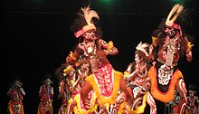
Each Papuan tribe usually has their own war dance. The Papuan war dance is one of the oldest dances of the Papuan people because this classical dance has been around for thousands of years and is even one of the legacies of Indonesia's prehistoric times. In Papuan culture, this dance is a symbol of how strong and brave the Papuan people are. Allegedly, this dance was once a part of traditional ceremonies when fighting other tribes. The dancers who perform this dance are a group of men, the number starts from seven people or more. They danced to the sound of drums and war songs. Their movements were characteristically excited as if they were warriors heading for battle. The Papuan war dance is very unique, varied and energetic to indicate the heroism and courage of the Papuan people. Apart from the dancers movements in playing the weapons they carry, the uniqueness of this dance is also seen in the dancers' clothes.[212]
Another traditional dance that is common to most if not all Papuan tribes is called musyoh. The emergence of the musyoh dance is based on a certain history. In ancient times, when a Papuan tribe member died due to an accident or something unexpected, the Papuan people believed that the spirit of the person who died was still roaming and unsettled. To overcome this, the Papuan tribesmen created a ritual in the form of the musyoh dance. Thus, this traditional dance is often referred to as a spirit exorcism dance. Generally, the musyoh dance is performed by men. However, besides the purpose of exorcising spirits, the musyoh dance is also used by the Papuan people for another purpose, such as welcoming guests. The musyoh dance is a symbol of respect, gratitude, and an expression of happiness in welcoming guests. If it is for the purpose of expelling the spirit, this musyoh dance is performed by men. In the case for welcoming guests, this dance is performed by men and women. The costumes worn by the dancers can be said to be very simple costumes. This simplicity can be seen from its very natural ingredients, namely processed tree bark and plant roots. The material is then used as a head covering, tops and bottoms, bracelets and necklaces. There are also unique scribbles on the dancers' bodies that show the uniqueness of the dance.[213]
Architecture[]

Papua is famous for its varieties of traditional houses, one of which is a traditional house called honai. Honai is a traditional Papuan house, especially in the mountainous region.[214] The basic shape of the honai is a circle with a wooden frame and woven walls and a conical roof made of straw. The honai is spread across almost all corners of the Baliem Valley which covers an area of 1,200 square kilometers. The distance from the surface of the house to the ceiling is only about 1 meter. Within the honai, there is a fireplace which is located right in the middle. The thatched roof and wooden walls of the Honai actually bring cool air inside If the air is too cold, the whole house will be warmed by the smoke from the fireplace. For the Dani people, smoke from firewood is no longer unusual for being smoked for a long time. As long as the door is still open, oxygen can still flow inside.[214] The honai is supported by 4 main poles called heseke, which are stuck in the ground at a certain distance (about 1 meter) so that they are square. In the middle of this main pillar is placed a fireplace called a round wulikin. An honai is made in an attic so that it is divided into two rooms, at the top it is called henaepu as a bed and the bottom is called agarowa as a place to rest, tell stories or chat, and eat. The upper part of the attic or floor is made of fruit wood and covered with woven lokop wood (a kind of very small bamboo) and can be covered again with straw or dry grass. There is usually only one door in the honai, which is small and short so that people come out and enter on all fours. To the left or right of the entrance is a door leading to the attic.[214]
The kariwari is one of the traditional Papuan houses, more precisely the traditional house of the Tobati-Enggros people who live around Yotefa Bay and Lake Sentani near Jayapura.[215] Unlike other forms of Papuan traditional houses, such as the round honai, the kariwari is usually constructed in the shape of an octagonal pyramid. Kariwari are usually made of, bamboo, iron wood and forest sago leaves. The Kariwari house consists of two floors and three rooms or three rooms, each with different functions. The kariwari is not like a honai that can be lived in by anyone, it cannot even be the residence of a tribal chief – unlike the honai which has political and legal functions. The kariwari is more specific as a place of education and worship, therefore the position of the Kariwari in the community of the Tobati-Enggros people is considered a sacred and holy place.[215] Like traditional houses in general, the kariwari also has a design that is full of decorative details that make it unique, of course, the decorations are related to Papuan culture. especially from the Tobati-Enggros. The decorations found in the kariwari are usually in the form of works of art, among others; paintings, carvings and also sculptures. Apart from being decorated with works of art, the kariwari is also decorated with various weapons, such as; bow and arrow. There are also some skeletons of prey animals, usually in the form of wild boar fangs, kangaroo skeletons, turtle or turtle shells, birds-of-paradise, and so on.[216]
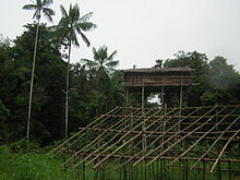
Rumsram is the traditional house of the Biak Numfor people on the northern coast of Papua. This house was originally intended for men, while women were prohibited from entering or approaching it. Its function is similar to the kariwari, namely as a place for activities in teaching and educating men who are starting to be teenagers, in seeking life experiences. The building is square with a roof in the shape of an upside down boat because of the background of the Biak Numfor tribe who work as sailors. The materials used are bark for floors, split and chopped water bamboo for walls, while the roof is made of dried sago leaves. The walls are made of sago leaves. The original rumsram wall only had a few windows and its position was at the front and back. A rumsram usually has a height of approximately 6–8 m and is divided into two parts, differentiated by floor levels. The first floor is open and without walls. Only the building columns were visible. In this place, men are educated to learn sculpting, shielding, boat building, and war techniques. In a traditional ceremony called Wor Kapanaknik, which in the Biak language means "to shave a child's hair", a traditional ritual is usually carried out when boys are 6–8 years old. The age when a child is considered to be able to think and the child has started to get education in the search for life experiences, as well as how to become a strong and responsible man as the head of the family later. The children would then enter a rumsram, hence the rite of passage is also called rumsram, because the ritual are carried out in the rumsram.[217]
The Korowai people from the Mappi Regency in southern Papua is one of the indigenous tribes in Papua that still adheres to the traditions of their ancestors, one of which is to build houses on top of trees.[218][219] The Korowai people is one of the indigenous tribes in the interior of Papua that still maintains firmly the traditions of their ancestors, one of which is to build a house on a tall tree called Rumah Tinggi (lit. 'high house'). Some of the Korowai people's tree houses can even reach a height of 50 m above the ground. The Korowai people builds houses on top of trees to avoid wild animals and evil spirits. The Korowai people still believes in the myth of Laleo, a cruel demon who often attacks suddenly. Laleo is depicted as an undead that roams at night. According to the Korowai people, the higher the house, the safer it will be from Laleo's attacks. The rumah tinggi is built on big and sturdy trees as the foundation for its foundation. The tops of the trees are then deforested and used as houses. All materials come from nature, logs and boards are used for the roof and floor, while the walls are made of sago bark and wide leaves. The building process for a rumah tinggi usually takes seven days and lasts up to three years.[219]
Traditional Weapon[]

The cuscus bone skewer is a traditional Papuan weapon used by one of the indigenous Papuan tribes, namely the Bauzi people. The Bauzi people still maintains their tradition of hunting and gathering. The weapon they use to hunt animals while waiting for the harvest to arrive is a piercing tool made of cuscus bones. The use of cuscus bones as a traditional weapon is very environmentally friendly. This happens because in its manufacture, it does not require the help of industrial equipment that pollutes the environment. This traditional weapon is made from cleaned cuscus bone (before the meat is eaten and separated from the bone), sharpened by rubbing it with a whetstone, and repeated so that the desired sharpness is formed.[220]
Papuan knife blades are usually used for slashing or cutting when hunting animals in the forest. Even though the animals they face are large mammals and crocodiles, the Papuan people still adhere to prevailing customs. The custom is that it is not permissible to use any kind of firearm when hunting. Papuan Daggers are knives made of unique materials and are difficult to obtain in other areas, namely the bones of an endemic animal to Papua, the cassowary. Cassowary bones are used by local culture to become a tool that has beneficial values for life. Apart from that, the feathers attached to the blade's handle are also the feathers of the cassowary.[220]
The Papuan spear is referred to by the local community as "Tul". The spear was a weapon that could be used for both fighting and hunting. In addition, Papuan culture often uses the spear as a property in dances. The weapons mentioned above are made from basic materials that are easily found in nature. Wood to make the handle, and a river stone that was sharpened as a spearhead. For that reason, the spear is able to survive as a weapon that must be present in hunting and fighting activities. What makes this traditional Papuan weapon feel special is that there is a rule not to use a spear other than for hunting and fighting purposes. For example, it is forbidden to cut young tree shoots with a spear, or to use a spear to carry garden produce. If this rule was broken, the person who wielded this spear would have bad luck. Meanwhile, in the manufacturing process, this spear frame takes a long time. Starting from the wood taken from the tree, then cut to the size of 3 m in a state that has been dried in the sun. After drying it in the sun, the wood for the handle is shaped in such a way, then rubbed with sea snail powder until it is sharp, which takes about 1 week. In traditional Papuan customs, the spear is interpreted as a symbol of a man's prowess. Therefore, the spears must always be properly stored. Usually hung from the ceiling or placed on a house wall support.[220]
The bow and arrow is a traditional Papuan weapon that has uses for hunting wild boar and other animals. In addition, the Papuan bow and arrow were tools that were always carried side by side with the spear. Another use of the arrow is a tool for warfare. The difference lies in the material used in the arrowheads. If the aim is to hunt animals, then the arrowheads used are made of bamboo. Meanwhile, when going to war, the indigenous tribes in Papua have rules that require that the spearhead used is made of animal bones. In addition, arrows also function as property for home decoration in several areas in Papua, including Jayapura, Wamena, and Kurulu. In these areas, arrows are only intended for house collections. The collection of bows and arrows is also not allowed to be placed carelessly, that is, they are placed on the wall of the house to still respect the culture of the services of the arrow.[220]
The Papuan parang is a symbol of the strength and tenacity of a man in the household. Parang by the local community is called by the name "jalowy". In the manufacturing process, this Papuan machete takes a lot of time. Derived from a split stone, then sharpened to form a machete that has sharpness. To increase the level of hardness and durability, machete craftsmen always add pork oil and pork blood before sharpening it until it is smooth and sharp. This Papuan parang basically has many uses. For household purposes, namely cooking, cutting meat, and cutting down sago. In addition, Papuan machetes are also used in the agricultural industry, and can even be used as a tool to propose to a potential partner. Furthermore, parang can also be used as a collection.[220]
Papuan Chisels are traditional Papuan weapons that have various uses, such as cutting rattan for weaving, tools for punching holes in wood, as well as emergency tools for stabbing enemies in the event of war. However, most of their functions have now shifted to tools used in the carpentry field. Historically, in ancient times a chisel was a tool used to trim the fingers of a dead family member. Unfortunately, this culture has been banned by the government and can only be used as a tool in industry. The chisel-making process is not complicated. All it takes is carefulness so as not to rub the edges too thin. To add comfort when worn, craftsmen usually add thin wooden twists.[220]
Music and handicrafts[]

Tifa is a traditional Papuan musical instrument that is played by beating. Unlike those from Maluku, this musical instrument from Papua is usually longer and has a handle on one part of the instrument. Meanwhile, the tifa from Maluku has a wide size and there is no handle on the side. The material used also comes from the strongest wood, usually the type of Lenggua wood (Pterocarpus indicus) with animal skin as the upper membrane. The animal's skin is tied with rattan in a circle so that it is tight and can produce a beautiful sound. In addition, on the body part of the musical instrument there is a typical Papuan carving. Tifa is usually used to accompany guest welcoming events, traditional parties, dances, etc. The size of the sound that comes out of the drum depends on the size of the instrument. Apart from being a means of accompanying the dance, the tifa also has a social meaning based on the function and shape of the carved ornaments on the body of the tifa. In the culture of the Marind-Anim people in Merauke, each clan has its own shape and motif as well as a name for each tifa. The same goes for the Biak and Waropen people.[221]
Pikon is a traditional wind instrument typical of the Hubala tribe of the Dani people inhabiting the Baliem Valley which is made of bamboo. Pikon comes from the word Pikonane in the Dani languages, which means a sound musical instrument.[222] The icon is oval-shaped. Pikon is made of bamboo, in which a vibrating stick is attached with a rope in the middle, so that it is able to produce a variety of sounds. This musical instrument is generally played by men in the Dani people. They play pikon as a fatigue reliever, even though the resulting sound tends not to be melodious because it is just like the sound of birds chirping without tone.[223] However, with the development of the times, now the sounds made by Pikon can be heard as do, mi and sol tones. Pikon is also played in the Baliem Jayawijaya Valley Cultural Festival commemorating Indonesia's Independence Day.[224] The length of the picon in general is 5.2 cm. The way to play pikon is to blow the center of the bamboo that has been given a hole while pulling the rope that joins the stick. Pikon can also be formed using a hite, which is the bark of an arrow.[225]

The triton is a traditional Papuan musical instrument that is played by blowing it. This musical instrument is found throughout the coast, especially in the Biak, Yapen, Waropen and Nabire. Initially, this tool was only used as a means of communication or as a means of calling and signaling. Currently this instrument is also used as a means of entertainment and traditional musical instruments.[221]
The Noken is a traditional Papuan bag carried with a head and made of bark fibers. Similar to bags, in general, this bag is used to carry daily necessities. Papuan people usually use it to bring agricultural products such as vegetables, tubers and also to bring merchandise to the market. Because of its uniqueness that is carried with its head, this noken is registered with UNESCO as one of the traditional works and world cultural heritage. On 4 December 2012, the noken was listed in the UNESCO Intangible Cultural Heritage Lists as a cultural heritage of Indonesia.[226] In several areas of Papua, noken – instead of the usual ballot box – is preferred as a way to place ballots, where it is recognized as a ballot tool in the Papua regional leadership elections.[227][228]
The koteka is a penis sheath traditionally worn by native male inhabitants of some (mainly highland) ethnic groups in New Guinea to cover their genitals.[229][230] They are normally made from a dried-out gourd, Lagenaria siceraria, although unrelated species such as pitcher-plant Nepenthes mirabilis, are also used. They are held in place by a small loop of fiber attached to the base of the koteka and placed around the scrotum. A secondary loop placed around the chest or abdomen is attached to the main body of the koteka. It is traditional clothing in certain New Guinea highlands societies including in the Grand Baliem Valley. It is worn without other clothing, tied in upward position. Many tribes can be identified by the way they wear their koteka. Some wear them pointed straight out, straight up, at an angle, or in other directions. The diameter of the koteka can also be a clue. Contrary to popular belief, there is little correlation between the size or length of the koteka and the social status of the wearer. In 1971–1972 the Indonesian New Order government launched "Operasi Koteka" ("Operation Penis Gourd") which consisted primarily of trying to encourage the people to wear shorts and shirts because such clothes were considered more "modern". But the people did not have changes of clothing, did not have soap, and were unfamiliar with the care of such clothes so the unwashed clothing caused skin diseases. There were also reports of men wearing the shorts as hats and the women using the dresses as carrying bags.[231]
Cuisine[]

The native Papuan food usually consists of roasted boar with Tubers such as sweet potato. The staple food of Papua and eastern Indonesia in general is sago, as the counterpart of central and western Indonesian cuisines that favour rice as their staple food.[232] Sago is either processed as a pancake or sago congee called papeda, usually eaten with yellow soup made from tuna, red snapper or other fishes spiced with turmeric, lime, and other spices. On some coasts and lowlands on Papua, sago is the main ingredient to all the foods. Sagu bakar, sagu lempeng, and sagu bola, has become dishes that is well-known to all Papua, especially on the custom folk culinary tradition on Mappi, Asmat and Mimika. Papeda is one of the sago foods that is rarely found.[233] As Papua is considered as a non-Muslim majority regions, pork is readily available everywhere. In Papua, pig roast which consists of pork and yams are roasted in heated stones placed in a hole dug in the ground and covered with leaves; this cooking method is called bakar batu (burning the stone), and it is an important cultural and social event among Papuan people.[234]
In the coastal regions, seafood is the main food for the local people. One of the famous sea foods from Papua is fish wrap (Indonesian: Ikan Bungkus). Wrapped fish in other areas is called Pepes ikan. Wrapped fish from Papua is known to be very fragrant. This is because there are additional bay leaves so that the mixture of spices is more fragrant and soaks into the fish meat. The basic ingredient of Papuan wrapped fish is sea fish, the most commonly used fish is milkfish. Milkfish is suitable for "wrap" because it has meat that does not crumble after processing. The spices are sliced or cut into pieces, namely, red and bird's eye chilies, bay leaves, tomatoes, galangal, and lemongrass stalks. While other spices are turmeric, garlic and red, red chilies, coriander, and hazelnut. The spices are first crushed and then mixed or smeared on the fish. The wrapping is in banana leaves.[235] Udang selingkuh is a type of prawn dish native to Wamena and the surrounding area. Udang selingkuhis usually served grilled with minimal seasoning, which is only salt. The slightly sweet natural taste of this animal makes it quite salty. The serving of Udang selingkuh is usually accompanied by warm rice and papaya or kale. It is usually also served with the colo-colo sambal combination which has a spicy-sweet taste.[236]
Common Papuan snacks are usually made out of sago. Kue bagea (also called sago cake) is a cake originating from Ternate in North Maluku, although it can also be found in Papua.[237] It has a round shape and creamy color. Bagea has a hard consistency that can be softened in tea or water, to make it easier to chew.[238] It is prepared using sago,[239] a plant-based starch derived from the sago palm or sago cycad. Sagu Lempeng is a typical Papuan snacks that is made in the form of processed sago in the form of plates. Sagu Lempeng are also a favorite for travelers. But it is very difficult to find in places to eat because this bread is a family consumption and is usually eaten immediately after cooking. Making sago plates is as easy as making other breads. Sago is processed by baking it by printing rectangles or rectangles with iron which is ripe like white bread. Initially tasteless, but recently it has begun to vary with sugar to get a sweet taste. It has a tough texture and can be enjoyed by mixing it or dipping it in water to make it softer.[240] Sago porridge is a type of porridge that are found in Papua. This porridge is usually eaten with yellow soup made of mackerel or tuna then seasoned with turmeric and lime. Sago porridge is sometimes also consumed with boiled tubers, such as those from cassava or sweet potato. Vegetable papaya flowers and sautéed kale are often served as side dishes to accompany the sago porridge.[241] In the inland regions, Sago worms are usually served as a type of snack dish.[242][243] Sago worms come from sago trunks which are cut and left to rot. The rotting stems cause the worms to come out. The shape of the sago worms varies, ranging from the smallest to the largest size of an adult's thumb. These sago caterpillars are usually eaten alive or cooked beforehand, such as stir-frying, cooking, frying and then skewered. But over time, the people of Papua used to process these sago caterpillars into sago caterpillar satay. To make satay from this sago caterpillar, the method is no different from making satay in general, namely on skewers with a skewer and grilled over hot coals.[244]
See also[]
- Asmat Swamp
- Districts of Papua
- List of earthquakes in Indonesia
- List of rivers of Papua
- Papua conflict
References[]
- ^ "Hasil Sensus Penduduk 2020". www. bps.go.id. Retrieved 16 April 2021.
- ^ Ananta, Aris; Utami, Dwi Retno Wilujeng Wahyu; Handayani, Nur Budi (27 June 2016). "Statistics on Ethnic Diversity in the Land of Papua, Indonesia". Asia & the Pacific Policy Studies. Wiley. 3 (3): 458–474. doi:10.1002/app5.143. ISSN 2050-2680.
- ^ "Statistik Umat Menurut Agama di Indonesia" (in Indonesian). Kementerian Agama Republik Indonesia. 15 May 2018. Retrieved 13 June 2020.
- ^ Gordon, Raymond G., Jr. (2005). "Languages of Indonesia (Papua)". Ethnologue: Languages of the World. Retrieved 15 March 2009.CS1 maint: multiple names: authors list (link)
- ^ Jump up to: a b c d "Indonesia". Badan Pusat Statistik. Retrieved 20 May 2020.
- ^ Wiranata, Rhuuzi (3 August 2020). "Tujuh Provinsi Terluas di RI, Papua Urutan Pertama". detik.com. Retrieved 6 September 2010.
- ^ "Sumber Daya Alam Papua – Guru Geografi". www.gurugeografi.id. Retrieved 25 February 2021.
- ^ cookson, michael (2 August 2002). "Papuaweb: Undang-2 Otonomi Khusus (Penjelasan)". papuaweb.org. Retrieved 25 February 2021.
- ^ Vickers (2005), p. 139
- ^ McDonald, Hamish (1980). Suharto's Indonesia. Blackburn, Victoria: Fontana Books. p. 36. ISBN 978-0-00-635721-6.
- ^ Badan Pusat Statistik (2020). Produk Domestik Regional Bruto Provinsi di Indonesia 2015–2019. Jakarta: Badan Pusat Statistik.
- ^ "[New Method] Human Development Index by Province 2018–2020" (in Indonesian). Retrieved 2 February 2021.
- ^ Jordan, Ray. "Jokowi: Pembangunan di Papua Sangat Sulit, Bertaruh Nyawa". detikfinance (in Indonesian). Retrieved 25 February 2021.
- ^ "Badan Pusat Statistik: Penduduk Indonesia menurut Provinsi 1971, 1980, 1990, 1995, 2000 dan 2010". www.bps.go.id. Retrieved 5 November 2018.
- ^ Jump up to: a b Badan Pusat Statistik, Jakarta, 2021.
- ^ "Indonesia's transmigration program threatens Papuans". Ucanews. 5 November 2014.
- ^ International, Survival. "Papuan Tribes". www.survival-international.org. Archived from the original on 29 July 2009. Retrieved 15 July 2017.
- ^ Saragih 2019, p. 8.
- ^ Trajectories of the early-modern kingdoms in eastern Indonesia
- ^ Ploeg, Anton (2002). "'De Papoea' What's in a name?". Asia Pacific Journal of Anthropology. 3 (1): 75–101. doi:10.1080/14442210210001706216. S2CID 145344026.
- ^ Kustiani, Rini (29 October 2020). "Asal Usul Nama Papua, Ada di Catatan Pelaut Portugis dan Spanyol". Tempo. Retrieved 25 February 2021.
- ^ Jump up to: a b Bilveer Singh (2008). Papua: geopolitics and the quest for nationhood. Transaction Publishers. p. 26. ISBN 978-1-4128-1206-1.
- ^ Pickell, David; Kal Müller (2002). Between the tides: a fascinating journey among the Kamoro of New Guinea. Tuttle Publishing. p. 153. ISBN 978-0-7946-0072-3.
- ^ Ayuwuragil, Kustin. "Frans Kaisiepo dan 'Ikut Republik Indonesia Anti Nederland'". nasional (in Indonesian). Retrieved 25 February 2021.
- ^ "Soeharto Ubah Nama Irian Barat Menjadi Irian Jaya Gara-Gara 'Diplomasi Kencing'". Bangka Pos (in Indonesian). Retrieved 25 February 2021.
- ^ "Kisah Gus Dur Ganti Nama Irian Jadi Papua, Ini Alasan di Baliknya". suara.com (in Indonesian). 19 August 2019. Retrieved 4 March 2021.
- ^ Leith, Denise (2003). The Politics of Power: Freeport in Suharto's Indonesia. University of Hawaii Press. p. xxv.
- ^ Kayo, AuthorEdison Sutan (6 April 2015). "Kode singkatan geografis wilayah di Indonesia". Kode Singkatan (in Indonesian).
- ^ "West Irian Jaya officially renamed West Papua angering independence movement". Radio New Zealand. 26 April 2007.
- ^ Rees, Stuart (2003). Passion for Peace: Exercising Power Creatively. UNSW Press. p. 150.
- ^ Gillespie, Richard (2002). "Dating the First Australians" (PDF). Radiocarbon. 44 (2): 455–72. doi:10.1017/S0033822200031830. S2CID 129843692. Retrieved 24 May 2010. Archived 19 August 2014
- ^ T. P. Denham et al. 2003, Origins of Agriculture at Kuk Swamp in the Highlands of New Guinea. Archived 5 July 2011 at the Wayback Machine Science 11 July 2003: Vol. 301 no. 5630 pp. 189–193 doi:10.1126/science.1085255
- ^ Singh, Bilveer (2008). Papua: Geopolitics and the Quest for Nationhood. Transaction Publishers. p. 15.
- ^ "Onin Peninsula". Geographic Names. Archived from the original on 4 March 2016.
- ^ Saragih 2019, p. 7.
- ^ Martin Slama and Jenny Munro, ed. (2015). From 'Stone Age' to 'Real Time' Exploring Papuan Temporalities, Mobilities, and Religiosities. Canberra: Australian National University Press. p. 110. ISBN 978-1-925022-43-8.
- ^ Mashad, Dhurorudin. Muslim Papua: Membangung Harmoni Berdasar Sejarah Agama di Bumi Cendrawasih (in Indonesian). Pustaka Al-Kautsar.
- ^ Jump up to: a b Nafas Islam di Tanah Papua ( Part 2 )
- ^ "W.C.Klein – Nieuw Guinea – 3 volumes – 1953". Catawiki. Retrieved 25 February 2021.
- ^ Jump up to: a b Saragih, Maylina (2019). Heroisme PGT Dalam Operasi Serigala. Subdisjarah Dispenau.
- ^ Crocombe, R. G. (2007). Asia in the Pacific Islands: replacing the West. University of the South Pacific. Institute of Pacific Studies. p. 281. ISBN 978-982-02-0388-4.
- ^ Jump up to: a b Satrio Widjojo, Muridan (2009). The revolt of Prince Nuku: cross-cultural alliance-making in Maluku, c.1780–1810. BRILL. ISBN 978-90-04-17201-2.
- ^ Kratoska, Paul H. (2001). South East Asia, Colonial History: Imperialism before 1800, Volume 1 de South East Asia, Colonial History. Taylor & Francis. p. 56. online
- ^ Coello, Francisco (1885). La Cuestión de las Carolinas. Discursos pronunciados en la Sociedad Geográfica de Madrid por su presidente Don Francisco Coello con un mapa, notas y apuntes bibliográficos sobre los antiguos descubrimientos de los españoles en los archipielagos de la Micronesia y sus cercanias. Madrid: Imprenta Fontanet. pp. 119–122.
- ^ Sharp, Andrew (1960). The discovery of the Pacific Islands. Oxford: Clarendon Press. pp. 30–32.
- ^ Brand, Donald D. (1967). Friis, Herman R. (ed.). The Pacific Basin. Burlington: American Geographical Society. p. 123.
- ^ Quanchi, Max (2005). Historical Dictionary of the Discovery and Exploration of the Pacific Islands. The Scarecrow Press. p. 215. ISBN 0810853957.
- ^ Translation of Torres’ report to the king in Collingridge, G. (1895) Discovery of Australia p.229-237. Golden Press Edition 1983, Gladesville, NSW. ISBN 0-85558-956-6
- ^ Leonard Andaya (1993), p. 155-6.
- ^ Leonard Andaya (1993), p. 171.
- ^ Jump up to: a b Singh 2017, p. 10.
- ^ Mees 1994, p. 11.
- ^ Murray 1886, pp. 274–276.
- ^ Mees 1994, p. 50, footnote 12.
- ^ White, Osmar. Parliament of a Thousand Tribes, Heinemann, London, 1965
- ^ Ron Crocombe, Asia in the Pacific Islands, p. 281
- ^ Benedict Anderson, Imagined Communities, p.176
- ^ Robert Cribb, ‘Convict Exile and Penal Settlement in Colonial Indonesia’, Journal of Colonialism and Colonial History 18, no 3 (2017), online: DOI: https://doi.org/10.1353/cch.2017.0043
- ^ Adrian Vickers, p.80.
- ^ John D. Legge, p.136.
- ^ Diamond, Jared. The Third Chimpanzee. Harper Collins, 1993
- ^ Klemen, L (1999–2000). "The Fall of Dutch New Guinea, April 1942". Forgotten Campaign: The Dutch East Indies Campaign 1941–1942.
- ^ Womack, Tom (1999). "The capture of Manokwari, April 1942". Forgotten Campaign: The Dutch East Indies Campaign 1941–1942.
- ^ "Jayapura". Encyclopædia Britannica Online. Retrieved 27 May 2010.
- ^ Audrey and George Kahin, Subversion as Foreign Policy, p.34
- ^ Bob Catley and Vinsensio Dugis, The Kangaroo and the Garuda, p.20
- ^ Wies Platje, "Dutch SIGINT and the Conflict with Indonesia, p.298
- ^ Michael Green, "Uneasy Partners", p.160
- ^ Ron Crocombe, Asia in the Pacific Islands 286
- ^ Ide Anak Agung Gde Agung, Twenty years of Indonesian Foreign Policy 1945–1965, p. 303.
- ^ Sukarno's "Trikora"-Speech Archived 11 October 2017 at the Wayback Machine. The commands are at the end of the speech.
- ^ Penders, "The West New Guinea Debacle", p. 344
- ^ Monbiot, George (23 November 2018). "Slavemasters" (Opinion). The Guardian. Retrieved 24 November 2018.
- ^ Li-ann Thio (2006), "International law and secession in the Asia and Pacific regions", in Marcelo G. Kohen (ed.), Secession: International Law Perspectives, Cambridge University Press, p. 313, ISBN 9780521849289
- ^ Ron Crocombe, 284
- ^ Ron Crocombe, Asia in the Pacific Islands, pp. 286–91
- ^ Bilveer Singh, West Irian and the Suharto Presidency. p.86
- ^ King, Peter, West Papua Since Suharto: Independence, Autonomy, or Chaos?. University of New South Wales Press, 2004, ISBN 0-86840-676-7.
- ^ Asril, Sabrina (4 June 2015). "Jokowi Hentikan Transmigrasi ke Papua". Kompas. Retrieved 5 December 2018.
- ^ Diela, Tabita (11 May 2015). "Jokowi Vows to Finish 4,000-km Trans-Papua Highway". Jakarta Globe.
- ^ Media, Kompas Cyber. "Jokowi dan 3 Janjinya Saat Berkunjung ke Pegunungan Arfak, Papua Barat..." KOMPAS.com (in Indonesian). Retrieved 26 February 2021.
- ^ "Indonesia's Palapa Ring: Bringing Connectivity to the Archipelago". ASEAN Business News. 28 January 2020. Retrieved 26 February 2021.
- ^ Reuters Staff (30 August 2019). "Indonesia urges calm in Papua after two weeks of protests". Reuters. Retrieved 26 February 2021.
- ^ Blades, Johnny (19 September 2018). "Governor of Indonesia's Papua seeks connection with PNG". Radio New Zealand. Retrieved 24 January 2019.
- ^ "PP 54–2004::Majelis Rakyat Papua (MRP)". ngada.org. Retrieved 26 February 2021.
- ^ T. "55 Anggota DPR Papua Resmi Dilantik". Dharapos Papua. Retrieved 26 February 2021.
- ^ RI, Setjen DPR. "J.D.I.H. – Dewan Perwakilan Rakyat". dpr.go.id.
- ^ Jump up to: a b c "Badan Pusat Statistik Papua: Jumlah Penduduk Proyeksi (Jiwa), 2018–2020". papua.bps.go.id. Retrieved 3 March 2021.
- ^ Sugiyanto. "Indeks Pembangunan Manusia (IPM) Provinsi Papua Tahun 2020". Badan Pusat Statistik Provinsi Papua.
- ^ Wallace, Alfred Russel (1863). "On the Physical Geography of the Malay Archipelago". Archived from the original on 17 January 2010. Retrieved 30 November 2009.
- ^ "Big Bank Shoals of the Timor Sea: An environmental resource atlas". Australian Institute of Marine Science. 2001. Archived from the original on 27 September 2011. Retrieved 28 August 2006.
- ^ Ballard, Chris (1993). "Stimulating minds to fantasy? A critical etymology for Sahul". Sahul in review: Pleistocene archaeology in Australia, New Guinea and island Melanesia. Canberra: Australian National University. pp. 19–20. ISBN 0-7315-1540-4.
- ^ Allen, J. (1977). Golson, J.; Jones, R. (eds.). Sunda and Sahul: Prehistorical studies in Southeast Asia, Melanesia and Australia. London: Academic Press. ISBN 0-12-051250-5.
- ^ Allen, Jim; Gosden, Chris; Jones, Rhys; White, J. Peter (1988). "Pleistocene dates for the human occupation of New Ireland, northern Melanesia". Nature. 331 (6158): 707–709. Bibcode:1988Natur.331..707A. doi:10.1038/331707a0. PMID 3125483. S2CID 6912997.
- ^ Papuan in Figures 2013. Jayapura: BPS – Statistics of Papua Province. 2013.
- ^ Liputan6.com (14 July 2015). "Suhu Minus 2 Derajat Celcius, Hujan Salju Papua Renggut 11 Jiwa". liputan6.com (in Indonesian). Retrieved 4 March 2021.
- ^ Chisholm, Hugh, ed. (1911). . Encyclopædia Britannica. 19 (11th ed.). Cambridge University Press. pp. 486–490.
- ^ "Papua Glacier's Secrets Dripping Away: Scientists". Jakarta Globe. Agence France-Presse. 2 July 2010. Archived from the original on 5 July 2010. Retrieved 3 July 2010.
- ^ Wang, Shan-shan; Veettil, Bijeesh Kozhikkodan (1 March 2018). "State and fate of the remaining tropical mountain glaciers in australasia using satellite imagery". Journal of Mountain Science. 15 (3): 495–503. doi:10.1007/s11629-017-4539-0. ISSN 1993-0321. S2CID 135211598.
- ^ "Lorentz National Park". UNESCO. Retrieved 9 August 2016.
- ^ Yos Sudarso Island at GeoFact of the Day, 21 August 2015.
- ^ "Melanesia, the ethnogeographic region that includes New Guinea, Solomon Islands, Vanuatu, and New Caledonia, contains some of the most remote and inaccessible populations on earth." Highly divergent molecular variants of human T-lymphotropic virus type I from isolated populations in Papua New Guinea and the Solomon Islands, A Gessian, R Yanagihara, G Franchini, R M Garruto, C L Jenkins, A B Ajdukiewicz, R C Gallo, and D C Gajdusek, PNAS 1 September 1991 vol. 88 no. 17 7694–7698
- ^ Macey, Richard (21 January 2005). "Map from above shows Australia is a very flat place". The Sydney Morning Herald. Retrieved 5 April 2010.
- ^ Kelly, Karina (13 September 1995). "A Chat with Tim Flannery on Population Control". Australian Broadcasting Corporation. Retrieved 23 April 2010. "Well, Australia has by far the world's least fertile soils".
- ^ Grant, Cameron (August 2007). "Damaged Dirt" (PDF). The Advertiser. Archived from the original (PDF) on 6 July 2011. Retrieved 23 April 2010. "Australia has the oldest, most highly weathered soils on the planet."
- ^ Lidicker, W. Z., Jr. (1968). "A Phylogeny of New Guinea Rodent Genera Based on Phallic Morphology". Journal of Mammalogy. 49 (4): 609–643. doi:10.2307/1378724. JSTOR 1378724.
- ^ Brown, Iem (2009). The Territories of Indonesia. Albert House, 1-4 Singer Street, London, EC2A, 4BQ, United Kingdom: Routledge. p. 184. ISBN 978-1857432152.CS1 maint: location (link)
- ^ Dispatch – The Republic of Irian Barat. NationStates, Accessed 15 September 2017.
- ^ P.L. Osborne, "Wetlands of Papua New Guinea", Dennis F. Whigham, Dagmar Dykyjová, and Slavomil Hejný, eds., Wetlands of the World I: Inventory, Ecology and Management (NY: Springer Science & Business Media, 2013), 318–20. ISBN 9789401582124
- ^ "Papua", in Iem Brown, ed., The Territories of Indonesia (London: Routledge, 2004), 183–85. ISBN 9781135355418
- ^ Jump up to: a b Ramsar Sites Database, retrieved 30 October 2009
- ^ Birdlife International, 1999, retrieved 14 May 2010
- ^ WWF Ecoregions, retrieved 14 May 2010
- ^ Jump up to: a b Indonesian Ministry of Forestry, retrieved 30 October 2009
- ^ Kirby, Terry (7 February 2006). "Scientists hail discovery of hundreds of new species in remote New Guinea". The Independent. Archived from the original on 9 April 2008. Retrieved 16 March 2009.
- ^ "Giant Rat Discovered in 'Lost World'". AOL News. 18 December 2007.
- ^ Smith, Bridie. (18 May 2010). "New species found in 'lost world' of Papuan mountains". The Age.
- ^ "Luka di hutan Papua: Ancaman serius pembukaan lahan demi kelapa sawit". BBC News Indonesia (in Indonesian). 12 November 2020. Retrieved 26 February 2021.
- ^ Jump up to: a b c d e f g h i Resosudarmo, Budy; Napitupulu, Lydia; Manning, Chris; Wanggai, Velix (2009). Papua I: Challenges of Economic Development in an Era of Political and Economic Change: Development, Resources and the Environment in Eastern Indonesia. ISEAS Publishing. doi:10.1355/9789812309600-008.
- ^ Budiono, Sidik (28 July 2016). "Analisis Matriks BCG Perekonomian Papua" (PDF). Cite journal requires
|journal=(help) - ^ Simorangkir, Eduardo. "Kualitas Hidup Makin Baik, Tapi Kesenjangan di Papua Masih Tinggi". detikfinance (in Indonesian). Retrieved 26 February 2021.
- ^ Weisskoff and Wolf, 1977
- ^ Jump up to: a b Resosudarmo, Budy; Mollet, Julius; Raya, Umbu; Kaiwai, Hans (2014). "18. Development in Papua after special autonomy". Development in Papua after special autonomy. ISEAS Publishing. pp. 433–459. doi:10.1355/9789814519175-025. hdl:1885/59427. ISBN 9789814519175.
- ^ Manning and Rumbiak, 1989
- ^ Resosudarmo et al. 2009a
- ^ "Grasberg Open Pit, Indonesia". Mining Technology. Retrieved 16 October 2017.
- ^ "Freeport-McMoRan Announces Framework for Agreement with Indonesian Government Regarding Long-Term Operating Rights for PT Freeport Indonesia" (PDF). PT Freeport Indonesia (Press release). 29 August 2017. Retrieved 16 October 2017.
- ^ Jamasmie, Cecilia (29 August 2017). "Freeport to yield control of giant Grasberg copper mine to Indonesia". MINING.com. Retrieved 16 October 2017.
- ^ "Forests in Papua are valued at $78 billion". 24 August 2011.
- ^ Post, The Jakarta. "Rethinking infrastructure approach in Papua". The Jakarta Post. Retrieved 26 February 2021.
- ^ Profil Pengembangan Wilayah Provinsi Papua (PDF). Indonesian Ministry of Public Works and Housing.
- ^ Jump up to: a b c d e Innah, Herbert; Kariongan, Jackobus; Liga, Marthen (2017). "Electrification ratio and renewable energy in Papua Province". AIP Conference Proceedings. Bogor, Indonesia. 1826 (1): 020036. Bibcode:2017AIPC.1826b0036I. doi:10.1063/1.4979252.
- ^ Media, Kompas Cyber (3 October 2019). "Masih Ada 1.724 Desa di Papua dan Papua Barat Belum Teraliri Listrik". KOMPAS.com (in Indonesian). Retrieved 26 February 2021.
- ^ "Bahagia, Warga Distrik Kaureh Papua Kini Nikmati Listrik 24 Jam". PT PLN (Persero) (in Indonesian). 14 June 2020. Retrieved 26 February 2021.
- ^ Hamdani, Trio. "PUPR: Sumber Air di Asmat Terbatas dan Kualitasnya Jelek". detikfinance (in Indonesian). Retrieved 26 February 2021.
- ^ "Pembangunan Air Bersih dan Sanitasi di Kabupaten Asmat Dioptimalkan | Papua Bisnis.com". Bisnis.com. 6 February 2018. Retrieved 26 February 2021.
- ^ Liputan6.com (12 September 2017). "Pembangunan Bendung di Papua untuk Mendukung Ketahanan Pangan". liputan6.com (in Indonesian). Retrieved 26 February 2021.
- ^ "SDG untuk Anak-Anak di Indonesia. Profil singkat provinsi: Papua" (PDF). UNICEF.org. UNICEF. Retrieved 3 March 2021.
- ^ Ibnugraha, P. D.; Fahrudin, Tora (1 May 2014). Persebaran Layanan dan Infrastruktur Telekomunikasi Provinsi Papua (PDF). Bandung: Fakultas Ilmu Terapan Universitas Telkom.
- ^ KOMINFO, PDSI. "Akses Internet Jangkau Pelosok Papua". Website Resmi Kementerian Komunikasi dan Informatika RI. Retrieved 27 February 2021.
- ^ "Indonesia's Palapa Ring: Bringing Connectivity to the Archipelago". ASEAN Business News. 28 January 2020. Retrieved 27 February 2021.
- ^ antaranews.com (14 October 2019). "Ring Timur menjawab kesulitan telekomunikasi di pelosok Papua". Antara News. Retrieved 27 February 2021.
- ^ Jump up to: a b "Meningkatkan Kesejahteraan Papua Melalui Pembangunan Transportasi Darat". lipi.go.id. Retrieved 27 February 2021.
- ^ "Jalan Trans-Papua, Pembangunan Baru dan Kesejahteraan Maju". SINDOnews.com (in Indonesian). 14 February 2021. Retrieved 27 February 2021.
- ^ "GOJEK Hadir di Jayapura, Bisa Pakai Go-Ride, Go-Food, Go-Send, Go-Pay". kumparan (in Indonesian). Retrieved 27 February 2021.
- ^ Media, Kompas Cyber (19 August 2020). "Mengenal Jembatan Youtefa, Landmark Papua yang Gambarnya Tercetak di Uang Baru Rp 75.000 Halaman all". KOMPAS.com (in Indonesian). Retrieved 27 February 2021.
- ^ "Jembatan Holtekamp Siap Diresmikan Juli 2019". merdeka.com. April 2019.
- ^ "Menteri Basuki : Jembatan Holtekamp Jayapura Siap Diresmikan Juli 2019". pu.go.id. Archived from the original on 26 October 2019. Retrieved 4 March 2021.
- ^ Reporter: Antara, Editor: Kodrat Setiawan. "Jembatan Holtekamp Jadi Solusi Kepadatan Penduduk Jayapura". bisnis.tempo.co.CS1 maint: extra text: authors list (link)
- ^ "Bentang Utama Pertama Jembatan Holtekamp Tiba Lebih Cepat di Jayapura". pu.go.id. Archived from the original on 26 October 2019. Retrieved 4 March 2021.
- ^ Janur, Katharina (16 March 2018). "Soekarnopura Pengganti Nama Jembatan Holtekamp Jayapura". liputan6.com.
- ^ "Resmikan Jembatan Youtefa, Presiden Jokowi: Jadikan sebagai Momentum Papua Bangkit Maju". setneg.go.id.
- ^ Paskalis, Yohanes (17 September 2015). "Jalur Sorong-Manokwari Akan Jadi Kereta Perintis di Papua". Tempo. Retrieved 3 March 2021.
- ^ Paskalis, Yohanes (17 September 2015). "Jalur Kereta Trans Papua, Tahap Konstruksi Akan Dimulai 2018". Tempo. Retrieved 3 March 2021.
- ^ Siagian, Wilpret. "Pembangunan LRT Jayapura-Bandara Sentani Butuh Dana Rp 25 Triliun". detikfinance (in Indonesian). Retrieved 3 March 2021.
- ^ Wijaya, Ahmad (24 July 2017). Burhani, Ruslan (ed.). "Membuka transportasi udara di Papua". Antaranews. Retrieved 27 February 2021.
- ^ Bonauli. "Papua-Papua Nugini, Tetangga Tapi Tak Punya Penerbangan Langsung". detikTravel (in Indonesian). Retrieved 27 February 2021.
- ^ "Lebih 200 dari 362 "Bandara Perintis" di Papua Belum Punya Penjaga". Airspace Review. 28 February 2019. Retrieved 27 February 2021.
- ^ Mediatama, Grahanusa (27 October 2019). "Bangun 10 bandara, prioritas infrastruktur transportasi Papua dan Papua Barat". kontan.co.id (in Indonesian). Retrieved 27 February 2021.
- ^ Jump up to: a b Aji, B.W.P. (2 December 2019). Perkembangan Transportasi Provinsi Papua Bulan Oktober 2019. Jayapura: Badan Pusat Statistik Papua.
- ^ Liputan6.com (30 April 2016). "Jokowi: Pelabuhan Depapre Akan Jadi Terbesar di Papua". liputan6.com (in Indonesian). Retrieved 3 March 2021.
- ^ papuainside, papuainside (28 January 2021). "Pelabuhan Peti Kemas Depapre Beroperasi". Papua Inside. Retrieved 3 March 2021.
- ^ "Dinas Kesehatan Provinsi Papua – Website Resmi Dinas Kesehatan Provinsi Papua" (in Indonesian). Retrieved 3 March 2021.
- ^ Jump up to: a b "Badan Pusat Statistik: Jumlah Rumah Sakit Umum, Rumah Sakit Khusus, dan Puskesmas (Unit), 2013–2015". www.bps.go.id. Retrieved 3 March 2021.
- ^ News, BBC (13 February 2018). "Indonesia's Papua province children starving in a land of gold". British Broadcasting Corporation. Retrieved 18 March 2019.
- ^ Salim, Hanz Jimenez (13 April 2018). "Jokowi Mengaku Kesulitan Pindahkan Penduduk Asmat dari Distrik Terpencil". liputan6.com (in Indonesian). Retrieved 7 March 2019.
- ^ Rakhmat, Muhammad Zulfikar; Tarahita, Dikanaya (28 February 2018). "An Indonesian District Isolated From Development". Asia Sentinel. Retrieved 18 March 2019.
- ^ TEMPO.CO, Jakarta (14 February 2018). "Tragedy in Asmat". Tempo.co English Edition. Retrieved 18 March 2019.
- ^ "Pemerintah Provinsi Papua". www.papua.go.id. Retrieved 3 March 2021.
- ^ "RI kicks off 12-year compulsory education program". Jakarta Post. 26 June 2013. Retrieved 22 May 2014.
- ^ "Badan Pusat Statistik: Jumlah Perguruan Tinggi 1, Mahasiswa, dan Tenaga Edukatif (Negeri dan Swasta) di Bawah Kementrian Pendidikan dan Kebudayaan Menurut Provinsi tahun ajaran 2013/2014-2014/2015". www.bps.go.id. Retrieved 3 March 2021.
- ^ "Jumlah Penduduk Papua Capai 4,30 Juta Jiwa". Badan Penghubung Daerah Provinsi Papua. Retrieved 3 March 2021.[permanent dead link]
- ^ "Indonesia's transmigration program threatens Papuans – UCA News". ucanews.com. Retrieved 8 February 2021.
- ^ Asril, Sabrina (2015). "Jokowi Hentikan Transmigrasi ke Papua". Kompas.com. Retrieved 17 December 2020.
- ^ "Anthropology Professor Glenn Summerhayes, University of Otago, New Zealand. September 2010". Archived from the original on 24 September 2015. Retrieved 4 March 2021.
- ^ "The Asmat". The Met. Metropolitan Museum of Art. Retrieved 17 August 2017.
- ^ Nevermann 1957: 225
- ^ Austronesian diaspora and the ethnogeneses of people in Indonesian archipelago:proceedings of the international symposium. Yayasan Obor Indonesia. 2006. p. 61. ISBN 978-979-26-2436-6.
- ^ Philippe Pataud Celerier, Autonomy isn’t independence; Indonesian democracy stops in Papua, Le Monde Diplomatique, June 2010
- ^ "Govt builds transmigration museum in Lampung | The Jakarta Post". 4 June 2010. Archived from the original on 4 June 2010. Retrieved 3 March 2021.
- ^ http://sydney.edu.au/arts/peace_conflict/docs/working_papers/West_Papuan_Demographics_in_2010_Census.pdf
- ^ MacAndrews, Colin (1978). "Transmigration in Indonesia: Prospects and Problems". Asian Survey. 18 (5): 458–472. doi:10.2307/2643460. ISSN 0004-4687. JSTOR 2643460.
- ^ "Indonesian president to end transmigration to Papua". RNZ. 5 June 2015. Retrieved 3 March 2021.
- ^ Mansoben 1994: 31
- ^ Jump up to: a b c d Gau, Sukardi (2011). "Menjejaki Bahasa Melayu Maluku di Papua: Kerangka Pengenalan" (PDF). Jurnal Elektronik Jabatan Bahasa & Kebudayaan Melayu. 3: 21–40.[dead link]
- ^ Ethnologue, 2005
- ^ Palmer, Bill (2018). The Languages and Linguistics of the New Guinea Area. Mouton De Gruyter. ISBN 978-3-11-028642-7.
- ^ "The 1945 Constitution of the Republic of Indonesia, as amended by the First Amendment of 1999, the Second Amendment of 2000, the Third Amendment of 2001 and the Fourth Amendment of 2002" (PDF). 18 August 1945.
- ^ Kompasiana.com (22 August 2012). "Bahasa Indonesia Di Mata Orang Papua". KOMPASIANA (in Indonesian). Retrieved 4 March 2021.
- ^ Allen, Robert B.; Hayami-Allen, Rika (2002). Macken, M. (ed.). Orientation in the Spice Islands (PDF). Papers from the Tenth Annual Meeting of the Southeast Asian Linguistics Society. Tempe, AZ: Program for Southeast Asian Studies, Arizona State University. p. 21.
- ^ Jump up to: a b Kluge (2017), pp. 11, 47
- ^ van Velzen 1995, p. 313.
- ^ Warami, Hugo (March 2014). "Bahasa Melayu di Tanah Papua: Rekam Jejak Bahasa Melayu Papua". Noken Jurnal Ilmiah Bahasa, Sastra & Sosial-Budaya (in Indonesian). 2: 1–9. ISSN 2338-5553.
- ^ "Juara satu dan dua: membandingkan situasi kebahasaan Indonesia dan Papua Nugini.' [First and second rank: comparing the language situation of Indonesia and Papua New Guinea]. Linguistik Indonesia 32:103–130". ResearchGate. Retrieved 4 March 2021.
- ^ "Badan Pusat Statistik Papua: Penduduk Menurut Wilayah dan Agama yang Dianut di Papua". BPS Papua. 2010. Retrieved 10 May 2016.
- ^ Maniagasi, Frans (6 February 2017). "Perahu Layar Sultan Tidore dan Penyebaran Injil di Papua". Republika Online (in Indonesian). Retrieved 11 September 2021.
- ^ Media, Kompas Cyber (25 December 2014). "Menyusuri Kedamaian Pulau Mansinam". KOMPAS.com (in Indonesian). Retrieved 4 March 2021.
- ^ Jump up to: a b c d e f Editor(s): Jan Sihar Aritonang and Karel Steenbrink: "Christianity in Papua", in A History of Christianity in Indonesia – Studies in Christian Mission, Volume: 35, Brill, 2008.
- ^ Lieshout, Frans (2009). Sejarah Gereja Katolik di Lembah Balim-Papua: kebudayaan Balim, tanah subur bagi benih Injil (Cetakan pertama ed.). Jayapura: Sekretariat Keuskupan Jayapura. ISBN 978-602-95025-1-0.
- ^ Media, Kompas Cyber (2 November 2011). "Jati Diri Papua Halaman all". KOMPAS.com (in Indonesian). Retrieved 4 March 2021.
- ^ Jump up to: a b c d Umami, Okta Tri (5 May 2018). "8 Budaya dan Tradisi Papua yang Paling Unik dan Menarik". keluyuran.com (in Indonesian). Retrieved 4 March 2021.
- ^ Muslim, Abu (October 2019). "The Harmony Taste Of Bakar Batu Tradition On Papua Land". Heritage of Nusantara: International Journal of Religious Literature and Heritage. Balai Litbang Agama Makassar. 8: 100. doi:10.31291/hn.v8i1.545.CS1 maint: date and year (link)
- ^ Siagian, Wilpret. "Bakar Batu, Tradisi Muslim Papua Sambut Bulan Suci Ramadan". detiknews (in Indonesian). Retrieved 4 March 2021.
- ^ "Why And How Peoples Of The Dani Tribe Cut Off Fingers As A Way Of Mourning". Ranker. Retrieved 4 March 2021.
- ^ "Tradisi Ararem – Documents". Documents.tips. Retrieved 1 November 2017.
- ^ "Ararem, Budaya Mengantar Maskawin Suku Biak". Papua Untuk Semua. Retrieved 1 November 2017.
- ^ Jump up to: a b c Media, Kompas Cyber (7 February 2021). "Tari Yospan, Tarian Persahabatan Khas Papua Halaman all". KOMPAS.com (in Indonesian). Retrieved 4 March 2021.
- ^ Nurhayati, Dewi (22 September 2020). Mengenal Tarian dan Seni Papua (in Indonesian). Alprin. ISBN 978-623-263-222-6.
- ^ Monografi daerah Irian Jaya (in Indonesian). Proyek Media Kebudayaan, Departemen Pendidikan dan Kebudayaan. 1980.
- ^ Jump up to: a b "Warisan Budaya Takbenda: Isolo". warisanbudaya.kemdikbud.go.id. Kementerian Pendidikan dan Kebudayaan. 1 January 2010. Retrieved 4 March 2021.
- ^ Media, Kompas Cyber (21 June 2016). "Tari Isolo Melambangkan Kerukunan Antarsuku di Papua". KOMPAS.com (in Indonesian). Retrieved 4 March 2021.
- ^ Indonesia, Tim CNN. "Gema Tarian Perang Papua di Festival Lembah Baliem". gaya hidup (in Indonesian). Retrieved 4 March 2021.
- ^ Kulo, oleh Blog (25 August 2018). "Tari Musyoh – Tarian Pengusir Arwah oleh Masyarakat Papua". Blog Kulo (in Indonesian). Retrieved 4 March 2021.
- ^ Jump up to: a b c Media, Kompas Cyber (17 January 2021). "Honai, Rumah Adat Provinsi Papua Halaman all". KOMPAS.com (in Indonesian). Retrieved 4 March 2021.
- ^ Jump up to: a b Fauziah, Nur (2014). "Karakteristik Arsitektur Tradisional Papua" (PDF). Simposium Nasional Teknologi Terapan. 2: 19–29. ISSN 2339-028X.
- ^ "Rumah Kariwari » Budaya Indonesia". budaya-indonesia.org. Retrieved 4 March 2021.
- ^ "Tradisi Wor » Budaya Indonesia". budaya-indonesia.org. Retrieved 4 March 2021.
- ^ Kustiani, Rini (16 November 2020). "Mengenal Suku Korowai Papua, Tinggal di Pohon dan Gigi Anjing yang Berharga". Tempo. Retrieved 4 March 2021.
- ^ Jump up to: a b Susanto, Dalhar; Puti Angelia, Dini; Aditya Giovanni Suhanto, Kevin (1 November 2018). "Rumah Tinggi of Korowai Tribe, Papua: Material and Technology Transformation of Traditional House". E3S Web of Conferences. 67: 04023. Bibcode:2018E3SWC..6704023S. doi:10.1051/e3sconf/20186704023.
- ^ Jump up to: a b c d e f Kurniawan, Fajar (28 August 2020). "7 Senjata Tradisional Papua Yang Membudaya Tambah Pinter Budaya". Tambah Pinter. Retrieved 4 March 2021.
- ^ Jump up to: a b Yasmin, Puti. "Alat Musik Tradisional Papua Lengkap Sejarahnya". detikTravel (in Indonesian). Retrieved 4 March 2021.
- ^ "Pikon, Alat Musik Tradisional Dari Papua". Retrieved 4 March 2021.
- ^ "Menikmati Suara Santai Alat Musik Pikon". Indonesia Kaya. Retrieved 4 March 2021.
- ^ "Pikon – Alat Musik Khas Nusantara". Tribun Video (in Indonesian). Retrieved 4 March 2021.
- ^ Bestari, Fardi (12 April 2018). "Melihat Alat Musik Tradisional Pikon dari Wamena Papua". Tempo. Retrieved 4 March 2021.
- ^ ""Noken multifunctional knotted or woven bag, handcraft of the people of Papua", Inscribed in 2012 (7.COM) on the List of Intangible Cultural Heritage in Need of Urgent Safeguarding". UNESCO. Retrieved 10 October 2014.
- ^ Nethy Dharma Somba (5 February 2009). "Papuans in remote areas prefer 'noken' to ballot box". The Jakarta Post. Retrieved 15 March 2013.
- ^ Andi Hajramurni; Nethy Dharma Somba (22 January 2013). "S. Sulawesi set for vote; Papua rules on 'noken'". The Jakarta Post. Retrieved 15 March 2013.
- ^ Media, Kompas Cyber (19 February 2021). "Koteka dan Rok Rumbai, Pakaian Adat Papua Halaman all". KOMPAS.com (in Indonesian). Retrieved 4 March 2021.
- ^ Post, The Jakarta. "Papuan activists wear 'koteka' to court despite ban". The Jakarta Post. Retrieved 4 March 2021.
- ^ "Cover up.(modernization programs in Iran Jaya province in Indonesia)". The Economist (US). 29 July 1995. Archived from the original on 5 November 2012.
- ^ "Papeda, Makanan Sehat Khas Papua". Tribunnews.com (in Indonesian). Retrieved 4 March 2021.
- ^ "Papeda Makanan Khas Maluku dan Papua". Makanan Indonesia. Retrieved 4 March 2021.
- ^ "Pesta Bakar Batu". Wisata Papua. 9 November 2010. Retrieved 4 March 2021.
- ^ "Ikan Bungkus, Pepes Ikan dari Papua yang Harum". MerahPutih. 4 September 2018. Retrieved 4 March 2021.
- ^ Liputan6.com (19 August 2019). "Udang Selingkuh yang Hanya Ada di Papua". liputan6.com (in Indonesian). Retrieved 4 March 2021.
- ^ "Resep Kue Bagea Ambon". resepkue.net. Archived from the original on 17 May 2014. Retrieved 16 May 2014.
- ^ "Finding Raja Ampat Culinary | Discover Indonesia". goindonesia.blendong.com. Archived from the original on 25 April 2016. Retrieved 17 April 2016.
- ^ "Ambon yang Selalu Manise". Jalanjalanyuk.com. Archived from the original on 17 May 2014. Retrieved 17 May 2014.
- ^ "Sagu Lempeng, Rotinya Masyarakat Papua yang Tak Tergantikan". MerahPutih. 4 September 2018. Retrieved 4 March 2021.
- ^ Media, Kompas Cyber (5 December 2019). "4 Makanan Papua dari Sagu Halaman all". KOMPAS.com (in Indonesian). Retrieved 4 March 2021.
- ^ Farhan, Afif Farhan, Afif. "Mengapa Orang Papua Makan Ulat Sagu?". detikTravel (in Indonesian). Retrieved 4 March 2021.
- ^ Alfarizi, Moh Khory (24 December 2019). Prima, Erwin (ed.). "Ulat Sagu Jadi Kuliner Favorit Sejak Masa Prasejarah di Papua". Tempo (in Indonesian). Retrieved 5 March 2021.
- ^ Fitria, Riska. "5 Fakta Ulat Sagu, Kuliner Ekstrem yang Kaya Nutrisi". detikfood (in Indonesian). Retrieved 4 March 2021.
Cited works[]
- L, Klemen (2000). "Forgotten Campaign: The Dutch East Indies Campaign 1941–1942".
External links[]
| Wikimedia Commons has media related to Papua (province). |
- Official website
- Languages and ethnic groups of Papua Province SIL Ethnologue
| show Provinces of Indonesia |
|---|


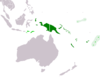
| show Authority control |
|---|
- Papua (province)
- Western New Guinea
- Provinces of Indonesia
- Arafura Sea
- New Guinea
- Autonomous provinces
- Ethnic conflicts in Indonesia
- States and territories established in 1969
- 1969 establishments in Indonesia