Los Angeles River
| Los Angeles River Spanish: Río de Los Ángeles | |
|---|---|
 Near Downtown Los Angeles | |
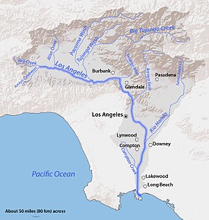 Map of the Los Angeles River watershed | |
| Location | |
| Country | United States |
| State | California |
| Cities | Burbank, Glendale, Los Angeles, Downey, Compton, Long Beach |
| Physical characteristics | |
| Source | Confluence of Bell Creek and Arroyo Calabasas |
| • location | Canoga Park, San Fernando Valley |
| • coordinates | 34°11′43″N 118°36′08″W / 34.19528°N 118.60222°W[1] |
| • elevation | 794 ft (242 m) |
| Mouth | Pacific Ocean |
• location | Los Angeles Harbor, Long Beach |
• coordinates | 33°45′23″N 118°11′20″W / 33.75639°N 118.18889°WCoordinates: 33°45′23″N 118°11′20″W / 33.75639°N 118.18889°W[1] |
• elevation | 0 ft (0 m) |
| Length | 47.9 mi (77.1 km)[2] |
| Basin size | 827 sq mi (2,140 km2)[3] |
| Discharge | |
| • location | Long Beach[3] |
| • average | 226 cu ft/s (6.4 m3/s)[3] |
| • minimum | 2 cu ft/s (0.057 m3/s) |
| • maximum | 129,000 cu ft/s (3,700 m3/s) |
| Basin features | |
| Tributaries | |
| • left | Bell Creek, Browns Canyon Wash, Aliso Creek, Tujunga Wash, Verdugo Wash, Arroyo Seco, Rio Hondo |
| • right | Arroyo Calabasas, Compton Creek |

The Los Angeles River (Spanish: Río de Los Ángeles), historically known as the Porciúncula River (Río Porciúncula), is a major river in Los Angeles County, California. Its headwaters are in the Simi Hills and Santa Susana Mountains, and it flows nearly 51 miles (82 km) from Canoga Park through the San Fernando Valley, Downtown Los Angeles, and the Gateway Cities to its mouth in Long Beach, where it flows into San Pedro Bay. While the river was once free-flowing and frequently flooding, forming alluvial flood plains along its banks, it is currently notable for flowing through a concrete channel on a fixed course, which was built after a series of devastating floods in the early 20th century.
Before the opening of the Los Angeles Aqueduct, the river was the primary source of fresh water for the city. Although the Los Angeles region still receives some water from the river and other local sources, most of the water supply flows from several aqueducts serving the area. The Los Angeles River is heavily polluted from agricultural and urban runoff.
Fed primarily by rainwater and snowmelt (in winter and spring), the Donald C. Tillman Water Reclamation Plant in Van Nuys (in summer and fall), and urban discharge, it is one of the few low-elevation perennial rivers in Southern California. Some water usually reaches the ocean, even in the driest summers; although there are historical accounts of the river running dry, there has been constant flow of the river every month since recording of stream flow began in 1929.[3] This is helped by the concrete channel, which limits absorption of water into the earth. Flow, while generally low in volume, can be extremely brisk even in summer.
Course[]


The Los Angeles River's official beginning is at the confluence of two channelized streams – Bell Creek and Arroyo Calabasas – in the Canoga Park section of the city of Los Angeles, just east of California State Route 27, at 34°11′43″N 118°36′07″W / 34.1952°N 118.601838°W (the east side of Canoga Park High School). Bell Creek flows east from the Simi Hills, and Arroyo Calabasas flows north from the Santa Monica Mountains. From there the river flows east through a concrete flood control channel and very soon receives Browns Canyon Wash, which flows south from the Santa Susana Mountains. The river then bends slightly south and receives Aliso Canyon Wash, whose watershed adjoins that of Browns Canyon. The river then flows through the district of Winnetka, then Reseda and enters the Sepulveda Basin, a flood-control reservoir formed by the Sepulveda Dam.[4][5][6][7]

As the river proceeds into the usually-dry reservoir, it spills out into a channel that is similar to its historical, non-channeled form. It crosses under Balboa Boulevard and then receives Bull Creek. The river then passes through the outlet works of Sepulveda Dam, 43 miles (69 km) from the mouth. It flows again into a concrete channel and crosses under Interstate 405 as it passes through Van Nuys, Sherman Oaks, and Studio City, still flowing east. Paralleling U.S. Highway 101 briefly, it then veers southeast, away from the highway, and receives from the left the Tujunga Wash, one of its largest tributaries, which flows southwest and south from the Angeles National Forest in the San Gabriel Mountains. The river then rounds a bend to the northeast, now in a concrete box culvert, and crosses under State Route 170 and Highway 101, and receives Burbank Western Channel on the left bank, 39 miles (63 km) from the mouth.[4][5][8][9]

The river then begins to parallel California State Route 134 as it winds through North Hollywood and the city of Burbank. It then crosses under Interstate 5 and makes a sharp bend to the south-southeast as it curves around Griffith Park. It receives from the left Verdugo Wash, which drains much of La Cañada Flintridge and Glendale as it flows from the San Gabriel Mountains south through a water gap in the Verdugo Mountains, and crosses under State Route 134. Here, the river begins to flow over a natural riverbed, but enters another concrete section soon after. Paralleling Interstate 5 for the next few miles, the river runs by the eastern side of Griffith Park and the Harding-Wilson Golf Course. It passes Silver Lake Reservoir, which is to the right, and crosses under California State Route 2, 32 miles (51 km) from the mouth.[4][5][10][11][12]

Making two meanders as it flows in a southeasterly direction, the river parallels the interstate and Riverside Drive then crosses under the interstate and California State Route 110 as it flows east of Elysian Park. It then receives the Arroyo Seco, another major tributary, from the left. The river flows south past the Mission Junction, a large railroad yard on the left. It enters a wider concrete channel with sloped sides, and crosses under Cesar Chavez Avenue, Highway 101, and Interstate 10 as it passes east of downtown Los Angeles, flowing past the East Los Angeles Interchange for Highway 101, California State Route 60, and Interstates 5 and 10 on the left. It then makes a gradual turn east and then turns southeast, flowing a few miles before it begins to parallel Interstate 710 near Maywood, Bell, Cudahy, and Commerce, 20 miles (32 km) from the mouth.[4][5][12][13]

Paralleling Interstate 710 south-southwest, the river then crosses under former California State Route 42 and the interstate as it receives the Rio Hondo from the left, 9 miles (14 km) from the mouth. The Rio Hondo ("deep river") now serves as a distributary for the San Gabriel River to the east via the Whittier Narrows Reservoir. The river then crosses under I-105 and shifts slightly southwest, then flows east of Compton and west of Bellflower. After crossing under California State Route 91, it receives Compton Creek from the right, 2.7 miles (4.3 km) from the mouth. After crossing under Interstate 405 for the second time, 2 miles (3.2 km) from the mouth, it draws close to the Dominguez Channel to the west and flows due south to its outlet in Long Beach, under Interstate 710, past the RMS Queen Mary, and into the Port of Long Beach.[4][5][12][14][15]
History[]

The river provided a source of water and food for the Tongva people prior to the arrival of the Spanish.[16] After the establishment of Mission San Gabriel in 1771, the Spanish would refer to all of the Tongva living in that mission's vicinity as Gabrieleño. The Tongva were hunters and gatherers who lived primarily off fish, small mammals, and the acorns from the abundant oak trees along the river's path. There were at least 45 Tongva villages located near the Los Angeles River, concentrated in the San Fernando Valley and the Elysian Valley, in what is present day Glendale.
In 1769, members of the Portolá expedition to explore Alta California were the first Europeans to see the river. On August 15, the party camped near the river, somewhere along the stretch just to the north of the Interstate 10 crossing near downtown Los Angeles. Fray Juan Crespi, one of two Franciscan missionaries traveling with Portolá, named it el río de Nuestra Señora La Reina de Los Ángeles de Porciúncula. Crespi chose that name, because August 15 is the date of the yearly Catholic feast day in honor of the Virgin Mary's Assumption into Heaven and assuming the role as Queen of the Angels, to which the small Portiuncula chapel, where the Franciscan Order began in Assisi, Italy, is dedicated. The river was thereafter referred to as the "Porciuncula River". In later years, the "Los Angeles" part of Crespi's lengthy name won out.[17]

The river was originally an alluvial river that ran freely across a flood plain that is now occupied by Los Angeles, Long Beach, and other townships in Southern California. Its path was unstable and unpredictable, and the mouth of the river moved frequently from one place to another between Long Beach and Ballona Creek. In the early 19th century, the river turned southwest after leaving the Glendale Narrows, where it joined Ballona Creek and discharged into Santa Monica Bay in present Marina del Rey. However, this account is challenged by Col. J. J. Warner, in his Historical Sketch of Los Angeles County:
"...until 1825 it was seldom, if in any year, that the river discharged even during the rainy season its waters into the sea. Instead of having a river way to the sea, the waters spread over the country, filling the depressions in the surface and forming lakes, ponds and marshes. The river water, if any, that reached the ocean drained off from the land at so many places, and in such small volumes, that no channel existed until the flood of 1825, which, by cutting a river way to tide water, drained the marsh land and caused the forests to disappear."[18]
Prior to the Great Flood of 1862, it was joined by the San Gabriel River in present-day Long Beach, but in that year the San Gabriel carved out a new course 6 miles (9.7 km) to the east, and has discharged into Alamitos Bay ever since.
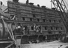
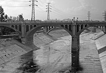
Until the opening of the Los Angeles Aqueduct in 1913, the Los Angeles River was the primary water source for the Los Angeles Basin, but much of its channel had extremely low discharge except during the winter rains.[citation needed] Unpredictable and devastating floods continued to plague it well into the 1930s (the most notable one being the catastrophic 1938 flood that precipitated the recall of then-mayor of Los Angeles Frank L. Shaw), leading to calls for flood control measures. The Army Corps of Engineers duly began an ambitious project of completely encasing the river's bed and banks in concrete, with only a trickle of water usually flowing down its middle.[citation needed] The only portions of the river that are not completely paved over are in the flood-control basin behind the Sepulveda Dam near Van Nuys; an 11-mile (17.7-km) stretch east of Griffith Park known as the Glendale Narrows; and along its last few miles in Long Beach.[citation needed]
The river was dry for nine months of the year as late as the 1950s. According to an August 2013 article in the Los Angeles Times, the water in the river today is largely "industrial and residential discharge," which originates from the "two giant pipes that collect the sewage from the homes of 800,000 San Fernando Valley residents" that lead to the Tillman Water Reclamation Plant, "before crashing over a man-made waterfall into Lake Balboa. That body of water, along with two smaller ones, puts 23 million gallons of water a day into the river at Sepulveda Basin."[19]
Points of interest[]
Sepulveda Basin is a flood-control basin to manage floodwater runoff. Except for infrequent but dramatic flood episodes, this dry-land flood control basin, most of which is leased from the Corps by the City of Los Angeles Department of Recreation and Parks, plays host to diverse uses today including athletic fields, agriculture, golf courses, a fishing lake, parklands, a sewage treatment facility, and a wildlife reserve.[20]
The Los Angeles River bicycle path runs through the Glendale Narrows and is accessible to the public at its north end at Riverside Drive, at Los Feliz Boulevard, and at its south end at Glendale Boulevard, Fletcher Drive and at Egret Park in Elysian Valley.[21][22] The bike path runs parallel to the 5 freeway for the majority of its length and has mile markers and call boxes for information and safety purposes.
Rio de Los Angeles State Park is north of downtown Los Angeles in the neighborhood of Cypress Park on the east bank of the river. The 247-acre (1.00 km2) park includes restored wetlands featuring native plants as well as recreational activities.[23]
The river's southern stretch forms the heart of an industrial corridor, stretching nearly unbroken from Lincoln Heights to Long Beach. In this area, the busy Long Beach Freeway (I-710) and several high-voltage power lines run within a few hundred feet of the riverbed. Several rail yards are located along the river's banks in this stretch, as well.[citation needed] Just outside the industrial corridor lie some of the most densely populated cities in the state of California, such as the cities of Bell, Bell Gardens, Cudahy, Maywood and South Gate; most of these cities are in the river's flood plain and experienced significant flooding prior to channelization.[citation needed]
Wildlife[]

Historically, the native species of fish in the Los Angeles River included rainbow/steelhead trout (Oncorhynchus mykiss), river shrimp, Chinook salmon (Oncorhynchus tshawytscha), Sacramento pikeminnow (Ptychocheilus grandis), Pacific lamprey, three-spined stickleback, and Santa Ana sucker. In 1877 Archduke Ludwig Salvator of Austria published a book about his 1876 visit to Los Angeles, entitled Los Angeles in Südcalifornien. Eine Blume aus dem goldenen Land (Los Angeles in Southern California. A Flower from the Golden Land) which included a description of the fish in the Los Angeles River: "“the salmon, Quinnat salmon (Salmo quinnat), abundant between November and June; two kinds of trout, the brook trout (Salar iridea); and the salmon trout (Ptychocheilus grandis).” These three species are known today as the Chinook salmon, steelhead/rainbow trout, and Sacramento pikeminnow.[24] The native species of the Los Angeles River were extirpated by the conversion of the natural riverbed into a concrete trapezoidal channel in 1938. The last known native species to be caught in the river was a rainbow trout in 1940 by a local fisherman.[25]
There is an abundance today of non-native fish species in the Los Angeles River which include common carp, largemouth bass, tilapia, green sunfish, Amazon sailfin catfish, bluegill, black bullhead, brown bullhead, channel catfish, fathead minnow, crayfish, and mosquito fish. However, Arroyo chub, which was once thought gone since the channelization has made small appearances throughout parts of the Los Angeles River, Most recent being in the area of Balboa Lake/Anthony C. Beilenson Park in the surrounding channels such as Bull Creek, Woodley Creek and around the creeks and main body of the Sepulveda Basin Wildlife Reserve.
There is also a large variety of bird species in the Los Angeles River which include snowy egret,[26] great egret[27] black-necked stilt,[26] great blue heron,[26][27] green heron,[26] mallard,[26] cinnamon teal,[26] American coot,[26][27] Muscovy duck,[26] white pelican, Canada goose, osprey, California high desert mourning dove, black-chinned hummingbird, barn owl, and red tailed hawk.[27] All of these species either nest or live off of the resources of the river. Before the river's channelization the river supported a variety of mammals which included the California golden bear (removed 1897), grey wolf (removed 1890s), coyote, mule deer, and North American beaver.
There is indirect evidence that North American beaver (Castor canadensis) were native to the river, as the Beñemé (Mojave) and Jeniguechi (San Jacinto branch of the Cahuilla) Indians of the San Gabriel Mission were described by Father Pedro Font on the second de Anza Expedition in 1776, "The costume of the men in heathendom is total nakedness, while the women wear a bit of deer skin with which they cover themselves, and likewise an occasional cloak of beaver or rabbit skin, although the fathers endeavor to clothe the converted Indians with something as best they can."[28] The Tongva or Gabrieleño Indians of Mission San Gabriel had a word for beaver To-le-vah-che.[29]
Revitalization[]

The ongoing efforts to revitalize the river began in earnest in approximately 2002. A number of city and county departments, committees and non-profit organizations have led the revitalization efforts. Since the 1938 floods and the subsequent concreting of the river channel, actual restoration of the River to its natural state is no longer possible or necessarily desirable, in most of the 51 mile river, lest new flooding should occur.[30]
Studies in the 1980s included a freeway to be used during the dry season to alleviate traffic congestion, and use as a path for hovercraft.[31]
There have been countless projects to restore recreational use, including a 2.5 mile section of the Glendale Narrows that opened to the public for unrestricted recreational use between Memorial Day and Labor Day in 2013.[32] In May 2014 it was announced that two sections of the river would again be open for recreational use during the summer.[33][34]
The Los Angeles City Council formed an ad hoc committee in 2002 to focus on accessing and revitalizing the river that was chaired by Councilmember Ed Reyes.[35] The California Coastal Conservancy, a state agency, published its Los Angeles River Park and Recreation Study in 1993, identifying potential projects along the river. In 2006, Los Angeles Mayor Villaraigosa visited South Korea to look at their river restoration project for the Cheonggyecheon.[36]
As a result of the Ad Hoc River Committee's efforts, and with funding from the Los Angeles Department of Water and Power, the City of Los Angeles’ Department of Public Works - Bureau of Engineering issued a request for proposals in 2005 for the preparation of a Revitalization Master Plan, which would identify proposals that would make the Los Angeles River a "front door" to the City, and support civic activities. The city's Los Angeles River Revitalization Master Plan was adopted in 2007.
One of the key recommendations made by the master plan was the establishment of a non-profit development corporation, with a board appointed by the then Mayor Antonio Villaraigosa and certain members of L.A. City Council, to carry out many of its recommended projects. In September 2009, the first board meeting of the LA River Revitalization Corporation was held. Startup funding was provided by the CRA. Harry B. Chandler was elected first chair of the board, and Omar Brownson was hired in 2010 to be the founding Executive Director. The first development project undertaken by LARRC was creating a public-private partnership to create the first pedestrian, bike and equestrian bridge across the river. Developer Mort La Kretz provided the seed financing for the bridge, which was built next to the 5 freeway in the Elysian Valley by the Los Angeles Bureau of Engineering and completed in 2020.
On July 23, 2013, the LARRC announced a goal of completing a continuous 51-mile (82 km) greenway and bike path along the river by the end of the decade.[37][38] The path is envisioned to be the central focus of a linear recreational park as well as providing an alternative transportation path through Los Angeles.[39]
The Los Angeles Times first reported in 2015 that the renowned architect Frank Gehry was collaborating with the LARRC (whose name was changed to River LA).[40] In 2017, Gehry Partners and River LA produced an informational database on the River known as the LA River Index.[41]
In 2018, the County of Los Angeles opted to update their River Masterplan. Geosyntec was hired to lead the effort, with Gehry Partners, RiverLA and OLIN taking on additional responsibilities. In 2019, Gehry revealed to Alta Magazine that he is working on designing several projects along the River, including a cultural center in Southgate.[42]
On September 13, 2013, the Army Corps of Engineers recommended a $453 million plan to restore nearly 600 acres of wildlife habitat – much of that located between Griffith Park and Lincoln Heights – as the best option to restore the river's ecosystem while preserving the flood protection provided by the concrete encasement. Subsequently, all Federal funding for the plan has been on hold.[43] In early 2016, there was some dispute as to federal funding for river cleanup after winter storms.[44] As part of Proposition 68 in California in June 2018, later that year, grants were given for the cleanup of invasive plants along part of the river.[45] As a result, in 2018, Los Angeles and its LARiverWorks policy team had a project underway for "every mile of the river within city limits, aiming to improve connectivity, increase open space, and restore habitat. New bridges and trails will accommodate people on foot, bikes, or horseback."[46] Plans to cleanup 11 miles of river north of downtown Los Angeles, in the hopes of attracting steelhead trout, will cost $1.1 billion.[47] In February 2019, the Los Angeles County Flood Control District was informing the federal government that it wanted to take control of about 40 miles of channels owned by the U.S. Army Corps of Engineers.[48]
Friends of the Los Angeles River[]
Friends of the Los Angeles River (FoLAR) was founded in 1986 by poet and activist Lewis P. Macadams.[49] Originally deemed a "40-year artwork to bring the River back to life,"[50] FoLAR was the first organization advocating for habitat restoration and public access on the LA River.[50]
One FoLAR's more prominent ongoing projects is the annual Great LA River Cleanup, which began in 1988 with a group of less than twenty people. In 2017, the Great LA Cleanup had up to 10,000 volunteers over three weekends covering the upper, middle, and lower sections of the River. In 2016, an estimated 5,000 volunteers took place in the annual cleanup, including the mayor and several elected officials.[51] In 2018, more than 6,000 volunteers removed more than 60 tons of trash at nine sites along the Los Angeles River.[52] In 2019, the FoLAR cleanup was the largest river cleanup in the United States.[53] The cleanup marked 30 years in 2019.[52] By the summer of 2019, kayaking in Los Angeles in the river had become common.[54] As of 2018, FoLAR has adopted a year-round cleanup model through partnerships with other environmental organizations like Heal the Bay, and through service opportunities for corporate groups and large organizations through River Makers program.
In 2012, FoLAR raised a $1 million donation to support the completion of the by the United States Army Corps of Engineers (USACE).[55] This study ultimately resulted in the adoption of , a restoration plan focused on 719 acres of habitat and pedestrian-friendly improvements, among other things.[56][55][57]
Riverside communities[]
Communities and cities along the banks of the Los Angeles River include:
- Canoga Park
- Winnetka
- Reseda
- Encino
- Lake Balboa
- Van Nuys
- Sherman Oaks
- Studio City
- Universal City
- Toluca Lake
- Burbank
- Glendale
- Los Feliz
- Atwater Village
- Elysian Valley
- Glassell Park
- Cypress Park
- Chinatown
- Lincoln Heights
- Boyle Heights
- Vernon
- East Los Angeles
- South Central Los Angeles
- Maywood
- Commerce
- Bell
- Bell Gardens
- Cudahy
- South Gate
- Lynwood
- Paramount
- Compton
- Long Beach
Crossings[]
Entertainment setting[]
This section needs additional citations for verification. (November 2014) |
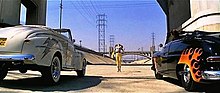
Numerous films, television programs, music videos, commercials and video games have featured various sites along the Los Angeles River (some as far as the Sepulveda Basin). Since the River is a trickle for much of the year and the culvert is dry, it is often used as a setting for races, car chases, gang rumbles, and other scenes requiring an open, deserted setting within the city.
The following have scenes filmed or set within the culvert:
- 24
- All Quiet On The Western Front
- Blood In Blood Out
- Blue Thunder
- Chinatown
- Cleopatra Jones
- Deadline Auto Theft
- Double Nickels
- Drive
- Earthquake
- Fear the Walking Dead
- Gangster Squad
- Girls Town
- Gleaming the Cube
- Gone in 60 Seconds and its loose remake
- Grease
- Harley Davidson and the Marlboro Man
- I Got The Hook Up
- In Time
- It's Alive
- L.A. Story
- Last Action Hero
- Point Blank
- Point Break
- Repo Man
- Terminator 2: Judgment Day
- The Adventures of Buckaroo Banzai Across the 8th Dimension
- The Core
- The Dark Knight Rises
- The Gumball Rally
- The Italian Job
- The Junkman
- Them!
- To Live and Die in L.A.
- Transformers
The river is featured in Visiting... with Huell Howser Episode 218.[58]
TV series highlighting the river include The Beverly Hillbillies, Knight Rider , CHiPs, Terminator: The Sarah Connor Chronicles, American Horror Story: Apocalypse, the fifteenth season of The Amazing Race, as well as the seventh, sixteenth season of Hell's Kitchen, and The Stranger. Music videos incorporating the location include Kanye West's "Jesus Walks," Maroon 5's "Wake Up Call,", Good Charlotte's "The River" and Cheryl's "Call My Name".
Video games include the racing game series Midnight Club with Midnight Club 2 and Midnight Club: Los Angeles and the action-adventure games Grand Theft Auto: San Andreas and Grand Theft Auto V (both of which feature depictions of the river within the fictional city of Los Santos).
The house used for exterior shots of Brady's home in the sitcom The Brady Bunch at 11222 North Dilling Street in North Hollywood, has the bank of the river as the edge of its backyard.
See also[]
References[]
- ^ Jump up to: a b "Los Angeles River". Geographic Names Information System. United States Geological Survey. 1981-01-19. Retrieved 2011-05-16.
- ^ U.S. Geological Survey. National Hydrography Dataset high-resolution flowline data. The National Map Archived 2012-03-29 at the Wayback Machine, accessed 2011-05-07
- ^ Jump up to: a b c d "USGS Gage #11103000 on the Los Angeles River at Long Beach, CA". National Water Information System. U.S. Geological Survey. 1929–1992. Archived from the original on 2015-12-08. Retrieved 2011-05-16.
- ^ Jump up to: a b c d e "Los Angeles River" (PDF). The Trust for Public Land. www.tpl.org. Archived from the original (PDF) on 2006-03-03. Retrieved 2009-08-20.
- ^ Jump up to: a b c d e Map of the Los Angeles River (Map). Cartography by NAVTEQ. Google Maps. 2009. Archived from the original on 2014-10-13. Retrieved 2009-08-20.
- ^ "Urbanization spreads into the watershed of the Los Angeles River". Urban Education Partnership. www.urbanedpartnership.org. Archived from the original on March 7, 2007. Retrieved 2009-08-20.
- ^ "Friends Of Vast Industrial Concrete Kafkaesque Structures – Page 1". Seriss Corporation. Archived from the original on 2009-03-21. Retrieved 2009-08-20.
- ^ "Sepulveda Basin and Dam". Urban Education Partnership. www.urbanedpartnership.org. Archived from the original on 2007-03-07. Retrieved 2009-08-20.
- ^ "Friends Of Vast Industrial Concrete Kafkaesque Structures – Page 3". Seriss Corporation. Archived from the original on 2009-03-21. Retrieved 2009-08-20.
- ^ "The Verdugo Wash Converges with the Los Angeles River". Urban Education Partnership. www.urbanedpartnership.org. Archived from the original on 2007-03-06. Retrieved 2009-08-20.
- ^ "The Los Feliz Area of the Los Angeles River". Urban Education Partnership. www.urbanedpartnership.org. Archived from the original on 2007-01-02. Retrieved 2009-08-20.
- ^ Jump up to: a b c "Friends Of Vast Industrial Concrete Kafkaesque Structures – Page 4". Seriss Corporation. Archived from the original on 2009-03-21. Retrieved 2009-08-20.
- ^ "The Arroyo Seco Converges with the Los Angeles River". Urban Education Partnership. www.urbanedpartnership.org. Archived from the original on 2007-03-07. Retrieved 2009-08-20.
- ^ "The Rio Hondo Converges with the Los Angeles River". Urban Education Partnership. www.urbanedpartnership.org. Archived from the original on 2007-03-07. Retrieved 2009-08-20.
- ^ "Long Beach and the Mouth of the Los Angeles River". Urban Education Partnership. Archived from the original on 2007-03-07. Retrieved 2009-08-20.
- ^ Joe Linton (14 October 2005). Down By the Los Angeles River: Friends of the Los Angeles Rivers Official Guide. Wilderness Press. p. 5. ISBN 978-0-89997-391-3. Archived from the original on 4 July 2014. Retrieved 7 August 2012.
- ^ Bolton, Herbert E. (1927). Fray Juan Crespi: Missionary Explorer on the Pacific Coast, 1769–1774. HathiTrust Digital Library. pp. 146–147. Archived from the original on 2014-03-22. Retrieved 6 April 2014.
- ^ "Full text of "A history of California and an extended history of its southern coast counties, also containing biographies of well-known citizens of the past and present"". archive.org. Archived from the original on 2016-04-07. Retrieved 2015-07-10.
- ^ Smith, Doug (2003-08-14). "Angelenos' vision of their river is created from a made-up memory. Historically, the river has been dry for most of the year. Now, it flows continually, but most of the water in the channel is industrial and residential discharge". Retrieved 2013-08-16.
- ^ "Sepulveda Basin Wildlife Reserve". City of Los Angeles Department of Recreation and Parks. Archived from the original on November 20, 2015. Retrieved November 19, 2015.
- ^ "Bicycling – Glendale Narrows / Elysian Valley Bike Path". google.com. Retrieved October 25, 2015.
- ^ "Glendale Narrow and Elysian Valley Path". KCET. Archived from the original on October 17, 2015. Retrieved October 25, 2015.
- ^ Bustillo, Miguel (August 14, 2003) "Accord Brings Soccer Fields to Urban Park" Archived 2016-03-06 at the Wayback Machine Los Angeles Times
- ^ Ludwig Salvator, Marguerite Eyer Wilbur (1929). Los Angeles in the Sunny Seventies. A Flower from the Golden Land. B. McCallister, J. Zeitlin. p. 188.CS1 maint: uses authors parameter (link)
- ^ Sahagún, Louis (2020-10-05). "Steelhead trout in the L.A. River? These experts envision a fish passage through downtown". Los Angeles Times. Retrieved 2020-10-06.
- ^ Jump up to: a b c d e f g h "River Wildlife". Friends of the Los Angeles River. Archived from the original on July 14, 2015. Retrieved October 25, 2015.
- ^ Jump up to: a b c d Linton, Joe (October 14, 2005). Down By the Los Angeles River: Friends of the Los Angeles Rivers Official Guide. Wilderness Press. p. 42. ISBN 978-0-89997-391-3. Archived from the original on June 29, 2016. Retrieved October 25, 2015.
- ^ Pedro Font (1776). Expanded Diary of Pedro Font. Archived from the original on 2011-07-17. Retrieved 2011-01-30.
- ^ William McCawley (1996). The First Angelinos: The Gabrielino Indians of Los Angeles. Ballena Press. p. 304. ISBN 978-0965101608.
- ^ Sahagún, Louis (2021-01-11). "Frank Gehry's bold plan to upgrade the L.A. River seeks to atone for past injustices". Los Angeles Times. Retrieved 2021-01-14.
“We studied the river upside and down and found that less than 2% of the time it runs very fast and is very dangerous,” he said. “So, we thought if we can’t get rid of the concrete, maybe we can cover it."
- ^ GRAD, SHELBY and SCOTT HARRISON The long, tortured journey to bring rail back to Los Angeles. Los Angeles Times, November 1, 2016
- ^ Martinez, Michael and Hannah Button. "At last, Los Angeles River opens to public recreation after 80 years". CNN. Cable News Network. Turner Broadcasting System, Inc. Archived from the original on 8 June 2013. Retrieved 2 June 2013.
- ^ "Los Angeles River Recreation Zone – Summer 2014". Los Angeles River Recreation Program. May 2014. Archived from the original on 2014-05-24.
- ^ "Corps opens recreational boating program at Sepulveda". US Army Corps of Engineers. 23 May 2014. Archived from the original on 2014-05-24.
- ^ "Milestones". Archived from the original on 2019-12-31. Retrieved 2019-12-31.
- ^ "Seoul's Stream a 'Vision' for L.A." Los Angeles Times. 2006-10-17. Archived from the original on 2016-03-09. Retrieved 2018-12-15.
- ^ Christopher Hawthorne (2013-07-23). "Ambitious goal for L.A. River: Continuous 51-mile path by 2020". Los Angeles Times. Archived from the original on 2013-07-25. Retrieved 2013-07-25.
- ^ "Frank Gehry's controversial L.A. River plan gets cautious, low-key rollout". Los Angeles Times. 2016-06-18. ISSN 0458-3035. Archived from the original on 2017-08-01. Retrieved 2017-07-27.
- ^ Christopher Hawthorne (2013-07-24). "L.A. River advocates wait for watershed Army Corps study". Los Angeles Times. Archived from the original on 2013-07-25. Retrieved 2013-07-25.
- ^ "Archived copy". Archived from the original on 2019-12-16. Retrieved 2019-12-31.CS1 maint: archived copy as title (link)
- ^ "Frank Gehry's controversial L.A. River plan gets cautious, low-key rollout". Los Angeles Times. 2016-06-18. ISSN 0458-3035. Archived from the original on 2017-08-01. Retrieved 2017-07-31.
- ^ "Archived copy". Archived from the original on 2019-12-31. Retrieved 2019-12-31.CS1 maint: archived copy as title (link)
- ^ "Army of Corps of Engineers backs $453 million plan to restore L.A. River". The Eastsider. 2013-09-13. Archived from the original on 2015-06-02. Retrieved 2015-06-02.
- ^ "Archived copy". Archived from the original on 2019-10-03. Retrieved 2019-10-03.CS1 maint: archived copy as title (link)
- ^ "Archived copy". Archived from the original on 2019-10-03. Retrieved 2019-10-03.CS1 maint: archived copy as title (link)
- ^ "Archived copy". Archived from the original on 2019-10-03. Retrieved 2019-10-03.CS1 maint: archived copy as title (link)
- ^ "Archived copy". Archived from the original on 2019-10-03. Retrieved 2019-10-03.CS1 maint: archived copy as title (link)
- ^ "Archived copy". Archived from the original on 2019-10-03. Retrieved 2019-10-03.CS1 maint: archived copy as title (link)
- ^ Sahagun, Louis. "Legacy projects take shape honoring Lewis MacAdams, poet and crusader for transforming Los Angeles River – Los Angeles Times". latimes.com. Archived from the original on 2018-10-26. Retrieved 2018-10-26.
- ^ Jump up to: a b "A Brief History of Public Art and the L.A. River". KCET. 2014-03-19. Archived from the original on 2018-10-26. Retrieved 2018-10-26.
- ^ "Archived copy". Archived from the original on 2019-10-03. Retrieved 2019-10-03.CS1 maint: archived copy as title (link)
- ^ Jump up to: a b Great L.A. River CleanUp marks 30 years. Park LaBrea news / Beverly Press, April 11, 2019
- ^ "Archived copy". Archived from the original on 2019-10-03. Retrieved 2019-10-03.CS1 maint: archived copy as title (link)
- ^ "Archived copy". Archived from the original on 2019-10-03. Retrieved 2019-10-03.CS1 maint: archived copy as title (link)
- ^ Jump up to: a b "folar.org | Alternative 20 and the ARBOR Study". folar.org. Archived from the original on 2018-10-26. Retrieved 2018-10-26.
- ^ "Feds Okay $1-Billion Los Angeles River Project". KCET. 2014-05-28. Archived from the original on 2018-10-26. Retrieved 2018-10-26.
- ^ "11 mile makeover of the LA River is moving right along". Curbed LA. Archived from the original on 2018-10-26. Retrieved 2018-10-26.
- ^ "L.A. River- Visiting (218) – Huell Howser Archives at Chapman University".
Further reading[]
- The Los Angeles River: Its Life, Death, and Possible Rebirth. Blake Gumprecht. Baltimore and London: Johns Hopkins University Press, 1999. ISBN 0-8018-6047-4.
- Eden by design: the 1930 Olmsted-Bartholomew plan for the Los Angeles region. Greg Hise & William Francis Deverell. Berkeley: University of California Press, 2000. ISBN 0-520-22414-0. ISBN 0-520-22415-9.
- Río L.A.: Tales from the Los Angeles River. Patt Morrison. Los Angeles: Angel City Press, 2001. ISBN 1-883318-24-6.
- Down By The Los Angeles River: Friends of the Los Angeles River's Official Guide Joe Linton. Berkeley: Wilderness Press, 2005. ISBN 0-89997-391-4.
- Hazardous Metropolis: Flooding and Urban Ecology in Los Angeles Jared Orsi. University of California Press, 2004. ISBN 0-520-23850-8.
External links[]
| Wikimedia Commons has media related to Los Angeles River. |
- William Deverell, Whitewashed Adobe: The Rise of Los Angeles and the Remaking of Its Mexican Past, University of California Press, Los Angeles, 2005, Page 102, "Map 2: Changing Courses of the Los Angeles River"
- The Los Angeles River Master Plan
- Los Angeles River Revitalization Master Plan and City Ad Hoc Committee
- The Los Angeles River Tour
- Los Angeles & San Gabriel Rivers Watershed Council
- The River Project
- F.O.L.A.R. Friends of the Los Angeles River
- Friends of the Sepulveda Basin, organization website
- lariverflyfishing River blog from a unique perspective
- lacreekfreak, Blog
- Friends Of Vast Industrial Concrete Kafkaesque Structures, a photo journal of photographs of the Los Angeles River flood control channel.
- The Los Angeles River Film, a 28-minute documentary film about the Los Angeles River including recent revitalization efforts.
- Saving the Los Angeles River, story about saving the river via boating and activism.
- KCET Departures interview with Joe Linton advocate of restoration and revitalization of the L.A. river.
- L.A. River Expeditions, a leading advocate for recreational-educational boating and public access rights on the L.A. River.
- Rock the Boat, an award-winning documentary film featuring the L.A. River and many environmental advocates.
- Environmental Protection Agency, their historic 2010 determination about protecting the entire L.A. River watershed.
- Time magazine article, featuring the 2012 Paddle the L.A. River pilot program.
- CNN article, on the paddling program.
- New York Times article, on the river being opened to recreational use.
- BBC broadcast, on canoeing to save the river.
- [1], video capture of the flamingo chase.

- Los Angeles River
- Rivers of Los Angeles County, California
- Rivers of Southern California
- Geography of Los Angeles
- Geography of the San Fernando Valley
- San Fernando Valley
- South Gate, California