Los Santos District
Los Santos District | |
|---|---|
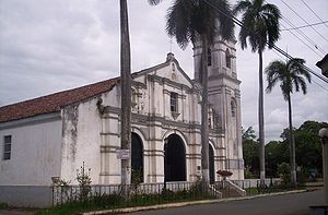 La Villa de los Santos | |
 Flag  Seal | |
 | |
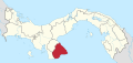
 Los Santos District Location of the district capital in Panama | |
| Coordinates: 7°50′N 80°20′W / 7.833°N 80.333°W | |
| Country | |
| Province | Los Santos Province |
| Capital | Las Tablas |
| Area | |
| • Total | 166 sq mi (429 km2) |
| Population (2000) | |
| • Total | 23,828 |
| Time zone | UTC-5 (ETZ) |

Los Santos District is a district (distrito) of Los Santos Province in Panama. The population according to the 2000 census was 23,828.[1] The district covers a total area of 429 km². The capital lies at the city of La Villa de los Santos.[1]
Administrative divisions[]
Los Santos District is divided administratively into the following corregimientos:
- La Villa de los Santos (capital)
- El Guásimo
- La Colorada
- La Espigadilla
- Las Cruces
- Las Guabas
- Los Angeles
- Los Olivos
- Llano Largo
- Sabanagrande
- Santa Ana
- Tres Quebradas
- Villa Lourdes
- Agua Buena
- El Ejido
References[]
- ^ a b "Districts of Panama". Statoids. Retrieved April 12, 2009.
| Bocas del Toro Province | |
|---|---|
| Chiriquí Province | |
| Coclé Province | |
| Colón Province | |
| Darién Province | |
| Herrera Province | |
| Los Santos Province | |
| Panamá Province | |
| Veraguas Province | |
| West Panamá Province | |
Coordinates: 7°50′N 80°20′W / 7.833°N 80.333°W
Categories:
- Districts of Panama
- Los Santos Province
- Los Santos Province geography stubs