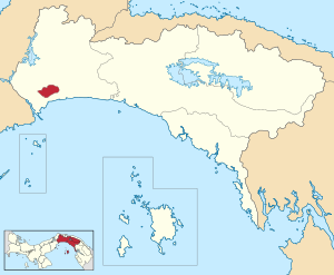
San Miguelito District
San Miguelito | |
|---|---|
 Flag | |
| Motto(s): “Tierra de la gente buena”(Spanish)
“Land of good people” | |
 | |
 San Miguelito Location of the district capital in Panama | |
| Coordinates: 9°2′N 79°30′W / 9.033°N 79.500°W | |
| Country | |
| Province | Panamá |
| Capital | City-District |
| Area | |
| • Total | 50.1 km2 (19.3 sq mi) |
| Population (2019) | |
| • Total | 375,409 |
| • Density | 7,500/km2 (19,000/sq mi) |
| official estimate[1] | |
| Time zone | UTC-5 (ETZ) |
San Miguelito is a city and district (distrito) of Panamá Province in Panama. The population according to the 2000 census was 293,745;[2] the latest official estimate (for 2019) is 375,409.[1] The district covers an area of 50.1 km². San Miguelito district is completely enclaved within Panama District (which completely surrounds it) and it is included in the Panama City Metropolitan Area.[2]
Football player Luis Tejada was born in San Miguelito, and both Blas Pérez and Kevin Kurányi were once residents of the district.
Administrative divisions[]
San Miguelito District is divided administratively into the following corregimientos:

Corregimientos of San Miguelito.
- Amelia Denis de Icaza
- Belisario Porras
- José Domingo Espinar
- Mateo Iturralde
- Victoriano Lorenzo
- Arnulfo Arias
- Belisario Frías
- Omar Torrijos
- Rufina Alfaro
Education[]
International School of Panama is located in San Miguelito.[3]
References[]
- ^ Jump up to: a b Instituto Nacional de Estadística y Censo, Panama.
- ^ Jump up to: a b "Districts of Panama". Statoids. Retrieved April 12, 2009.
- ^ "Contact Us." International School of Panama. Retrieved on September 20, 2015. "The International School of Panama Golf Club Road Cerro Viento Rural San Miguelito Panama City, Panama" - See map
Coordinates: 9°01′59″N 79°30′00″W / 9.033°N 79.500°W
Categories:
- San Miguelito District
- Panamá Province geography stubs

