Madungandí
Guna de Madungandí | |
|---|---|
 Flag | |
 | |
| Country | |
| Province | Panamá |
| District | Chepo |
| Established | January 12, 1996[1] |
| Area | |
| • Land | 2,075.9 km2 (801.5 sq mi) |
| Population (2010)[1] | |
| • Total | 4,271 |
| • Density | 2.1/km2 (5/sq mi) |
| Population density calculated based on land area. | |
| Time zone | UTC−5 (EST) |
Guna de Madungandí or Madungandí, formerly known as Kuna de Madugandí[2] is a comarca indígena (indigenous territory) and corregimiento in Chepo District, Panamá Province, Panama with a population of 4,271 as of 2010.[1] It was created by Law 24 of January 12, 1996.[1] Its population as of 2000 was 3,305.[1]
The primary ethnicity is Guna.
The comarca is not divided into districts; but is divided into 12 communities: Akua Yala, Ibedí, Pintupu, Icandí, Piria, Cuinupdi, Nargandí, Ogobnawila, Diwar Sikua, Capandi and Tabardi. Its capital is .
Its area is 2318.8 km2 and is located near the Bayano River.
References[]
- ^ a b c d e f "Cuadro 11 (Superficie, población y densidad de población en la República...)" [Table 11 (Area, population, and population density in the Republic...)] Archived 2016-03-04 at the Wayback Machine (.xls). In "Resultados Finales Básicos" [Basic Final Results] (in Spanish). National Institute of Statistics and Census of Panama. Archived from the original on July 10, 2015. Retrieved May 26, 2015.
- ^ "¿Guna, kuna o cuna?: James Howe | la Prensa Panamá". 22 February 2014.
Capital: Panama | ||
| Balboa District | 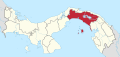 | |
| Chepo District | ||
| Chimán District | ||
| Panamá District | ||
| San Miguelito District | ||
| Taboga District | ||
Categories:
- Corregimientos of Panamá Province
- Kuna de Madugandí
- Comarcas of Panama
- States and territories established in 1996
- 1996 establishments in Panama
- Panamá Province geography stubs