Lough Dan
| Lough Dan | |
|---|---|
 Looking south-east | |
 Lough Dan | |
| Location | County Wicklow |
| Coordinates | 53°04′32″N 6°17′09″W / 53.075436°N 6.285918°WCoordinates: 53°04′32″N 6°17′09″W / 53.075436°N 6.285918°W |
| Native name | Loch Deán (Irish) |
| Primary inflows | , |
| Primary outflows | River Avonmore |
| Catchment area | 63.18 km2 (24.39 sq mi) |
| Basin countries | Ireland |
| Max. length | 3 km (1.9 mi) |
| Max. width | 0.5 km (0.31 mi) |
| Surface area | 1.03 km2 (0.40 sq mi) |
| Average depth | 13.5 m (44 ft) |
| Surface elevation | 200 m (660 ft) |
| Islands | none |
| References | [1] |

Lough Dan (Irish: Loch Deán)[2] is a scenic boomerang-shaped ribbon lake largely set on private property, in the Wicklow Mountains in Ireland. Lough Dan lake lies at the base of Luggala 595 metres (1,952 ft) and Knocknacloghoge 534 metres (1,752 ft) mountains. The lough is fed by the Cloghoge (draining Lough Tay), and Inchavore rivers, and is drained by the River Avonmore. Part of Lough Dan forms part of the Guinness Estate at Luggala, and has limited public access.[3][4]
Geography[]
The Inchavore river flows into Lough Dan from the north-west. An outflow from Lough Tay – the Cloghoge river – feeds it from the north-east. It is drained to the south by the River Avonmore. Most of the lake is surrounded by private lands, though the north-western corner is part of the Wicklow National Park.
Scouting[]
The Scouting Ireland S.A.I. national campsite, now one of several belonging to Scouting Ireland, lies beside the lake. In 1997, Lough Dan was the site of an Irish Scouting jamboree, Lough Dan '97, at the S.A.I. national campsite, co-organised by the Federation of Irish Scouts Associations. The Jamboree was abandoned on the Thursday due to inclement weather and flooding.
Gallery[]
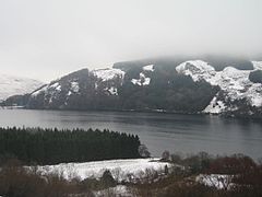
Snow around Lough Dan

Looking north from west bank

Looking south-east from west bank

Cloghoge River between Lough Tay and Lough Dan


See also[]
| Wikimedia Commons has media related to Lough Dan. |
References[]
- ^ "A Reference Based Typology and Ecological Assessment System for Irish Lakes" (PDF). Environmental Protection Agency (Ireland). 2006. p. 17. Retrieved 15 April 2020.
- ^ "Loch Deán/Lough Dan". Placenames Database of Ireland (logainm.ie). Department of Culture, Heritage and the Gaeltacht and Dublin City University. Retrieved 15 April 2020.
- ^ Lorna Siggins (10 August 2018). "State urged to buy 4,000 acres of Luggala estate for public use". Irish Times. Retrieved 12 July 2019.
- ^ Fairbairn, Helen (2014). Ireland's Best Walks: A Walking Guide. Collins Press. ISBN 978-1848892118.
Route 59: Luggala and Knocknacloghoge
External links[]
- Wicklow Mountains National Park page
- Irelandscape section on Lough Dan
- Mountain Views information about the Knocknacloghoge area
- Online climbing guide to Lough Dan site
This article related to the geography of County Wicklow, Ireland is a stub. You can help Wikipedia by . |
- Lakes of County Wicklow
- Campsites of Scouting Ireland
- County Wicklow geography stubs