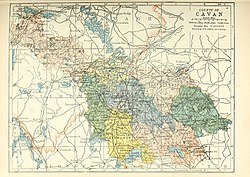
Loughtee Lower
Loughtee Lower
Lucht Tí Íochtarach (Irish) | |
|---|---|
Barony | |
 Centre of Milltown, County Cavan | |
 Barony map of County Cavan, 1900; Loughtee Lower is in the north, coloured pale yellow. | |
| Sovereign state | Republic of Ireland |
| Province | Ulster |
| County | Cavan |
| Area | |
| • Total | 114.28 km2 (44.13 sq mi) |
Loughtee Lower (Irish: Lucht Tí Íochtarach), or Lower Loughtee, is a barony in County Cavan, Republic of Ireland.[1][2][3] Baronies were mainly cadastral rather than administrative units.[4] They acquired modest local taxation and spending functions in the 19th century before being superseded by the Local Government (Ireland) Act 1898.[5]
Etymology[]
Loughtee Lower takes its name from the Irish Lucht Tí, Early Modern Irish lucht tighe Még Mathghamhna (Annals of the Four Masters), "people of the household of Mac Mahon"; presumably the land was allocated to the vassals of the McMahon tribe.[6][7][8]
Geography[]
Loughtee Lower is located in the north of County Cavan, on the River Erne and south of the Woodford River.[9]
History[]

The Ó Faircheallaigh (Farrelly) and MacGaghrans (Magaherans) were ruling Gaelic Irish tribes in the area; they were hereditary coarbs and erenachs of , located near here.[10]
The barony of Loughtee was created by 1609 in the Plantation of Ulster, and was archaically spelled Loughty.[11] Its alluvial soil was recognised as the best in Cavan, and it was originally allocated to the Crown, then later to undertakers.[12]
It was split into Lower and Upper parts in 1821.[13]
List of settlements[]
Below is a list of settlements in Loughtee Lower:
References[]
- ^ "The Parliamentary Gazetteer of Ireland: Adapted to the New Poor-law, Franchise, Municipal and Ecclesiastical Arrangements, and Compiled with a Special Reference to the Lines of Railroad and Canal Communication, as Existing in 1814-45". A. Fullarton and Company. 5 March 1846 – via Google Books.
- ^ Commons, Great Britain Parliament House of (5 March 1876). "Accounts and Papers of the House of Commons". Ordered to be printed – via Google Books.
- ^ "Drumlane - Topographical Dictionary of Ireland (1837)". www.libraryireland.com.
- ^ "Griffith Lodge, ARTONAGH (LOWER LOUGHTEE BY.), CAVAN". Buildings of Ireland.
- ^ General Register Office of Ireland (1904). "Alphabetical index to the baronies of Ireland". Census of Ireland 1901: General topographical index. Command papers. Cd. 2071. HMSO. pp. 966–978.
- ^ "Lucht Tí Íochtarach/Loughtee Lower". Logainm.ie.
- ^ "Part 3 of Annals of the Four Masters". celt.ucc.ie.
- ^ "Part 3 of Annals of the Four Masters". celt.ucc.ie.
- ^ http://www.public-library.uk/dailyebook/Atlas%20and%20cyclopedia%20of%20Ireland%20Volume%201%20(1905).pdf
- ^ "The Baronies of Ireland - History". sites.rootsweb.com.
- ^ https://catalog.hathitrust.org/Record/100680118
- ^ http://mural.maynoothuniversity.ie/1627/1/PDuffyCavan.pdf
- ^ "Census 1821 - County Cavan, IrelandGenWeb". sites.google.com.
- Baronies of County Cavan
