Lovat (river)
| Lovat | |
|---|---|
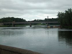 Lovat in Velikiye Luki | |
| Location | |
| Country | Belarus, Russia |
| Physical characteristics | |
| Source | |
| • location | |
| Mouth | Lake Ilmen |
• coordinates | 58°12′42″N 31°26′40″E / 58.21167°N 31.44444°ECoordinates: 58°12′42″N 31°26′40″E / 58.21167°N 31.44444°E |
| Length | 530 kilometres (330 mi)[1] |
| Basin size | 21,900 square kilometres (8,500 sq mi)[1] |
| Discharge | |
| • average | 105 cubic metres per second (3,700 cu ft/s)[1] |
| Basin features | |
| Progression | Lake Ilmen→ Volkhov→ Lake Ladoga→ Neva→ Gulf of Finland |

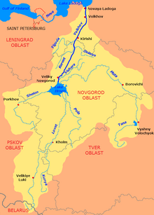
The Lovat (Belarusian: Ловаць Łovać, pronounced [ˈɫovatsʲ]; Russian: река́ Ло́вать) is a river in Vitebsk Oblast of Belarus, Usvyatsky, Velikoluksky, and Loknyansky Districts, as well as of the city of Velikiye Luki, of Pskov Oblast and Kholmsky, Poddorsky, Starorussky, and Parfinsky Districts of Novgorod Oblast in Russia. The source of the Lovat is in northeastern Belarus, and the Lovat is a tributary of Lake Ilmen. Its main tributaries are the Loknya (left), the Kunya (right), the Polist (left), the Redya (left), and the (right). The towns of Velikiye Luki and Kholm, as well as the urban-type settlement of Parfino, are located on the banks of the Lovat.
From the source, the Lovat flows in the southeastern direction along the border between Russia and Belarus, it turns north and enters Pskov Oblast of Russia, crossing the border as . In this area, the Lowat flows through the lake district, passing, in particular, . Downstrean of Velikiye Luki, in the selo of Podberezye, the Lovat turns northwest and enters Novgorod Oblast. Close to Lake Ilmen, the Lovat shares a river delta with the Pola and the Polist, though technically Polist is counted as a tributary of the Lovat.
The river basin of the Lovat comprises vast areas in the south of Novgorod and Pskov Oblasts, as well as some areas in Tver Oblast and Vitebsk Oblast of Belarus.
The Lovat is listed in the State Water Register of Russia as navigable between Parfino and the mouth, however, there is no passenger navigation. Until the 1990s, it was used for timber rafting.[1]
The Lovat served as a stretch of the trade route from the Varangians to the Greeks, the most important trading route of medieval Rus. From Lake Ilmen, ships went upstream the Lovat and then the Kunya, before ending up in the Western Dvina.They then travelled up the Kasplya river to Lake Kasplya from where they crossed the portage to the Dnieper, from where they could reach Constantinople via the Black Sea.[2]
References[]
External links[]
![]() Media related to Lovat River at Wikimedia Commons
Media related to Lovat River at Wikimedia Commons
- Река Ловать (in Russian). State Water Register of Russia. Retrieved 23 February 2012.
- Tributaries of Lake Ilmen
- Rivers of Novgorod Oblast
- Rivers of Pskov Oblast
- Rivers of Vitebsk Region
- International rivers of Europe
- Rivers of Belarus