Loyalist, Ontario
Loyalist | |
|---|---|
Township municipality (lower-tier) | |
| Township of Loyalist | |
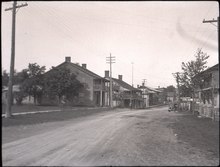
 Main street in Bath | |
| Motto(s): "A Loyal Three Made Stronger In One" | |
 Loyalist | |
| Coordinates: 44°14′37″N 76°46′09″W / 44.24361°N 76.76917°W[1]Coordinates: 44°14′37″N 76°46′09″W / 44.24361°N 76.76917°W[1] | |
| Country | Canada |
| Province | Ontario |
| County | Lennox and Addington |
| Formed | January 1, 1998 |
| Government | |
| • Type | Township |
| • Mayor | Ric Bresee |
| • Federal riding | Lanark—Frontenac—Lennox and Addington |
| • Prov. riding | Lanark—Frontenac—Lennox and Addington |
| Area | |
| • Land | 341.02 km2 (131.67 sq mi) |
| Population (2016)[2] | |
| • Total | 16,971 |
| • Density | 49.8/km2 (129/sq mi) |
| Time zone | UTC-5 (EST) |
| • Summer (DST) | UTC-4 (EDT) |
| Postal Code | K0H |
| Area codes | 613, 343 |
| Website | www |

Loyalist is a lower-tier township municipality in central eastern Ontario, Canada on Lake Ontario. It is in Lennox and Addington County and consists of two parts: the mainland and Amherst Island. It was named for the United Empire Loyalists, who settled in the area after the American Revolution.
Loyalist Township was formed on January 1, 1998, through the amalgamation of Amherst Island Township, Ernestown Township, and Bath Village.
Communities[]
The primary centres of settlement in Loyalist are Amherstview, Bath and Odessa. Smaller communities include Asselstine, Bayview, Emerald, Ernestown, Links Mills, McIntyre, Millhaven, Morven, Nicholsons Point, Stella, Storms Corners, Switzerville, Thorpe, Violet and Wilton. Since Loyalist Township is the only municipal level of government in the area, the boundaries of most settlements are unofficial and matters of tradition.
Amherstview[]
Amherstview is named for Amherst Island, located directly to the south in Lake Ontario. When the community was first established in the 1950s, the spelling was generally "Amherst View". The community is the eastern end of the Loyalist Parkway, a stretch of Highway 33 that travels along Lake Ontario, in an area in which many United Empire Loyalists settled. As of 2021, Amherstview has a population of about 6500.[3]
Amherstview is home to Fairfield House which is situated in Fairfield Park on the shore of Lake Ontario. Fairfield House was constructed in 1793 by the Fairfield family who were among the first Loyalists to settle the area. It served as the family home and a portion of the building was also used as a tavern for some time. The wood and limestone building is now a museum exhibiting period artifacts and furniture and offering guided tours.
Fairfield Park itself stretches along more than 600 m of Lake Ontario shoreline. The park is a popular picnicking area and is also well used by swimmers and scuba divers. Limestone shelf rock formations leading into the water simplify the launching and landing of kayaks and canoes although suitable facilities for larger watercraft do not exist. The park is home to many species of trees including red oak, poplar, willow, shagbark hickory, ash, maple, cedar, linden, and spruce. Extensive banks of lilac provide flowers and fragrance in season and many of the larger trees in the park are fitted with strings of lights for display at Christmas.
Amherstview is also home to the Henderson Recreation Centre. The centre houses a public library, a 25 m public swimming pool, and an arena and also includes an outdoor soccer field. The arena is the home rink for the Amherstview Jets hockey team.
Bath[]

Bath was first settled by the United Empire Loyalists in 1784, making it one of the oldest communities in Ontario. It was served by an early colonial road, the 1784 Bath Road, which follows the lakefront as the Loyalist Parkway. Discharged soldiers from Jessup's Rangers were the first settlers. The economic development of the community was enabled by a sheltered harbour and road connections with Kingston stimulated economic development. By mid-century Bath was a prosperous point of trade.[4] After the town had been divided up between the families of Hawley, Davy, Rose and Amey, it was John Davy who was first to lay down roads on his lot #10. By 1804 the whole village had been prepared for settlement and surveyed. The village was originally named Ernestown, but was renamed Bath in 1819 after the city in England.
A bustling lakefront manufacturing village with 400-1000 people in the 1850s, Bath began to lose industrial importance to Napanee (and to cities like Kingston/Belleville) after being successively bypassed by the York Road (1817), the Grand Trunk Railway (1856) and the 401 motorway (1964). The closest rail access was an 1856 Ernestown rail station built to the west of Camden East Road in a rural area, similar in design to Napanee's historic station; it is now boarded up and inaccessible.[5]
The village was incorporated in 1859 and disincorporated by its 1998 annexation to Loyalist Township. Bath is directly west of Millhaven, the location of Millhaven Institution. Loyalist Golf and Country Club is a golf course in Bath. Every year on July 1 there is a Canada Day celebration featuring a parade and fair. Bath is home to the medium security prison Bath Institution, which is co-located within the Millhaven Institution.
The small town of Bath as of 2016 has a population of 2154. This is an increase of 10.1% from 2011 when they had a population of 1957.
Odessa[]

Odessa, originally named Millcreek, was renamed in 1855 by its postmaster to commemorate the 1854 British siege of the Black Sea port at Odessa in Ukraine during the Crimean War.[6] The village is home to Ernestown Secondary School, which services about 650 students from Loyalist Township (formerly Ernestown Township), Napanee and Stone Mills. The township offices and a fire hall are on Odessa's Main Street. There is a small fairground. An Ontario Provincial Police detachment serves Ontario Highway 401 and is home to the Tactics and Rescue Unit Eastern Region.
The water supply of the community of Odessa within the Township of Ernestown was studied in 1972,[7] which led to the planning of infrastructure improvements. The highest point in the village is the water tower. Visible for several kilometres in all directions, the water tower has been outfitted as a wireless communications facility. The village bills itself as "home of the Babcock Mill," which historically was powered by Millhaven Creek which runs through the heart of Odessa.
Amherst Island (formally Amherst Island Township)[]

Stella and Emerald are located on Amherst Island. Stella is the major hamlet, where the ferry docks are, and lends its name as the postal outlet name for Amherst Island. Emerald is a collection of 4 houses and a church toward the west end of the Island. Amherst Island is located about 3 kilometres (1.9 mi) offshore from the rest of Loyalist Township, and is serviced by an automobile and truck ferry from Millhaven. Amherst Island was farmed for generations by Irish tenants who rented from a Lord through his manager, and many residents are descendants of those early settlers. Today it has a small arts community, a number of volunteer civic groups, and a radio station, CJAI-FM, that add to the island's special flavour.
Demographics[]
| 2016 | 2011 | 2006 | |
|---|---|---|---|
| Population | 16,971 (+4.6% from 2011) | 16,221 (+7.7% from 2006) | 15,062 (+3.2% from 2001) |
| Land area | 341.02 km2 (131.67 sq mi) | 341.04 km2 (131.68 sq mi) | 340.02 km2 (131.28 sq mi) |
| Population density | 49.8/km2 (129/sq mi) | 47.6/km2 (123/sq mi) | 44.3/km2 (115/sq mi) |
| Median age | 45.0 (M: 44.0, F: 46.1) | 43.6 (M: 42.4, F: 45.0) | 42.7 (M: 42.2, F: 43.1) |
| Total private dwellings | 6,710 | 6,174 | 5,814 |
| Median household income | $80,691 | $69,324 | $62,099 |
Mother tongue:[10]
- English as first language: 94.5%
- French as first language: 2.1%
- English and French as first language: 0.1%
- Other as first language: 3.3%
| Year | Pop. | ±% |
|---|---|---|
| 1996 | 14,551 | — |
| 2001 | 14,590 | +0.3% |
| 2006 | 15,062 | +3.2% |
| 2011 | 16,221 | +7.7% |
| 2016 | 16,971 | +4.6% |
| [12][9][2] | ||
Populations prior to amalgamation (1998):
- Population total in 1996: 14,551
- Amherst Island (township): 399
- Bath (village): 1,389
- Ernestown (township): 12,763
- Population in 1991:
- Amherst Island (township): 401
- Bath (village): 1,257
- Ernestown (township): 12,229
Economy[]
Bombardier Transportation's engineering facility is located in Millhaven. The 480-acre (1.9 km2) site was acquired from Urban Transportation Development Corporation (c. 1970s).
Culture[]
The Tragically Hip have a recording studio located in Bath called The Bathouse Recording Studio. The band's lead singer, Gordon Downie, was born and raised in Amherstview and attended Amherstview Public School (AVPS).
A 100% volunteer-run community radio station, Amherst Island Radio CJAI 92.1 FM, broadcasts from Stella. The township is otherwise served by media from Kingston.
The Township hosts a Winter Carnival each year toward the end of January. A popular event associated with the Carnival is the Christmas Tree Bonfire. In the weeks after Christmas, residents pile their dead Christmas trees at the Odessa Fair Grounds. On an evening during the Carnival, the trees are set blaze as the centrepiece to a night of skating, outdoor games, and the roasting of hotdogs and marshmallows.
Transportation[]
The township is served by provincial Highway 401 Highway 2, and Highway 33.
Public transportation between Amherstview and Kingston is provided by Kingston Transit.
A toll ferry, the Frontenac II, operates between Millhaven (on the Ontario mainland) and Stella (on Amherst Island). As of January, 2021, the toll is $9 for a return trip ticket on a standard car or light truck. There is a nominal charge for bicycles and motorcycles while walk-on passengers are free.[13]
Education[]
Primary and secondary education is provided at a number of schools operated by either the Limestone District School Board or the Algonquin and Lakeshore Catholic District School Board, including Amherstview Public School (K-8) and Ernestown Secondary School (9-12). The nearest post-secondary education (community college and university) is in the adjacent city of Kingston. One of the first schools in Upper Canada was opened in the village of Bath in 1811.[14][15]


Notable residents[]
- William Metzler (1863-1943), mathematician
- Gord Downie (1964-2017), musician
See also[]
References[]
- ^ "Loyalist". Geographical Names Data Base. Natural Resources Canada. Retrieved 2021-01-06.
- ^ a b c "Loyalist census profile". 2016 Census of Population. Statistics Canada. Archived from the original on 2016-03-04. Retrieved 2012-02-15.
- ^ "Loyalist Township Official Plan" (PDF). p. 9. Retrieved 26 January 2021.
- ^ "Archived copy". Archived from the original on 2012-04-03. Retrieved 2011-03-11.
{{cite web}}: CS1 maint: archived copy as title (link) Ontario Heritage Trust Founding of Bath - ^ "RSR-89: CNR — Ernestown, Ontario". Historic Sites and Monuments Board of Canada. 1991-09-11. Archived from the original on 2013-09-27. Retrieved 2013-09-25.
- ^ [1] The original name of Odessa was Mill Creek. In 1838 the York Road passed through the village giving its economy a boost. In 1855, the village was renamed by its postmaster to commemorate the siege of the Black Sea port of Odessa (now in the Ukraine) in 1854 by the British Fleet during the Crimean War.
- ^ [2] Township of Ernestown : a survey of the surface and ground water conditions in the community of Odessa, by Ontario Ministry of the Environment. Sanitary Engineering Branch. Regional Engineers Section. Published 1973.
- ^ "2016 Community Profiles". 2016 Canadian Census. Statistics Canada. February 21, 2017. Retrieved 2019-06-19.
- ^ a b "2011 Community Profiles". 2011 Canadian Census. Statistics Canada. July 5, 2013. Retrieved 2012-02-15.
- ^ a b "2006 Community Profiles". 2006 Canadian Census. Statistics Canada. March 30, 2011. Retrieved 2012-02-15.
- ^ "2001 Community Profiles". 2001 Canadian Census. Statistics Canada. February 17, 2012.
- ^ Statistics Canada: 1996, 2001, 2006 census
- ^ "Amherst Island Ferry". p. 1. Retrieved 26 January 2021.
- ^ "The Ontario Heritage Trust". 8 December 2016.
- ^ "Bath Academy".
External links[]
| Wikimedia Commons has media related to Loyalist, Ontario. |
Places adjacent to Loyalist, Ontario | |
|---|---|
- Township municipalities in Ontario
- Lower-tier municipalities in Ontario
- Municipalities in Lennox and Addington County