Lužnice (river)
| Lužnice | |
|---|---|
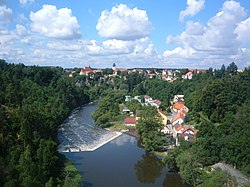 The Lužnice near Bechyně | |
  The Lužnice and its watershed until it enters the Vltava (magenta) | |
| Location | |
| Countries | |
| Cities | |
| Physical characteristics | |
| Source | |
| • location | Gratzen Mountains, Austria |
| • coordinates | 48°35′50.6″N 14°43′54″E / 48.597389°N 14.73167°E |
| • elevation | 970 m (3,180 ft) |
| Mouth | Vltava |
• coordinates | 49°13′49.7″N 14°23′21″E / 49.230472°N 14.38917°ECoordinates: 49°13′49.7″N 14°23′21″E / 49.230472°N 14.38917°E |
| Length | 197.4 km (122.7 mi)[1] |
| Basin size | 4,226.2 km2 (1,631.7 sq mi) |
| Discharge | |
| • location | mouth |
| • average | 24.3 m3/s (860 cu ft/s) |
| Basin features | |
| Progression | Vltava→ Elbe→ North Sea |
| Tributaries | |
| • right | Nežárka |

The Lužnice (Czech pronunciation: [ˈluʒɲɪtsɛ] (![]() listen); German: Lainsitz) is a river in the Czech Republic (204 km) starting in Austria (4 km). It flows into the Vltava river in Týn nad Vltavou (approximately 50 km north of České Budějovice). The river drains 4,226 square kilometers.
listen); German: Lainsitz) is a river in the Czech Republic (204 km) starting in Austria (4 km). It flows into the Vltava river in Týn nad Vltavou (approximately 50 km north of České Budějovice). The river drains 4,226 square kilometers.
The river was first mentioned in sources in the year 1179. The name is derived from an old Czech for water flowing through the meads. Several places on the river are popular destinations for recreation and canoeing.
Towns and cities on the Lužnice river[]
- Weitra (Austria)
- Gmünd (Austria)
- České Velenice
- Suchdol nad Lužnicí
- Třeboň
- Lomnice nad Lužnicí
- Veselí nad Lužnicí
- Soběslav
- Planá nad Lužnicí
- Sezimovo Ústí
- Tábor
- Bechyně
- Týn nad Vltavou
References[]
- ^ Niederösterreich Atlas (Lower Austria)
External links[]
| Wikimedia Commons has media related to Lužnice. |
- Basic information (in English)
- Detailed information (in Czech)
| hide Authority control | |
|---|---|
| General |
|
| National libraries | |
This Lower Austria location article is a stub. You can help Wikipedia by . |
This South Bohemian Region location article is a stub. You can help Wikipedia by . |
Categories:
- Tributaries of the Vltava
- Rivers of the South Bohemian Region
- Rivers of Lower Austria
- International rivers of Europe
- Lužnice basin
- Rivers of Austria
- Lužnice (river)
- Lower Austria geography stubs
- Austria river stubs
- South Bohemian Region geography stubs
- Czech Republic river stubs