Lybidska (Kyiv Metro)
Lybidska | |||||||||||
|---|---|---|---|---|---|---|---|---|---|---|---|
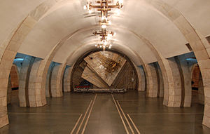 The Station Hall; Soviet decorative piece at the end of the hall will be removed to be displayed at a museum due to 2015 decommunization laws[1] | |||||||||||
| Location | Holosiivskyi District Kyiv Ukraine | ||||||||||
| Coordinates | 50°24′47″N 30°31′28″E / 50.41306°N 30.52444°ECoordinates: 50°24′47″N 30°31′28″E / 50.41306°N 30.52444°E | ||||||||||
| Line(s) | |||||||||||
| Construction | |||||||||||
| Structure type | Deep column station | ||||||||||
| Depth | 22.5 meters | ||||||||||
| Other information | |||||||||||
| Station code | 221 | ||||||||||
| History | |||||||||||
| Opened | 30 December 1984 | ||||||||||
| Previous names | Dzerzhynska | ||||||||||
| Passengers | |||||||||||
| 2011 | 28,500 (daily)[2] | ||||||||||
| Services | |||||||||||
| |||||||||||

Lybidska (Ukrainian: Либідська, (![]() listen)) is the 27th station of the Kyiv Metro system that serves the Ukrainian capital Kyiv. The station was opened as part of the Obolonsko–Teremkivska Line on 30 December 1984, located in between the Palats "Ukrayina" and Demiivska stations.
listen)) is the 27th station of the Kyiv Metro system that serves the Ukrainian capital Kyiv. The station was opened as part of the Obolonsko–Teremkivska Line on 30 December 1984, located in between the Palats "Ukrayina" and Demiivska stations.
The station provides passenger access to the Dzerzhynskoho Square, under which it is located. It served as the line's southern terminus for 26 years until 2010, when the line was extended to Vasylkivska. After the fall of Soviet Union in the beginning of the 1990s, the station was renamed "Lybidska" after the name of a nearby river—Lybid, on 2 February 1993.[3]
In 2011, the station has been listed as "newly discovered objects of cultural heritage," and monuments of architecture, town planning, and art.[4] In May 2016, it was decided that the Soviet decorative piece at the end of the central hall will be removed to be displayed at a museum due to 2015 decommunization laws.[1]
As of 2011, Lybidska has a daily ridership of 28,500,[2] and is operational every day from 05:48 to 00:00.[5]
Construction[]
Originally, a metro station was not planned to be built in the area, since there was no large residential neighborhoods or important transport junctions nearby.[6] During the planning process, the station carried the name of "Ploshcha Dzerzhynskoho" or "Zavod Imeni Dzerzhynskoho,"[6] although the name was simplified and settled upon Dzerzhynska (Ukrainian: Дзержинська), named after Felix Dzerzhynsky, communist politician of the Soviet Union.
However, the station was built as a temporary terminus, owing to the complexity of the hydro-geological situation in the area that would become the Holosiivska extension of the Obolonsko–Teremkivska Line. The line's extension southwards stretched on for more than 15 years, which became a major issue for commuters during rush hours. The station was one of the busiest terminus stations since many bus and marshrutka routes were routed through its vicinity, connecting commuters with areas on the outskirts of Kyiv which were lacking metro access. When the Holosiivska extension was inaugurated on 15 December 2010, the station was no longer a terminus.
Design[]
Lybidska was designed by a team of architects including Valentyn Ezhov, Anatoliy Krushynskyi, Tamara Tselikovska, Oleksiy Panchenko, in addition to artists Ernest Kotkov, Nikolai Bartossik. Prior to its renaming, the station featured a large bas-relief by M. Vronsky depicting Dzerzhinsky himself,[6] although it was removed shortly after the station was renamed.
Located at a depth of 25 metres (82 ft) underground,[6] Lybidska was designed as a deep column station that features a three separate halls—a central hall, and two platform halls—which are separated from each other by a row of columns. The row of columns in the station is unique in that it was designed as a double row, leaving an empty space in between each of the two rows.[6] The station doesn't have an above-ground vestibule on the Lybidska Square and only has one exit, which is connected to the station's central hall by an escalator tunnel.
Gallery[]

Station entrance
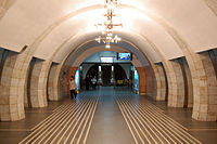
View from the central hall towards the station's escalator tunnel.

The three station halls are separated by a double row of columns, featuring a walkway in between the two rows.
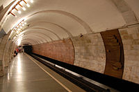
The station platform, with decorative piece seen on the far right.
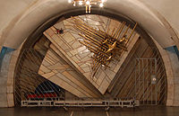
Decorative piece at the end of the central hall; due to be removed due to 2015 decommunization laws.[1]


References[]
- ^ Jump up to: a b c (in Ukrainian) From the dismantled in the Kiev subway communist symbols will be created a museum, Zerkalo Nedeli (8 May 2016)
- ^ Jump up to: a b "Passenger traffic". Kiev Meto forum - Unofficial website (in Russian). Archived from the original on 19 October 2013. Retrieved 31 March 2014.
- ^ Kyiv City Council and State Administration decree No. 16/116 "On the returning of historical names to streets, renaming parks of culture and leisure, metro stations." Passed on February 2, 1993. (in Ukrainian)
- ^ "Objects of Cultural heritage of the Pechersk Raion in Kyiv". Order of the Department of Cultural Heritage of the Kyiv City State Administration (in Ukrainian). Archived from the original (Microsoft Word .doc) on 3 November 2014. Retrieved 1 April 2014.
- ^ "Station "Zolotye Vorota"". Kiev Metro - Unofficial website (in Russian). Retrieved 31 March 2014.
- ^ Jump up to: a b c d e Totskiy, Oleg. ""Dvorets Ukraina" and "Lybedskaya"". Metro, which no longer exists (in Russian). LiveJournal. Retrieved 1 April 2014.
External links[]
 Media related to Lybidska at Wikimedia Commons
- Wiki-contributors. "Zoloti Vorota (metro station)". WWW Encyclopedia Kyiv (in Ukrainian). Retrieved 1 April 2014.

- Kyiv Metro stations
- Railway stations opened in 1984
- 1984 establishments in Ukraine