Slavutych (Kyiv Metro)
Slavutych | |||||||||||
|---|---|---|---|---|---|---|---|---|---|---|---|
 | |||||||||||
| Location | Darnytskyi District Kyiv Ukraine | ||||||||||
| Coordinates | 50°23′39″N 30°36′15″E / 50.39417°N 30.60417°ECoordinates: 50°23′39″N 30°36′15″E / 50.39417°N 30.60417°E | ||||||||||
| Owned by | Kyiv Metro | ||||||||||
| Line(s) | |||||||||||
| Platforms | 1 | ||||||||||
| Tracks | 2 | ||||||||||
| Construction | |||||||||||
| Structure type | underground | ||||||||||
| Platform levels | 1 | ||||||||||
| Other information | |||||||||||
| Station code | 321 | ||||||||||
| History | |||||||||||
| Opened | 30 December 1992 | ||||||||||
| Electrified | Yes | ||||||||||
| Services | |||||||||||
| |||||||||||

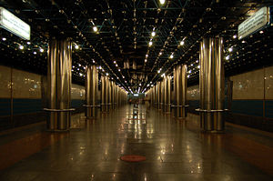
Slavutych (Ukrainian: Славутич, (![]() listen)) is a station on Kyiv Metro's Syretsko-Pecherska Line. It is situated between Vydubychi and Osokorky stations and was opened on 30 December 1992.
listen)) is a station on Kyiv Metro's Syretsko-Pecherska Line. It is situated between Vydubychi and Osokorky stations and was opened on 30 December 1992.
The station was designed by architect Alyoshkin. Slavutych station has 2 entrances. This station is situated on Mykoly Bazhana Avenue near the Southern Metro Bridge. This station is situated near the Dnieper river, Slavutych being an old name of the river.
Slavutych station is served by trains from 05:43hrs to 00:12hrs.
References[]
| Wikimedia Commons has media related to Slavutych Metro Station. |

This Kyiv Metro article is a stub. You can help Wikipedia by . |
This article about a Ukrainian railway station is a stub. You can help Wikipedia by . |
Categories:
- Kyiv Metro stations
- Railway stations opened in 1992
- 1992 establishments in Ukraine
- Ukrainian rapid transit stubs
- Ukrainian railway station stubs