Lyndon Township, Michigan
Lyndon Township, Michigan | |
|---|---|
 Lyndon Township Hall and Fire Department | |
 Location within Washtenaw County | |
 Lyndon Township Location within the state of Michigan | |
| Coordinates: 42°23′14″N 84°04′11″W / 42.38722°N 84.06972°WCoordinates: 42°23′14″N 84°04′11″W / 42.38722°N 84.06972°W | |
| Country | United States |
| State | Michigan |
| County | Washtenaw |
| Established | 1836 |
| Government | |
| • Supervisor | Pam Byrnes |
| • Clerk | Linda Reilly |
| Area | |
| • Total | 35.10 sq mi (90.9 km2) |
| • Land | 32.02 sq mi (82.9 km2) |
| • Water | 3.08 sq mi (8.0 km2) |
| Elevation | 1,014 ft (309 m) |
| Population (2010) | |
| • Total | 2,720 |
| • Density | 84.9/sq mi (32.8/km2) |
| Time zone | UTC-5 (Eastern (EST)) |
| • Summer (DST) | UTC-4 (EDT) |
| ZIP code(s) | |
| Area code(s) | 734 |
| FIPS code | 26-49780[1] |
| GNIS feature ID | 1626648[2] |
| Website | Official website |


Lyndon Township is a civil township of Washtenaw County in the U.S. state of Michigan. The population was 2,720 at the 2010 census.[3]
Communities[]
- Collins Plains was an unincorporated community founded in 1833.[4]
Geography[]
The township is located in the northwest corner of Washtenaw County. According to the United States Census Bureau, the township has a total area of 35.10 square miles (90.91 km2), of which 32.08 square miles (83.09 km2) is land and 3.02 square miles (7.82 km2) (8.60%) is water.[3]
The township contains numerous lakes and is also the westernmost boundary of the Waterloo State Recreation Area. M-52 runs diagonally south–north through the center of the township.
Demographics[]
This section needs to be updated. (February 2015) |
At the 2000 census,[1] there were 2,728 people, 877 households and 697 families residing in the township. The population density was 85.1 per square mile (32.8/km2). There were 1,055 housing units at an average density of 32.9 per square mile (12.7/km2). The racial makeup of the township was 89.85% White, 6.12% African American, 1.17% Native American, 0.33% Asian, 1.28% from other races, and 1.25% from two or more races. Hispanic or Latino of any race were 2.49% of the population.
There were 877 households, of which 35.8% had children under the age of 18 living with them, 70.4% were married couples living together, 5.7% had a female householder with no husband present, and 20.5% were non-families. 17.8% of all households were made up of individuals, and 4.2% had someone living alone who was 65 years of age or older. The average household size was 2.72 and the average family size was 3.07.
23.6% of the population were under the age of 18, 14.2% from 18 to 24, 29.0% from 25 to 44, 26.2% from 45 to 64, and 7.0% who were 65 years of age or older. The median age was 36 years. For every 100 females, there were 131.4 males. For every 100 females age 18 and over, there were 141.6 males.
The median household income was $71,595 and the median family income was $77,326. Males had a median income of $48,372 and females $30,054. The per capita income was $26,297. About 0.6% of families and 1.8% of the population were below the poverty line, including 1.3% of those under age 18 and none of those age 65 or over.
Gallery[]

Farmland on N. Territorial Rd.
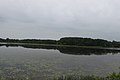
Green Lake, from M-52


References[]
- ^ a b "U.S. Census website". United States Census Bureau. Retrieved 2008-01-31.
- ^ U.S. Geological Survey Geographic Names Information System: Lyndon Township, Michigan
- ^ a b "Michigan: 2010 Population and Housing Unit Counts 2010 Census of Population and Housing" (PDF). 2010 United States Census. United States Census Bureau. September 2012. p. 44 Michigan. Retrieved August 4, 2021.
- ^ Romig, Walter (October 1, 1986) [1973]. Michigan Place Names: The History of the Founding and the Naming of More Than Five Thousand Past and Present Michigan Communities. Great Lakes Books Series (Paperback). Detroit, Michigan: Wayne State University Press. p. 126. ISBN 978-0-8143-1838-6.
External links[]
Municipalities and communities of Washtenaw County, Michigan, United States | ||
|---|---|---|
| Cities |  | |
| Villages | ||
| Charter townships | ||
| Civil townships | ||
| CDPs | ||
| Other unincorporated communities |
| |
| Defunct | ||
| Ghost towns |
| |
| Footnotes | ‡This populated place also has portions in an adjacent county or counties | |
| ||
- Townships in Washtenaw County, Michigan
- Townships in Michigan
- 1836 establishments in Michigan Territory
- Populated places established in 1836