Målselva
| Målselva | |
|---|---|
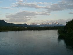 View of the Målselva river | |
 Location of the river | |
| Location | |
| Country | Norway |
| County | Troms og Finnmark |
| Municipalities | Målselv Municipality |
| Physical characteristics | |
| Source | Lille Rostavatn |
| • location | Rostadnes, Målselv, Troms og Finnmark |
| • coordinates | 69°01′18″N 19°30′53″E / 69.0218°N 19.5148°E |
| • elevation | 102 metres (335 ft) |
| Mouth | Malangen fjord |
• location | Målsnes, Målselv, Troms og Finnmark |
• coordinates | 69°18′23″N 18°31′29″E / 69.3065°N 18.5248°ECoordinates: 69°18′23″N 18°31′29″E / 69.3065°N 18.5248°E |
• elevation | 0 metres (0 ft) |
| Length | 140 km (87 mi) |
| Basin size | 6,144 km2 (2,372 sq mi) |
| Basin features | |
| River system | Målselvvassdraget |
| Tributaries | |
| • left | Barduelva |


The Målselva is a river in Målselv Municipality in Troms og Finnmark county, Norway. The 140-kilometre (87 mi) long river flows through the Målselvdalen valley and then empties into the , an arm of the Malangen fjord. The municipality and the valley through which the river runs are both named after the river.
The smaller rivers , , and converge near the Lille Rostavatn lake to form the Målselva river. Later, the river Barduelva joins it near Fossmoen and Bardufoss. The river drains a watershed of 6,144 square kilometres (2,372 sq mi).[1] The Målselva river passes by the main villages of Bardufoss, Andselv, and Skjold.
References[]
- ^ Store norske leksikon. "Målselva" (in Norwegian). Retrieved 2010-04-09.
External links[]
 Media related to Målselva at Wikimedia Commons
This article about a location in Troms og Finnmark is a stub. You can help Wikipedia by . |
Categories:
- Målselv
- Rivers of Troms og Finnmark
- Rivers of Norway
- Troms og Finnmark geography stubs
- Norway river stubs