Mönkebude
Mönkebude | |
|---|---|
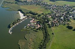 Aerial voew of Mönkebude | |
 Flag  Coat of arms | |
show Location of Mönkebude within Vorpommern-Greifswald district | |
 Mönkebude | |
| Coordinates: 53°46′N 13°58′E / 53.767°N 13.967°ECoordinates: 53°46′N 13°58′E / 53.767°N 13.967°E | |
| Country | Germany |
| State | Mecklenburg-Vorpommern |
| District | Vorpommern-Greifswald |
| Municipal assoc. | Am Stettiner Haff |
| Government | |
| • Mayor | Andreas Schubert |
| Area | |
| • Total | 34.23 km2 (13.22 sq mi) |
| Elevation | 3 m (10 ft) |
| Population (2020-12-31)[1] | |
| • Total | 773 |
| • Density | 23/km2 (58/sq mi) |
| Time zone | UTC+01:00 (CET) |
| • Summer (DST) | UTC+02:00 (CEST) |
| Postal codes | 17375 |
| Dialling codes | 039774 |
| Vehicle registration | VG |
| Website | www.amt-am-stettiner-haff.de |


Mönkebude is a municipality in the Vorpommern-Greifswald district, in Mecklenburg-Vorpommern, Germany.
References[]
- ^ "Statistisches Amt M-V – Bevölkerungsstand der Kreise, Ämter und Gemeinden 2020". Statistisches Amt Mecklenburg-Vorpommern (in German). July 2021.
| show Towns and municipalities in Vorpommern-Greifswald |
|---|
| Authority control |
|---|
This Vorpommern-Greifswald location article is a stub. You can help Wikipedia by . |
Categories:
- Municipalities in Mecklenburg-Vorpommern
- Vorpommern-Greifswald
- Bezirk Neubrandenburg
- Vorpommern-Greifswald geography stubs