Mārahau
Mārahau | |
|---|---|
 | |
 Flag | |
 | |
| Coordinates: 41°0′28″S 173°00′32″E / 41.00778°S 173.00889°ECoordinates: 41°0′28″S 173°00′32″E / 41.00778°S 173.00889°E | |
| Country | New Zealand |
| Territorial authority | Tasman |
| Ward | Motueka Ward |
| Area | |
| • Total | 6.14 km2 (2.37 sq mi) |
| Population (2018)[2] | |
| • Total | 231 |
| • Density | 38/km2 (97/sq mi) |
| Time zone | UTC+12 (NZST) |
| • Summer (DST) | UTC+13 (NZDT) |
| Area code | 03 |

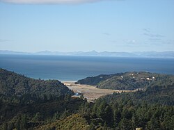
Mārahau is a very small town in the Tasman Region of the South Island of New Zealand, approximately 19 kilometres (12 mi) north of Motueka. Its location on Tasman Bay / Te Tai-o-Aorere and at the southern entrance of Abel Tasman National Park makes it a popular holiday destination for those keen on outdoor activities. People access the Abel Tasman from Mārahau by tramping, kayaking and water taxi.[3] In Mārahau itself, the beach offers sheltered and safe swimming, and horse trekking is popular throughout the busy summer season.[4]
Demographics[]
| Year | Pop. | ±% p.a. |
|---|---|---|
| 2006 | 186 | — |
| 2013 | 198 | +0.90% |
| 2018 | 231 | +3.13% |
| Source: [2] | ||
The SA1 statistical area of 7022558, which corresponds to Mārahau, covers 6.14 km2 (2.37 sq mi).[1] It had a population of 231 at the 2018 New Zealand census, an increase of 33 people (16.7%) since the 2013 census, and an increase of 45 people (24.2%) since the 2006 census. There were 78 households. There were 120 males and 111 females, giving a sex ratio of 1.08 males per female. The median age was 50.3 years (compared with 37.4 years nationally), with 27 people (11.7%) aged under 15 years, 30 (13.0%) aged 15 to 29, 129 (55.8%) aged 30 to 64, and 45 (19.5%) aged 65 or older.
Ethnicities were 97.4% European/Pākehā, 5.2% Māori, 1.3% Pacific peoples, 1.3% Asian, and 1.3% other ethnicities (totals add to more than 100% since people could identify with multiple ethnicities).
Although some people objected to giving their religion, 66.2% had no religion, 22.1% were Christian, 1.3% were Buddhist and 3.9% had other religions.
Of those at least 15 years old, 54 (26.5%) people had a bachelor or higher degree, and 27 (13.2%) people had no formal qualifications. The median income was $28,100, compared with $31,800 nationally. The employment status of those at least 15 was that 90 (44.1%) people were employed full-time, 57 (27.9%) were part-time, and 6 (2.9%) were unemployed.[2]
Mārahau is part of the Kaiteriteri-Riwaka SA2 statistical area.[5]
References[]
- ^ a b "ArcGIS Web Application". statsnz.maps.arcgis.com. Retrieved 23 July 2021.
- ^ a b c "Statistical area 1 dataset for 2018 Census". Statistics New Zealand. March 2020. 7022558.
- ^ "Marahau Travel Guide". Jasons Travel Media. Archived from the original on 23 March 2012. Retrieved 23 August 2011.
- ^ "Marahau travel". Lonely Planet. Retrieved 5 December 2020.
- ^ 2018 Census place summary: Kaiteriteri-Riwaka
External links[]
- Populated places in the Tasman District
- Populated places around Tasman Bay / Te Tai-o-Aorere