M501 railway (Croatia)
| Čakovec-Kotoriba railway | ||||||||||||||||||||||||||||||||||||||||||||||||||||||||||||||||||||||||||||||||||||||||||||||||||||||||||||||||||||||||||||||||||||||||||
|---|---|---|---|---|---|---|---|---|---|---|---|---|---|---|---|---|---|---|---|---|---|---|---|---|---|---|---|---|---|---|---|---|---|---|---|---|---|---|---|---|---|---|---|---|---|---|---|---|---|---|---|---|---|---|---|---|---|---|---|---|---|---|---|---|---|---|---|---|---|---|---|---|---|---|---|---|---|---|---|---|---|---|---|---|---|---|---|---|---|---|---|---|---|---|---|---|---|---|---|---|---|---|---|---|---|---|---|---|---|---|---|---|---|---|---|---|---|---|---|---|---|---|---|---|---|---|---|---|---|---|---|---|---|---|---|---|---|---|
 Between Čakovec and Čakovec-Buzovec M501 railway (left) runs parallel to L101 railway (right), both are single tracked. | ||||||||||||||||||||||||||||||||||||||||||||||||||||||||||||||||||||||||||||||||||||||||||||||||||||||||||||||||||||||||||||||||||||||||||
| Overview | ||||||||||||||||||||||||||||||||||||||||||||||||||||||||||||||||||||||||||||||||||||||||||||||||||||||||||||||||||||||||||||||||||||||||||
| Line number | M501 (HŽ) | |||||||||||||||||||||||||||||||||||||||||||||||||||||||||||||||||||||||||||||||||||||||||||||||||||||||||||||||||||||||||||||||||||||||||
| Technical | ||||||||||||||||||||||||||||||||||||||||||||||||||||||||||||||||||||||||||||||||||||||||||||||||||||||||||||||||||||||||||||||||||||||||||
| Line length | 42.4 km (26.3 mi) | |||||||||||||||||||||||||||||||||||||||||||||||||||||||||||||||||||||||||||||||||||||||||||||||||||||||||||||||||||||||||||||||||||||||||
| Track gauge | 1435 mm | |||||||||||||||||||||||||||||||||||||||||||||||||||||||||||||||||||||||||||||||||||||||||||||||||||||||||||||||||||||||||||||||||||||||||
| Operating speed | 60 to 80 km/h (37 to 50 mph) max. | |||||||||||||||||||||||||||||||||||||||||||||||||||||||||||||||||||||||||||||||||||||||||||||||||||||||||||||||||||||||||||||||||||||||||
| ||||||||||||||||||||||||||||||||||||||||||||||||||||||||||||||||||||||||||||||||||||||||||||||||||||||||||||||||||||||||||||||||||||||||||
The state border–Čakovec–Kotoriba–state border railway (Croatian: Pruga državna granica–Čakovec–Kotoriba–državna granica), officially designated as the M501 railway, is a 42.4-kilometre (26.3 mi) railway line in Croatia that connects the towns of Čakovec and Kotoriba to Slovene railway network via Pragersko and the Hungarian capital city Budapest via Murakeresztúr.[1][maps 1] The line is single-tracked and non-electrified.[2][3] The maximum permitted speed along the Slovene border–Čakovec section is 60 kilometres per hour (37 miles per hour), while the maximum speed along the rest of the line is 80 kilometres per hour (50 miles per hour).[4]
The M501 railway connects to the rest of the Croatian railway network in Čakovec, where the R201 line extending south to Varaždin forms a junction with the M501. The M501 also connects to the L101 in Čakovec. The L101 serves Mursko Središće to the north of the M501 and also the town of Lendava in Slovenia.[5]
History[]
The Čakovec–Kotoriba railway was opened in 1860 as part of a railway line from Nagykanizsa to Pragersko, the purpose was to connect Budapest to the existing Vienna–Trieste railway at the Pragersko. This was the first railroad built in present-day Croatia.[6] The route had three railway stations in Kotoriba, Donji Kraljevec, and Čakovec.[6]
In 1863 were built new railway stations in Mala Subotica and Donji Mihaljevec, in 1920 was opened railway stop Čakovec-Buzovec, and in 1940s were opened railway stops in , Macinec, and .[6]
During the World War II in 1941 the bridge over river Mura was blown up, but the second one was already built before end of the war.[6]
Gallery[]
Čakovec main railway station

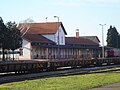
Buzovec, suburban railway station in Čakovec


See also[]
- List of railways in Croatia
Maps[]
- ^ Overview map of the state border–Čakovec–Kotoriba–state border railway (Map). OpenStreetMap. Retrieved December 11, 2013.
References[]
- ^ "Odluka o razvrstavanju željezničkih pruga" [Decision on Classification of Railways]. Narodne novine (in Croatian). Government of Croatia. 2006.
- ^ "Annex 3.3. Types of Lines". Network Statement 2014. HŽ Infrastruktura. p. 1. Archived from the original (PDF) on 2013-10-04.
- ^ "Annex 3.6. Electrification System". Network Statement 2014. HŽ Infrastruktura. p. 1. Archived from the original (PDF) on 2013-10-04.
- ^ "Annex 3.14. Distance Between Establishments and Maximum Permitted Line Speed". Network Statement 2014. HŽ Infrastruktura. pp. 17–18. Archived from the original (PDF) on 2013-10-04.
- ^ "Karta pruga" [Railway map] (in Croatian). Croatian Railways. Archived from the original on 2013-10-17.
- ^ a b c d Dragutin Matotek (2010). "Proslava 150 godina željeznice u Hrvatskoj" (PDF). Građevinar (in Croatian). Zagreb, Croatia: Croatian Association of Civil Engineers. 62 (5). Retrieved 2014-05-13.
External links[]
![]() Media related to M501 railway (Croatia) at Wikimedia Commons
Media related to M501 railway (Croatia) at Wikimedia Commons
- Railway lines in Croatia
- Buildings and structures in Čakovec
- Establishments in the Kingdom of Croatia (Habsburg)