Ma'ale HaShalom

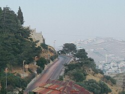
Ma'ale ha-Shalom (Hebrew: מעלה השלום, translates to Ascent of Peace), also known as the Pope's Road (Hebrew: כביש האַפִּיפְיוֹר, Kevish ha-Apifior), is a street in East Jerusalem.
Ma'ale HaShalom connects Route 60 to where it becomes Derech ha-Ofel. It goes along the southern border of the Old City, and has the Dung Gate where the entrance to the Jewish Quarter is found. It also goes alongside the Protestant Mount Zion Cemetery and Catholic cemeteries. It runs parallel to the Noble Sanctuary.[map 1] Though outside the walls of today's old city, the road is considered to be inside of historic sanctified Jerusalem.
Before 1964, the way to Mount Zion was a narrow dirt track. That year, Pope Paul VI planned to visit Jerusalem and in his honour, the Jordanians allowed for the widening and laying of a proper road to enable the Pope to be driven to the Coenaculum.[1][2][3][4]
Prior to the Six-Day War, this street was known as Ain el-loza.[5][unreliable source?]
References[]
- ^ Uzi Narkiss (1983). The liberation of Jerusalem: the battle of 1967. Vallentine, Mitchell. p. 34. ISBN 978-0-85303-209-0. Retrieved 23 June 2011.
The way to Mount Zion was a narrow dirt-track. While preparations were under way for the visit of Pope Paul VI to Jerusalem in January 1964, therefore, it was decided to widen the path and lay a proper road. The Pope had expressed a wish to pray at the Coenaculum; an improved road would make his journey more comfortable. The Jordanians did not object and the road was laid to within about 60 meters of the Coenaculum.
- ^ John M. Oesterreicher; Anne Sinai (1974). Jerusalem. John Day. p. 27. ISBN 978-0-381-98266-9. Retrieved 23 June 2011.
He ascended Mt. Zion to the Coenaculum, the hall in which the Last Supper had taken place, on a new road which had been constructed in his honor.
- ^ Aviva Bar-Am; Gershon Rechtman (1 December 1999). Jerusalem easywalks. Ingeborg Rennet Center for Jerusalem Studies. p. 13. ISBN 978-965-90048-6-7. Retrieved 23 June 2011.
In 1964 Pope Paul VI visited Mount Zion. The road that winds around the right side of the mountain was built especially for the car that drove him to Dormition Abbey and to the Cenacle — site of the Last Supper.
- ^ Nagel Publishers (1969). Israel. Nagel. p. 216. Retrieved 23 June 2011.
It can be reached by car on the "Pope's Road", built in 1964 on the occasion of his visit.
- ^ Israel falsely rewrites the Hostoric Identity of the Occupied Palestinian Territory Archived 2012-06-14 at the Wayback Machine, Applied Research Institute–Jerusalem
Further reading[]
- Rosenblum Irit (5 August 1998). "Night Vision (Article number - 824580)". Haaretz Archive.
...on foot from Absalom's Monument to Ma'ale Hashalom, which is lit as far as the Western Wall.
- Ronald L. Eisenberg (October 2006). The streets of Jerusalem: who, what, why. Devora Publishing. p. 240. ISBN 978-1-932687-54-5. Retrieved 2011-06-25.
Ma'aleh Hashalom (peace), symbolic name for the Dung Gate, with the hope that it should change from being a place to hurl refuse to a gate of peace.
Aerial photos and maps[]
- ^ Google (2011-06-28). "Ma'ale Ha-Shalom, Jerusalem" (Map). Google Maps. Google. Retrieved 2011-06-28.
Coordinates: 31°46′17.35″N 35°13′49.93″E / 31.7714861°N 35.2305361°E
- Streets in Jerusalem
- Mount Zion
- Jordanian construction in eastern Jerusalem
- 1960s in Jerusalem
