Ma Shi Chau
This article needs additional citations for verification. (December 2009) |
Coordinates: 22°27′13.94″N 114°13′45.33″E / 22.4538722°N 114.2292583°E


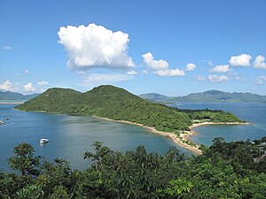
Ma Shi Chau (Chinese: 馬屎洲; Sidney Lau: Ma5Si2Jau1, literally "Horse Dung Island") is an island of Hong Kong, under the administration of Tai Po District. It is located in Tolo Harbour in the northeast New Territories (near Sam Mun Tsai). It is connected with another island, Yim Tin Tsai, by a tombolo traversable at low tide.
Geography[]
Ma Shi Chau has an area of 0.61 km2.[1] It is part of the Ma Shi Chau Special Area, as it exhibits tombolo and tide features rarely seen in Hong Kong. It is the largest island of the four in the Special Area, the others being Yeung Chau, Centre Island and an unnamed island near Yim Tin Tsai.[2][3]
It has sedimentary rock dating back to the Permian period that is protected by its Special Area status.
See also[]
References[]
External links[]
| Wikimedia Commons has media related to Ma Shi Chau. |
This Hong Kong location article is a stub. You can help Wikipedia by . |
- Uninhabited islands of Hong Kong
- Tai Po District
- Tidal islands
- Hong Kong UNESCO Global Geopark
- Tombolos
- Hong Kong geography stubs