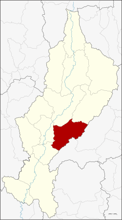
Mae Tha District, Lampang
Mae Tha
แม่ทะ | |
|---|---|
 District location in Lampang Province | |
| Coordinates: 18°8′6″N 99°30′48″E / 18.13500°N 99.51333°ECoordinates: 18°8′6″N 99°30′48″E / 18.13500°N 99.51333°E | |
| Country | Thailand |
| Province | Lampang |
| Tambon | 10 |
| Muban | 95 |
| Area | |
| • Total | 810.543 km2 (312.952 sq mi) |
| Population (2015) | |
| • Total | 59,357 |
| • Density | 77.8/km2 (202/sq mi) |
| Time zone | UTC+7 (ICT) |
| Postal code | 52150 |
| Geocode | 5210 |
Mae Tha (Thai: แม่ทะ, pronounced [mɛ̂ː tʰáʔ]) is a district (amphoe) of Lampang Province, northern Thailand.
Geography[]
Neighboring districts are (from the south clockwise): Sop Prap, Ko Kha, Mueang Lampang, Mae Mo of Lampang Province, Long and Wang Chin of Phrae Province.
The Phi Pan Nam Mountains dominate the landscape of the district.
Administration[]
Central administration[]
Mae Tha is subdivided into 10 sub-districts (tambons), which are further subdivided into 95 administrative villages (mubans).
| No. | Name | Thai | Villages | Pop.[1] |
|---|---|---|---|---|
| 1. | Mae Tha | แม่ทะ | 10 | 6,863 |
| 2. | Na Khrua | นาครัว | 12 | 10,099 |
| 3. | Pa Tan | ป่าตัน | 9 | 6,171 |
| 4. | Ban Kio | บ้านกิ่ว | 10 | 4,430 |
| 5. | Ban Bom | บ้านบอม | 6 | 2,693 |
| 6. | Nam Cho | น้ำโจ้ | 10 | 9,967 |
| 7. | Don Fai | ดอนไฟ | 8 | 4,284 |
| 8. | Hua Suea | หัวเสือ | 12 | 6,442 |
| 10. | Wang Ngoen | วังเงิน | 9 | 3,668 |
| 11. | San Don Kaeo | สันดอนแก้ว | 9 | 4,740 |
The missing number 9 belongs to tambon Sop Pat, which is now part of the District Mae Mo.
Local administration[]
There are five sub-district municipalities (thesaban tambons) in the district:
- Pa Tan Na Khrua (Thai: เทศบาลตำบลป่าตันนาครัว) consisting of sub-district Pa Tan and parts of sub-district Na Khrua.
- Siri Rat (Thai: เทศบาลตำบลสิริราช) consisting of sub-district San Don Kaeo.
- Mae Tha (Thai: เทศบาลตำบลแม่ทะ) consisting of sub-district Mae Tha.
- Nam Cho (Thai: เทศบาลตำบลน้ำโจ้) consisting of sub-district Nam Cho.
- Na Khrua (Thai: เทศบาลตำบลนาครัว) consisting of parts of sub-district Na Khrua.
There are five sub-district administrative organizations (SAO) in the district:
- Ban Kio (Thai: องค์การบริหารส่วนตำบลบ้านกิ่ว) consisting of sub-district Ban Kio.
- Ban Bom (Thai: องค์การบริหารส่วนตำบลบ้านบอม) consisting of sub-district Ban Bom.
- Don Fai (Thai: องค์การบริหารส่วนตำบลดอนไฟ) consisting of sub-district Don Fai.
- Hua Suea (Thai: องค์การบริหารส่วนตำบลหัวเสือ) consisting of sub-district Hua Suea.
- Wang Ngoen (Thai: องค์การบริหารส่วนตำบลวังเงิน) consisting of sub-district Wang Ngoen.
References[]
- ^ "Population statistics 2015" (in Thai). Department of Provincial Administration. Retrieved 2016-05-12.
External links[]
- amphoe.com (Thai)
Categories:
- Amphoe of Lampang Province
- Lampang province geography stubs

