Phrae Province
hideThis article has multiple issues. Please help or discuss these issues on the talk page. (Learn how and when to remove these template messages)
|
Phrae
แพร่ | |
|---|---|
 Phae Mueang Phi (Ghost Canyon) - Thailand's "Grand Canyon" near Phrae | |
 Flag  Seal | |
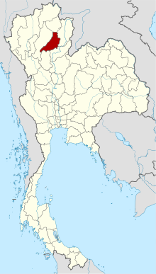 Map of Thailand highlighting Phrae Province | |
| Country | Thailand |
| Capital | Phrae |
| Government | |
| • Governor | Mr. Somwang Phuangbangpho (since October 2020)[1] |
| Area | |
| • Total | 6,483 km2 (2,503 sq mi) |
| Area rank | Ranked 32nd |
| Population (2019)[3] | |
| • Total | 441,726 |
| • Rank | Ranked 61st |
| • Density | 68/km2 (180/sq mi) |
| • Density rank | Ranked 67th |
| Human Achievement Index | |
| • HAI (2017) | 0.62525 "high" Ranked 14th |
| Time zone | UTC+7 (ICT) |
| Postal code | 54xxx |
| Calling code | 054 |
| ISO 3166 code | TH-54 |
| Website | www |
Phrae (Thai: แพร่; pronounced [pʰrɛ̂ː]; Northern Thai: ![]() ) is one of Thailand's seventy-six provinces (changwat) lies in upper northern Thailand. Neighboring provinces are (from north clockwise) Phayao, Nan, Uttaradit, Sukhothai, and Lampang.
) is one of Thailand's seventy-six provinces (changwat) lies in upper northern Thailand. Neighboring provinces are (from north clockwise) Phayao, Nan, Uttaradit, Sukhothai, and Lampang.
Geography[]
Phrae is in the valley of the Yom River. The Phi Pan Nam Range runs across the province from north to south in the west. The Phlueng Range is in the east. The total forest area is 4,204 km2 (1,623 sq mi) or 64.8 percent of provincial area.[2]
History[]
The history of Phrae dates back to the Haripunchai kingdom of the Mon. It became part of the Lan Na in 1443, when King Tilokaraj was on an expedition to capture Nan.
Symbols[]
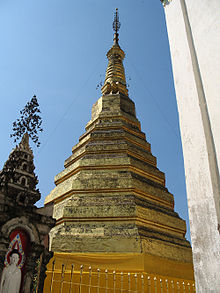
Provincial seal: According to legend the two cities of Phrae and Nan were once ruled by brothers. When they met to divide the land between them the one from Phrae rode on a horse, the one from Nan on a buffalo to the meeting point on top of a mountain. Hence Phrae uses a horse in their seal, while Nan uses a buffalo. When the provincial government proposed the seal in 1940, the Fine Arts Department suggested adding a historic building to the seal in addition to the horse, thus it now has the stupa of Phra Tat Cho Hae on the back of the horse. This temple is about nine kilometers southeast of the city of Phrae.[5] The provincial flower and tree is the Burmese Almondwood (Chukrasia tabularis). The provincial fish is black sharkminnow (Labeo chrysophekadion).
Human achievement index 2017[]
Since 2003, United Nations Development Programme (UNDP) in Thailand has tracked progress on human development at sub-national level using the (HAI), a composite index covering all the eight key areas of human development. National Economic and Social Development Board (NESDB) has taken over this task since 2017.[4]
| Health | Education | Employment | Income |
| 72 | 8 | 54 | 50 |
| Housing | Family | Transport | Participation |

|
 |

|
|
| 11 | 19 | 44 | 6 |
| Province Phrae, with an HAI 2017 value of 0.6252 is "high", occupies place 14 in the ranking. | |||
| showMap with provinces and HAI 2017 rankings |

Administrative divisions[]

Provincial government[]
The province is divided into eight districts (amphoes). These are further divided into 78 subdistricts (tambons) and 645 villages (mubans).
Local government[]
As of 26 November 2019 there are:[6] one Phrae Provincial Administration Organisation (ongkan borihan suan changwat) and 26 municipal (thesaban) areas in the province. Phrae has town (thesaban mueang) status. Further 25 subdistrict municipalities (thesaban tambon). The non-municipal areas are administered by 57 Subdistrict Administrative Organisations - SAO (ongkan borihan suan tambon).[3]
Transportation[]
The main road through Phrae is Route 101, which begins in Nan to the north, passes through Phrae, and leads to Sawankhalok, Sukhothai, and finally Kamphaeng Phet.
Phrae Airport is a small airport in Mueang Mo, on the east side of town. It handles only domestic flights from Don Mueang (DMK).[7]
The provincial railway station is Den Chai in Den Chai District, 24 km (14.9 mi) from Phrae town, since the town of Phrae does not have a rail to reach.[8]
Tourism[]
Wiang Kosai National Park (อุทยานแห่งชาติเวียงโกศัย) contains two waterfalls, the Mae Koeng Luang (น้ำตกแม่เกิ๋งหลวง), and the Mae Koeng Noi (น้ำตกแม่เกิ๋งน้อย). Streams from the falls flow into the Yom River. [9] Cave (ถ้ำผานางคอย). At the end of the cave is a stalagmite shaped like a woman holding a small child. In front of the Nang Koi (waiting woman) stone is a heart-shaped stalactite. They are the source of the legend of the love of a woman who waited for her lover until she turned to stone.[10]
Mae Yom National Park[11] and well-known Phae Mueang Phi Forest Park.
In addition, Phrae is also a province full of historic buildings. These buildings, all over 100 years old, were built in the Rattanakosin period or being used in the wood trading business that was once prosperous in the past.[12]
References[]
- ^ "ประกาศสำนักนายกรัฐมนตรี เรื่อง แต่งตั้งข้าราชการพลเรือนสามัญ" [Announcement of the Prime Minister's Office regarding the appointment of civil servants] (PDF). Royal Thai Government Gazette. 137 (Special 238 Ngor). 16. 9 October 2020. Retrieved 13 April 2021.
- ^ Jump up to: a b "ตารางที่ 2 พี้นที่ป่าไม้ แยกรายจังหวัด พ.ศ.2562" [Table 2 Forest area Separate province year 2019]. Royal Forest Department (in Thai). 2019. Retrieved 6 April 2021, information, Forest statistics Year 2019, Thailand boundary from Department of Provincial Administration in 2013CS1 maint: postscript (link)
- ^ Jump up to: a b รายงานสถิติจำนวนประชากรและบ้านประจำปี พ.ส.2562 [Statistics, population and house statistics for the year 2019]. Registration Office Department of the Interior, Ministry of the Interior. stat.bora.dopa.go.th (in Thai). 31 December 2019. Retrieved 26 February 2020.
- ^ Jump up to: a b Human achievement index 2017 by National Economic and Social Development Board (NESDB), pages 1-40, maps 1-9, retrieved 14 September 2019, ISBN 978-974-9769-33-1
- ^ "General Information". Phrae Province. Archived from the original on 18 June 2013. Retrieved 18 May 2015.
- ^ "Number of local government organizations by province". dla.go.th. Department of Local Administration (DLA). 26 November 2019. Retrieved 10 December 2019.
39 Phrae: 1 PAO, 1 Town mun., 25 Subdistrict mun., 57 SAO.
- ^ "(PRH) Phrae Airport Overview". Flightstats. Retrieved 13 May 2015.
- ^ "Getting to Phrae Province". Sawadee.com (in Thai).
- ^ "About Phrae". Tourism Authority of Thailand (TAT). Archived from the original on 2019-01-31. Retrieved 2019-01-31.
- ^ Tham Pha Nang Khoi Archived January 15, 2011, at the Wayback Machine[dead link]
- ^ "Mae Yom National Park". Department of National Parks (DNP) Thailand. Archived from the original on 21 January 2015. Retrieved 18 May 2015.
- ^ Prachachuen, Na Chart (2020-06-22). "ตึกเก่าเมืองแพร่ : รู้ไปโม้ด" [Old buildings of Phare : Know it all]. Khaosod (in Thai). Retrieved 2021-04-26.
External links[]
 Phrae travel guide from Wikivoyage
| Wikimedia Commons has media related to Phrae Province. |
- Phrae Province website
- Phrae provincial map, coat of arms and postal stamp Archived October 6, 2010, at the Wayback Machine[dead link]
- Knowledge of Encyclopediathai Travel & Country Guides Welcome to Phrae Province
| show Places adjacent to Phrae Province |
|---|
| show Authority control |
|---|
Coordinates: 18°8′42″N 100°8′26″E / 18.14500°N 100.14056°E

- Phrae Province
- Provinces of Thailand