Chonburi Province
Chonburi
ชลบุรี | |
|---|---|
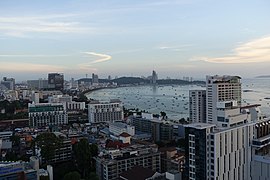 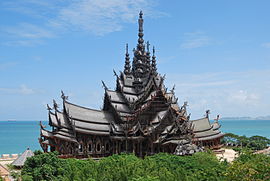  (From top to bottom) View of Pattaya skyline, Sanctuary of Truth, Phra Chuthathut Palace of Koh Si Chang | |
 Flag  Seal | |
| Motto(s): "ทะเลงาม ข้าวหลามอร่อย อ้อยหวาน จักสานดี ประเพณีวิ่งควาย" ("Beautiful sea, Khao Lam delicious, Sweet cane, Fine weaving and Buffalo running tradition") | |
 Location within Thailand | |
| Coordinates: 13°13′N 101°11′E / 13.217°N 101.183°ECoordinates: 13°13′N 101°11′E / 13.217°N 101.183°E | |
| Country | Thailand |
| Region | Eastern Thailand |
| Provincial Capital | Chonburi |
| Largest City | Pattaya |
| Settled | c. 7th century, as Phrarot city |
| Founded as city | 1897–1932 |
| Founded as province | 1933 |
| Governing body | Chonburi Provincial Office |
| Government | |
| • Type | Province |
| • Governor | Phakkhrathon Thianchai (since October 2016) |
| Area | |
| • Province | 4,363 km2 (1,685 sq mi) |
| Area rank | 50th |
| Elevation | 50 m (160 ft) |
| Population (2018)[2] | |
| • Province | 1,535,445 |
| • Rank | 9th |
| • Density | 351.9/km2 (911/sq mi) |
| • Density rank | 10th |
| Human Achievement Index | |
| • HAI (2017) | 0.6613 "high" Ranked 6th |
| Time zone | UTC+07:00 (ICT) |
| Postal code | 20xxx |
| Calling code | 038 |
| ISO 3166 code | TH-20 |

Chonburi (Thai: ชลบุรี, RTGS: Chon Buri, [tɕ͡ʰōn bū.rīː] (![]() listen)) is a province of Thailand (changwat) located in eastern Thailand.[4] Its capital is also named Chonburi. Neighbouring provinces are (clockwise from north) Chachoengsao, Chanthaburi, and Rayong, while the Gulf of Thailand is to the west. Pattaya, a major tourism destination in Thailand, is located in Chonburi, along with Laem Chabang, the country's primary seaport. The population of the province has grown rapidly and now totals 1.7 million residents, although a large portion of the population is floating or unregistered.[5] The registered population as of 31 December 2018 was 1.535 million.[2]
listen)) is a province of Thailand (changwat) located in eastern Thailand.[4] Its capital is also named Chonburi. Neighbouring provinces are (clockwise from north) Chachoengsao, Chanthaburi, and Rayong, while the Gulf of Thailand is to the west. Pattaya, a major tourism destination in Thailand, is located in Chonburi, along with Laem Chabang, the country's primary seaport. The population of the province has grown rapidly and now totals 1.7 million residents, although a large portion of the population is floating or unregistered.[5] The registered population as of 31 December 2018 was 1.535 million.[2]
Toponymy[]
The word chon originates from the Sanskrit word जल; jala meaning 'water', and the word buri from Sanskrit पुरि; puri meaning 'town' or 'city', hence the name of the province means 'city of water'.
History[]
Chonburi has been recognized since the Dvaravati Period and during the reigns of the Khmer Empire and the Sukhothai Kingdom. Chonburi was initially only a small agricultural town and fishing community, but during the Ayutthaya Kingdom (1350-1767), Chonburi was classified as a commodore class city. On the Triphum map, it appeared along with more major towns such as Bangsai (บางทราย; now a sub-district of Chonburi), Bangplasoi (บางปลาสร้อย; now a downtown area in Chonburi), Bangphrarua (บางพระเรือ; now a sub-district of Si Racha), and Banglamung (บางละมุง; now a district of Chonburi). Although it was a small town, it enriched the natural resources both on land and at sea. Moreover, those in Chonburi contacted the Chinese sailors, who came to trade with Siam.
Prehistoric[]
Chonburi Province used to be an ancient community that used to be inhabited by Neolithic humans since prehistoric times. Because there had been archaeological excavations and found traces of the ancient prehistoric community in the Phan Thong River, which is in the area of Wat Khok Phanom Dee, Tha Kham Subdistrict, Phanat Nikhom District. It can be assumed that in the past, the area of Chonburi Province used to be home to three prosperous ancient cities: Phrarot, Si Phalo and Phaya Rae. By the territory of these 3 cities together as Chonburi Province at present.
Which archaeological sites discovered in that time found valuable archaeological objects such as axes, polished stone, jewelry such as bracelets, beads, pottery using a string. And found the remains of seafood as well. It was made known that this area was much closer to the coast than today. All of the above mentioned archaeological sites are part of the evidence that shows the long history of Chonburi Province.
Historic[]
Ayutthaya Period[]
In the Ayutthaya period, Chonburi city appears as evidence in the feudal palace in 1376 as a provincial town. Until Ayutthaya was defeated by Burma in 1767, King Taksin passed through the area of Chonburi province today, before hitting Chanthaburi and successfully returned the army to recover Ayutthaya.
Rattanakosin Period[]
Later in the early Rattanakosin period, Chonburi has not been officially established. Chonburi consists of 3 major cities, namely Bang Pla Soi, Phanat Nikhom City and Banglamung.
Later in Siamese revolution of 1932, there has been a big change in the form of government. Causing the county administrative system to be abolished by the Administrative Regulations of the Kingdom of Siam Act 1933 and has canceled the "city" administrative area throughout the kingdom, then set up a "province" instead of making the city of Bang Pla Soi, Phanat Nikhom City and Banglamung and Chonburi became "Chonburi Province" until now.
Symbols[]
The provincial seal shows the hill Khao Sam Muk, on which there is a sala with a statue of the goddess Chao Mae Sahm Muk, who, it is believed, protects seafarers and the local population.[6]
The provincial tree and flower is the New Guinea rosewood (Pterocarpus indicus, called Mai Pradu in Thai).[citation needed]
The provincial motto is "Beautiful beaches, delicious khao lam, sweet sugar cane, delicate basketry products, and buffalo racing."[7]
Geography[]
The province is on the Bay of Bangkok, the northern end of the Gulf of Thailand. The Khao Khiao mountain range stretches from the northwest to the southeast of the province. The plains of the north were long used for farming. Laem Chabang, between Chonburi and Pattaya, is one of the few deep-water harbours of Thailand. The total forest area is 551 km2 (213 sq mi) or 12.2 percent of provincial area.[8]
The provincial permanent legal population rose at nearly four per cent annually, from 1,040,865 in 2000 to 1,554,365 in 2010.[5] There is a large floating population of long-term non-Thai residents without permanent status, on a perpetual tourist visa and/or migrant workers (legal or not), as well as heavy, short-term tourist influxes.
Demographics[]
This section is empty. You can help by . (August 2019) |
Religion[]
Religion in Chonburi (census 2015)[9]
According to a 2015 survey,[9] around 97.87% of the population of Chonburi practices Buddhism, followed by Islam with 1.56% and Christianity with 0.60%.
| Religion | Census 2015[9] | % |
|---|---|---|
| Buddhism | 1,256,081 | 97.87% |
| Islam | 20,000 | 1.56% |
| Christianity | 7,707 | 0.60% |
| Other religions | 800 | 0.06% |


Administrative divisions[]
Provincial government[]
Chonburi Province consists of 11 districts (amphoe). These are further subdivided into 92 subdistricts (tambon) and 710 villages (muban).
| Map | # | Name | Thai | Population (2018) | Subdivisions |
|---|---|---|---|---|---|

| |||||
| — Districts — | |||||
| 1 | Mueang Chonburi | เมืองชลบุรี | 335,063 | 18 tambon — 107 muban | |
| 2 | Ban Bueng | บ้านบึง | 103,377 | 8 tambon — 52 muban | |
| 3 | Nong Yai | หนองใหญ่ | 23,625 | 5 tambon — 24 muban | |
| 4 | Bang Lamung | บางละมุง | 315,437 | 8 tambon — 72 muban | |
| 5 | Phan Thong | พานทอง | 69,429 | 11 tambon — 76 muban | |
| 6 | Phanat Nikhom | พนัสนิคม | 124,637 | 20 tambon — 185 muban | |
| 7 | Si Racha | ศรีราชา | 301,799 | 8 tambon — 73 muban | |
| 8 | Ko Sichang | เกาะสีชัง | 4,560 | 1 tambon — 7 muban | |
| 9 | Sattahip | สัตหีบ | 165,492 | 5 tambon — 40 muban | |
| 10 | Bo Thong | บ่อทอง | 50,318 | 6 tambon — 47 muban | |
| 11 | Ko Chan | เกาะจันทร์ | 37,670 | 2 tambon — 27 muban | |
Local government[]
The local governments are overseen by the Pattaya City Special Local Government in Pattaya and the Chonburi Provincial Administrative Organisation (CPOA, ongkan borihan suan changwat chonburi) throughout Chonburi. The 47 municipalities are split up into two city municipalities (thesaban nakhon), 10 town municipalities (thesaban mueang),[10] and 35 subdistrict municipalities (thesaban tambon). Local communities are also overseen by 50 subdistrict administrative organisations (SAO, ongkan borihan suan tambon).[11]
Transport[]
Road[]
The Bangkok-Chonburi-Pattaya Motorway (Hwy 7) is linked with Bangkok's Outer Ring Road (Hwy 9) with another intersection at Si Nakharin and Rama IX Junction.
The Bang Na-Trat Highway (Hwy 34) from Bang Na travels through Bang Phli and crosses the Bang Pakong River into Chonburi. There is a Chonburi bypass that meets Sukhumvit Road (Hwy 3), passing Bang Saen Beach, Bang Phra, Pattaya and Sattahip.
Airports[]
Chonburi is about 120 kilometres (75 mi) by road from Suvarnabhumi Airport (BKK), the country's largest international airport. By road, it is accessed from Sukhumvit Road and Motorway 7 from Bangkok. Chonburi is also served by scheduled flights via U-Tapao International Airport (UTP), which is a 45-minute drive south of the city.
Highways[]
The main road through Chonburi is Thailand Route 3, also known as Sukhumvit Road. To the northeast, it connects to Bangkok, and to the south, it connects to Rayong Province, Chanthaburi Province and Trat Province. Route 344 leads east to Klaeng (which is also on Route 3). Route 7 runs parallel to Route 3 but bypasses the densely populated coastal area, connecting to the beach resort city of Pattaya.
Rail[]
The State Railway of Thailand, the national passenger rail system, provides service in the province, with the main station being Chon Buri Railway Station.
Health[]
Many hospitals exist in Chonburi, both public and private. Chonburi has one university hospital, Burapha University Hospital. Its main hospital operated by the Ministry of Public Health is Chonburi Hospital. Hospitals operated by other organisations, such as the Thai Red Cross Society's Queen Savang Vadhana Memorial Hospital and the Queen Sirikit Naval Hospital run by the Royal Thai Navy, are also found in the province.
Educational facilities[]
Universities[]
- Burapha University (BUU)
- Kasetsart University Si Racha Campus (KU SRC)
- Rajamangala University of Technology Tawan-ok (RMUTTO)
- Sripatum University Chonburi Campus (SPU)
- Thailand National Sports University (TNSU)
- Thammasat University Pattaya Campus (TU)
Colleges[]
- Graduate School of Public Administration, National Institute of Development Administration (GSPA NIDA)
- Interior College (IC)
- Panyapiwat Institute of Management (PIM)
Human Achievement Index 2017[]
| Health | Education | Employment | Income |
| 34 | 2 | 2 | 7 |
| Housing | Family | Transport | Participation |

|
 |

|
|
| 74 | 18 | 5 | 72 |
| Province Chonburi, with an HAI 2017 value of 0.6613 is "high", occupies place 6 in the ranking. | |||
Since 2003, the United Nations Development Programme (UNDP) in Thailand has tracked progress on human development at a sub-national level using the (HAI), a composite index covering all eight key areas of human development. The National Economic and Social Development Board (NESDB) has taken over this task since 2017.[3]
| Rank | Classification |
| 1 - 15 | "high" |
| 16 - 30 | "somewhat high" |
| 31 - 45 | "average" |
| 45 - 60 | "somewhat low" |
| 61 - 77 | "low" |
| showMap with provinces and HAI 2017 rankings |

Tourism[]
Some nine million visitors to the province were recorded in 2012, of which 6.1 million were from abroad, 2.2 million of these being Russian.[12]
One major tourist attraction is the Chonburi Buffalo Race (งานประเพณีวิ่งควาย), which takes place in the districts of Ban Bueng and Nong Yai. The animals are dressed outrageously or creatively by owners. Assembled in the courtyard in front of the town hall, the buffaloes partake in racing or physical fitness and fashion contests. The Chonburi Buffalo Race festival started over 100 years ago.[13] Usually, the races will be complemented with booths selling locally-made items, stage performances, games, and beauty contests.[14] The annual Buffalo Race is held around the 11th lunar month, normally in October. It takes seven days and takes place on the field in front of the city and provincial government offices. The highlight of the festival is the buffalo race, which takes place on the last two days. This race is 100 metres (110 yd) long. The prize for the first nose past the finish line is a trophy and some money.[15]
Songkran day in Bangsaen (Ko Phra Sai Wan Lai Bangsaen) is a tradition that has been held continuously for over ten years at Bang Saen Beach and Laem Thaen. The event takes place between April 16–17 of each year. The highlight of this event is a contest in which the contestants build a sand Buddha at Bangsaen Beach. In each Buddha sand arch is a decoration. The combination of the sea atmosphere and Thai decorations has helped this become one of the most popular Songkran festivals in Thailand. Other activities also take place, such as meriting alms to monks, bathing Buddha images, pouring water on the elders, traditional sporting events, sea boxing competitions, and oyster sheep competitions. Seafood and local food are often sold, along with other local products as part of One Tambon One Product (OTOP). Well-known artists have also given concerts at the event.
See also[]
- Chonburi F.C.
- Sriracha F.C.
- Pattaya United F.C.
- Supreme Chonburi VC
References[]
- ^ Advancing Human Development through the ASEAN Community, Thailand Human Development Report 2014, table 0:Basic Data (PDF) (Report). United Nations Development Programme (UNDP) Thailand. pp. 134–135. ISBN 978-974-680-368-7. Retrieved 17 January 2016, Data has been supplied by Land Development Department, Ministry of Agriculture and Cooperatives, at Wayback Machine.CS1 maint: postscript (link)[dead link]
- ^ Jump up to: a b "ร่ยงานสถิติจำนวนประชากรและบ้านประจำปี พ.ศ.2561" [Statistics, population and house statistics for the year 2018]. Registration Office Department of the Interior, Ministry of the Interior. stat.bora.dopa.go.th (in Thai). 31 December 2018. Archived from the original on 2 April 2019. Retrieved 20 June 2019.
- ^ Jump up to: a b Human achievement index 2017 by National Economic and Social Development Board (NESDB), pages 1-40, maps 1-9, retrieved 14 September 2019, ISBN 978-974-9769-33-1
- ^ "About Chon Buri". Tourism Authority of Thailand (TAT). Retrieved 31 May 2015.
- ^ Jump up to: a b http://www.citypopulation.de/php/thailand-admin.php
- ^ "Chonburi". THAILEX Travel Encyclopedia. Archived from the original on 2015-11-27. Retrieved 31 May 2015.
- ^ "History". สำนักงานการท่องเที่ยวและกีฬาจังหวัดชลบุรี. Retrieved 2019-05-23.
- ^ "ตารางที่ 2 พี้นที่ป่าไม้ แยกรายจังหวัด พ.ศ.2562" [Table 2 Forest area Separate province year 2019]. Royal Forest Department (in Thai). 2019. Retrieved 6 April 2021, information, Forest statistics Year 2019CS1 maint: postscript (link)
- ^ Jump up to: a b c http://cbi.onab.go.th/index.php?option=com_content&view=article&id=327&Itemid=206 Religion in Chonburi
- ^ "ข้อมูลพื้นฐานของอปท" [Basic information of local authorities] (in Thai). 2020. Retrieved 22 September 2020.
- ^ https://www.dla.go.th/work/abt/index.jsp Archived 2019-07-19 at the Wayback Machine Thesaban - 14 June 2562 (2019)
- ^ "Chon Buri sees 9mn visitors in 2012". The Nation. 8 April 2013. Retrieved 2 October 2018.
- ^ สำนักงานคณะกรรมการวัฒนธรรมแห่งชาติ, ประเพณีวิ่งควาย (1994). ชีวิตไทยชุดบรรพบุรุษของเรา.กรุงเทพฯ: คุรุสภาลาดพร้าว, 2013
- ^ "Chonburi buffalos race Oct. 14-20". Pattaya Mail. 2013-09-06. Archived from the original on 10 June 2015. Retrieved 31 May 2015.
- ^ "Chonburi Buffalo Racing". Tourism Authority of Thailand (TAT). Archived from the original on 19 April 2019. Retrieved 19 April 2019.
External links[]
| Wikimedia Commons has media related to Chonburi Province. |
 Chonburi travel guide from Wikivoyage
- Provincial administration (Thai)
| show Places adjacent to Chonburi Province |
|---|
| show Authority control |
|---|
- Chonburi Province
- Provinces of Thailand
- Gulf of Thailand
- Bay of Bangkok