Nakhon Pathom Province
Nakhon Pathom
จังหวัดนครปฐม | |
|---|---|
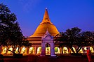   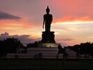   (Clockwise from top left) Phra Pathom Chedi, Sanam Chandra Palace, Phutthamonthon Buddhism Park, Don Wai floating market, Thai Human Imagery Museum, Prince Mahidol Hall of Mahidol University Salaya Campus | |
 Flag  Seal | |
| Nickname(s): City of Big Chedi | |
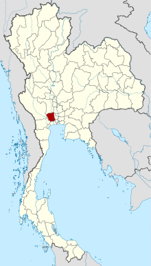 Map of Thailand highlighting Nakhon Pathom Province | |
| Country | Thailand |
| Capital | Mueang Nakhon Pathom |
| Government | |
| • Governor | Surasak Charoensirichot (since 2020) |
| Area | |
| • Total | 2,168 km2 (837 sq mi) |
| Area rank | Ranked 66th |
| Population (2019)[2] | |
| • Total | 920,030 |
| • Rank | Ranked 25th |
| • Density | 424/km2 (1,100/sq mi) |
| • Density rank | Ranked 8th |
| Human Achievement Index | |
| • HAI (2017) | 0.6354 "high" Ranked 12th |
| Time zone | UTC+7 (ICT) |
| Postal code | 73xxx |
| Calling code | 034 & 02 |
| ISO 3166 code | TH-73 |
| Website | www |
Nakhon Pathom (Thai: จังหวัดนครปฐม, pronounced [náʔkʰɔ̄ːn pā.tʰǒm], (Pronunciation)) is one of the central provinces (changwat) of Thailand. Neighbouring provinces are (from north clockwise) Suphan Buri, Ayutthaya, Nonthaburi, Bangkok, Samut Sakhon, Ratchaburi, and Kanchanaburi. The capital city of Nakhon Pathom Province is Nakhon Pathom.
Nakhon Pathom Province is home to the Phra Pathom Chedi, a chedi commissioned by King Mongkut (Rama IV) and completed by King Chulalongkorn (Rama V) in 1870. The chedi is a reminder of the long vanished Dvaravati civilization that once flourished here and by tradition Nakhon Pathom is where Buddhism first came to Thailand.[citation needed] The province itself is known for its many fruit orchards.[4]
Geography[]
Nakhon Pathom is a small province 56 km from Bangkok. It is in the alluvial plain of central Thailand and is drained by the Tha Chin River (sometimes called the Nakhon Chai Si), a tributary of the Chao Phraya River. There are many canals that have been dug for agriculture. The total forest area is just 1.6 km2 (0.62 sq mi) or 0.8 per mille of provincial area.[5] The capital city of Bangkok has grown until it borders Nakhon Pathom.
Climate[]
Nakhon Pathom province has a tropical savanna climate (Köppen climate classification category Aw). Winters are dry and warm. Temperatures rise until May. Monsoon season runs from May through October, with heavy rain and somewhat cooler temperatures during the day, although nights remain warm. Climatological data for the years 2012–2013: Its maximum temperature is 40.1 °C (104.2 °F) in April 2013 and the lowest temperature is 12.0 °C (53.6 °F) in December 2013. The highest average temperature is 37.4 °C (99.3 °F) in April 2013 and the minimum average temperature is 16.5 °C (61.7 °F) in December 2013. The average relative humidity is 75% and the minimum relative humidity is 22%. Annual rainfall is 1,095 millimeters. The number of rainy days was 134 days for the year 2013.
Toponymy[]
The name derives from the Pali words Nagara Pathama, meaning 'first city', and Nakhon Pathom is often referred as Thailand's oldest city.[citation needed] Archaeological remains have been linked to the (pre-Thai) Dvaravati kingdom, dating to the 6th through 11th centuries.[4]
History[]
Prehistoric[]
Archaeological evidence that may have existed in prehistoric times has been found such as a polished stone ax, stone profit piece, remnants of bronze vessels that look like bowls and fragments of human bones at the archaeological site, Nai Jiw Boon Raksa at Ban Yang Subdistrict, Mueang Nakhon Pathom District.
Kasetsart University archaeological site number 1 found ancient human skulls, stone beads and a number of bronze gains. It shows that the site was the site of a prehistoric human burial ground at the end of the Iron Age, about 2,000 years ago.
Dvaravati period[]
The ancient city of Nakhon Pathom began to have a settlement for at least around the 8th to 11th century, with great prosperity during the 13th-14th century and deteriorated in the 17th century.
The location of the ancient city of Nakhon Pathom around 11-16th century is located on the coast. It is a town located in the west bank of the Chao Phraya River. From archaeological evidence, a large boat anchor was found at Dharamshala Temple. In addition, there are also names of villages in the city of Nakhon Pathom that represent areas that used to be on the sea, such as Laem Bua, Laem Krachao, Cape Mai, Laem Cha-ui, or Ban Ao. The important ancient city of Nakhon Pathom during the Dvaravati period was Nakhon Chaisi town or called Nakhon Chai Lin or the city of Phra Prathon. The city is located about 2 kilometers east of Phra Pathom Chedi and is centered on Phra Prathon Chedi. There is another ancient city, the city of Kamphaeng Saen. It is located 20 kilometers northwest of Nakhon Pathom, which has discovered ancient evidence from both cities.
Sukhothai period[]
In the Sukhothai period, the name of Nakhon Pathom is still unknown. The ancient city of Nakhon Pathom in the Sukhothai period was under the rule of Sukhothai. The ancient city of Nakhon Pathom was called “Nakhon Phra Krit”.
Ayutthaya period[]
During the reign of Maha Chakkraphat it was during the Burmese army to attack Ayutthaya several times. Maha Chakkraphat combine the 3 cities into a new city and named after the ancient city that “Nakhon Chaisri City”. It is a city set up to prepare to mobilize troops for battle and control the troops from fleeing. It is also a city with a commercial district and receiving products from outside to sell. The new Nakhon Chaisri is a small town about 10 kilometers east of the old Nakhon Chaisri town.
Rattanakosin period[]
During the reign of King Rama V, has changed the provincial government, by combining the districts into a group called "Monthon" depending on the Ministry of Interior. Monthon Nakhon Chaisri was established in 1895, consisting of the city of Nakhon Chaisi, Suphanburi and Samut Sakhon and began construction of the southern railway line through Nakhon Pathom, which at that time was still an overgrown forest.
During the reign of King Rama VI, has created Sanam Chandra Palace, By construct more roads, including building bridge across Khlong Chedi Bucha, and changed it name from the city "Nakhon Chaisi" to "Nakhon Pathom" in 1916.
Economy[]
In mid-2019, the Department of Airports (DOA) proposed the construction of a new airport in the province, to relieve pressure on Bangkok's two existing airports. The 20 billion baht airport would occupy 3,500 rai of land in Bang Len District and Nakhon Chai Si District. Its capacity would be 25 million passengers annually. If approved, construction would start in 2023 and the airport would be operational by 2025 or 2026.[6] When fully built-out, the airport will accommodate 80-100 seat aircraft flying between Bangkok and second-tier provinces to ease congestion at Suvarnabhumi and Don Mueang airports. The project site has low population density, only 200 households on 400 plots of land.[7]
Symbols[]
The provincial seal shows Phra Pathom Chedi, at 127 meters the tallest pagoda in the world.[citation needed] It is in the center of the city of Nakhon Pathom, and has been an important Buddhist center since the 6th century. The current building was created by King Mongkut in 1860. On the pagoda a royal crown is depicted, the symbol for King Mongkut's work on reconstructing the pagoda.
The provincial flag is blue with the yellow provincial seal in the middle of the flag.[8]
The provincial tree is Chan, scientific name Diospyros decandra. The provincial slogan is "sweet pomelos, delicious rice, beautiful young ladies".[4]
Administrative divisions[]
Provincial government[]
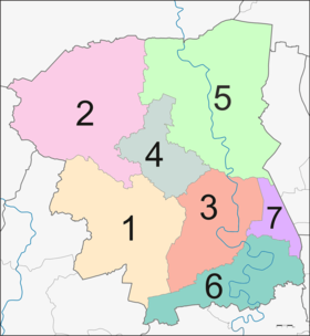

The province is divided into seven districts (amphoes). The districts are further subdivided into 106 subdistricts (tambons) and 904 villages (mubans).
Local government[]
As of 10 October 2020 there are: one Nakhon Pathom Provincial Administrative Organization - PAO (ongkan borihan suan changwat) and twenty-six municipal (thesaban) areas in the province. The capital Nakhon Pathom has city (thesaban nakhon) status. Further five have town (thesaban mueang) status and twenty subdistrict municipalities (thesaban tambon).[2]
| City municipality | people | ||
| 1 | Nakhon Pathom[9] | 74,446 |
| Town municipalities | people | 3 | Sam Phran[10] | 17,329 | |
| 1 | Rai Khing[11] | 32,819 | 4 | Nakhon Pathom[12] | 14,004 |
| 2 | Krathum Lom[13] | 27,587 | 5 | Sam Khwai Phueak[14] | 11,139 |
| Subdistrict mun. | people | ||||
| 1 | Om Yai[15] | 24,027 | 11 | Khun Kaeo[16] | 7,915 |
| 2 | Sam Ngam[17] | 13,956 | 12 | Sisa Thong[18] | 7,221 |
| 3 | Bang Kratheuk | 13,056 | 13 | Thammasala[17] | 7,086 |
| 4 | Sala Ya[19] | 11,180 | 14 | Kamphaeng Saen[17] | 7,009 |
| 5 | Phrong Maduea | 10,896 | 15 | Ta Kong | 6,785 |
| 6 | Khlong Yong | 10,526 | 16 | Don Yai Hom[20] | 6,519 |
| 7 | Bo Phlap[21] | 9,519 | 17 | Huai Phlu[17] | 2,217 |
| 8 | Map Khae | 8,630 | 18 | Bang Luang[17] | 2,163 |
| 9 | Bang Len[17] | 8,429 | 19 | Rang Krathum[17] | 2,162 |
| 10 | Nakhon Chai Si[17] | 8,226 | 20 | Lam Phaya[17] | 1,949 |
The non-municipal areas are administered by 91 Subdistrict Administrative
Organizations (SAO) (ongkan borihan suan tambon).[22]
| Municipalities | Communities | Groups | |
| Rai Khing[23] | 28 | 3 | |
| Krathum Lom[24] | 29 | - | |
| Om Yai[25] | 26 | - |
Human achievement index 2017[]
| Health | Education | Employment | Income |
| 40 | 5 | 22 | 8 |
| Housing | Family | Transport | Participation |

|
 |

|
|
| 56 | 57 | 25 | 62 |
| Province Nakhon Pathom, with an HAI 2017 value of 0.6354 is "high", occupies place 12 in the ranking. | |||
Since 2003, United Nations Development Programme (UNDP) in Thailand has tracked progress on human development at sub-national level using the (HAI), a composite index covering all the eight key areas of human development. National Economic and Social Development Board (NESDB) has taken over this task since 2017.[3]
| Rank | Classification |
| 1 - 15 | "high" |
| 16 - 30 | "somewhat high" |
| 31 - 45 | "average" |
| 45 - 60 | "somewhat low" |
| 61 - 77 | "low" |
| showMap with provinces and HAI 2017 rankings |

References[]
- ^ Advancing Human Development through the ASEAN Community, Thailand Human Development Report 2014, table 0:Basic Data (PDF) (Report). United Nations Development Programme (UNDP) Thailand. pp. 134–135. ISBN 978-974-680-368-7. Retrieved 17 January 2016, Data has been supplied by Land Development Department, Ministry of Agriculture and Cooperatives, at Wayback Machine.CS1 maint: postscript (link)[dead link]
- ^ Jump up to: a b "สถิติทางการทะเบียน" [Registration statistics]. bora.dopa.go.th. Department of Provincial Administration (DOPA). December 2019. Retrieved 10 October 2020.
Download จำนวนประชากร ปี พ.ศ.2562 - Download population year 2019
- ^ Jump up to: a b Human achievement index 2017 by National Economic and Social Development Board (NESDB), pages 1-40, maps 1-9, retrieved 14 September 2019, ISBN 978-974-9769-33-1
- ^ Jump up to: a b c "Official Infos about Nakhon Pathom" (PDF). Archived from the original (PDF) on 2012-05-09. Retrieved 2019-08-16.
- ^ "ตารางที่ 2 พี้นที่ป่าไม้ แยกรายจังหวัด พ.ศ.2562" [Table 2 Forest area Separate province year 2019]. Royal Forest Department (in Thai). 2019. Retrieved 6 April 2021, information, Forest statistics Year 2019CS1 maint: postscript (link)
- ^ Hongtong, Thodsapol (20 July 2019). "Third Bangkok airport proposed". Bangkok Post. Retrieved 25 July 2019.
- ^ Hongthong, Thodsapol (22 September 2019). "New airport under scrutiny". Bangkok Post. Retrieved 22 September 2019.
- ^ "Logo". Province Nakhon Pathom. nakhonpathom.go.th. 2019. Retrieved 20 November 2019.
- ^ "พระราชกฤษฎีกา จัดตั้งเทศบาลนครนครปฐม จังหวัดนครปฐม พ.ศ.๒๕๔๒" [Royal Decree Establish of Nakhon Nakhon Pathom city municipality, Nakhon Pathom province B.E.2542 (1999)] (PDF). Royal Thai Government Gazette. 116 (110 Kor): 6–9. 10 November 1999. Retrieved 14 December 2019.
- ^ "เทศบาลเมืองสามพราน" [Samphran Municipality]. samphrancity.go.th (in Thai). 2020. Retrieved 10 October 2020.
changed its status from Samphran subdistrict municipality to Samphran town municipality. Since 1 February 2008.
- ^ "ประวัติความเป็นมา" [History]. raikhing.go.th (in Thai). 2020. Retrieved 10 October 2020.
The first Subdistrict Administrative Organization (SAO) has raised its position as the Rai Khing town municipality on 30 May 2008.
- ^ "Number of local government organizations: Summary elevating local authorities". dla.go.th. Department of Local Administration (DLA). 1 February 2013. Retrieved 10 October 2020.
No.3.2 Established Nakhon Pathom Subdistrict Administrative Organization (SAO), Mueang district, Nakhon Pathom province is Nakhon Pathom town municipality, effectively 1 March 2013.
- ^ "ประวัติความเป็นมา" [History]. krathumlom.go.th (in Thai). 2020. Retrieved 10 October 2020.
It was later established as Krathum Lom town municipality on 2 June 2008.
- ^ "ประกาศกระทรวงมหาดไทย เรื่อง จัดตั้งองค์การบริหารส่วนตำบลสามควายเผือก อำเภอเมืองนครปฐม จังหวัดนครปฐม เป็นเทศบาลเมืองสามควายเผือก" [Notification of the Ministry of Interior Re: Establishment of Sam Kwai Phueak Subdistrict Administrative Organization, Mueang Nakhon Pathom district, Nakhon Pathom province Is Sam Kwai Phueak town municipality] (PDF). Royal Thai Government Gazette. 136 (Special 237 Ngor): 18. 23 September 2019. Retrieved 5 September 2020.
- ^ "ประวัติเทศบาล" [Municipal history]. omyai.go.th (in Thai). 2020. Retrieved 10 October 2020.
and was raised as a municipality by the Change Sanitation districts to Municipality Act, 24 February B.E.2542 effective on 25 May 1999.
- ^ "Number of local government organizations: Summary elevating local authorities". dla.go.th. Department of Local Administration (DLA). 11 December 2012. Retrieved 10 October 2020.
No.3.3 Established Khun Kaeo Subdistrict Administrative Organization (SAO), Nakhon Chai Si district, Nakhon Pathom province is Khun Kaeo subdistrict municipality, effectively 31 January 2013.
- ^ Jump up to: a b c d e f g h i "พระราชกฤษฎีกา เปลี่ยนแปลงฐานะของสุขาภิบาลเป็นเทศบาล พ.ศ.๒๕๔๒" [Royal Decree Change Sanitation districts to Municipality Act B.E.2542] (PDF). Royal Thai Government Gazette. 116 (9 Kor): 1–4. 24 February 1999. Retrieved 10 October 2020, effective 25 May 1999.CS1 maint: postscript (link)
- ^ "Number of local government organizations: Summary elevating local authorities". dla.go.th. Department of Local Administration (DLA). 11 February 2020. Retrieved 10 October 2020.
No.1.9 Established Sisa Thong Subdistrict Administrative Organization (SAO), Nakhon Chai Si district, Nakhon Pathom province is Sisa Thong subdistrict municipality, effectively 17 April 2020.
- ^ "ประวัติความป็นมา" [History]. salaya.go.th (in Thai). 2020. Retrieved 10 October 2020.
Change the status from Sanitation district to Sala Ya subdistrict municipality. According to the Change Sanitation districts to Municipality Act, 24 February B.E.2542 effective on 25 May 1999.
- ^ "ประวัติความป็นมา" [History]. donyaihom.go.th (in Thai). 2020. Retrieved 10 October 2020.
Don Yai Hom subdistrict municipality was elevated from Don Yai Hom sanitation district on 25 may 1999 to Don Yai Hom subdistrict municipality, located in Mueang district, Nakhon Pathom province.
- ^ "Number of local government organizations: Summary elevating local authorities". dla.go.th. Department of Local Administration (DLA). 27 February 2012. Retrieved 10 October 2020.
No.3.42 Established Bo Phlap Subdistrict Administrative Organization (SAO), Mueang district, Nakhon Pathom province is Bo Phlap subdistrict municipality, effectively 1 June 2012.
- ^ Department of Provincial Administration (DOPA), List of 5,324 SAO's information as of date 20 December 2019, 91 SAO's (no.1084-1175) were established in 1995 (16), in 1996 (58) and in 1997 (17).
- ^ "ข้อมูลชุมชน" [Community information]. raikhing.go.th (in Thai). 2020. Retrieved 30 October 2020.
28 communities in 3 groups.
- ^ "ผูันำชุมชน" [Community leaders]. krathumlom.go.th (in Thai). 2020. Retrieved 30 October 2020.
29 communities.
- ^ "ชุมชน" [Municipal community]. omyai.go.th (in Thai). 2020. Retrieved 30 October 2020.
26 communities.
External links[]
 Nakhon Pathom travel guide from Wikivoyage
- Province page from the Tourist Authority of Thailand
- Website of province (Thai only)
- Nakhon Pathom provincial map, coat of arms and postal stamp
- Jesada Technik Museum(Thai only)
| show Places adjacent to Nakhon Pathom Province |
|---|
Coordinates: 13°55′N 100°7′E / 13.917°N 100.117°E

| show Authority control |
|---|
- Nakhon Pathom Province
- Provinces of Thailand